74 F. high in the Twin Cities Monday.
78 F. average high for June 11.
69 F. high temperature on June 11, 2011 at KMSP.
37 mph: peak wind gust in the metro area yesterday.
13.6 mph: average wind speed yesterday.
52 mph wind gust Sunday evening at 8:55 pm as severe
storms moved through; 59 mph. gust at Olivia. The local NWS office has a
complete list of peak wind gusts
here.
.36" rain predicted for the Twin Cities by Friday morning at 7 am (00z NAM
model).
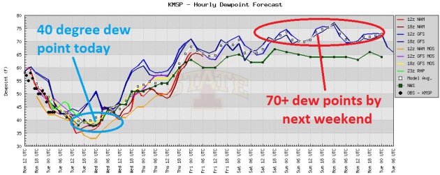
70+ dew points possible by next weekend.
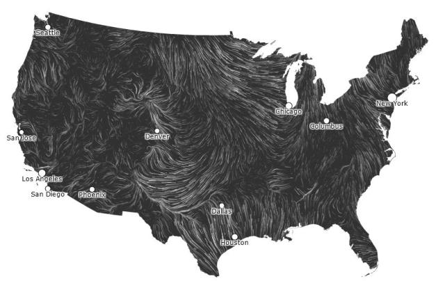
Fresh Air. For a high-resolution, short-term wind forecast for the USA
click here.
Enjoy the cool, comfortable breeze while you can - today easily the
most comfortable day in sight (through September?) A rerun of heat and
humidity is likely by Thursday.
Dew Point Prediction for MSP (00z NAM model output):
41 F. Today.
52 F. Wednesday.
65 F. Thursday.
Serious Case Of The Weekend Muggies? A few of the
models are showing 70+ dew points next weekend, roughly two and a half
times more water vapor floating overhead than today. Something to look
forward to.
"
A graduation ceremony is an event where the commencement speaker
tells thousands of students dressed in identical caps and gowns that
"individuality" is the key to success". - Robert Orben. Image above:
someecards.com.
"
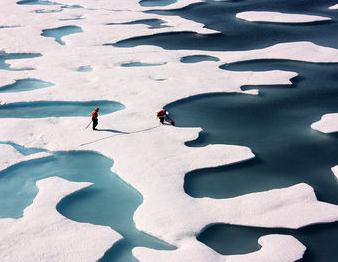
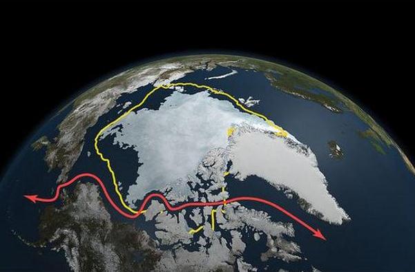
The Arctic is the first place where we're starting to see the
security impacts of climate change and the geopolitical tensions," said
Heather Exner-Pirot, a researcher with the U of S International Centre
for Northern Governance and Development." - from a story at Regina's Leader-Post; details below. Photo: Kathyrn Hansen, NASA.
2011: 35th year in a row in which global temperatures were above historical 20th century norms.
2010, 2005: virtual tie for warmest year on record, worldwide.
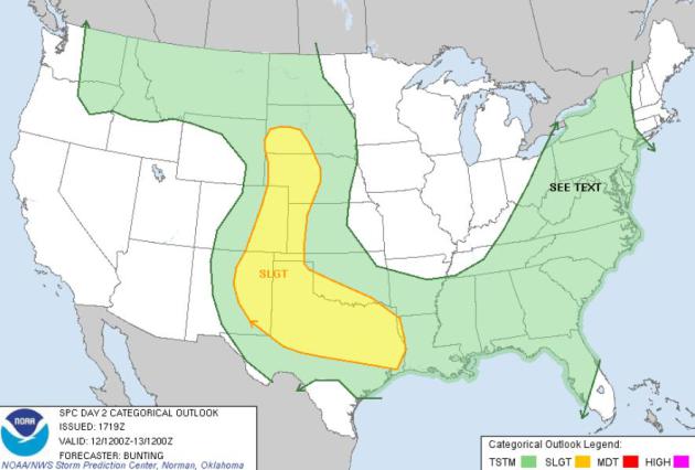
Tuesday Severe Risk. Storms from Cheyenne to Denver,
on south to Midland and Dallas may exceed severe limits again today; a
potential for damaging hail, even a few isolated tornadoes, according to
SPC.
Heat: America's Number One Killer. Hurricanes,
tornadoes and floods "make news" more than extreme heat, which usually
claims a smaller number of lives, often in combination with another
medical ailment, like heart or respiratory problems. Heat can be the
straw that breaks the proverbial camel's back, pushing many elderly
people into cardiac arrest. Here's a good summary of the risk posed by
heat from the Buffalo National Weather Service, via
Facebook: "
Did
you know that “HEAT” is the number one weather-related killer in the
United States, resulting in hundreds of fatalities each year. In fact,
on average, excessive heat claims more lives each year than floods,
lightning, tornadoes and hurricanes combined. In the disastrous heat
wave of 1980, more than 1,250 people died. In the heat wave of 1995 more
than 700 deaths in the Chicago area were attributed to heat. In August
2003, a record heat wave in Europe claimed an estimated 50,000 lives.
Although “close” to record high temperatures across many locations
today, you should still take precautions if you are going to be outside
in the “HEAT”.
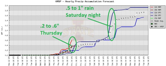
Not Quite As Hot. We may not hit 90 after all,
although I suspect we'll come close to 90 Thursday, again Friday. Right
now the wettest days (based on the ECMWF guidance above) appear to be
Thursday, Sunday (sorry Dad) and Monday, when another cool front may
spark the most widespread showers and T-storms. We are definitely in a
wet pattern overall.
Best Chance Of Tripping Over Puddles? The arrival of
warmer, stickier air sets off a few T-showers from Wednesday night into
Thursday, another sloppy bullseye Saturday night into a portion of
Sunday, based on the latest model ensemble.
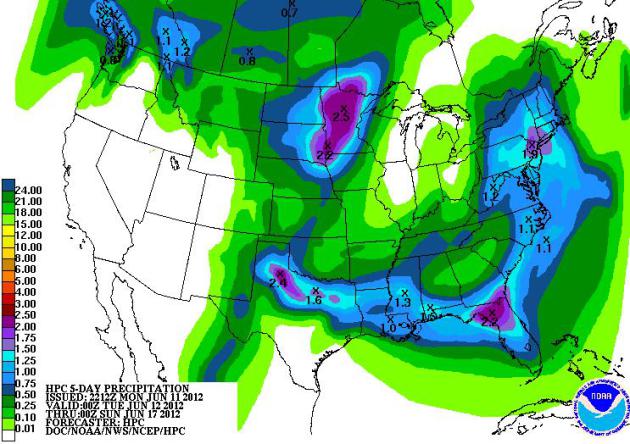
5-Day Rainfall Projections. NOAA HPC's QPF (enough
acronyms?) shows a 2-2.5" rainfall prediction over Minnesota and
northern Florida; dry weather lingering for much of the west, making a
bad fire scenario considerably worse.
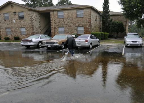
Severe Flooding In Escambia County, Florida Forces Evacuations In Florida's Panhandle. As much as 22" of rain has soaked the Pensacola area, prompting evacuations, washing out roads and bridges.
Huffington Post has more information: "
Floodwaters
from torrential rains damaged homes and closed roads throughout the
Florida Panhandle, cutting power to the county jail and sending
residents to emergency shelters as the area braced for additional rains
Sunday. A tornado connected with the storm system also uprooted trees
and destroyed chicken houses Sunday in southeastern Alabama, where an
emergency official said a few homes were damaged but no injuries were
reported. "I actually saw it myself coming out of our church door – my
first tornado I have ever witnessed," said Margaret Mixon, emergency
management director for rural Geneva County."
Photo credit above: "
Forest Creek apartment resident
Calvin Grace checks on the flooding conditions at his unit Sunday, June
10, 2012, after receiving nearly two feet of water on Saturday, in
Pensacola, Fla. Floodwaters from torrential rains damaged homes and
closed roads throughout the Florida Panhandle, cutting power to the
county jail and sending residents to emergency shelters as the area
braced for additional rains Sunday." (AP Photo/The Pensacola News Journal, Tony Giberson)
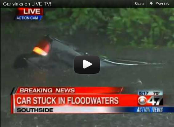
Car Sinks In Floodwaters During Live (Jacksonville) TV Segment. Here is more detail (and video) from
TVSpy.com: "
A car sank in a flooded creek behind WTEV-WAWS
during the stations’ severe weather coverage, making for a tense moment
of live TV (video above). It turned out that a teenager, along with a
friend, was driving the car and, confused by the rising waters, took a
wrong turn into a creek. Both young men escaped to safety, but the car
was ruined. Following the incident, the joint Jacksonville stations
orchestrated some more live TV drama when a local car dealership
surprised the kid with a new car. Video inside…"
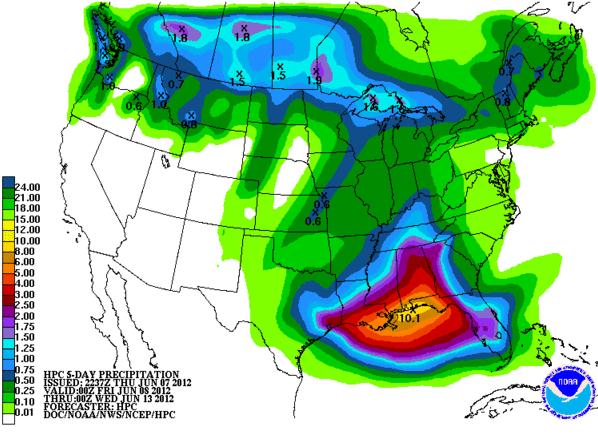
Giving Credit Where Credit Is Due. Here is NOAA
HPC's 5-Day Precipitation Outlook issued last Thursday. Notice the 10"
bullseye over the Florida Panhandle. Yes, that forecast verified alright
- as much as 22" of rain for portions of Escambia County, in the
Pensacola area, since last Friday.
That's 2 hurricane's worth of rain!
Fire Season 2012: "We're Just Getting Started".
AccuWeather meteorologist Ken Reeves has a good summary of the fire season, compared with last year, to date: "
Here are some statistics to show why I have said that this has been a rather slow start to the season.
So far in 2012, there has been 22,976 fires burning 838,853 acres.
In 2011 to date, there was 29,857 fires burning a much larger 3,450,882 acres.
The 10-year average to date is 32,576 fires burning 1,422,752 acres.
Therefore, 2012 has been well below the 10-year average for the
number of fires and acres burned and far below the number of acres
burned to date last year. Though interesting, we are in the infancy of
the meat of the fire season. A lot can change over the next several
month before the fire season peaks late summer and early fall."
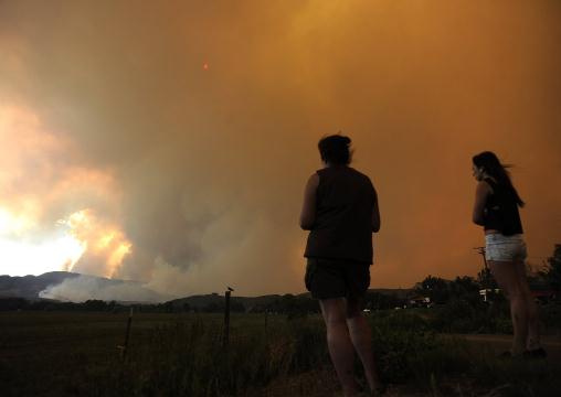
Photo credit above: "
Donna Dundon, left, and Arianna
Roupinian, of Fort Collins, Colo., watch a fire burning in a
mountainous area about 15 miles west of Fort Collins, on Sunday, June
10, 2012. Firefighters on Sunday were fighting wildfires that have
spread quickly in parched forests in Colorado and New Mexico, forcing
hundreds of people from their homes and the evacuation of wolves from a
sanctuary. The Colorado fire grew to 22 square miles within about a day
of being reported and has destroyed or damaged 18 structures." (AP Photo/The Denver Post, Helen H. Richardson)
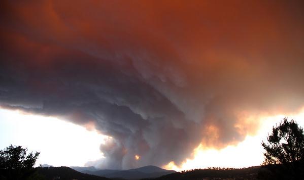
"Pyrocumulus". Here is an amazing example of
pyrocumulus, clouds formed by hot updrafts generated by the Little Bear
Fire in New Mexico. Details and more photos from
Expose-Sure 101 in Alto, New Mexico: "
As
of 6 a.m. this morning the Little Bear Fire is 26,000 acres, current
cost $1.2 million, zero percent contained. Transferred to Type 1
incident command this morning at the White Mountain Elementary School
Cmplex. No new evacuations. No evacuees will be allowed back to their
homes. Highway closures remain in effect. Two Heavy helicopter, 2
Blackhawk helicopters, 2 medium helicopters, two light helicopters, 3
large air tankers and two light tankers in addition to at least 300 more
firefighters The "heel of the fire line on ski run road is being held.
Neighborhoods at the intersections of HWY 48 and airport road and in
Sonterra have been "compromised". The Rio Bontio valley and Angus church
/lower copper canyon have also been "compromised". Several structures
are destroyed and hundreds remain threatened."
Floods And Misery In Southern England As A Month's Worth of Rain Falls In A Few Hours. Some amazing details from the U.K.
Independent: "
Forecasters
warned there was little prospect of summer as once again more than a
month’s worth of rain fell in just a few hours today bringing flooding
and misery to parts of southern England. Storm conditions are set to
return later in the week, the Met Office said, as homes were evacuated
along the south coast while a hospital in Worthing was forced to divert
emergency admissions after wards were inundated with water. The
Environment Agency issued more than 40 flood warnings and alerts on
rivers across Surrey, Sussex and Hampshire which were lashed with
torrential downpours. Worst affected were the rivers Mole and Barnham."
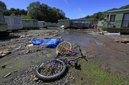
Photo credit above: "
The scene at Riverside Caravan Park
in Llandre, Wales after swollen waters breached the banks of the River
Lery and flooded the caravan park Saturday June 9, 2012. Around 150
people had to be rescued from homes and caravans after severe floods
hit west Wales. Holidaymakers and residents were helped to safety in a
large-scale rescue operation mounted by fire crews, coastguard
lifeboats and military helicopters when water swept through caravan
parks and villages near Aberystwyth in Wales." (AP Photo/PA Wire)
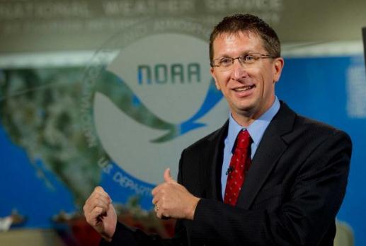
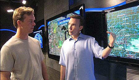
New Hurricane Center Head Turned Fear Into Career. AP and
Timesunion.com has the story; here's an excerpt: "
MIAMI (AP) — When the National Hurricane Center's new director was growing up on the Florida and Texas coasts, tropical storms frightened him. Decades later, Rick Knabb
understands storms better, but he still doesn't like them. "I'm still
very scared of hurricanes," says Knabb, who left The Weather Channel to
become chief of the U.S. government's hurricane forecasting hub in
Miami on June 1. "I have a very healthy respect for what they can do
and I try to channel that fear into preparedness and action." As
hurricane center director, Knabb will spend a lot of time urging
coastal residents to prepare for a major hurricane by securing their
homes. He will tell them to create evacuation plans and stock enough
supplies to last several days without power."
Photo credit above: "
In this June 5, 2012 photo, Rick
Knabb discusses his role as the new Director of the National Hurricane
Center in MIami. He might better understand the tropical storm systems
that frightened him as a child growing up on the hurricane-prone coasts
of Florida and Texas, but that doesn’t mean he’s learned to like their
howling winds. “I’m still very scared of hurricanes,” says Knabb, who
left The Weather Channel to become chief of the U.S. government’s
hurricane forecasting hub in Miami. “I have a very healthy respect for
what they can do and I try to channel that fear into preparedness and
action.” (AP)
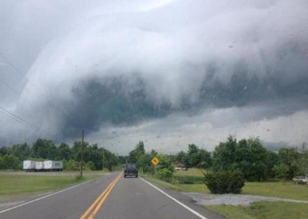
"Shelf Cloud." Thanks to StormchaseKY, who snapped this ominous pic in Muhlenberg County, Kentucky.
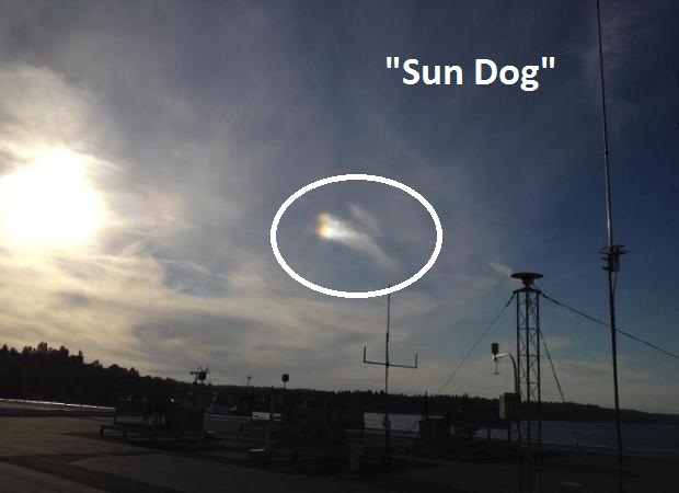
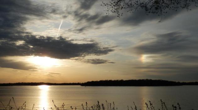
"Sun Dog". Here is an explanation of this optical illusion, courtesy of the Seattle office of The National Weather Service, via
Facebook: "
This
is an image of a mock sun or sundog captured this afternoon. The
scientific name for this phenomenon is ‘parhelion,’ which is Greek and
means, ‘besides the sun.’ It occurs when sunlight passes through ice
crystals, which refract or bend the light horizontally (acting as
prisms)."
"Ask Paul". Weather-related Q&A.
Paul,
"
Three weeks ago, on Saturday morning, our moving vehicle, at 50
mph, was struck by a bolt of lightning. What are the odds on that??"
Ed Bohl III
Managing Director, Schawk!
Ed - glad you're OK. A vehicle is a fairly safe place to ride out an
electrical storm. It is a crude (rolling) "Faraday Cage", which
Wikipedia explains: "
A Faraday cage's operation depends on the fact that an external static electrical field will cause the electric charges
within the cage's conducting material to redistribute themselves so as
to cancel the field's effects in the cage's interior. This phenomenon
is used, for example, to protect electronic equipment from lightning strikes and electrostatic discharges."
The
National Lightning Safety Institute has calculated the odds of any one person being struck by lightning in a given year:
USA population = 280,000,000
1000 lightning victims/year/average
Odds = 1 : 280,000 of being struck by lightning
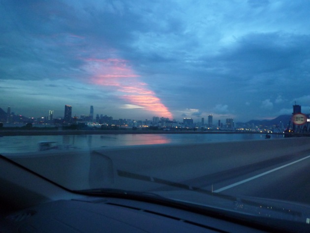
Hello again Paul -
"Hope you're well. Thought of
you when I saw this. Not a brilliant shot (because it was taken from our
moving car) but it was looking southwest over Hong Kong's old Kai Tak
airport site and the harbor - as this strange shaft of orange light
appeared in the clouds."
Joe Kainz
Thanks Joe - great pic. It may have been caused by a
narrow break in a line of showers and T-storms that allowed the setting
sun to shine on mid-level clouds over the harbor.
Best Not To Complain About The Rain. Why? Because it's been snowing over northern Manitoba. Eden Prairie consulting meteorologist Dean DeHarpporte writes:
"
Paul, maybe you have noticed but it has been snowing all morning
in Thompson, Manitoba, which is about 530 miles north of the US
border, and Gillam Manitoba, which is about 100 miles east northeast of
Thompson. Hudson Bay is 100-150 miles to the northeast of both
towns.Thompson, population 13,000, is a stop on the railway that goes up
from Winnipeg to Churchill where I once went (in January).
The precip was rain overnight but there has
apparently been enough upward motion in the cyclone over Hudson Bay to
cause enough cooling to make the change to snow, which has been
classified as heavy at times. I just noticed it on the surface map
reports so I dont know if there has been accumulation. My very
subjective impression is that heavy snow this late in the season is rare
that far south of Hudson Bay. Surprisingly (to me) Thompson is
classified as subarctic climate (Köppen Dfc), but now I see why."
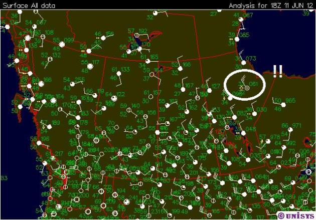
* map above courtesy of
Unisys.
.
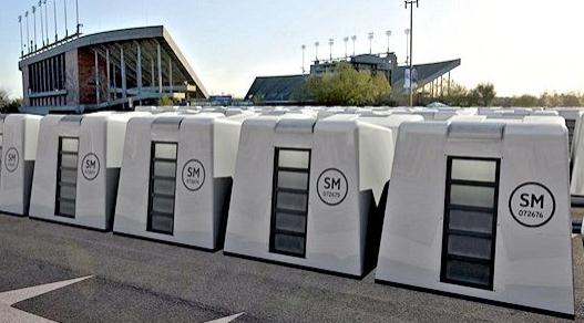
Here's an interesting concept for getting temporary housing to the
scene of hurricane, flood or earthquake survivors who need temporary
homes, as outlined at
gizmag.com: "
In
a world where millions of people are forced from their houses every
year because of natural disasters, there is an ongoing need for huge
numbers of decent mid- to long-term temporary housing units that can be
swiftly delivered to the affected area. The Reaction Housing System has
been developed to make the wait as short as possible."
Apple Has Its Own Killer Maps With Turn-By-Turn Navigation, 3-D, and Tons More. More details on Monday's announcements from Apple courtesy of
gizmodo.com; here's an excerpt: "
As
expected, Apple just announced its own in-house mapping platform at
WWDC. Apple is doing all of the cartography itself, instead of Using
Google Maps, or pulling from an open source format like OpenStreetMap.
One big addition is turn-by-turn navigation in iOS 6, which has been a
big feature that Apple fans have been begging for for years. It'll be
narrated by Siri, of course. It will also be fully integrated with Yelp,
and offer traffic updates, suggesting new routes if traffic is bad
where you're heading. Another cool thing to do is that if you've got to
take two turns back to back, it will show you both of the signs, so you
know what to do."
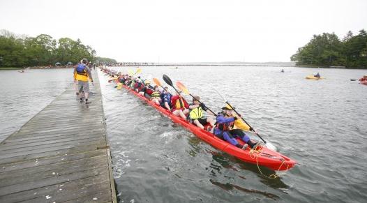
World's Longest Kayak? O.K. It's modular, but I still haven't seen anything quite like this;
gizmag.com has the story: "
After
touring the United States in a bespoke boot-mobile earlier this year,
L.L. Bean has turned its attention to the water in its continuing
centenary celebration. The 100-year-old outfitter has built what it
believes to be the world's largest modular kayak. The bespoke vessel is a
500-foot-long (152 m) version of Point65's collapsible kayak. In its
production form the Point65 Tequila! modular kayak
breaks down into three segments, allowing for easier transport. In
order to build it out to L.L. Bean's 500-foot specification, Point65
adds 98 additional middle sections - because you really wouldn't want to
put a boat that size on your roof rack or trailer."
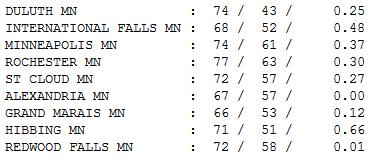
Cooling Off. What a difference - 93 Sunday, almost
20 degrees cooler Monday with HALF as much water in the air, the result
of gusty west/northwest winds pumping Canadian air south of the border.
While we enjoyed a fresh breeze and plenty of sun it rained up north
(.66" at Hibbing and .48" International Falls). Highs ranged from 67 at
Alexandria to 72 St. Cloud, 74 in the Twin Cities and Duluth.
"
Ah summer, what power you have to make us suffer and like it." - Russel Baker
Paul's Conservation Minnesota Outlook for the Twin Cities and all of Minnesota:
TODAY: Fresh air. Perfect, with a hint of mid-September. Dew point: 39. Winds: NW 10-20. High: near 70
TUESDAY NIGHT: Clear, to partly cloudy, still comfortable. Low: 52
WEDNESDAY: Partly sunny, probably dry (T-storms stay west). High: 76
THURSDAY: Sticky, few T-storms likely. Dew point: 65. Low: 62. High: 86
FRIDAY: Hot and steamy, T-storms north/west. Dew point: 69. Low: 68. High: 92
SATURDAY: Tropical, more T-storms. Dew point: 70. Winds: S/SE 10-15. Low: 69. High: 88
FATHER'S DAY: Sunburnt dads. More storms, some strong. Dew point: 70. Low: 70. High: 91
MONDAY: Heavy T-storms, downpours. Low: 69. High: 87
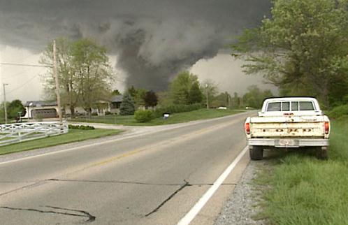
Tornado Tales
Raging wildfires burn out of control out west,
while waterlogged residents of Pensacola, Florida mop up from 21 inches
of rain; two hurricane's worth of moisture. Welcome to 2012, "The Year
of All or Nothing".
I'm always looking for interesting articles for
the weather blog. Todd Krause at the local National Weather Service
office sent me a link that made me do a double-take. New studies show
that if you have a vehicle with multiple airbags you may be safer
staying in your car or truck than diving into the nearest ditch. It's
still somewhat controversial - because a major (EF-3 or higher) tornado
could toss your vehicle hundreds of feet into the air (with a very rough
landing). Your best bet is to find a nearby building, store or rest
stop.
New (connected) vehicles will include Doppler radar, so you know what you're driving into.
Today brings a welcome hint of September, dew
points in the 30s, meaning a third as much water in the air as Sunday.
Soak it up, because highs may brush 90 by late week.
A front stalled just to our west ignites rounds
of T-storms Thursday into Sunday; no all-weekend-washouts but a sticky,
tropical, thundery pattern sets up for Father's Day weekend.
"
The cold passion for truth hunts in no pack". - Robinson Jeffers
Climate Stories...
National Academies of Sciences, National Oceanic and Atmospheric
Administration, American Association for the Advancement of Science,
National Aeronautics and Space Administration (NASA), American Physical
Society, American Geophysical Union, American Chemical Society,
American Meteorological Society, Geological Society of America,
American Institute of Biological Sciences, American Society of
Agronomy, American Society of Plant Biologists, American Statistical
Association, Association of Ecosystem Research Centers, Botanical
Society of America, Crop Science Society of America, Ecological Society
of America, Natural Science Collections Alliance, Organization of
Biological Field Stations, Society for Industrial and Applied
Mathematics, Society of Systematic Biologists, Soil Science Society of
America, University Corporation for Atmospheric Research, Science
Academies of the G8+5 (Canada, France, Germany, Italy, Japan, Russia,
United Kingdom, United States, Brazil, China, India, Mexico and South
Africa), European Academy of Sciences and Arts, Australian Institute of
Physics, and International Union of Geodesy and Geophysics.
-
Scientific societies that acknowledge the reality and danger of human-caused climate change. Source
here.
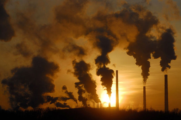
China Emissions Study Suggests Climate Change Could Be Faster Than Thought. Reuters and
The Chicago Tribune have the story; here's an excerpt: "
SINGAPORE/BEIJING (Reuters) - China's
carbon emissions could be nearly 20 percent higher than previously
thought, a new analysis of official Chinese data showed on Sunday,
suggesting the pace of global climate change could be even faster than
currently predicted. China has already overtaken the United States as
the world's top greenhouse gas polluter, producing about a quarter of
mankind's carbon pollution that scientists say is heating up the planet
and triggering more extreme weather."
Research Shows Humans Main Cause Of Global Warming. Radio Australia has more details: "
Scientists
say this is the most comprehensive study to date on global ocean
warming. The research has been published in the journal Nature Climate
Change. The team looked at rising ocean temperatures over the past 50
years, and a dozen models projecting climate change patterns. Australian
based co-author, Dr John Church from Australia's island state of
Tasmania says there's no way all of the world's oceans could've warmed
by one tenth of a degree Celsius without human impact. He says nature
only accounts for 10 per cent of the increase."
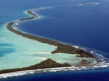
Photo credit above: "
The coastline of Funafuti Atoll, in
Tuvalu. Tuvaluans fear global warming caused by greenhouse gas
emissions, coupled with king tides and cyclones, will render their
nation uninhabitable." [AFP]
Greenhouse Gases Largely To Blame For Warming Oceans: Scientists. Australia's
ABC Network has the story; here's an excerpt: "
Researchers
from America, India, Japan and Australia say the study is the most
comprehensive look at how the oceans have warmed. The study, published
today in the journal Nature Climate Change, examined a dozen different
models used to project climate change, and compared them with
observations of ocean warming over the past 50 years. It found natural
variations accounted for about 10 per cent of rising temperatures, but
man-made greenhouse gases were the major cause."
Photo credit above: "The study says greenhouse gases are largely to blame for ocean warming." David Loh: Reuters.
"Man-Handled". A Decade Ago Conservatives Attacked A Scientist - And Created A Leader. Here's an excerpt from a story written by Chris Mooney for
desmogblog.com: "
I
first became familiar with the name Michael Mann in the year 2003. I
was working on what would become my book The Republican War on Science,
and had learned of two related events: The controversy over the Soon and
Baliunas paper in Climate Research, purporting to refute Mann and his
colleagues’ famous 1998 “hockey stick” study; and a congressional
hearing convened by Senator James Inhofe, at which Mann testified.
Inhofe tried to wheel out the Soon and Baliunas work as if they’d dealt
some sort of killer blow against climate science. In fact, just before
the hearing, several editors of Climate Research had resigned over the
paper. I went on to stand up for Mann, and his work, in Republican War.
Little did I know, at the time, that he himself would become the leading
defender of his scientific field against political attacks."
 Global Warming Threat Seen In Fertile Soil Of Northeastern U.S. Forests
.
Science Daily has the story; here's an excerpt: "
Vast
stores of carbon in U.S. forest soils could be released by rising
global temperatures, according to a study by UC Irvine and other
researchers in a recent online edition of Proceedings of the National
Academy of Sciences. The scientists found that heating soil in Wisconsin
and North
Carolina woodlands by 10 and 20 degrees increased the release of carbon
dioxide by up to eight times. They showed for the first time that most
carbon in topsoil is vulnerable to this warming effect. "We found that
decades-old carbon in surface soils is released to the
atmosphere faster when temperatures become warmer," said lead author
Francesca Hopkins, a doctoral researcher in UCI's Earth system science
department."
Photo credit above: "
UCI doctoral student Francesca Hopkins tested soil in northeastern
forests and found that warming releases carbon locked in the forest
floor into the atmosphere." (Credit: Image courtesy of University of
California - Irvine)
Virginia Republican Forces Scientists To Stop Using "Climate Change" Terminology.
OK. Let's call it "environmental discomfort" from now on. Better yet,
let's ignore the science and just throw caution to the wind. Future
generations won't mind. We did what was in our best interest at the time
- we just thought about ourselves! Sounds like a viable path forward to
me. Amazing details from The Virginian-Pilot and
rawstory.com: "
Virginia House Delegate Christopher Stolle (R)
might be on the right-wing fringe when it comes to climate science,
but at least he’s helping fellow lawmakers temper the tea party’s
reaction to costly government studies on the matter. In a legislative
dust-up earlier this year, according to reporter Scott Harper, writing for The Virginian-Pilot, Stolle told Virginia State Senator Ralph Northam (D)
that the terms “climate change” and “sea-level rise” are “liberal code
words” that must be excised from a study request, or risk having that
request shelved. Shockingly enough: Even though Republicans control the
state’s general assembly and hold the tie-breaking vote in the
Virginia Senate, they voted to approve $138,000 to fund the study after
Northam allowed the term “sea-level rise” to be swapped out for
“recurrent flooding.”
Photo credit: rawstory.com.
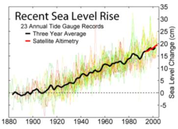
Virginia Says "Sea Level Rise" Is Liberal Propaganda.
We should force this guy to live on the Virginia coast (Norfolk or
Newport News area?) - see if he changes his tune in the years to come.
We're really having an argument about semantics?
Think Progress has more details: "
Virginia’s
legislature commissioned a $50,000 study to determine the impacts of
climate change on the state’s shores. To greenlight the project, they omitted words
like “climate change” and “sea level rise” from the study’s
description itself. According to the House of Delegates sponsor of the
study, these are “liberal code words,” even though they are
noncontroversial in the climate science community. Instead of using
climate change, sea level rise, and global warming, the study uses
terms like “coastal resiliency” and “recurrent flooding.” Republican
State Delegate Chris Stolle, who steered the legislation, cut “sea
level rise” from the draft. Stolle has also said the “jury’s still out” on humans’ impact on global warming."
Climate Change Could Chill International Relations In Arctic. Regina's
Leader-Post has the story; here's an excerpt: "
A
new cold war is on the horizon in international politics, warns a
report co-authored by a University of Saskatchewan researcher. This
cold war is a fight over commercial opportunities in the Arctic, an
increasingly important issue in international relations as climate
change thaws out frozen transportation routes, says the report, Climate
Change and International Security: The Arctic as a Bellwether. "The
Arctic is the first place where we're starting to see the security
impacts of climate change and the geopolitical tensions," said Heather
Exner-Pirot, a researcher with the U of S International Centre for
Northern Governance and Development. "It's about oil and gas. These
weren't accessible before. This would never have been profitable if the
Arctic was still frozen. Now you can go in there with ships."
China Launches Climate Change Think Tank.
Chinadaily.com has the story - here's a snippet: "
China's
newly established national think tank for climate change has put the
"top level design" of China's carbon trading system top of its agenda
agenda. The country officially launched its first national climate
change think tank on Monday — the National Climate Change Strategy
Research and International Cooperation Center — to further strengthen
the nation's research capabilities in addressing climate change. The
center will provide policy decision-making support for climate change
negotiations, advise on low-carbon economic development and cooperate
internationally in this area."
Canada May Warm 2 C by 2020 and 4 C by 2050. A certain amount of warming is already in the pipeline, even if we could magically cut greenhouse gas emissions to zero.
Northumberlandview.ca has the story; here's an excerpt: "
TORONTO, June 11, 2012
/CNW/ - Intact Financial Corporation and the University of Waterloo,
along with more than 80 experts from across the country, today released
the Climate Change Adaptation Project report, which provides a roadmap
for adaptation in Canada. It projects
rising temperatures across the country and substantial fluctuations in
precipitation levels, all of which will leave a range of sectors,
cities and rural regions in Canada
vulnerable. City infrastructure, biodiversity, freshwater resources,
Aboriginal communities and agriculture were targeted as the most
vulnerable areas where adaptive solutions to address climate change are
most urgently required. The report outlines 20 practical and
cost-effective recommendations that can be implemented on a priority
basis in the short term.To guide the project, climate projections for Canada were developed. The results are striking."


No comments:
Post a Comment