20s later today and tonight. As mild as it gets for the next week.
Windchill Warnings likely by Sunday and Monday.
Coldest air in 10 years likely by Monday - probably the coldest of winter.
Moderation likely latter half of January.
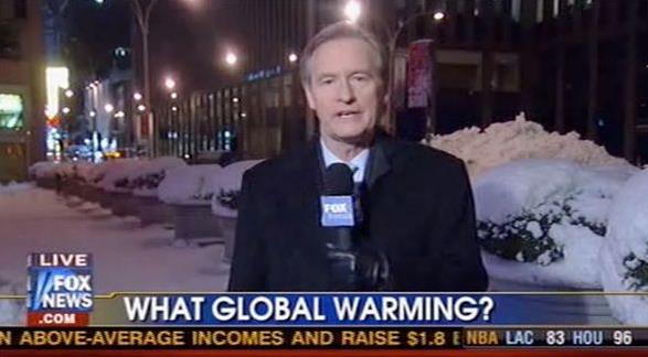
A New Level of Nanook
You know it's bad when they cancel school at International Falls, America's admittedly proud Capital of Cold.
"So
why has it been so persistently cold?" the Star Tribune's Vineeta
Sawkar asked me yesterday. Well, we may as well live in Canada. And
prevailing winds aloft, the jet stream winds we love to babble about,
have been unrelenting, howling from the Yukon for the last month. Most
winters we see more variability - puffs of Pacific air interspersed with
the nasty stuff. Not this winter.
Living in Minnesota we're all
accustomed to cold fronts. But early next week we should experience a
cold-front-on-steroids - a brittle bubble of pain - a black hole of
molecular activity still reeking of Siberian madness. Cars will
complain, schools will close; travel agents may see an uptick in new
business. By my calculations this may be the coldest slap in a decade.
In late January 2004 we saw metro lows as cold as -24F, one day with a
high of -8F. This outbreak will be comparable, maybe a little worse.
Expect
sub-zero temperatures Saturday evening into Wednesday morning, as cold
as -20s in the 'burbs, -30s for St. Cloud and Brainerd.
20s and even a few 30s return for the latter half of January.
Cue the Hallelujah Chorus.
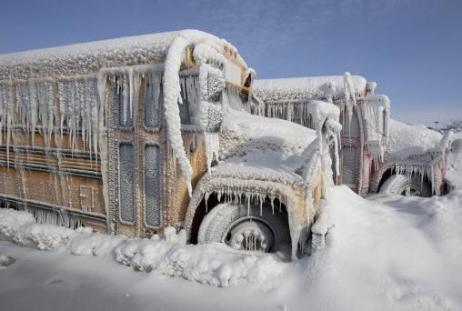
* file photo above: AP
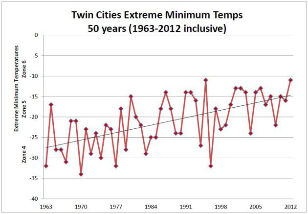
Bucking The Trend?
This seems like a good time to dust off a graphic I use (a lot),
showing a gradual warming of nighttime lows during the winter months in
the Twin Cities. Edina investment banker (and prize rose grower) Jack
Falker created this, using NOAA data for MSP. Since 2000 the coldest
nights of winter have seen lows in the -15 to -23F range; not as cold as
the 60s, 70s and early 80s. I expect a few Twin Cities lows in the -20
to -25F range early next week.
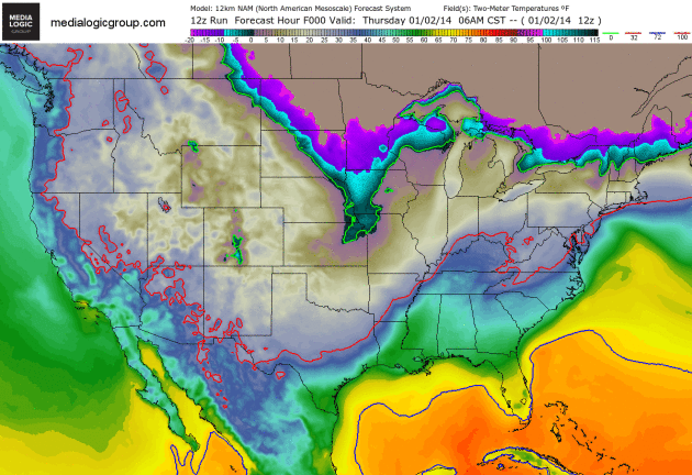
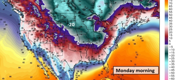
More Than Character-Building.
Here's the 84-hour 2-meter temperatures forecast courtesy of NOAA's NAM
model. The solid red line highlights the 32F isotherm, the solid green
line marks the leading edge of 0F. New colors show up by Sunday and
Monday over the Upper Mississippi Valley. That can't be good. Loop: Ham
Weather.
Some Recovery In Sight.
I hope this isn't a meteorological mirage. GFS data is fairly
consistent showing some moderation by the end of next week, a few 20s
and 30s likely by the third week of January.
Alerts Broadcaster Briefing: Issued Thursday morning, January 2, 2014.
*
The storm that has dumped as much as 16" of snow on the
northern/western suburbs of Chicago is pushing east. Conditions will
rapidly deteriorate this afternoon from Washington D.C. and Baltimore to
Philadelphia, New York and Boston.
* Over 3,700 delays and nearly 1,500 cancellations at U.S. airports so far today. Tomorrow will be worse. Details below.
*
The brunt of the snow (and wind) comes tonight and Friday morning.
Skies will rapidly clear Friday afternoon as the storm accelerates out
to sea, but I expect widespread delays and cancellations tomorrow. Very
cold air in the wake of this storm will make it difficult for road crews
to keep even interstates wet and slushy from late tonight into the
morning hours Friday. I expect rapid improvement on highways and at
major airports Saturday.
* Plowable snowfall amounts are still
likely from Philadelphia and New York City to Albany and Rochester, New
York. This may be a crippling snowfall from Long Island to Cape Cod and
southern suburbs of Boston, where 6-12" of powdery snow will be whipped
into 2-3 foot drifts late tonight and Friday.
This still has the
potential to be a rare (crippling) snow and wind event for coastal New
England and coastal Mid Atlantic communities.
* What may be the coldest air since late January, 2004, is on the way for the northern third of the USA by Monday of next week.
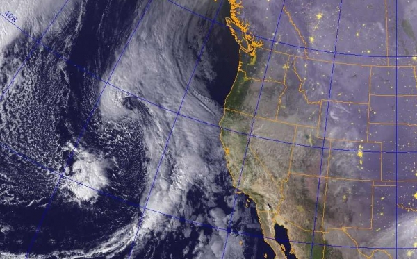
January At Its Best.
We shouldn't be shocked. January is the coldest month of the year
across the USA, and the stronger the surge of arctic air, the higher the
potential for a major storm, spiked with moisture off the Atlantic
Ocean. If it's any consolation the heaviest snows will actually fall
just offshore, brushing coastal sections of the Mid Atlantic region and
New England with enough snow to make it interesting tonight into midday
Friday. Satellite image: NOAA.
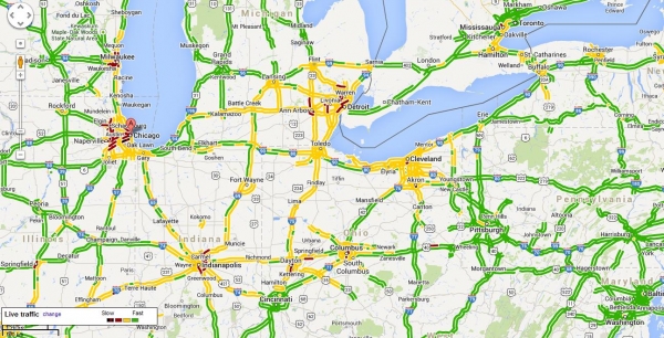
Parking Lot Conditions.
The worst travel right now is from Milwaukee to Chicago, where some
5-15" snowfall amounts were reported, heaviest north/west of The Loop.
Travel by land and air is also a mess in Detroit, Indianapolis, Columbus
and Cleveland this morning. The yellow-shading on the interstates
highlight where roads are currently snow-covered and very slick.
Click here for the latest Google traffic conditions.
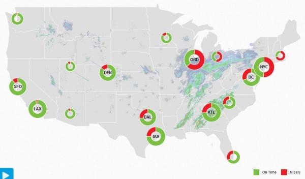
Travel Misery. Here is Flight Aware's "
Misery Map"
showing the airports with the most delays. Chicago's ORD leads the
pack, followed by New York City airports, with significant impacts
rippling to Atlanta and Dallas. At last report over 3700 delays were
reported with nearly
1500 cancellations just today. Tomorrow will be worse.
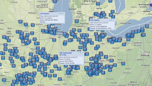
Very Plowable.
Gurnee, north of Chicago, reports 15" of snow, some of it
lake-enhanced. Indianapolis has picked up 5-6" with some 6-7" amounts in
the Detroit area. Map credit: NOAA and
Iowa State University.
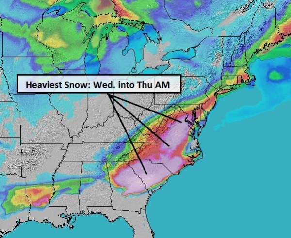
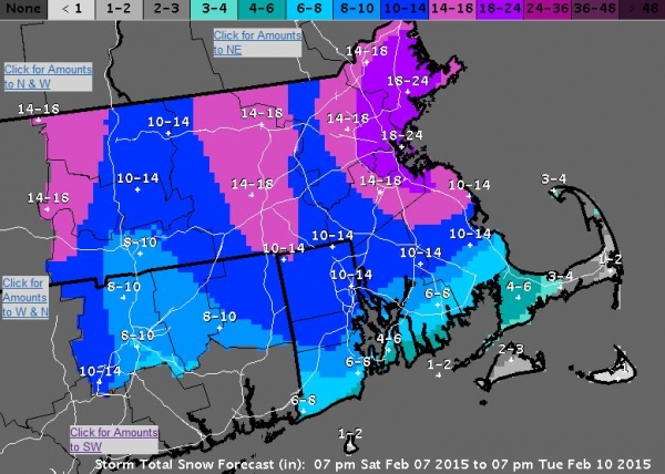
84-Hour Snowfall.
NOAA's NAM model is doing an admirable job of nailing the band of
heaviest snow, setting up from central and northern Indiana to Toledo,
Cleveland and Erie. As the storm approaches the coast Atlantic moisture
will fuel the system, with the heavest amounts forecast from coastal New
Jersey and Long Island to Providence and Cape Cod. It still appears
southeastern Massachusetts, including the islands, will see the most
extreme snowfall amounts - and subsequent blowing/drifting problems
tonight and Friday. Again, this will be a dry, powdery snow, prone to
blowing and drifting as winds gust over 30-40 mph at the height of the
storm. Graphic above: Ham Weather.
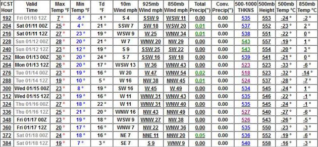
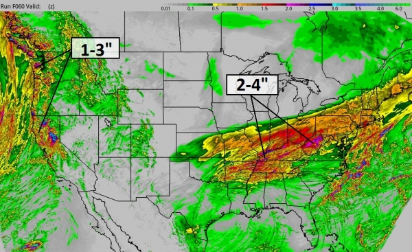
High-Resolution Snowfall Prediction.
To me, looking at all the data and models, this simulation seems
reasonable (wrong word, I know). About 6" for Philadelphia and much of
the Delaware Valley, 2-4" for Baltimore and Washington D.C., closer to
4-8" for New York City,
with 8-10" for parts of Long Island, New Haven, Groton and Hartford -
as much as 10-15" from Newport and Providence to Hyannis and Boston by
midday Friday. RPM model solution courtesy of WSI.
New York City Impacts.
Blizzard Warnings are posted for Long Island, where we still expect the
heaviest snow, strongest winds and lowest visibilities tonight and
Friday morning. Winds may gust to 40-45 mph early tomorrow, creating a
dangerous wind chill of 10 to 15 below. You won't want to be trapped
outside for any length of time tomorrow - the risk of frostbite and
hypothermia very high. Graphic: NOAA.
Boston Impacts.
Blizzard Warnings are up for Cape Cod, where 30-50 mph wind gusts are
possible. Coastal flooding will also be an issue tonight and Friday,
inundating areas within 3-5 feet of sea level. White-out conditions are
possible in Boston for a time Friday morning, and likely over the Cape,
Martha's Vineyard and Nantucket. Map: NOAA.
Latest Warnings.
Winter Storm Warnings are posted for much of the Ohio Valley, the Mid
Atlantic Region (including Philadelphia and Wilmington), all of New
Jersey and most of New England. Blizzard Warnings are in effect from
Long Island to Cape Cod. The worst of the storm comes from midnight
tonight to noon Friday. The latest warnings from NOAA are
here, courtesy of Ham Weather.
The Arctic Mother Lode.
Here we go - what will most likely be the coldest outbreak of the
winter, possibly the coldest air since late January, 2004, is on the way
for early next week. The Upper Midwest, Great Lakes and Ohio Valley
will bear the brunt of this Yukon Invasion, but subzero temperatures
will settle over much of New England, even the Mid Atlantic region, by
Tuesday and Wednesday. Subzero air will impact travel and facilities the
first half of next week, followed by some gradual moderation by the end
of next week. Weather graphic above: Weather Bell.
Summary:
Today's briefing has something for everyone, everything except warmth
and tranquility. The same storm that is slowing air and land travel to a
crawl over the Midwest and Ohio Valley pushes east tonight, with
blizzard conditions possible, especially within 50 miles of the Atlantic
Ocean, late tonight into Friday morning. Travel will continue to worsen
as the day goes on today - I suspect many businesses and schools will
shut down Friday, with gradual improvement on Saturday. Believe it or
not the atmosphere will be warm enough aloft for a period of rain late
Sunday and Monday over the Northeast before brutally cold air arrives
early next week.
Pass the ibuprofen. Good luck, and stay safe out there.
Paul Douglas - Senior Meteorologist - Alerts Broadcaster
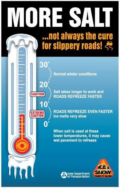
Counterintuitive, But True.
The Iowa Department of Transportation reminds us that spreading more
salt on roads when it's this cold can actually trigger more black ice.
Salt works best when air temperatures are between 20 and 32 F. When it's
this cold salt melts ice very slowly, and may actually cause highways
to refreeze faster than they would with no salt.
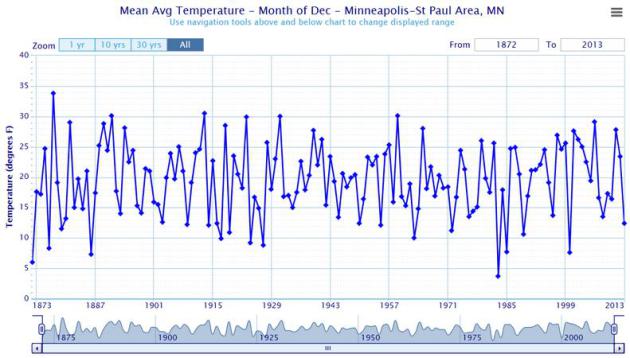
18th Coldest December On Record For MSP.
It was the coldest December since 2000 for the Twin Cities, but we've
seen colder Decembers in years gone by. For St. Cloud it was the 8th
coldest December on record. Details from the
Twin Cities office of The National Weather Service: "
It
was a December to remember in reference to cold weather. However, as
you can clearly see from the long term averages, there have been many
Decembers in the past much colder than December 2013. Even so,
Minneapolis International Airport ended up the month with a respectable
18th place on the all-time list."
1 In 10 Chance Of Major Snowstorm For 2014 Super Bowl?
Apparently there's some controversy over recent statements made by the
New Jersey State Climatologist when asked about a "forecast" for
February 2 at The Meadowlands. Some sports writers confused climatology
with an actual weather prediction for the day in question. Here's an
excerpt of a story at
NJ.com: "...
Based
on an analysis of 80 years of data gathered at Newark's weather
station, which is the closest long-term station to MetLife Stadium, we
found there's a one out of 10 chance based on past records that it snows
during the evening hours of Feb. 2. The record suggests that the
largest snow event in the last 80 years on Feb. 2 at Newark is 3.2
inches..."
2013's Wild, Unforgettable Weather: A Roundup.
LiveScience has the highlights and lowlights of a fairly quiet year, overall, for the USA, with a few notable exceptions: "
Floods,
fires and typhoons — weather fueled by heat led the news in 2013. In
Colorado and central Europe, tropical moisture fed heavy rains and
floods. Australia was ravaged by heat waves and wildfires for much of
the year. Warm Pacific Ocean temperatures fueled major tropical storms
that devastated the Philippines and Asia. The unusually warm
temperatures are on pace to set a heat record, making 2013 one of the
warmest years in more than a century, according to a report released in
December by the National Climatic Data Center (NCDC). The first 11
months of 2013 are the fourth warmest (averaged around the globe) since
record-keeping started 134 years ago..."
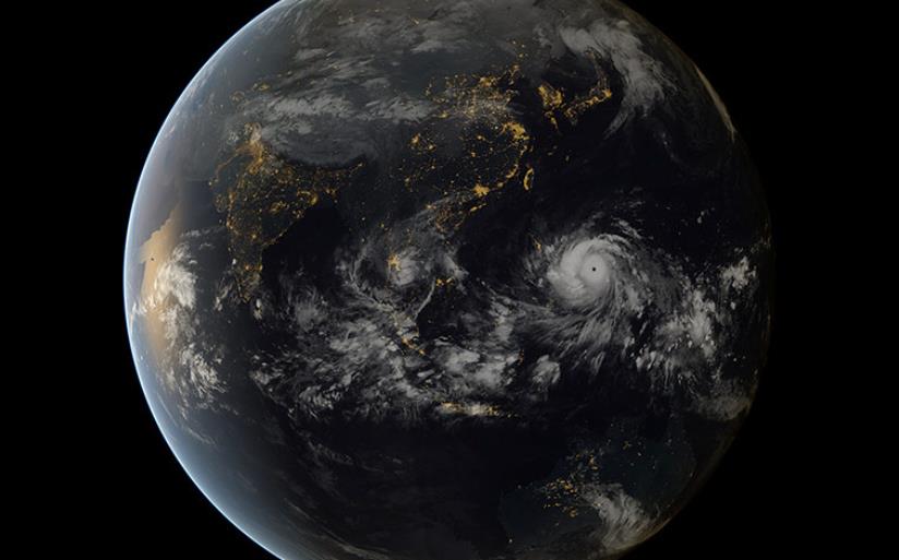
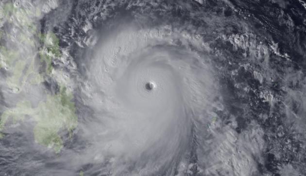
Image credit above: "
Super
Typhoon Haiyan, the strongest storm seen during the satellite era, was
spotted by the Japan Meteorological Agency's MTSAT on Nov. 7, 2013, as
it headed toward landfall over the Philippines." Credit: Japan Meteorological Agency/NOAA.
Compared To 2 Previous Years, 2013 Was A Paper Tiger.
Meteorologist Andrew Freedman has a good summary of what was a
relatively quiet year for the USA, at least compared to the insanity of
2011 and 2012; here's an excerpt from Climate Central: "
The U.S. suffered its share of extreme weather and climate events in 2013, from a monster tornado
that flattened large parts of Moore, Okla., to the driest year on
record in California. But compared to the blockbuster calamities of the
previous 2 years, 2013 stands out more for its relative tameness. Mother
Nature’s most powerful storms — hurricanes — were unusually absent
from the North Atlantic. Not a single hurricane made landfall in the
U.S., and no major hurricanes of Category 3 or above intensity even
formed. In addition, the longstanding drought that had gripped much of
the nation abated. And for the first time in 20 years, daily record low
temperatures outnumbered daily record highs..."
Climate Central Infographic featured above is
here.
 2013 In Review: Extreme Weather - In Pictures
. Here's an excerpt of a 20 slide recap of some of the more unusual and extreme weather events of 2013, courtesy of
The Guardian: "
2013
was the seventh warmest year on record and saw one of the strongest
cyclones, some of the longest heatwaves and the most topsy-turvy weather
experienced in decades."
Image credit above: "
On
7 November typhoon Haiyan made landfall in Guiuan, Eastern Samar, in
the Philippines, with sustained winds of 145-195mph, by some measures
the most powerful storm on record to strike land. This composite of
satellite images shows the fearsome size of Haiyan as it headed towards
the Philippines."
Photograph: Japan Meteorological Agency and EUMETSAT/Barcroft Media.
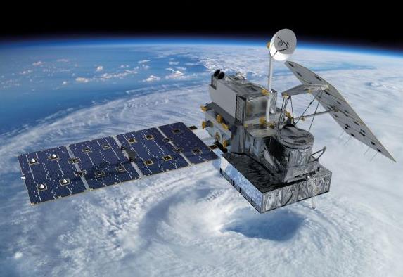
Weather Forecasting Is About To Improve With Satellite Launch.
The launch of a new low-orbiting satellite may help the initialization
of global weather models, the quality of data we put into the
simulations that drive weather forecasts. Here's an excerpt from
Global Post: "
NASA and the Japan Aerospace Exploration Agency announced the launch of a precipitation satellite that will enhance how we understand the climate.
The Global Precipitation Measurement Core Observatory satellite will be
launched on February 27 from Japan's Tanegashima Space Center and will
measure precipitation and energy cycles. Researchers say that it will
improve weather forecasting worldwide. "Launching this core observatory
and establishing the Global Precipitation Measurement mission is vitally
important for environmental research and weather forecasting," said Michael Freilich, director of NASA's Earth Science Division in Washington..."
Image credit above: "
Artist concept of the Global Precipitation Measurement (GPM) Core Observatory satellite." (NASA/Courtesy).
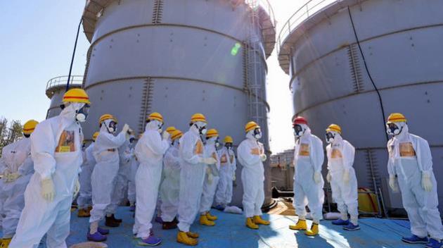
Mystery Steam Over Fukushima Could Be Sign Of Another Meltdown.
Gizmodo has the story - here's a clip: "
The newest update in the highly disconcerting series of devastating failures that is the Fukushima cleanup effort is troubling to say the least. Tepco has confirmed
that (unexplained) plumes of steam have been rising from the mangled
remains of Reactor Building 3. In other words, there's a chance
Fukushima could be in the middle of another meltdown. The thing is, no
one has been able to find out the exact cause of the rising, mysterious
radioactive steam because the combination of physical damage and, more
importantly, lethal radiation levels have made investigating the reactor
impossible..."
2013: The Year In Science. The techno-geeks at
Gizmag take a look; here's an excerpt: "
The
close of 2013 gives us an excellent opportunity, though satiated with
holiday feasts, to look back on a year that has been filled with
scientific accomplishment. So it's time to get comfortable on your Binary Chair, sip your hot cocoa from a phase-change mug while your Foodini prints out a batch of cookies and reflect on science stories of note from the past year..."
This Dumb Year: The 47 Lamest Moments In Tech, 2013.
Time Magazine has a good run-down of some of the more head-slapping moments of last year; here's the intro: "
In tech, dumb moments come in an array of flavors — but some years have definite overarching themes. 2012, for instance, was the year of the apology.
And 2013 turned out to be the year that proved human beings shouldn’t
be allowed to use Twitter. Or at least it kept feeling that way.
Everybody kept tweeting stuff they probably came to regret. Celebrities
such as BlackBerry Global Creative Director Alicia Keys, whose only
mistake was tweeting from an iPhone (unless, as she said, the tweet came
from an iPhone-using hacker). People we never heard of until they
embarrassed themselves on Twitter and got fired, including Business
Insider’s CTO, IAC’s PR honcho and a producer of The Bachelor. Even
beloved American institutions such as AT&T and SpaghettiOs..."

Tips For A Successful Digital Detox.
Step away from the smartphone please. If you're finding it increasingly
difficult to keep up with e-mails, FB posts, tweets, etc - here are a
few suggestions from
Shape Magazine: "
Chances
are your smartphone is within arm’s reach right now, if you’re not
already using it to read this. We’re spending more time than ever on our
digital devices—anywhere from one to two hours daily, depending on
which study you consult—and with the flood of incoming texts, emails,
calls, and push notifications, it’s rare if our screens stay dark for
more than a moment. While there’s no doubt technology has made our lives
easier in many ways (remember roadmaps?), research suggests that our
addiction to it is real. “Every new notification or text triggers the
release of dopamine, a neurotransmitter that drives us to seek rewards,
so you keep coming back for more," explains Levi Felix, co-founder of Digital Detox and Camp Grounded, which run tech-free weekend getaways for adults..."
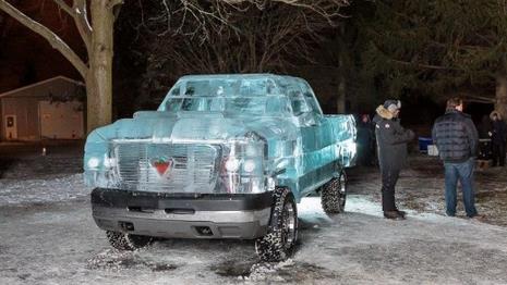
Canadian Tire Ice Truck Redefines Cold Weather Driving. I suspect many of us will have vehicles that resemble this by early next week - details from
gizmag.com: "
With
Eastern Canada experiencing one of the worst ice storms in recorded
history, the idea of an ice truck might seem overtly ironic to some. The
ice sculpting house of Iceculture and Canadian Tire, however, already
had their 15,000 lb ice truck planned, built and ready to go before the
storm hit..."
This Amazing Dog With A Mustache Deserves Your Complete Attention.
Yes, "before we go" let's admire this little pooch with a perfectly
natural mustache. I wish I could grow one that good. Details in this
amazing pictorical from
Buzzfeed.
FRIDAY: Mostly cloudy, almost tolerable. Winds: S 20+ High: 23
FRIDAY NIGHT: Clouds and flurries. Temperatures holding in the 20s.
SATURDAY: Flurries, turning windy and colder. High: 20 (early) falling into single digits by afternoon.
SUNDAY: Sunny, unreasonably cold. WC: -30. Wake-up: -16. High: -8
MONDAY: Little Siberia. Dangerously cold. Wake-up: -24. High: -10
TUESDAY: Still subzero. Call travel agent. Wake-up: -20. High: -2
WEDNESDAY: Mostly cloudy. A little better. Wake-up: -10. High: 13
THURSDAY: Some feeling returns to extremities. Patchy clouds. Wake-up: 9. High: 22
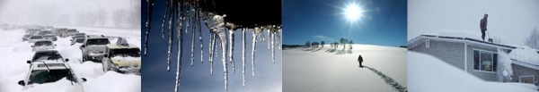
* photo credit above: Imara Hixon.
Climate Stories...
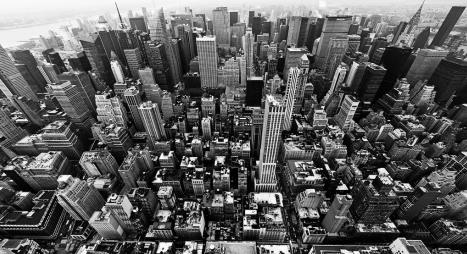
On Defense: Cities Get Serious About Climate Resilience In 2013. Sandy
was a 2 by 4 across the head for New York City, but other cities are
waking up and taking steps to counter a more volatile climate. Here's an
excerpt from
Grist: "...
Sandy
was the second major storm to plow through New York in as many years,
and as we learned during our retrospective this fall, it wasn’t even the long-feared Big One. Sandy ricocheted into the coast. A direct hit, which will no doubt come eventually, will be much worse, particularly as warmer seas whip up more powerful storms, and rising sea levels bring them to more of our doorsteps. This year saw more weather extremes, including biblical floods that swept away houses, roads, and bridges in Calgary, Alberta, and Boulder, Colo., a heatwave in Alaska, bitter cold in Florida, and a monstrous typhoon that wreaked massive havoc in the Philippines, killing more than 6,000 people. It’s impossible to blame climate change alone for any of these events, of course, but it certainly made many of them worse, and science tells us they’re signs of things to come..."
Photo credit above:
Andrew Ferguson.
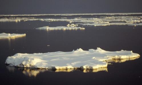
Five Basic Antarctic Facts For Climate Change Skeptics. The Guardian
has some perspective on the "warmist" ship that recently got caught in
Antarctic ice, leading to the evacuation of those onboard. Here's an
excerpt: "
To most people the prolonged stranding of the MV Akademik
Shokalskiy in thick pack ice off the coast of Antarctica is an
unfortunate incident that provided passengers with rather static scenery
for their Christmas and New Year celebrations. But to some climate
change contrarians, repeated attempts to free the vessel from the ice
are proof that the theory of climate change is flawed or, at best,
exaggerated. After all, a warming planet has no ice at all, right? In
Sydney’s Daily Telegraph, Roger Franklin dispensed with analysis of ice
extent, the cyrosphere and the like to get to the heart of the matter
– expedition leader Chris Turney is a “warmist” whose understanding of
Antarctica amounts to little more than it gets “really, really cold”...
Photo credit above: "
The
Intergovernmental Panel on Climate Change says there is "high
confidence that ice shelves around the Antarctic peninsula continue a
long-term trend of retreat and partial collapse". Photograph: AAP.
Kerry Shifts State Department Focus To Environment. Will the administration be able to move the needle? Here's an excerpt from a
New York Times article: "...
But
while the public’s attention has been on his diplomacy in the Middle
East, behind the scenes at the State Department Mr. Kerry has initiated a
systemic, top-down push to create an agencywide focus on global
warming. His goal is to become the lead broker of a global, legally
binding climate treaty in 2015 that will commit the United States and
other nations to historic reductions in fossil fuel pollution. Whether
the secretary of state can have that kind of influence remains an open
question, and Mr. Kerry, despite two decades of attention to climate
policy, has few concrete accomplishments on the issue..."
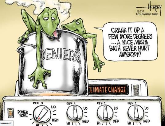
Crank It Up. Cartoon courtesy of
David Horsey at The Los Angeles Times.
Climate Change Models Underestimate Likely Temperature Rise, Report Shows. Here's an excerpt from
The Guardian: "
The
Earth’s climate is far more sensitive to carbon dioxide emissions than
previously thought, heightening the likelihood of a 4C temperature rise
by 2100, new Australian-led research of cloud systems has found. The
study, published in Nature,
provides new understanding on the role of cloud formation in climate
sensitivity – one of the key uncertainties in predictions of climate
change. Report authors Steven Sherwood, Sandrine Bony and Jean-Louis Dufresne
found climate models which show a low global temperature response to
CO2 emissions do not factor in all the water vapour released into the
atmosphere..."
Photo credit: "
Understanding cloud formation is key to predicting climate change." Photograph: CBW/Alamy.
Climate Change: Planet To Warm 4C By 2100.
Following up on the latest research into cloud dynamics and possible
impact on warming here's an excerpt of a slightly different perspective
from
The Sydney Morning Herald: "...
Forecasts
in many climate models for lower temperature rises were based on
assumptions that clouds might help limit temperature increases. But the
team claims to have found the key to predicting cloud behaviour, and
forecasts that clouds will not be nearly as helpful as thought in many
models. Current models estimate a doubling of carbon dioxide in the
atmosphere - a level that may be reached by mid-century - will result in
temperature rises of between 1.5 degrees and 5 degrees. Instead, the
likely range will be 3-5 degrees for twice the amount of C02, the study
found..."
Photo credit above: "
New research suggests temperatures will rise between 3-5 degrees for a doubling of C02." Photo: Michael Clayton-Jones.
13 Dumbest Things Said About Climate Change In 2013.
Media Matters has the story (and video).


Joshua vs Povetkin
ReplyDeleteJoshua vs Povetkin Live
Joshua vs Povetkin Live Stream
Joshua v Povetkin
Joshua v Povetkin Live
Povetkin vs Joshua
Povetkin vs Joshua Live
Povetkin v Joshua
Joshua vs Povetkin
Joshua vs Povetkin Live
Joshua vs Povetkin Fight
Joshua v Povetkin
Povetkin vs Joshua
ReplyDeleteCanelo vs Rocky
Canelo vs Rocky Live
Canelo vs Rocky Live Stream
Rocky vs Canelo
Canelo vs Fielding
Canelo Alvarez vs Rocky Fielding
Canelo Alvarez vs Rocky Fielding
Canelo Alvarez vs Rocky Fielding Live
Rocky Fielding vs Canelo Alvarez
Canelo vs Rocky
Oscars
ReplyDeleteOscars Live
Oscars 2019
Oscars 2019 Live
91st Oscars
Academy Awards
Oscar Awards
Oscar Live
Oscars
Oscars Live
Oscars 2019
Oscars 2019 Live
91st Academy Awards
Oscar Awards
The Oscars are here. Which movie will be the big winner when the statuettes are handed out this Sunday, February 24, 2019, starting at 8pm EST?
ReplyDeleteOscars Live
Oscars 2019
Oscars 2019 Live
91st Oscars
Academy Awards
Oscar Awards
Oscars
Oscars Live
Oscars 2019
Oscars 2019 Live
Academy Awards
Oscar Awards