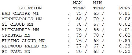
80 F. high in the Twin Cities yesterday.
84 F. average high on July 12.
90 F. high on July 12, 2013.
.06" rain fell at MSP International Airport Saturday.
Big Variations in Saturday Rainfall.
Although only .06" fell at Richfield, St. Paul reported half an inch,
with .81" at Eau Claire and .83" rain reported at Eden Prairie.
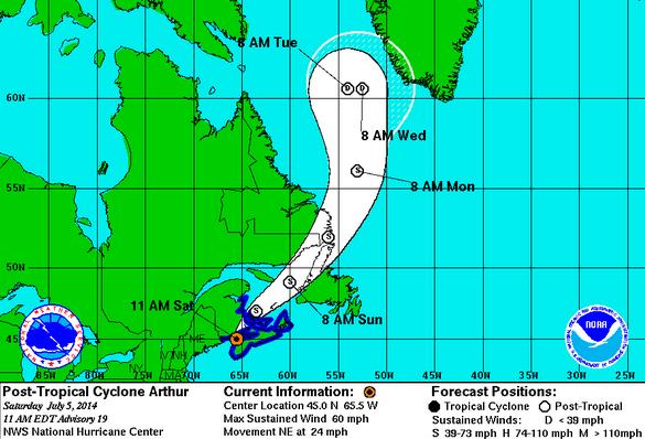
Arthur's Revenge?
Historically
we are now entering the hottest week of the year. MSP average highs
plateau at 84F between July 6-21. We SHOULD be in the 90s. I SHOULD be
babbling about dew points, heat indices and hot weather safety tips.
Instead
I'm checking the furnace, digging my favorite Twins sweatshirt out of
cold storage and debating whether including Monday's forecast wind chill
is a smart career move. Answer: probably not. A wind chill in July?
That's a new one.
One theory that could have merit: Hurricane
Arthur may have dislodged a chunk of unusually chilly air over James Bay
as it howled into Canada's Maritimes last week. Much like powering up a
snow blower in your attic throws debris into the family room, intense
counterclockwise winds howling into eastern Canada disrupted an already
fickle & unstable jet stream, now bulging southward with chilly
implications.
We cool off today; tomorrow will feel like any other
October 7; a wind chill in the 50s. I'm so sorry. Tuesday's MLB
All-Star Game should be the chilliest on record. I wouldn't be surprised
to see the Vikings or Gophers take the field.
Our weather has become a Meteorological Bizarro World.
What's next? I wish I knew.
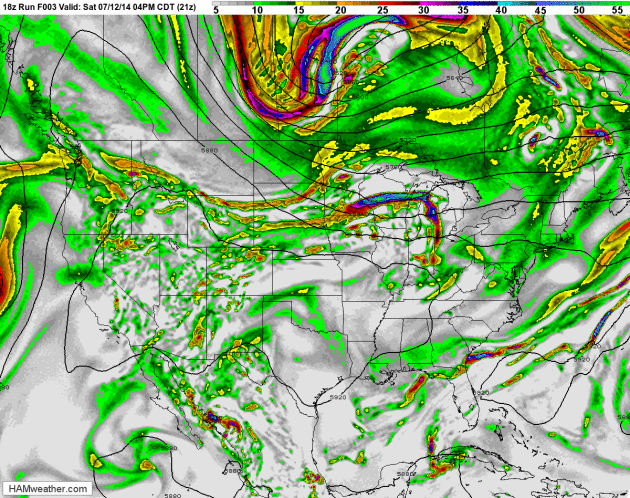
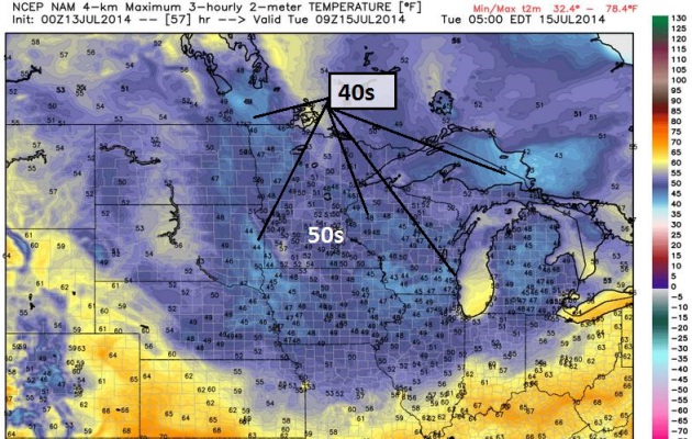
500 mb Winds: Typical for Early October.
Jet stream winds buckle, plunging record chill unusually far south into
the Upper Midwest and Great Lakes. While the western USA and Canada
fries with highs well up into the 90s, even some 100s. Yes, this is
unusual for mid-July, historically the warmest period of the entire
year. 84-hour NAM 500 mb winds and vorticity: NOAA and HAMweather.
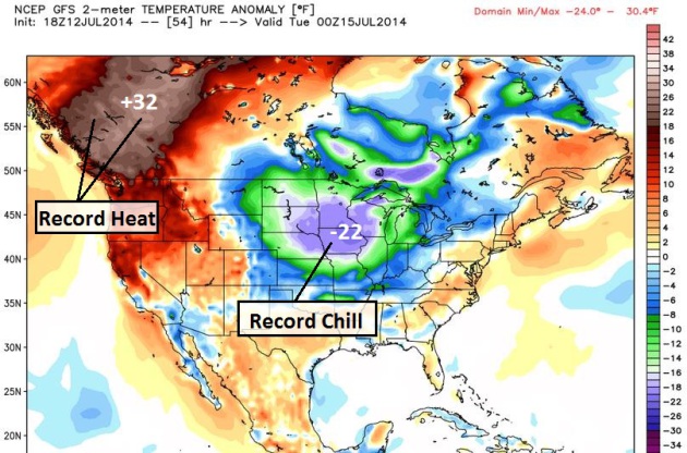
A New Level of Weather Extremes.
Temperature anomalies Monday evening may be 20-24F cooler than average
from the Twin Cities to Des Moines and Madison, while readings 30-35F
warmer than average bak much of western Canada, sparking a rash of
records. I can't remember (ever) seeing these kinds of extremes in July,
at least going back to the early 70s. Map: Weather Bell.
Tuesday Morning: Furnace-Worthy.
Where are those sweatshirts I stashed into cold storage back in early
May? Get ready for a fleeting time warp, Tuesday wake-up temperatures
ranging from mid 40s to low 50s. I wouldn't be shocked to hear of a few
frost reports near Embarrass and Tower by Wednesday morning. Map:
Weather Bell.
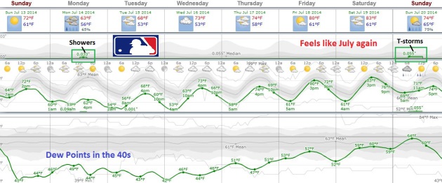
This Too Shall Pass.
Extended weather data from the ECMWF model shows showers Monday with a
chill factor (again, my apologies) dipping into the low and mid 50s.
We'll set a record Monday for the coldest July 14 daytime high, dating
back to 1871. Game time temperatures will be in the low to mid 60s for
Tuesday evening's MLB All-Star Game, probably the coolest All-Star
baseball game ever played. Dew point drop into the 40s, typical for late
September and early October, before summer returns by the end of the
week. Meteogram: Weatherspark.
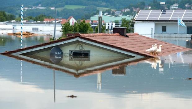
Sandbags on 'Tonka.
Saturday evening I noticed a number of homes still have sandbags on
their shoreline, something I've never (ever) seen before. The water
level has come down a bit, maybe an inch or two, but at the rate we're
going no-wake restrictions may not come off Lake Minnetonka until late
July or even early August.
Four Weather Events in History Mistaken For The Apocalypse. One of them, according to this interesting story at
AccuWeather.com, was 1816, the "Year Without a Summer". Here's an excerpt: "...
As
the weeks continued, the icy winter spell would linger for the
remainder of the summer, causing an immense burden on farmers across the
country. "On July 4, water froze in cisterns and snow fell again, with
Independence Day celebrants moving inside churches where hearth fires
warmed things a mite," Virginia resident Pharaoh Chesney is quoted by
the Smithsonian Magazine. "Thomas Jefferson, having retired to
Monticello after completing his second term as President, had such a
poor corn crop that year that he applied for a $1,000 loan," the article
reported..."
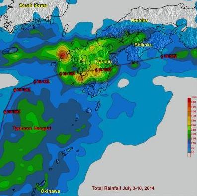
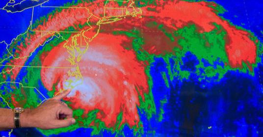
NASA's TRMM Satellite Maps Tropical Storm Neoguri's Soggy Path Through Japan. Satellite-derived rainfall estimates - pretty cool, and surprisingly accurate. Here's an excerpt from
Science Codex: "...
Southern
Japan received a soaking from Tropical Storm Neoguri on July 9 and 10
and data from the TRMM satellite was used to create a map that shows how
much rain fell in Kyushu. Kyushu is the southwestern most and third
largest island of Japan. The island is mountainous and is home to Mount
Aso. Heavy rainfall from Neoguri fell on land that was already soaked in
the past week from a slow moving frontal system..."
Image credit above: "
This
rainfall analysis using TRMM satellite data showed that rainfall totals
of over 490 mm (19.3 inches) fell in western Kyushi over the period
from July 3-10, 2014.The red line indicates Tropical Storm Neoguri's
track." (Photo Credit: Text : Hal Pierce / Rob GutroImage : SSAI/NASA, Hal Pierce).
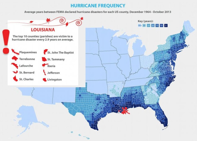
So What Do You Know About Hurricanes? Metro Jacksonville has a terrific infographic with a few surprises: "
Considering
it's hurricane season, Metro Jacksonville shares a Global Data Vault
infographic featuring data provided by the Federal Emergency Management
Agency (FEMA)."
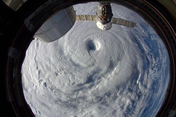
NASA Spots a Super Typhoon.
National Geographic has a post about "Neoguri", captured by the ISS, The International Space Station: "
Watch out, Japan!" said European Space Agency astronaut Alexander Gerst after taking this July 7 picture
of Supertyphoon Neoguri from the International Space Station. The
supertyphoon lashed Okinawa this week, and at the time the photo was
taken, was producing 150-mile-an-hour (240-kilometer-an-hour) winds..."
Photograph by Alexander Gerst, ESA/NASA.
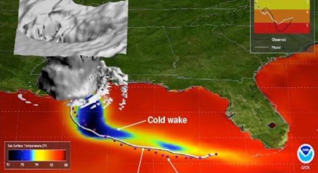
Upgraded HWRF and GFDL Hurricane Models Excelled During Hurricane Arthur. Weather Underground has a good summary of how NOAA's enhanced, recently upgraded high-resolution models just performed; here's an excerpt: "
The
landfall last week of Hurricane Arthur, the first named tropical system
in the Atlantic for 2014, brought a quick start to this year’s
hurricane season. Perhaps lost in the predictions and preparations for
Arthur’s landfall was the fact that there have been major upgrades this
year to the two operational National Weather Service (NWS)
regional hurricane prediction systems, the GFDL and HWRF models. Here
we will provide background on each of those models and highlight the
forecast improvements achieved from recent upgrades to both models..."
Image credit above: "
Inner
core structure of Hurricane Katrina of 2005 simulated from the GFDL
hurricane forecast model. Sea Surface Temperatures (SST) are denoted by
the color shading, with the darker colors of blue showing the cooling of
the SSTs due to the hurricane winds mixing the cooler waters from below
to the surface."
Study Provides New Approach to Forecast Hurricane Intensity.
Predicting hurricane intensity is much more challenging than
forecasting track; here's an excerpt of a story focused on new research
from
The University of Miami: "
New
research from University of Miami (UM) Rosenstiel School of Marine and
Atmospheric Science suggests that physical conditions at the air-sea
interface, where the ocean and atmosphere meet, is a key component to
improve forecast models. The study offers a new method to aid in storm
intensity prediction of hurricanes. “The general assumption has been
that the large density difference between the ocean and atmosphere makes
that interface too stable to effect storm intensity,” said Brian Haus,
UM Rosenstiel School professor of ocean sciences and co-author of the
study. “In this study we show that a type of instability may help
explain rapid intensification of some tropical storms...”
Data and Analytics Try To Limit Hurricane Damage. Dell Computer
has an interesting guest post about the power of analytics and models
to get a better handle on which communities in Hurricane Alley are most
vulnerable, and how much cash to set aside for a rainy (windy) day.
Here's a clip: "...
With every new hurricane that makes landfall in
the U.S., advanced catastrophe modeling and analytics allow
property-casualty carriers to more accurately price a homeowners
insurance policy. Models also help insurance carriers
calculate the amount of capital they need to set aside in reserve to
pay claims and how many catastrophe insurance policies insurers can
afford to reinsure. Catastrophe models help insurance companies plan
ahead and serve as a tool that contributes to the industry allocating
capital more efficiently, Larsen says..." (File image: EPA).
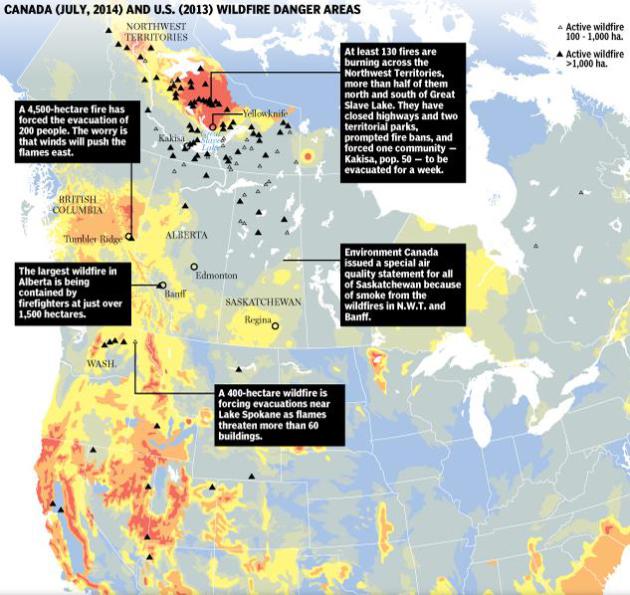
Graphic: Wildfires Raging in North America. Canada's
National Post
has a terrific infographic and explainer, pinpointing all the wildfires
across North America. Smoke from the 100+ blazes burning in Canada's
Northwest Territories has been sweeping southward into the USA in recent
weeks. Here's a clip: "
Hundreds of wildfires are raging in British
Columbia, Alberta, Quebec and the Northwest Territories while the U.S.
is battling large blazes in Arizona, Nevada, Utah, Idaho, California,
Colorado, Florida, Washington state and New Mexico. Canada has already
had more than 2,000 wildfires this year. And this week saw U.S.
President Barack Obama ask Congress for $615-million to help fight the
fires this season. So where are the hotspots in North America and how do
those fires start and spread?"
What Is Causing The Kidney Stone Epidemic? Staying hydrated in the (increasing) heat is everything; here's an excerpt from
io9.com: "
Pediatric
urologist Gregory Tasian and his team analyzed over 60,000 medical
records of people with kidney stones in major cities throughout the U.S.
What they found was that people were more likely to develop the painful
calcium deposits (pictured above) in their kidneys when average
temperatures rose over 50 degrees. In fact, many cases of kidney stones
cropped up roughly three days after a hot day. Now that climate change
means that some regions of the globe are heating up, it's likely that
kidney stones will become even more common..."
Car Insurance Companies Want to Track Your Every Move - And You're Going to Let Them.
If you want the lowest possible rate you give up a little more of your
privacy (and soul) right? Here's the intro to a story at
Quartz: "
The
proposition is simple: Install a device in your car and allow your
insurance company to monitor your driving—how fast you drive, how hard
you brake, how sharply you corner, and so on. In exchange, it will give
you a discount on your premiums. That
might sound alarming, but it shouldn’t
be surprising. Considering internet users already happily trade data on
every online move they make in exchange for free services, the only
surprise is tracking-based insurance isn’t already more widespread..."

Say It Isn't So - World's Largest Mall Slated for Dubai.
It should be noted that Dubai already has 52 malls, each with it's own
magazine. Because they do BIG THINGS in Dubai. Maybe our Mall of America
can expand into MSP International to keep us in the hunt. Gizmag has more details: "...Dubai
Holding hasn't revealed firm dates nor a budget for the project yet,
but we do know some basic information. It comprises 743,224 sq m (8
million sq ft) of floorspace, which makes it easily the largest mall in
the world, a shade larger than China's Forbidden City, and about four
times the size of France's Louvre Palace..."
Every State in the USA, Ranked by it's Food/Drink. Minnesota ranked 23rd out of 50 states. Really? Here's an excerpt of a sure-to-be-controversial story at
Thrillist: "...
Surly’s was at the forefront of a damn fine brewing scene, but really this ranking is about the glorious innovation that is the Juicy Lucy.
Any chump can melt cheese ON a burger, but it takes vision to put it
INSIDE the burger. For such achievements you get a pass on that
suspect-looking hot dish stuff..."
Amazon Asks FAA For Permission to Fly Drones. Some-day delivery within 30 minutes? Like a vending machine in the sky.
The Associated Press has the story; here's a clip: "...
In
a letter to the FAA dated Wednesday, Amazon said it is developing
aerial vehicles as part of Amazon Prime Air. The aircraft can travel
over 50 miles per hour and carry loads of up to 5 pounds. About 86
percent of Amazon's deliveries are 5 pounds or less, the company said.
"We believe customers will love it, and we are committed to making Prime
Air available to customers worldwide as soon as we are permitted to do
so," Amazon said in the letter..." (Image credit: amazon.com).
TODAY: Partly sunny, comfortable breeze. Dew point: 55. High: 75
SUNDAY NIGHT: Partly cloudy, chilly for mid-July. Low: 55
MONDAY: Record chill. Raw, windy & showery. High: 62 (record cold max temperature: 68F in 1884)
TUESDAY: Football weather with more clouds than sun. Take a sweatshirt for the All-Star Game. Wake-up: 52. High: 68
WEDNESDAY: Sunny. Less October. More September. Wake-up: 50. High: 73
THURSDAY: Sunny and milder, still comfortable. Dew point: 49. Wake-up: 58. High: 79
FRIDAY: Feels like July again. Warm sunshine. Wake-up: 61. High: 83
SATURDAY: Warm sun, nighttime T-storms. Wake-up: 66. High: 84
Climate Stories....
Adapting to Climate Change: Let Us Consider the Ways. Breaking news: we're already being forced to adapt to a warmer, more volatile climate.
ScienceNews has the Op-Ed; here's an excerpt: "...The title of the report, “
Climate
Change Adaptation,” sounded familiar. That’s because it was very
similar to the working title of this issue’s cover story. And although
our article deals with the feathered and flowered worlds of plants,
animals and other creatures — and not military
infrastructure — biologists are similarly concerned with how natural
populations might respond to the consequences of climate change. The
feature “Quick change artists” tells an important story about some of the ways that vulnerable organisms might adapt to a changing world..." (Image: Shutterstock).
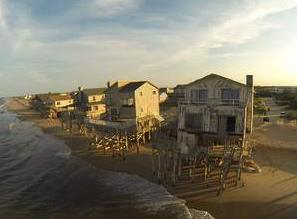
North Carolina's Outer Banks "Ban" Rising Seas.
Many people in Europe think we've lost our minds on this side of the
pond, at least when it comes to science. Here's a clip from a story at a
radio station in the U.K. that caught my eye: "...
An
overwhelming majority of scientists predict sea levels will rise by at
least a metre up and down the coast of the US by 2100. One of them is
Professor Orrin Pilkey, Professor Emeritus of Earth and Ocean Sciences,
at Duke University in North Carolina. He says the people of the Outer
Banks and their politicians are living in denial. It is impossible, he
says, for politicians simply to legislate that a scientific prediction
should be ignored. "All up and down the East Coast, Gulf Coast and West
Coast it's all the same and still they stick their heads in the sands,"
he says..."
No Magic Bullet for Climate Change, Swiss Scientist Says. No silver bullet, but plenty of silver buckshot.
The Boston Globe has the article; here's an excerpt: "...
The
lesson, says Lino Guzzella, president-elect of the renowned Swiss
university known as ETH Zurich, is we cannot expect technological
discoveries like those conceived by Einstein to save us from the pain of
climate change. “We cannot sit and fold our hands waiting for a new
technology. If we have to wait until the next Einstein comes, it won’t
do,” says Guzzella. “The problems we are talking about need to be
tackled with the existing tools we have...”
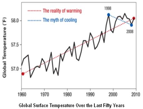
"But There's Been No Warming Since 1998!"
Global surface temperatures have plateaued, but the oceans continue to
warm, in fact more than 90% of all warming is going into the world's
oceans. Here's an excerpt from
The Union of Concerned Scientists: "..
.Focusing
on relatively short time periods to claim global warming is not
happening is a misleading way to use statistics. These false claims have
become so persistent that late last year the Associated Press asked a
team of independent statisticians to review global temperature data
without revealing to them what the data represented.[5] All of the statisticians concluded that the data showed an unmistakable upward trend over time..."
In Las Vegas Climate Change Deniers Regroup, Vow to Keep Doubt Alive. Bloomberg Businessweek has the story; here's the introduction: "
Earlier
this week, the Heartland Institute convened its Ninth International
Climate Change Conference in Las Vegas. A nonprofit, free-market think
tank in Chicago with a $6 million annual budget, Heartland has been
hosting conferences since 2008 for those dubious of the science
confirming human-caused climate change. It is called the ICCC for short,
the acronym an intentional echo of the IPCC, the Intergovernmental
Panel on Climate Change, an international body that has published the
most comprehensive studies of global warming..."
Image credit above: Chester Higgins Jr./The New York Times via Redux. "The Greener Horizon booth at the 2009 International Conference on Climate Change."


No comments:
Post a Comment