26 F. high in the Twin Cities Tuesday.
44 F. average high on November 11.
39 F. high on November 11, 2013.
.8" snow fell yesterday at MSP International.
3.4" snow from the recent storm at the airport.
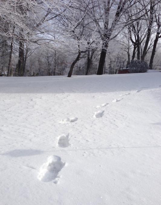
3" snow on the ground.
Deja Vu?
Uh
oh. There's snow on the ground. Its cold out. Does this mean another
pioneer winter? Our parents tracked cold fronts, now we have the polar
vortex to babble about.
"Paul, this is the EXACT same pattern we
had last winter and for the most part, spring and summer of 2014 also.
Give me reasons, based in facts, why this winter WILL NOT be a repeat of
last winter" wrote Bill Holton in Woodbury.
The reality: rapid
warming of the Arctic seems to be impacting jet stream winds, making
them more unstable, more prone to high-amplitude blocking patterns,
where weather stalls for weeks at a time. Lighter steering winds aloft
allow cold air brewing over Canada to push more south than east, with
potentially more frequent invasions of the Lower 48.
What's
different from last winter? El Nino is still forecast to kick in, which
should reduce the odds of a bitter blocking pattern identical to last
winter. Weather may rhyme, but it rarely repeats.
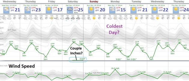
Today will be
typical, for mid January. Slap on an extra layer or two - wind chills
flirt with zero at the bus stop this morning. A couple inches of light
snow may fall Saturday; a reinforcing shot of numbing air keeps highs in
the upper teens Sunday & Monday. I still see a thaw just in time
for Thanksgiving.
That's it for 70s though. If anyone asks 40F is the new definition of "warm front".
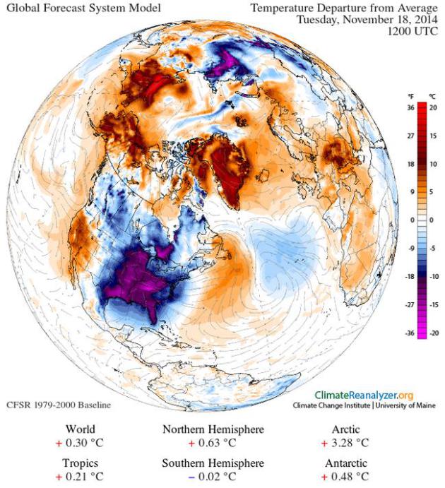
Temperature anomalies next Tuesday morning, November 18, obtained using Climate Reanalyzer (
http://cci-reanalyzer.org), Climate Change Institute, University of Maine, USA.
Only 20 Degrees Colder Than Average.
Payback for a mesmerizingly magical October? No idea, but I'm still not
convinced it's an omen of what's to come. Not to minimize the chill,
which will truly feel like mid January looking out nearly 2 weeks. A few
inches of snow Saturday gives rise to a reinforcing cold frontal
passage Sunday; wind chills Monday may dip well below zero.
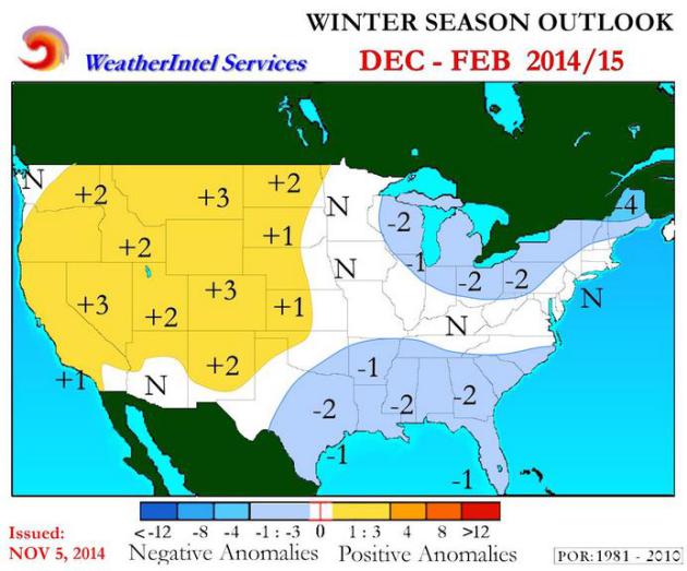
Long Range Winter Outlook.
I agree with most of Steve Gregory's logic and thought-process. Odds
favor that this won't be a carbon copy of last winter, for a variety of
reasons. Here's an excerpt of his winter outlook at
Weather Underground: "...
Based
on the extended range GFS and EURO global ensembles, dynamical trends,
along with forecasts and tools available from NOAA, Australia’s Bureau
of Meteorology (BOM) and various University and Research group models
(all of which call for at least some further strengthening of El Niño) –
point towards a generally cold start to winter. However, unlike last
year when we had long duration cold air events that included several
cross-polar flow patterns – there should be a more progressive and
stronger maritime influence as a more westerly flow of air moves into
western North America due to an El-Niño like wind pattern. Using the
CFSv2 and NMME Model Ensembles (that are made up many well known global
and specialized climate models) an El Niño-like driven winter pattern
should develop by late DEC or by mid JAN...."
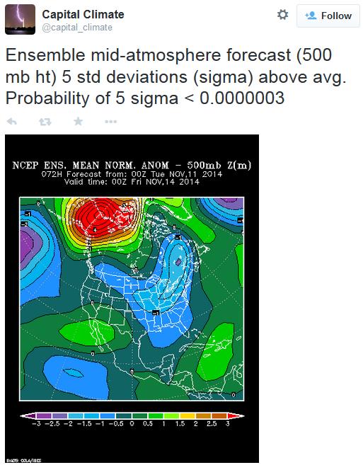
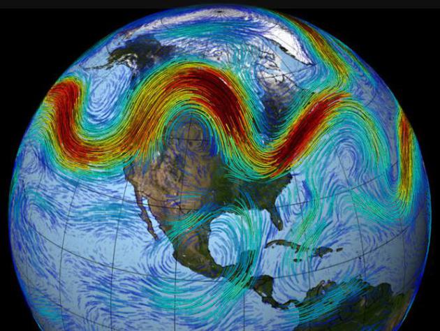
Current Blocking Pattern: A 5 Sigma Event?
Capital Climate shares a NOAA NCEP graphic showing extreme ridging over
Alaska and far northern Canada, resulting in unseasonable warmth, in
contrast to the first wave of cold air pushing across the USA. Some of
this may be sharp, sudden amplification of the pattern from the remains
of Typhoon Nuri energizing the jet stream. It brings back memories of
last winter, but the more important question is: will the block linger
for months at a time, or will we see a more variable pattern,
alternating between bitter cold and milder, Pacific air? I'm still
leaning toward the latter solution, a winter somewhat closer to
"average" as a mild to moderate El Nina kicks in.
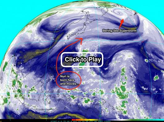
Evolution of a Super Storm - Culprit In Polar Vortex Redux.
New research suggests that ex-typhoons can energize jet stream winds as
they recurve toward the northeast, helping to create the kind of
high-amplitude (wavy) pattern that can pull unusually cold air south
(east of the Rockies) or warm air north (California to Alaska). Here's
an excerpt from
Discover Magazine: "...
Nuri’s
spawn, the Bering Sea superstorm, has kicked the jet stream over North
America into an exaggerated wavy pattern. This allowed unusual warmth to
build along the West Coast over the weekend, and a chunk of the polar
vortex to plunge south over the northern plains and farther south. Right
now, in fact..."
Image credit: "Click for an animation of infrared satellite images showing the birth and evolution of Super Typhoon Nuri." (Source: CIMSS Satellite Blog)
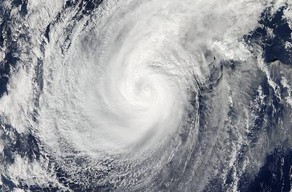
Watch Super Typhoon Nuri Become Bering Sea "Bomb".
Salon has a good recap of Nuri's track and intensity; an historic storm for Alaska: "
Super Typhoon Nuri, a storm that is making its way across the Bering Sea, has quickly solidified its reputation as the most powerful
storm to ever hit the region. The bigger the storm is, the lower the
air pressure. Surface weather stations captured data indicating that
Nuri reached 924 millibars (mb), breaking the previous record of 925 mb
set in 1977 in Dutch Harbor, Alaska. Nuri’s air pressure dropped so
rapidly that it became a “bomb...”
Image credit above: "This
Nov. 5, 2014 photo provided by NASA shows a picture captured by NASA's
Aqua satellite of Typhoon Nuri. Weather forecasters say an explosive
storm, a remnant of Typhoon Nuri, surpassing the intensity of 2012's
Superstorm Sandy is heading toward the northern Pacific Ocean and
expected to pass Alaska's Aleutian Islands over the weekend." (Credit: AP/NASA).
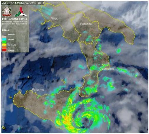
A Tropical Storm in the Mediterranean? Nothing official, but check out the imagery from Protezionecivile Italy, via
Weather Underground. That doesn't look like a generic cluster of thunderstorms to me.
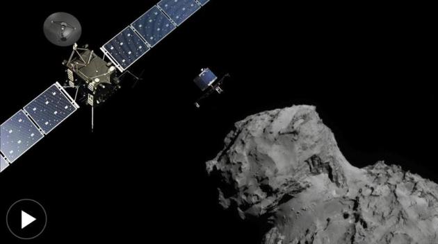
Rosetta Mission: Scientists Gear Up For Dramatic Bid To Land Probe on Comet. Talk about hitting a moving object with no room for error;
The Wall Street Journal has the fascinating story, here's an excerpt: "
In
what promises to be a nail-biting event worthy of a Hollywood script,
rocket scientists Wednesday will attempt the challenging task of trying
to land a probe on the surface of a comet. After a decadelong trek
through the solar system, the European Space Agency’s spacecraft Rosetta
made a historic rendezvous with a comet known as
67P/Churyumov-Gerasimenko in August. The craft is now in orbit just 6
miles above the comet’s surface. If all goes well, a small probe called
Philae will descend from the mother ship and become the first craft to
ever survive a landing on a comet..."
The Knowledge, London's Legendary Taxi-Driver Test, Puts Up a Fight In The Age of GPS. And you thought there was a lot of memorization with your job? Here's a clip from a fascinating (and intimidating) story at
The New York Times: "...
Actually,
“challenge” isn’t quite the word for the trial a London cabby endures
to gain his qualification. It has been called the hardest test, of any
kind, in the world. Its rigors have been likened to those required to
earn a degree in law or medicine. It is without question a unique
intellectual, psychological and physical ordeal, demanding unnumbered
thousands of hours of immersive study, as would-be cabbies undertake the
task of committing to memory the entirety of London, and demonstrating
that mastery through a progressively more difficult sequence of oral
examinations — a process which, on average, takes four years to
complete, and for some, much longer than that..."
TODAY: Clouds and flurries. West 15+ Wind chill: 10F. High: 22
WEDNESDAY NIGHT: Scrappy clouds, few flurries. Low: 12
THURSDAY: Partly sunny. Still brisk. High: 24
FRIDAY: Plenty of sun. Welcome lack of bugs. Wake-up: 8. High: 27
SATURDAY: Light snow, few inches possible. Wake-up: 12. High: 28
SUNDAY: Windy, turning colder again. Wake-up: 16. High: 23
MONDAY: Clouds and flurries. Wind chill: 5. Wake-up: 9. High: 18
TUESDAY: Mostly cloudy, enjoying January. Wake-up: 5. High: 24
Climate Stories...
Breaking News: U.S. and China Reach Deal on Climate Change in Secret Talks. Here's a summary from
The New York Times.
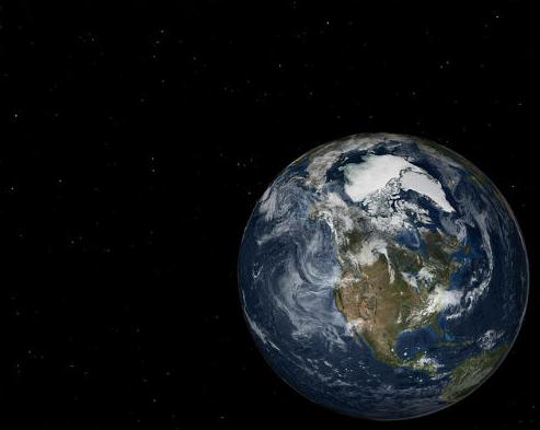
Is The Polar Vortex Evidence of Global Warming. Actually Yes, It Is. Catholic Online
delves into unprecedented warming of the Arctic and how this may be
impacting the speed and configuration of the polar vortex, causing more
southward intrusions of bitter air across North America during the
winter months; here's an excerpt: "...
Temperature data from the
Arctic shows the sea is warming much faster there than in other regions.
This warms the Arctic, meaning the temperature difference between the
Arctic and the temperate weather below the jet stream is reduced. The
temperature difference between the two air masses matters because that's
what keeps the jet stream blowing strongly in place. When that
difference becomes less, the jet stream meanders and forms kinks. When
one of those kinks drops low towards the south, a polar vortex is
formed, bringing frigid arctic air south. As the Arctic oceans lose
their sea ice, more polar vortexes can be expected..."
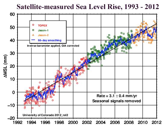
Rising Sea Level is Inevitable, but "Nobody Is Truly Ready". Here's a clip from a story at Climate Central and
Raw Story: "...
The
report warns that coastal property and infrastructure could be a foot
lower in just a few decades than is the case today, portending an
unprecedented crisis for which the nation appears to be frightfully
ill-prepared. U.S. coastal cities, established in centuries past when
seas were 8 inches lower than they are today, are now flooding regularlyduring high tides. Despite decades of research and warnings, little has been done to defend against the slow-motion marine invasion of landlubbers’ territory...."
Your Brain on Climate Change: Why The Threat Produces Apathy, Not Action.
Why are some of us hard-wired to ignore or minimize the risk posed by a
warmer, more volatile climate? Here's an excerpt of a story at
The Guardian: "...
Many
environmentalists say climate change is happening too fast. No, it’s
happening too slowly. It’s not happening nearly quickly enough to get
our attention.” Humans are saddled with other shortcomings, too. “Loss
aversion” means we’re more afraid of losing what we want in the
short-term than surmounting obstacles in the distance. Our built-in
“optimism bias” irrationally projects sunny days ahead in spite of
evidence to the contrary. To compound all that, we tend to seek out
information not for the sake of gaining knowledge for its own sake, but
to support our already-established viewpoints..."
Why Climate Activists Fail To Attract Conservative Support - And What They Can Do About It.
The Olympian has a story that caught my eye - here's an excerpt: "...
Hard
skeptics are fundamentally motivated by their deeply held values of
individual liberty, innovation, the power of markets and
constitutionally limited government, Leiserowitz writes. And they deny
climate change because they believe the solutions put those values in
jeopardy. In short, he says, they are skeptical because they detest the
solutions, which expand the scope and power of a government they deeply
distrust. A noteworthy cohort of this group passionately rallies against
National Security Agency spying, foreign intervention and corporate
welfare, which they call crony capitalism, as issues that expand the
power of a corruptible state. In this mindset, any issue that calls for
the expansion of state powers, even if seemingly benign, is suspect..."
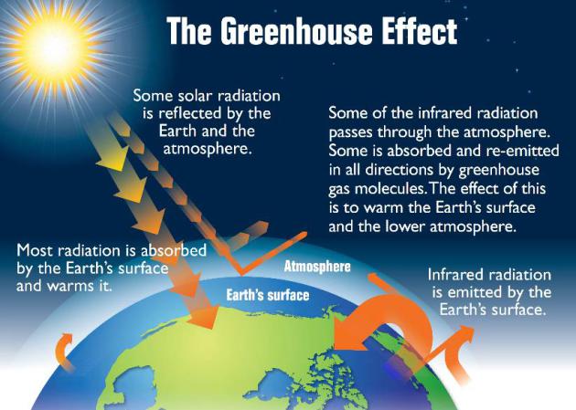
Global Warming Is Not Just A Blanket. In The long Run, It's More Like Tanning Oil. The University of Washington has an interesting story - here's a clip: "...
Regardless
of what happens to clouds, these researchers say, the planet is likely
to have less ice and the air will become more humid under climate
change, both of which will act to absorb more shortwave radiation from
the sun. Those effects will be like putting tanning oil on the planet,
letting it absorb more of the sun’s incoming rays. Melting ice creates
darker surfaces that can absorb more heat, and the more melting the more
heat it can absorb. Likewise, warmer air holds more water vapor,
causing it to absorb solar radiation that might otherwise bounce back
off clouds, ice or snow..."
Graphic credit above: "
The
sun emits short, high-energy wavelengths: visible light and ultraviolet
radiation. Earth absorbs this energy and emits it as long-wave, or
infrared, radiation.
" EPA.
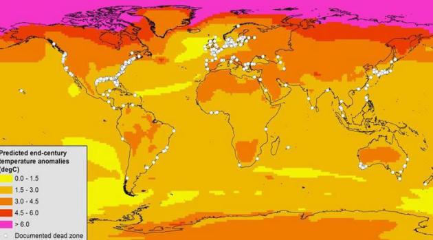
Ocean Dead Zones Are Getting Worse Globally Due to Climate Change. Here's an excerpt from a story at Smithsonian: "
Nearly all ocean dead zones
will increase by the end of the century because of climate change,
according to a new Smithsonian-led study. But the work also recommends
how to limit risks to coastal communities of fish, crabs and other
species no matter how much the water warms. Dead zones are regions where
the water has unusually low dissolved oxygen content, and aquatic
animals that wander in quickly die. These regions can form naturally,
but human activities can spark their formation or make them worse..."
Map credit above: "This
map of known dead zones (white dots) shows how much annual air
temperatures are expected to change by 2080-2099 compared with 1980-1999." (Keryn Gedan and Andrew Altieri/Smithsonian).

No comments:
Post a Comment