41 F. high in the Twin Cities Sunday.
25 F. average high on January 31.
28 F. high on January 31, 2015.
+ 1.5 F. January temperatures are running 1.5 degrees warmer than average at MSP, as of January 30.
1" snow left on the ground at KMSP.
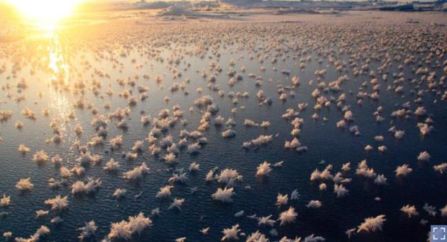
February 1, 1931: A 'heat wave' develops across southern Minnesota. St. Peter hits 60.
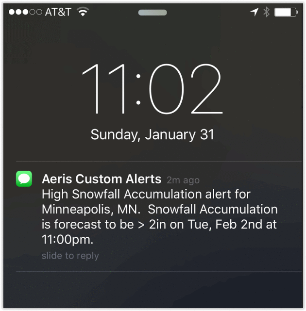
Brushed by a Blizzard - The Politics of SnowTV
talking heads babbling about politics almost make the meteorologists
look good. No hedging, place your bets! Iowa is under a Blizzard Watch
but heaviest snows come
tonight, well after the caucus votes.
There's some
anecdotal evidence that rain and snow favors Republican candidates in general elections. Then again you can prove anything with statistics.
It's
almost appropriate that Iowa will bear the brunt of the blizzard, with a
foot of wind-whipped snow for Des Moines. The term "blizzard" was
originally used to describe a volley of cannon and musket fire. In 1870 a
creative editor at an Iowa newspaper borrowed the word to describe a
severe winter storm, an extreme "volley of snow" and a new, enduring
definition was born.
The heaviest snow bands set up over southeast
Minnesota but a period of (light) accumulating snow is still possible
in the metro
Tuesday, especially southern and eastern suburbs. The PM hours
tomorrow may still be a slushy mess.
Seasonably chilly air follows the storm but latest models aren't as cold as two weeks ago, in fact we may thaw out again by
Sunday.
40s this past weekend? Felt good.
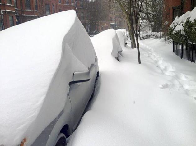
A Very Close Call.
The final verdict (still) isn't in on this next storm, but most model
guidance pushes the heaviest bands of accumulation south of the Twin
Cities. This could be a major (epic?) snowstorm, with blizzard
conditions from Denver to Omaha and Des Moines; plowable amounts
brushing southern Minnesota and much of central and northern Wisconsin.
If your travels take you south/east of MSP tomorrow you'll want to stay
up on the latest forecast. Personally I'd leave today. NAM guidance:
NOAA.
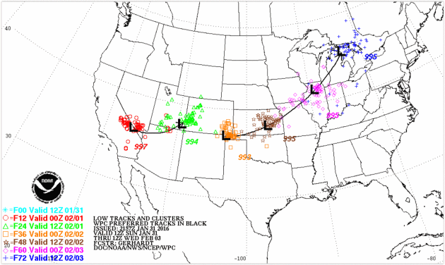
Projected Storm Track.
The latest NOAA model ensembled show a track 150-200 miles too far
south and east for heavy snow here in the metro. We could still wind up
with a couple of inches, even plowable amounts from Northfield to
Hastings and Stillwater, but I don't think this will wind up being
Snowzilla for MSP.
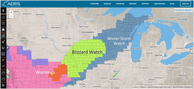
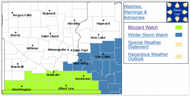
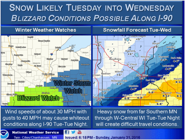
Blizzard Watch Southern Minnesota.
This will be a close call, but the best chance of treacherous/dangerous
weather should come over far southern Minnesota, close to I-90 as the
same storm that buffeted California (and Denver) pushes a shield of
heavy, wind-whipped snow across Iowa into Wisconsin, brushing far
southern counties. Details via NOAA:
WINTER STORM TO IMPACT SOUTHERN MINNESOTA AND WEST CENTRAL WISCONSIN TUESDAY AND TUESDAY NIGHT...

A STRONG WINTER STORM IS FORECAST TO BRING ACCUMULATING SNOW AND STRONG WINDS TO A PORTION OF THE UPPER MIDWEST TUESDAY AND TUESDAY NIGHT. CONFIDENCE IS INCREASING ON THE POTENTIAL FOR SIGNIFICANT SNOW ACCUMULATIONS AND TRAVEL IMPACTS IN FAR SOUTHERN MINNESOTA THROUGH WEST CENTRAL WISCONSIN. STRONG WINDS ACROSS SOUTHERN MINNESOTA MAY RESULT IN WHITEOUT CONDITIONS TUESDAY AFTERNOON AND TUESDAY NIGHT.

AS A RESULT...A BLIZZARD WATCH IS IN EFFECT FOR MUCH OF SOUTHERN MINNESOTA TUESDAY AND TUESDAY NIGHT ALONG AND SOUTH OF A LINE FROM ST. JAMES THROUGH MANKATO TO OWATONNA. A WINTER STORM WATCH IS IN EFFECT FOR SOUTHEAST AREAS OF MINNESOTA...INCLUDING FARIBAULT AND RED WING AS WELL AS FOR PORTIONS OF WEST CENTRAL WISCONSIN...INCLUDING RIVER FALLS...MENOMONIE...DURAND...CHIPPEWA FALLS AND EAU CLAIRE.
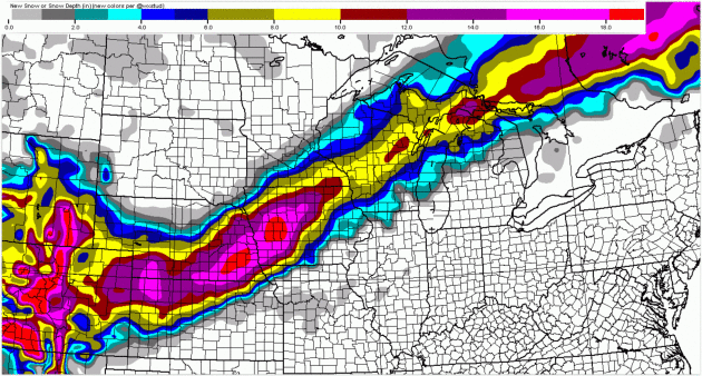
Blame (or thank) El Nino.
As I've said (ad nauseum) El Nino tends to hijack storm track much of
the winter, nudging the storm track consistently south of Minnesota,
whisking the biggest, wettest storms to our south. An energized southern
storm track often spells major storms from California to the central
and southern Plains and East Coast. We'll get a taste, but probably only
a taste. NAM snowfall forecast: AerisWeather.
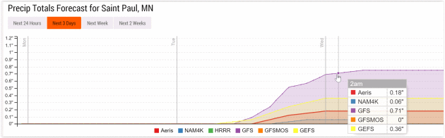
Significant Model Divergence.
With snow 24 hours away I'd like to see the models in tighter
alignment. ECMWF is more in line with GFS, still suggesting a plowable
snow for MSP, more than 4-5". But 12K and 4K NAM are trending much
lighter precipitation amounts, shoving the storm track too far south and
east for a big pile of white in the metro area. My confidence level
with this (alleged) storm is still pretty low for an event one day away.
Guidance: Aeris Enterprise.
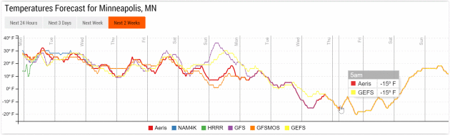
Not As Cold.
European guidance isn't as cold as NOAA models for the cool-down later
this week, in fact it hints at another potential thaw from Friday into
Sunday as the main core of bitter air rotates southward across Canada,
possibly setting the stage for much colder weather next week. The best
chance of snow over the next week: Tuesday, again late Sunday into early
Monday. Guidance: WeatherSpark.
Numb and Number Next Week.
We may be spared a significant chill this week, but GFS guidance still
suggests a few nights below zero by the middle of next week. Not as cold
as a couple weeks ago, but parka weather may be 8-10 days away. I
suspect the groundhog will not see his shadow tomorrow. 6 more weeks of
winter seems like a good bet at this latitude.
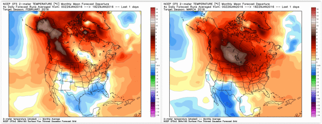
Warm Phase Returns Second Half of February into March?
NOAA's CFSv2 (Climate Forecast System) model still shows a mild bias
for February, which implies a fairly radical warming trend the latter
half of next month. A lingering El Nino signal is forecast to result in
significantly milder than average temperatures anomalies for central
Canada and the northern tier states of the USA in March. We'll see.
Study: No Proof of Seasonal Depression. Really? A new study highlighted at
KARE11.com made me do a triple-take; here's an excerpt: "...
Researchers
looked at a survey of more than 34,000 adults in the United States.
According to their results, there was no evidence that season, latitude
and sunlight exposure had a significant effect on a person’s symptoms of
depression. “We analyzed the data from many angles and found that the
prevalence of depression is very stable across different latitudes,
seasons of the year, and sunlight exposures,” said Steven LoBello in a
released statement. LoBello is a professor of psychology at Auburn
University at Montgomery and senior author on the study. “The findings
cast doubt on major depression with seasonal variation as a legitimate
psychiatric disorder,” the researchers wrote..."
Morphing of The Word "Blizzard". Up until the late 1800s the term had nothing to do with snow, as described at
Voice of America: "...
The dictionary Etymology Online says blizzard came to mean a severe snow storm during the late 1800s. Before then, the word blizzard had nothing to do with snow. It had several other meanings. One was a sharp blow, like hitting a ball with a stick. Another meaning was a gun shot. And blizzard was also defined as a most extreme statement or event. These days, we do not use blizzard to mean any of those things. Blizzard is only used to mean an extreme snow storm. The first such use was in 1870. An especially violent and heavy snowstorm struck the state of Iowa. This storm was the worst winter storm in a long time. A newspaper editor in a small Iowa town called the terrible storm a blizzard..."
An Unprecedented Threat to Privacy.
And here you thought Google Street View was invasive? A private company
amassing a database of over 2 billion photos of license plates? Here's
the intro to a story at The Atlantic: "Throughout
the United States - outside private houses, apartment complexes,
shopping centers, and businesses with large employee parking lots - a
private corporation, Vigilant Solutions,
is taking photos of cars and trucks with its vast network of
unobtrusive cameras. It retains location data on each of those pictures,
and sells it. It's happening right now in nearly every major American
city. The company has taken roughly 2.2 billion license-plate photos to
date. Each month, it captures and permanently stores about 80 million
additional geotagged images. They may well have photographed your
license plate..."
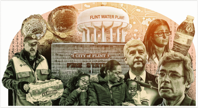
What Went Wrong in Flint? FiveThirtyEight
has an exhaustive, well-researched article about the chain reaction of
errors (and horrors) now playing out in Flint, Michigan, and other
Flints around the USA; here's an excerpt: "..
.Lead is an extensively studied neurotoxin, and decades of research show that there is no safe level of exposure.
Although most elevated blood lead levels today are not high enough to
cause immediate problems, there are many long-term effects of lead
exposure, even for small doses. While it’s impossible to say what effect
a low exposure will have on an individual child, research is fairly
clear on what it does to a population. It causes miscarriages and low
birth weight for babies, and it shifts the entire IQ of a population
down a few points. It’s also believed to cause decreases in impulse
control and increases the incidence of attention deficit hyperactivity disorder, learning disabilities and potentially violent behavior..."
Graphic credit above:
Ritchie King and
Ella Koeze
28 Secrets of Incredibly Productive People. More clickbait? Actually there's some good information in a story at
TIME; here's a clip that caught my eye: "...
No is a powerful, productive word (James also wrote a book about it).
We think we’re obligated to say yes to everything, and then we wonder
why we never have enough time. Learning to say no–more specifically,
“No, thank you”–will energize you and excite you. Use it–as much as you
can. Another from James: Entrepreneurs (and writers) are nuts. To save
yourself many wasted hours of time and insanity, find a spouse who is
better adjusted and balanced than you..."
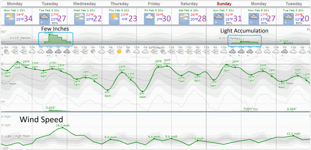
 TODAY
TODAY: Some sun, no problems. Winds: W 3-8. High: 34
MONDAY NIGHT: Partly cloudy, still dry. Low: 23
TUESDAY:
Snow develops by afternoon, becoming windy. An inch or two of
accumulation possible, more southeast metro - difficult travel southern
and southeastern MN and southwest WI. Winds: NE 15-25. High: 27
WEDNESDAY: Flurries taper, partial clearing as winds diminish. Winds: NW 10-15. Wake-up: 13. High: 19
THURSDAY: Flurries, still cooler than average. Wake-up: 10. High: 23
FRIDAY: Another clipper, snowy coating? Wake-up: 13. High: 25
SATURDAY: Partly sunny, storm-free. Winds: S 5-10. Wake-up: 9. High: 22
SUNDAY: Sunny peeks, risk of a thaw. Winds: SE 7-12. Wake-up: 19. High: 33
Climate Stories...
The Climate-Change Refugee Crisis Is Only Just Beginning. Climate
change and increasing volatility in weather (and water resources) as a
"threat multiplier" - a perpetual planetary migraine that flavors
troublespots, especially in unstable regions, like Africa and The Middle
East. Here's an excerpt from
Quartz: "...
These
days, climate change is in vogue. Everything from the war in Syria to
unrest in West Africa has been laid at the feet of the weather gods.
Some of the claims have been dismissed as spurious. But there’s plenty of evidence that migration in sub-Saharan Africa is indeed partly due to extreme weather. 70% of the continent’s migrants
have left their homes because of poverty or a lack of work, according
to research provided by the UN. Environment Program (UNEP). The authorities estimate the number of migrants by counting the bodies of those who’ve succumbed to the heat. An estimated 64% of Africans—and close to 90% of Ethiopians—earn their living from agriculture..."
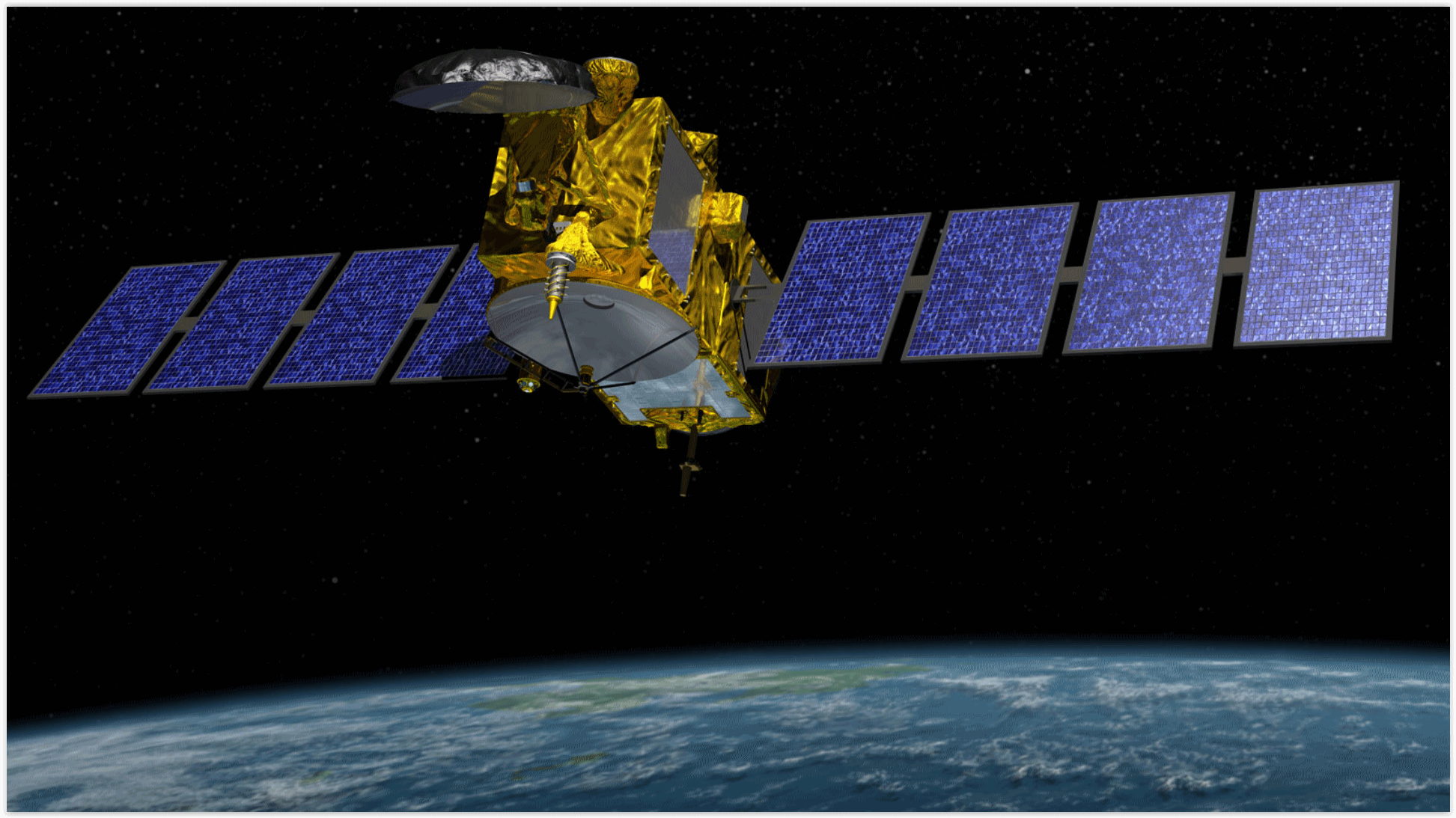
New Satellite Collects Sea Level Data to Monitor Climate Change.
Voice of America (VOA) has the article; here's a link and intro: "
Scientists
from the U.S. and Europe have a new eye in the sky monitoring the
world's oceans.The Jason-3 satellite, launched on January 17, is the
latest satellite to monitor rising sea levels. Scientists say data
collected by satellites over the last two decades shows sea levels
rising at an accelerating rate, which they say is an indicator of
climate change. Josh Willis, Lead Project Scientist for the Jason-3
mission at NASA’s Jet Propulsion Laboratory said rising sea levels were
one of the factors that contributed to the destruction wrought by
Hurricane Katrina in 2005. Hundreds of people died and the storm surge
devastated gulf coast communities as Katrina became one of the deadliest
storms in recent U.S. history..." (Image from NOAA NESDIS, which has more information on Jason-3
here).
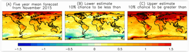
5-Year Global Trends. Here's an excerpt from a (very) extended outlook from the
UK Met Office, based on global atmospheric and oceanic trends:
- Averaged
over the five-year period 2016-2020, forecast patterns suggest enhanced
warming over land, and at high northern latitudes. There is some
indication of continued cool conditions in the Southern Ocean, and of
relatively cool conditions in the North Atlantic sub-polar gyre. The
latter is potentially important for climate impacts over Europe, America and Africa.
- During
the five-year period 2016-2020, global average temperature is expected
to remain high and is likely to be between 0.28°C and 0.77°C above the
long-term (1981-2010) average. This compares with an anomaly of +0.44 ±
0.1 °C observed in 2015, currently the warmest year
on record. These high global temperatures are consistent with continued
high levels of greenhouse gases and big changes that are currently
underway in the climate system and were highlighted in a recent Met
Office research news article...
Image credits above: "
Forecast
(A) of surface temperature differences (°C) relative to 1981-2010 for
the 5-year period November 2015 to October 2020. Forecasts consist of 10
ensemble members starting from November 2015. The probable range is
diagnosed from the ensemble spread, and shown as the lower (B) and upper
(C) limits for each 5° grid box, such that there is a 10% chance of the
observations being cooler than (B), and a 10% chance of the
observations being warmer than (C). Note that the actual anomaly
patterns in (B) and (C) are unlikely to occur since extreme fluctuations
would not be expected at all locations simultaneously."
Temperature Study of Last Two Millenia "Confirms Global Warming a Reality." Here's the intro to a story at
BT.com: "
Recent
summers have been the warmest in Europe in the past two millennia,
scientists have said. Researchers from 13 countries including the UK
have used information from tree rings and historical records to
reconstruct summer temperatures stretching back 2,100 years. The data
suggests greater natural variation in summer temperatures, seen in warm
conditions in Roman times, cooler summers in the 4th to 7th centuries, a
warm medieval period and a cold Little Ice Age from the 14th to 19th
century, than previously thought...
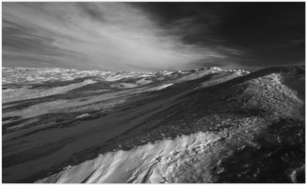
Cloud Blanket is Warming Up a Melting Ice Cap. Here's the intro to an update from
Truthdig.com: "
Researchers have identified another piece in the climate machinery that is accelerating the melting of the Greenland ice cap.
The icy hills are responding to the influence of a higher command
system: the clouds. An international research team led by scientists
from the Catholic University of Leuven in Belgium report in Nature Communications journal
that cloud cover above the northern hemisphere’s largest single volume
of permanent ice is raising temperatures by between 2 degrees and 3
degrees C and accounting for 20-30% of the melting. The conclusion,
based on imaging from satellites and on computer simulations, is one
more part of the global examination of the intricate climate systems on
which human harvests, health and happiness ultimately depend..."
Photo credit above: "
Cloud cover shrouds the ice cap near Kangerlussuaq in western Greenland." (Nikolaj F. Rasmussen via Flickr).


No comments:
Post a Comment