Wintry Wonderland

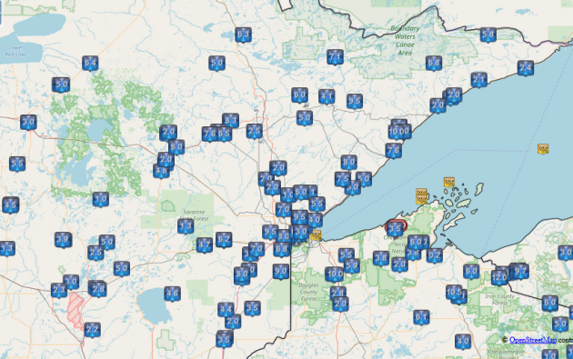
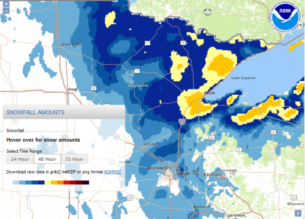
Snowfall Analysis
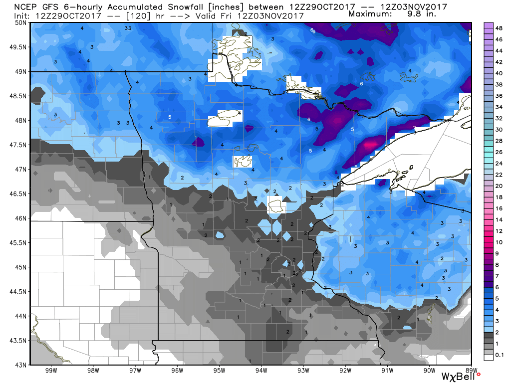
Here's the snowfall analysis since late last week, which shows the heaviest snow from our first winter storm of the season. For some, it was barely a storm, but others had nearly 10" or more near Lake Superior.

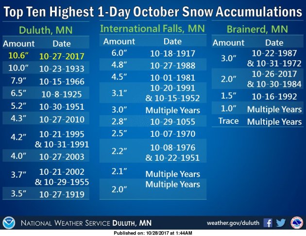
Snowiest October Day in Duluth, MN
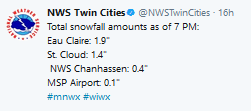
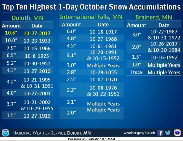
On Friday, October 27th, Duluth had 10.6" of snow, which was the snowiest October day on Record! Meanwhile, the official report from the MSP Airport was only 0.1" - However - it was the first time that the Twin Cities has seen measurable snow in October in 9 years!
____________________________________________________________
Minnesota Fall Color Update
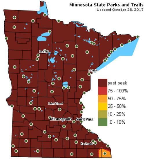
And just like that, our fall color season has come to an end... there isn't much left out there. Maybe a few stubborn trees still holding onto their leaves, but according to MN's DNR, most of the state is past peak in the fall color department.
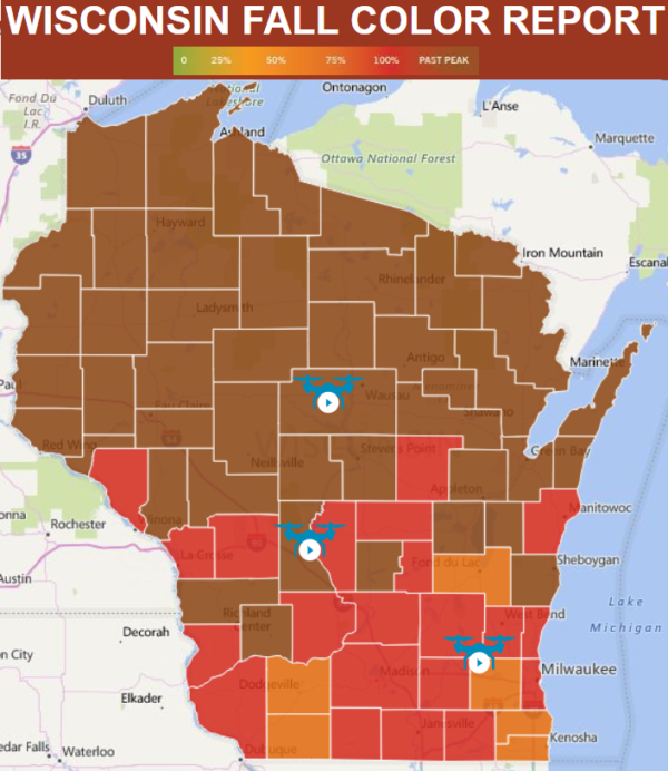
Wisconsin Fall Color UpdateIf you're still in search of fall color, you still have a chance across parts of southern Wisconsin, but it's going fast! HURRY!
See more from Travel Wisconsin HERE:
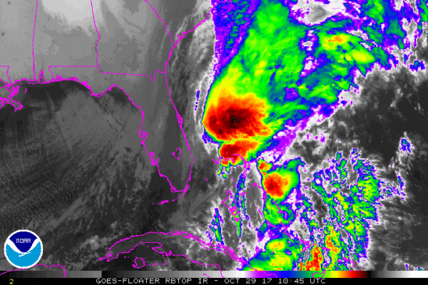
Here's a look at PHILLIPPE from Sunday afternoon, which according to NOAA's NHC was 16th named storm of the 2017 Atlantic Hurricane Season.
Tracking PHILLIPPE
The official track of PHILLIPPE shows the center of the storm will stay out at sea, but moisture from this system is being pulled into the Eastern US

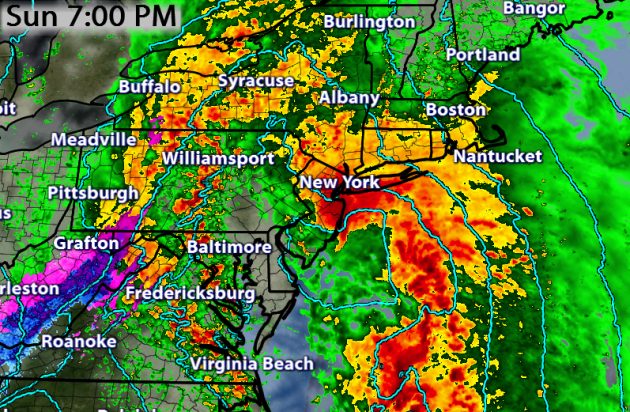
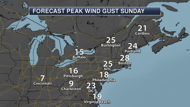
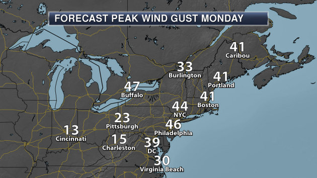
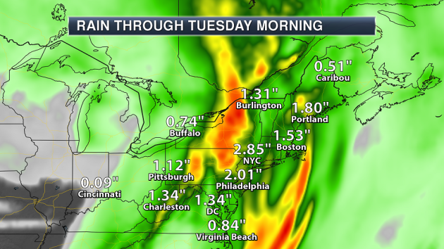
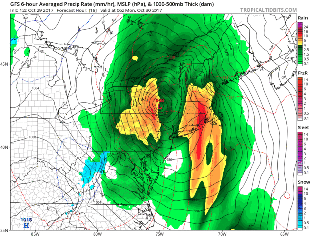
Wet & Windy in the Northeast
The storm system bringing heavy rain and wind to the Northeast will continue on Monday.


Meteorologist DJ Kayser
_________________________________________________________________
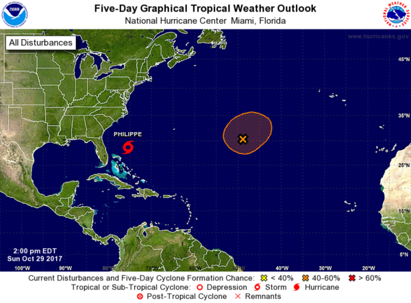
Atlantic Outlook Next 5 Days
Here's the Atlantic outlook over the next 5 days, which shows PHILIPPE just east of Florida, but there is also another wave of energy in the Central Atlantic that has a MODERATE chance of tropical formation.
__________________________________________________________
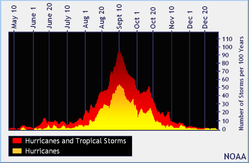
September 10th - Official Peak of the Atlantic Hurricane Season
Here's the average Atlantic hurricane season, which shows that peak activity generally occurs on September 10th and stays somewhat active through the month of October, but really diminishes through the month of November. Again, the Atlantic Hurricane Season doesn't officially end until November 30th.
___________________________________________________________
"Full recovery from California wildfires may take years"
"Officials say it will take at least months and likely years to fully recover from devastating wildfires that ripped through Northern California earlier this month, killing 42 people and destroying at least 8,900 structures. Sheriff Rob Giordano said Saturday "We don't control these things, and it makes you realize how small you are in the world when something like this happens." Giordano spoke before hundreds of people gathered at a college in Santa Rosa, one of the hardest-hit cities, for a memorial service to honor the lives lost. The deadliest series of wildfires in California history started Oct. 8, eventually forcing 100,000 people to evacuate. U.S. House Minority Leader Nancy Pelosi and five members of Congress attended the memorial, toured fire-ravaged areas and heard federal, state and local officials describe what Congress can do to aid the recovery efforts."
See more from STLToday.com HERE:

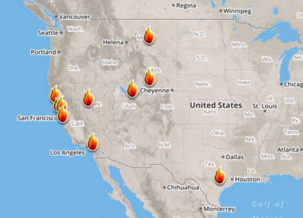
Ongoing Large Wildfires
Here's a look at the current wildfire map across the country. While several fires are still ongoing, fire weather conditions have been improving a bit for folks in the Western US.
Here's a list of all the current large wildfires from Inciweb:
Here's a list of all the current large wildfires from Inciweb:
_________________________________________________________
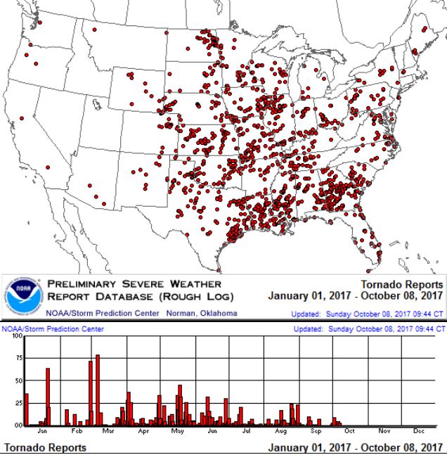
PRELIMINARY 2017 Tornado Map
It certainly has been a fairly active first half of 2017 with 1,463 preliminary tornado reports through October 28th. Note that this is the most tornadoes through that date since 2011, when there were 1,897 reports. The map below shows the distribution of the tornadoes so far this year.
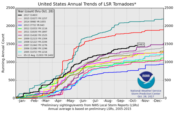
 PRELIMINARY 2017 Tornado Count
According to NOAA's SPC, the PRELIMINARY 2017 tornado count is 1,463 (through October 28th). Note that is the most active year for tornadoes since 2011, when there were 1,897 tornadoes. Keep in mind there was a major tornado outbreak in the Gulf Coast region from April 25-28, 2011 that spawned nearly 500 tornadoes, some of which were deadly. That outbreak is known as the Super Outbreak of 2011 and has gone down in history as one of the biggest, costliest and one of the deadliest tornado outbreaks in history.
_____________________________________________________________________
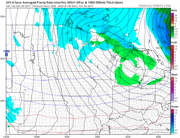
2.) Heavy snow across portions of the Great Lakes and the Upper Mississippi Valley, Mon-Tue, Oct 30-Oct 31.
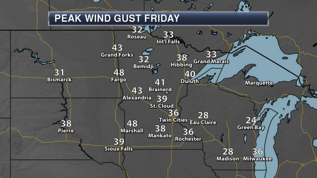
3.) High winds across portions of the Central Plains, the Northern Plains, the Middle Mississippi Valley, and the Upper Mississippi Valley, Mon, Oct 30.
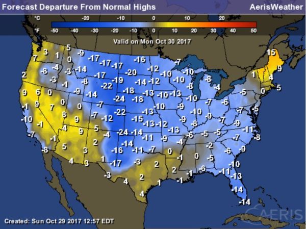
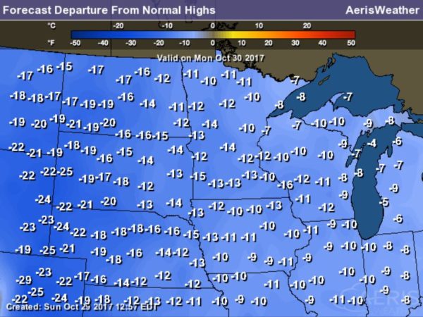
4.) Much below normal temperatures across portions of the Southeast, Mon, Oct 30.
5.) Heavy snow across portions of the Northern Rockies and the Northern Great Basin, Wed-Thu, Nov 1-Nov 2.
6.) Heavy snow across portions of the Cascades, Thu-Fri, Nov 2-Nov 3.
7.) High winds across parts of the South Coast of Alaska and the Aleutians, Mon, Oct 30.
8.) High significant wave heights for coastal portions of the South Coast of Alaska and the Aleutians, Mon, Oct 30.
9.) High winds across portions of the Alaska Panhandle, Thu, Nov 2.
10.) Heavy snow across portions of the northern Sierras, Cascades, Idaho, Northern Great Basin, and Northern Rockies, Sat, Nov 4.
11.) High winds across portions of the Central Plains, the Central Rockies, the Central Great Basin, the Southern Rockies, the Southern Plains, and the Southwest, Sat-Sun, Nov 4-Nov 5.
12.) Heavy rain across portions of the Central Plains, the Lower Mississippi Valley, the Tennessee Valley, the Middle Mississippi Valley, the Southeast, the Southern Plains, and the Ohio Valley, Mon-Wed, Nov 6-Nov 8.
13.) Slight risk of much below normal temperatures for portions of the northwestern and North-Central CONUS, Sat-Thu, Nov 4-Nov 9.
14.) Moderate risk of much below normal temperatures for portions of Montana, Sun-Wed, Nov 5-Nov 8.
15.) Severe Drought across the Northern Plains, the Northern Rockies, and Hawaii.
16.) Flooding possible across portions of the Northeast and the Great Lakes.
17.) Flooding occurring or imminent across portions of the Southeast.

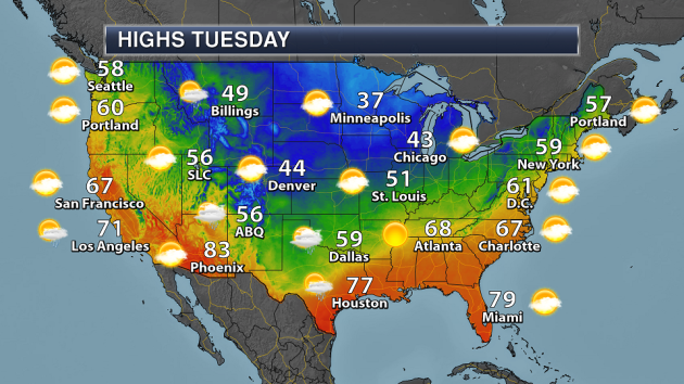
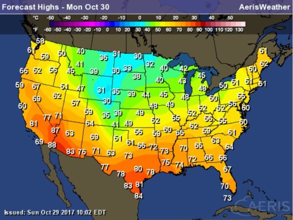
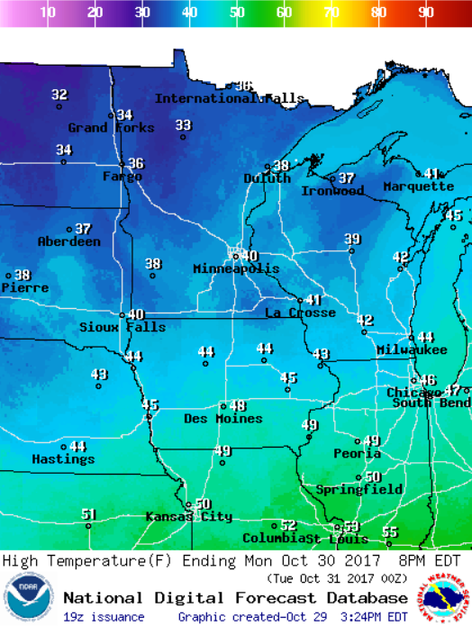
High Temps Monday
National Weather Outlook
.gif)
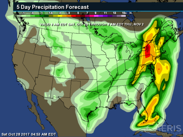
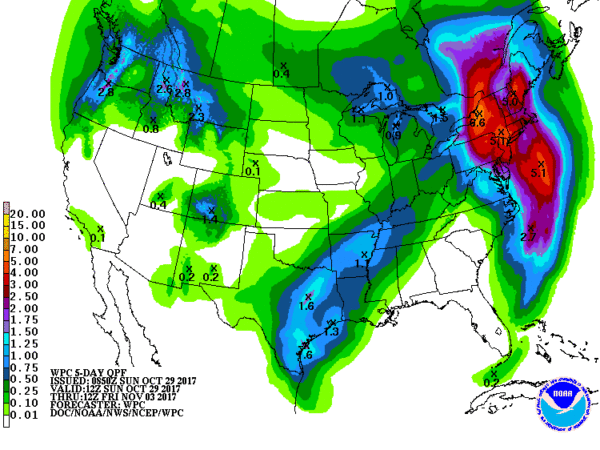
5 Day Precipitation Outlook
According to NOAA's WPC, areas of heavy rain will continue across parts of the Northeast as the strong storm continues there. Some spots could see as much as 3" to 6" before the system wraps up early in the week. Also note that some areas in the South-Central US could see up to 1" of rain or more, while folks in the Northwest could see as much as 2" of liquid or more.
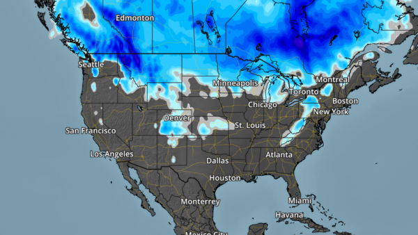
Snowfall Potential
Here's the snowfall potential over the next 5 days, which shows the heaviest snow falling across parts of Canada, but there will be some snow across parts of the Rockies and the northern tier of the nation, including more across the Midwest.
________________________________________________________________________
Lonely Snow Flurries Monday - Dry, chilly Halloween
By Paul Douglas
By Paul Douglas
The leaves are leaving and so are the snow birds. You think they know something we don't? A few spurts of reluctant warmth are on the way, but long range models look pretty cold. I wouldn't be at all surprised to see snow on the ground for Thanksgiving this year.
By the way, there is such a thing as a "reverse snow bird". A friend, Tom Skilling, is Chief Meteorologist at WGN-TV in Chicago. He bought a place up in Alaska, to increase his odds of seeing (real) snow and bitter cold! Only the brave and hardy trek north in midwinter.
With a sun angle as high in the sky today as it was on February 10, cold fronts are as inevitable as internet snark. A few decorative flurries float past your window today, but Halloween looks dry with temperatures stuck in the 30s.
The best chance of (rain) showers comes Wednesday, again Saturday as a warm front makes a pass at Minnesota. Delay leaf-raking & dock removal until Sunday, when the mercury may surge all the way into the 50s.
How far we've fallen. Give it a couple of months. By January FREEZING will be considered a "warm front".
________________________________________________________________________
Extended Forecast
MONDAY: Cold wind, few flakes. Winds: NW 15-30. High: 39.
MONDAY NIGHT: Breezy and cool. Slight chance of a light rain/snow mix. Winds: WNW 10-15. Low: 28.
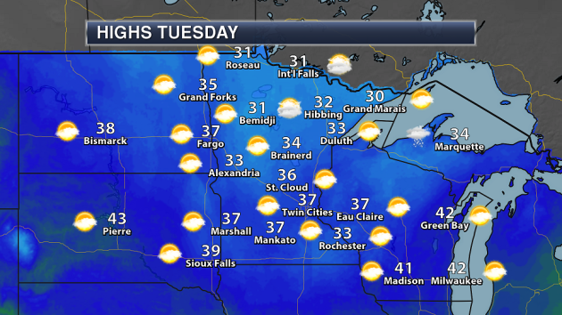
TUESDAY: Sunny peeks. A chilly Halloween. Winds: SW 7-12. High: 38.
WEDNESDAY: Light showers. Sloppy mix north. Winds: S 10-15. Wake-up: 30. High: 44.
THURSDAY: More clouds than sun. Probably dry. Winds: NW 8-13. Wake-up: 32. High: 45.
FRIDAY: Mix of clouds and sunshine. Winds: N 5-10. Wake-up: 31. High: 42.
SATURDAY: Showery rain. Cool and damp. Winds: SE 10-15. Wake-up: 33. High: 44.
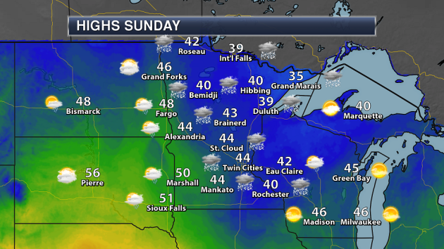
SUNDAY: A bit milder. Lingering showers. Winds: W 8-13. Wake-up: 41. High: 52.
_______________________________________________________
October 30th
1951: An early snow storm drops as much as 8 inches of snowfall in north central Minnesota. Mora had 8 inches, while Long Prairie received 6 inches. Glenwood, Little Falls, Morris, and New London all had 5 inches of new snow. Meanwhile, surrounding areas received a couple of inches.
1936: An intense dust storm causes damage in Central Minnesota. Heavy wind damage is reported in Stearns County.
________________________________________________________
Average High/Low for Minneapolis
October 30th
Average High: 51F (Record: 83F set in 1950)
Average Low: 35F (Record: 10F set in 1925)
Record Rainfall: 1.26" set in 1971
Record Snowfall: 0.8" set in 1951
_________________________________________________________
Sunrise/Sunset Times for Minneapolis
October 30th
Sunrise: 7:49am
Sunset: 6:04pm
Hours of Daylight: ~10 hours 52 mins
Daylight LOST since yesterday: ~2 minutes and 49 seconds
Daylight LOST since summer solstice (June 20th): 5 hours & 23 minutes
__________________________________________________________
Moon Phase for October 30th at Midnight
3.9 Days Until Full "Beaver" Moon
"Nov. 4, 1:23 a.m. EST – Full Beaver Moon. This was the time of year when the old Native American tribes set beaver traps, to ensure a supply of warm winter furs before the swamps froze. Another interpretation suggests that the name Beaver Full Moon comes from the fact that the beavers are now active in their preparation for winter. It's also called the Frosty Moon."

Weather Outlook For Monday
__________________________________________________________________________
Simulated Radar Ahead...
Here's the simulated radar across the Upper Midwest from Monday to midday Wednesday, which suggests areas of light precipitation continuing through the day Monday and starting up again on Wednesday.
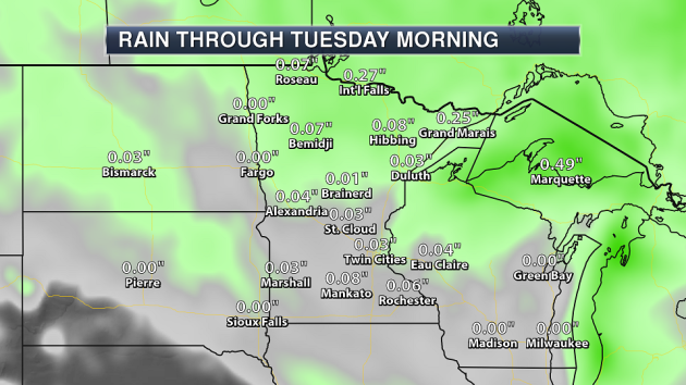
Precipitation Outlook Through Friday
Here's a look at how much precipitation could fall through the end of the week. Some spots across the Arrowhead could see up to 0.5" of liquid or more.
.png)
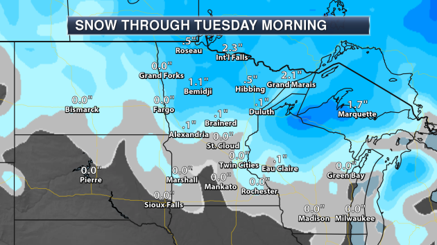
Snowfall Potential Through Friday
Here's the snowfall potential through Friday, which suggests more slushy accumulations possible across the northern part of the state. Some spots could see up to 2" to 4" with some isolated higher amounts, especially across the Arrowhead.
______________________________________________________
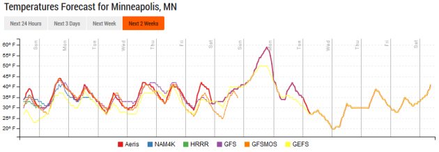
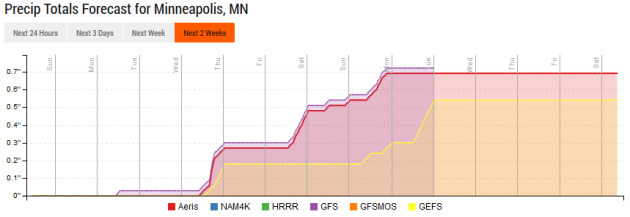
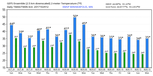
Minneapolis Temperature Outlook
_________________________________________________________________
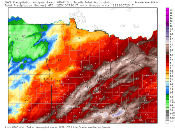
October Rainfall So Far...
It's been a fairly wet October with many areas seeing 2" to nearly 4" of liquic, but a few locations have seen 4" to 8"+ of liquid, some of which included snow!
 __________________________________________________________________
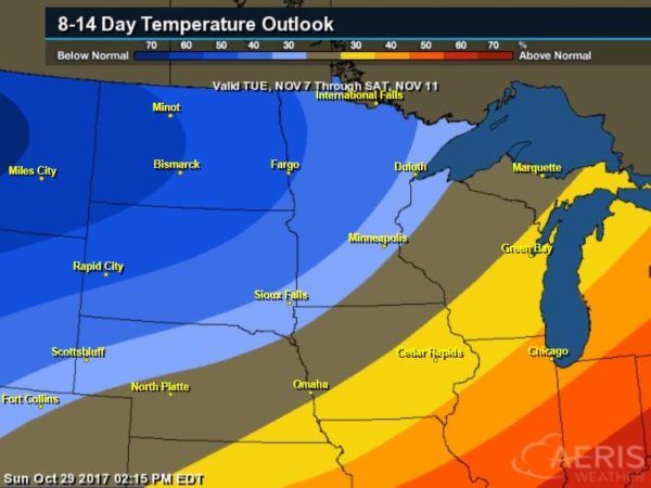
6 to 10 Day Temperature Outlook
According to NOAA CPC, there is a good chance that below average temps will continue across parts of the Midwest into the first part of November.
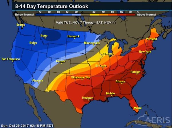
6 to 10 Day Temperature Outlook
According to NOAA's CPC - much of the nation will remain above average with the exception of the Intermountain West, where cooler than average temps will be found
_____________________________________________________________________
"Balloon Watches for Sharks and Hurricane Damage"
"Tethered balloons equipped with sophisticated cameras can survey threats and damage from an elevated perspective. A versatile new technology called smart balloons can help monitor two potentially threatening dangers -- great white sharks and high-category hurricanes. Each balloon, tethered to the ground, floats high above the seascape or landscape while its cameras shoot still photos or stream video of the scene below. Land-based operators can order the balloons' cameras to zoom in on eye-catching items. The balloons' cameras can detect sharks close to shore, allowing lifeguards to warn swimmers and beachgoers of their presence. The cameras can also track damage from hurricanes on land and water, thus permitting local authorities to prioritize cleanup tasks. And they can spot disturbances in crowds at sports events and other large gatherings, and identify the individuals responsible. John Ciampa, CEO and founder of the Miami company Altametry, began working on the balloons six years ago, with a grant from the National Science Foundation and help from two universities in Florida. He developed what the company calls SmartBalloons."
______________________________________________________________________________
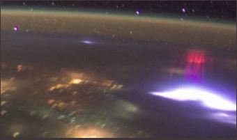
"Blue jets, red sprites and other flashes"
In recent years, the International Space Station has given astronauts the chance to photograph transient luminous events – or TLEs – natural light shows produced at the tops of thunderstorms. Two weeks ago, we published a photo by Paul Smith of an awesome red sprite over Oklahoma. Red sprites are a type of transient luminous event (TLE), different from the more familiar lightning that takes place in the troposphere, or lowest part of Earth’s atmosphere. A related phenomena are the blue jets, which pulse from the tops of intense thunderstorms and reach up toward the edge of space. In 2015, European Space Agency (ESA) astronaut Andreas Mogensen photograped blue jets from the International Space Station. A subsequent analysis of the video footage by researchers at Denmark’s National Space Institute – published in early 2017 – revealed some amazing results! Olivier Chanrion, lead author of the publication reported:
_______________________________________________________
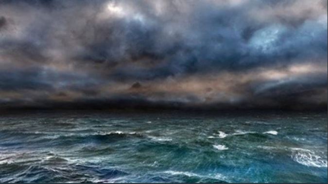
"Was the Extreme 2017 Hurricane Season Driven by Climate Change?"
"Global warming already appears to be making hurricanes more intense. Summer and fall 2017 saw an unusual string of record-breaking hurricanes pummel the U.S. Gulf Coast, eastern seaboard, Puerto Rico and the Caribbean. Hurricane Harvey brought unbelievable floods to Houston. Irma, one of the two strongest hurricanes ever recorded in the northern Atlantic,wreaked havoc on Florida and many Caribbean islands. Maria devastated Puerto Rico and the Virgin Islands. The destruction begs the question: Has climate change influenced these extreme events? Hurricanes can be difficult to decipher, but experts are gaining a sense of what our warming world might mean for monster storms in the U.S. and worldwide."

________________________________________________________________________
"La Niña forecast may mean even worse Atlantic hurricanes in 2018"
"Following a barrage of storms – such as Harvey, Irma and Maria – it seems like this year’s hurricane season may be one for the record books. But the Atlantic Ocean may be roiling even more strongly next year, if the La Niña that looks likely to arrive in the coming months persists into next summer. There is a 55 to 65 per cent chance that La Niña will make an appearance before the US winter sets in, according to the winter outlook released last week by the US National Oceanic and Atmospheric Administration. La Niña is one of two phases of the El Niño Southern Oscillation (ENSO), a repeating change in surface ocean temperatures near the equatorial Pacific that affects climate patterns from the Pacific to the Atlantic. The two ENSO phases act like a seesaw between the two oceans, intensifying hurricane activity in one while weakening it in the other. La Niña conditions tend to enhance such activity in the Atlantic and reduce it in the central and eastern Pacific, whereas El Niño does the opposite."
________________________________________________________________________________
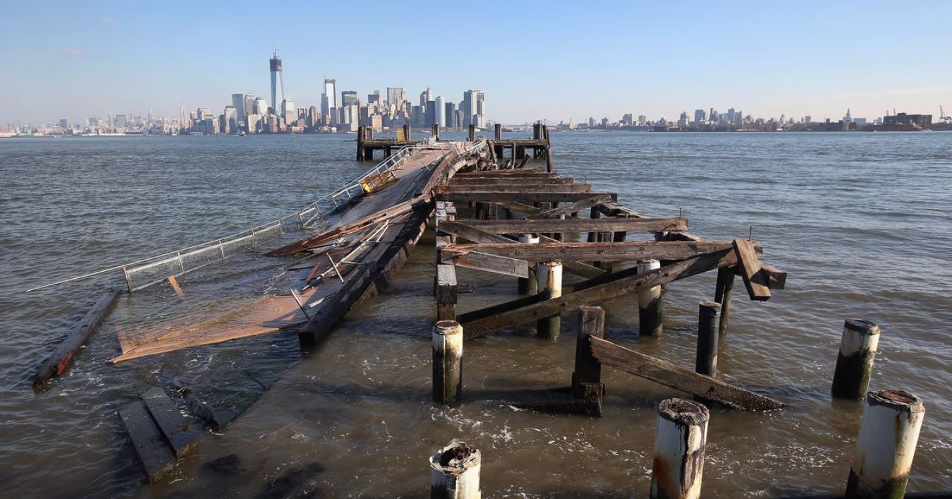
"Here's how New York City is preparing for the next Hurricane Sandy"
"Hurricane Sandy, which happened five years ago this week, notably exposed the dire need to improve New York’s infrastructure so that it can stand up to the increasing threat posed by sea level rise. In the years since the storm, city and state agencies have put many different resiliency efforts into place with the goal of protecting NYC from future—and undoubtedly more frequent—storms. Many of those measures are now in various states of completion. The reconstruction of the Rockaway Boardwalk, for example, has already wrapped up. But others—like a plan to bring new energy generation capacity to Hunts Point, where a power outage would be disastrous for food-processing facilities—are still in the conceptual phases. Perhaps the most high-profile of these resiliency efforts were those awarded federal funds through the Department of Housing and Urban Development’s 2013 competition Rebuild By Design. “New York can benefit from a lot of wisdom tempered by calamity,” wrote New York magazine architecture critic Justin Davidson in 2014, when the competition’s local winners were announced. And it rings true: Danish architect Bjarke Ingels’s firm proposed a series of levees that was awarded a $335 million slice of the disaster-recovery pie, and that are now being designed."
______________________________________________________________________________
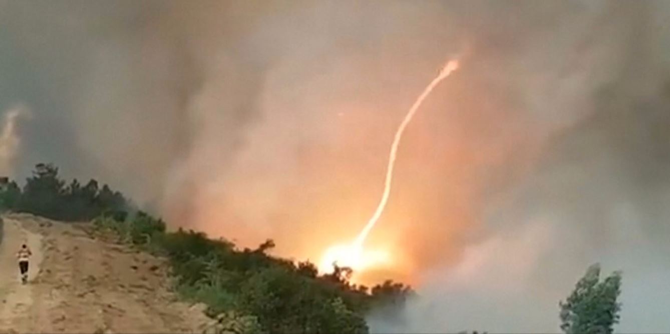
"A 'firenado' is a real thing — here’s how the dangerous phenomenon forms"
"Firenados, or fire tornados, can form out of the winds and extreme heat of wildfires. Firenados can move quickly and reach temperatures of 2000°F, so even though they normally last just a few minutes, they can cause severe destruction. Following is the text of the video. This is a "firenado," or fire tornado. It formed out of wildfires in Arganil, Portugal. Firenados are swirling columns of fire, but they aren't really tornados. Tornados result from conditions high in the atmosphere. Firenados form because of conditions on the ground. Hot, dry air rises rapidly and forms a column. That column of air begins to swirl. As it gains speed, it picks up flaming embers and debris. Then it becomes a blazing tower of fire. Firenados are similar to dust devils, but with fire instead of dust. They can reach temperatures of 2000°F and be hundreds of feet tall. They normally only last a few minutes, but that's enough time to cause serious damage and endanger lives."
____________________________________________________________________________
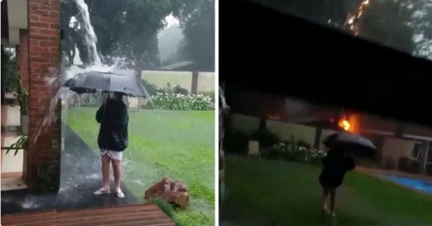
"Video Captures Moment 12-Yr-Old Boy Nearly Struck by Lightning While Playing in Water with Umbrella"
"A close call for one boy in Argentina was caught on video by his mother, and the dramatic footage provided by AccuWeather has spread widely via social media this week. According to the New York Post, the incident occurred in the city of Posadas as the 12-year-old stood under a drainpipe while holding an umbrella during the Oct. 21 storm. Shortly after the boy took a step into the yard, the video reveals a bolt of lightning struck perilously close to him. Reports indicate the bolt hit a nearby tree and set a portion of fence on fire. The footage cuts out at that point as his mother, Carolina Kotur, drops the phone she had been using to record."
_____________________________________________________________________________
Thanks for checking in and don't forget to follow me on Twitter @TNelsonWX