* Isolated severe storms possible (here) from late tonight into Friday.
* Much cooler, drier, more comfortable front arrives by Sunday.
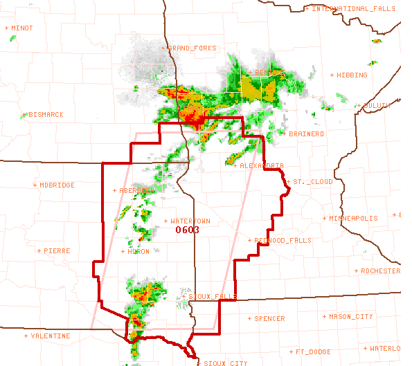
Tornado Watch. SPC has most of southwestern and parts of central Minnesota in a tornado watch until 10 pm. The watch includes Redwood Falls, Willmar, Alexandria and Detroit Lakes. The Twin Cities metro is not in the watch area, but a few strong/severe storms are possible locally from late tonight into much of Friday as a slow-moving cool front approaches from the Dakotas.

 Heat Advisory. The NWS has the Twin Cities metro and all of southcentral and southeastern MN under a heat advisory - the combination of highs in the mid 90s + dew points in the mid 70s will make it FEEL like 100-105 F this afternoon. Slow down, drink plenty of fluids, and watch for symptoms of heat exhaustion and heat stroke later today.
 Free Sauna. Yesterday was another sizzling day, 91 at St. Cloud, 92 at Redwood Falls, a steamy 93 in the Twin Cities, just 4 degrees away from an all-time record.
 Summer Soaker. The NWS has a new on-line tool that allows you to zoom into any county in Minnesota to get the latest (text) reports of precipitation, highs and lows. Pretty slick. You can see a 4.85" bulls-eye over downtown Minneapolis, 1.5 to 2.5" in the Egan area, 2.6" at Cottage Grove, 2.85" at Vadnais Heights and 2.46" at Golden Valley.
* 93 F. high on Wednesday, 4 degrees shy of a record, 11 degrees above average.
* 95 F high predicted later today, heat index (factoring dew points near 75) may reach 100-103 by mid afternoon.
* Slight risk of severe storms later today.
* Nearly 2.5" rain predicted from late tonight into Friday night.
* Cooler front arrives for the weekend with a BIG drop in humidity.

Paul's Conservation MN Outlook for the Twin Cities and all of Minnesota
Today: Plenty of hot sun, sticky. A few strong/severe storms possible late in the day. Winds: SE 10-20. High: 95 (Heat Index near 100 by mid afternoon).
Thursday night: T-storms likely, locally heavy rains - a few strong/severe storms possible. Low: 75
Friday: Muggy with more showers and storms - more heavy rain possible. Low: 87
Saturday: Partly sunny, breezy and less humid. Brief PM shower possible up north. Winds: W 10-20. High: 84
Sunday: A mix of clouds and sun, still comfortable. Winds: NW 10-20. High: 79
Monday: Bright sunshine, low humidity - still pleasant. High: 80
Tuesday: Unsettled with another round of showers and T-storms. High: 78
Wednesday: Clearing, more like September. High: 76
This doesn't look like Minnesota - it's looking more like Bangladesh out there lately. Hot, steamy, stifling sunshine - hard to take a breath it's so muggy, so "close" out there. And then just when you feel you can't take it any more (and you're on the verge of breaking down and having a "Jet Blue Moment) a spinning, rabid-looking "supercell" thunderstorm-from-hell roars into view, spitting hail and various black, spinning, whirling appendages. Suddenly you feel like an extra in the Wizard of Oz. Either incandescent sunshine (and neighbors whining about the dew point) - or - apocalyptic thunderstorms (and neighbors screaming - running for their lives). What a choice. What a summer.
Tuesday night I made the mistake of thinking I could outrun the tropical deluge - went to see a movie ("The Other Guys") with my youngest son. We ran 100 yards (record time) and I thought I was going to drawn - walked into the heavily air conditioned theater soaking wet, dripping from head to toe, laughing (or were we weeping?) I have NEVER been as wet as I was Tuesday night. The movie was pretty good, btw. Best Will Ferrell movie since "Anchorman" if you ask me. Not too many people ask me for movie reviews, come to think of it. Sorry.
 Tuesday Deluge. Have you dried out yet? Officially 4.85" of rain drenched downtown Minneapolis Tuesday night, so much rain that people were seen swimming in the streets! A record 24-hour rainfall was reported at MSP International: 2.47". Eden Prairie picked up 3.42" with 1.34" for St. Paul. All those yellow smudges are 2"+ rainfall amounts, the red shading shows 4" Doppler estimates. What was even more impressive than the rainfall amounts was the lightning, nearly continuous cloud-to-ground lightning strikes, thousands of them in just a couple of hours.
I'm still recovering from Tuesday night's incredible thunderstorm display. Earlier in the day SPC issued a tornado watch - there were no reports of tornadoes, but the lightning was intense and spectacular, flashes of blue, red and green. I don't think I was hallucinating - I noticed flashes of color, probably the result of ultra-high humidity levels coupled with ozone and other pollutants lingering over the metro area. The big story Tuesday: the rain. A rain gauge in downtown Minneapolis filled up with 4.85". MSP International reported a record-setting 24 hour rainfall: 2.47" fell in Richfield. Eden Prairie was swamped with 3.42", while St. Paul picked up an almost reasonable 1.34". Much of the metro area picked up nearly a MONTH'S worth of rain in about 4-6 hours Tuesday. I saw 3 separate storms on Tuesday, early morning, late afternoon, again late evening. That's the first time I can recall 3 separate outbreaks of storms in one afternoon/evening. What the...? When there's this much water in the air (and the atmosphere is this unstable with unusually cold air floating 5-7 miles overhead) it doesn't take much to turn otherwise tame updrafts into full-blown thunderheads, towering "cumulonimbus" clouds sprouting 50,000 to 60,000 feet into the sky, a wall of water.
 Slight Risk. Most of Minnesota is in a slight risk of severe storms later today, the best chance of hail, straight-line winds and an isolated tornado will come over western and central Minnesota, but storms could still be close to severe levels when they reach the metro area late Thursday and Thursday night.
We got a nice break Wednesday (if you call 93 a break) - nice to see blue sky (without the red blobs on Doppler radar or the sirens going off down the street). Another ripple of storminess in the upper atmosphere may shove a few strong/severe storms into western MN by evening (slight risk of severe storms across the western and central counties of Minnesota). Friday may bring a better chance of severe storms and embedded downpours, especially south/east of St. Cloud. One model prints out 2-4" of rain for some towns in southeastern MN Friday into Saturday morning.
The good news: the cooler front sparking all this foul, thundery weather will shove the heaviest weather towards Chicago by Saturday, skies clear statewide, a west/northwest breeze tugging cooler, drier, MORE COMFORTABLE air southward out of Manitoba. By Sunday there will be HALF as much water in the air as dew points drop into the 50s - we'll all be breathing easier within a few days.
Get ready for a string of 70s and low 80s next week, a stunning Monday (high pressure overhead - blue sky and light winds) giving way to another round of showers/storms Tuesday, followed by an even cooler, more comfortable frontal passage by Wednesday. By the middle of next week folks up north may be reaching for sweatshirts, the first true sign of September showing up on the weather maps. By Sunday-Monday people may be waving at me with all their fingers.....can't wait.
 Hints of "Danielle." The tropical depression forming in the Gulf of Mexico side-swiped Miami, Florida with some wild-looking thunderstorms yesterday. Check out the rain (and hail) underneath that towering thunderhead.
 One Big Loop? The latest models are hinting that "Tropical Depression 5" may turn into a minimal tropical storm before coming ashore over Louisiana or Mississippi, and then proceed to do one great big 3 day loop, winding up back in the Gulf of Mexico by Monday. Good grief. It just underscores the wild and wacky summer we're experiencing. As of late Wednesday night the depression seems to be dissipating altogether - it's still unclear whether this tropical disturbance will reach tropical storm status - increasingly doubtful.
 Shelf Cloud. Check out this apocalyptic front approaching a beach in Helsinki, Finland. Yep, if you see something like this moving in - might be time to get off the beach (in a hurry).


 Biblical Flooding. Ames, Iowa was transformed into an island yesterday, after nearly 9" of rain fell Tuesday. I-35 was closed, so was Highway 30 - you couldn't get into our out of Ames. 30 people were trapped at the local Walmart store. The Des Moines area has been plagued with 4 flash floods in less than a week. More on the historic flooding here, some incredible photos here.
 Aerial Views of Pakistan Flooding. Speaking of epic flooding, it's been described as the worst flooding in the country's history, the before and after satellite views show the extent of Pakistan's misery - both the Indus and Sakkur rivers well out of their banks.
 Why So Extreme? A BBC meteorologist explains the strange contortions in the jet stream responsible for Russia's historic heat and drought, possibly the worst in 1,000 years of record-keeping here.
* Killer Heatwaves and Retreating Ice Sheets Raise Climate Alarms. Another article that attempts to connect the dots. The recent rash of floods, heat waves and accelerated ice-melt in Greenland has scientists wondering whether this is a fluke, or a symptom of a larger trend?
 Massive Ice Chunk Threatens Oil Platforms, Shipping Lanes. Since 1970 temperatures in the Arctic have risen 4.5 F, more than 3 times the global average. The recent 100 square mile chunk of ice that just broke off from the Petermann Glacier in Greenland may last for weeks, even months, eventually drifting far enough south to threaten shipping lanes and oil platforms in the North Sea. The latest on the "ice island" is here.
* Take Climate Change Off The Back Burner - And Do It Now. Click here to read an editorial in the New York Daily News.
No comments:
Post a Comment