Todd's Conservation MN Outlook for the Twin Cities and all of Minnesota
MONDAY: Shower or sprinkle early, then clearing. Windy. Winds: WNW 10-25 Gust to 35 mph. High: 57
MONDAY NIGHT: Mostly clear and breezy. Low: 40
TUESDAY: Plenty of sun, distractingly nice. High: 67
WEDNESDAY: Mostly cloudy with scattered rain, isolated rumble of thunder? Low: 46. High: 57
THURSDAY: Lingering showers, cool & damp. Low: 40. High: 51
FRIDAY: A cold rain, mixing in with a little snow? Windy and foul. Low: 36. High: 47
SATURDAY: AM flurries or spits of cold sprinkles, slow PM clearing. Low: 33. High: 49
SUNDAY: Sun and clouds mix, less wind and a little warmer. Low: 30. High: 54
I Snapped This Picture in St. Michael, MN at County Rd. 141, which flooded AGAIN this spring. This was the 2nd crest. Most Rivers in central Minnesota saw/will see their 2nd crest as high as the last one over the coming days, but Spring flooding along rivers should subside within the couple/few weeks.
Mississippi River @ St. Paul to See 2nd Crest This Week at 19.3 ft. by Thursday
Major Flooding is Occurring & Major Flooding is Forecast Through the Week.
What a wild weekend of weather we had! Our first real round of showers and thunderstorms moved through overnight Saturday across the southern two-thirds of the and we managed to sneak up to 76 muggy degrees, officially at the MSP airport on Sunday, which qualifies as the warmest day of the 2011 year so far and the warmest day since since October 11th, nearly 6 months ago. Thankfully, the Metro missed the severe weather, but I fear it'll be an active Spring for us!
The Weather Set Up on Sunday
Take a look at the massive temperature swing across the state on Sunday afternoon. Temperatures warmed into the 80s, while temperatures behind the front were in the 40s! That's a 40F temperature swing across the state!! Generally, when there is such a big temperature difference or such a short distance, SOMETHING is going to happen.
A Peak at the Radar Sunday Afternoon
The storms that developed along the cold front yesterday exploded across western Wisconsin and quickly became severe producing large hail, damaging winds and even tornadoes. Have a look at the radar from Sunday at around 5pm.
Storms Via Satellite
Our wild Spring weather will continue with another goofy looking storm headed our way by the end of the week, which may shake out a little snow by Friday... HUH? Yes, I said snow... I can't believe it either, but temperatures aloft will cool enough as a slow moving storm settles into the Upper Midwest by the end of the week to support a cold rain, mixed with some wet snow.
Before we get too overly concerned with that, let's focus on our decent spring weather today and tomorrow. Winds will continue to be breezy today, but at least the sun will be out. Tuesday will harbor lighter winds, sunshine and temperatures in the upper 60s. It'll be a day you don't want to waste indoors, try to get if you can. Have a good day - Todd Nelson
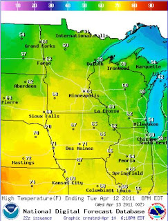
Tuesday's High Temps
Tuesday will be the nicest day of the week with sunshine, lighter winds and distractingly mild temperatures.


No comments:
Post a Comment