THURSDAY: Light snow moves out by late morning. Total accumulations up to 1" possible, mainly to the south of the Twin Cities. Breezy with a bite to the air. High: 31
THURSDAY NIGHT: Clear, breezy and cold. Low: 13
FRIDAY: Cold and quiet start. Lots of sun early, then increasing clouds through the afternoon. High: 30
SATURDAY: Possible 'bigger' snow event developing 'somewhere' in the Upper Midwest. Best chance for a shovelable/plowable snowfall southeast of the Twin Cities. At this point, there's a chance of snow in the Minneapolis/St. Paul area with the best of 'heavier' snow setting up in Southeastern MN. Low: 20. High: 30
SUNDAY: Lingering light snow chances early, then another shot of light snow as another clipper drops south of the border by late afternoon/evening. Low: 17. High:27
MONDAY: Windy, feels like December! Few scattered light snow showers possible early. Low: 16. High: 26
WEDNESDAY: Partly sunny and cold with snow flurries possible. Low: 15. High: 28
Happy December and happy first day of Meteorological Winter! Today is the start of the coldest three month, on average, for the northern hemisphere. The 2011 Meteorological Fall was characterized by its very dry and warm ways. The Twin Cities ended up nearly 6 inches behind normal rainfall, which has really taken its toll on some of the local rivers, lakes and ponds. Low water levels may have those fun little natural hockey rinks, in marshy swamps near you, in jeopardy as things start to freeze up. Some may have to resort to seeking out local outdoor ice rinks or to making their own this year. November also boasted one of the top ten warmest November on record in the Twin Cities with temperatures nearly 5.5 degrees above normal. How fitting, on the first day of Meteorological Winter, some of us are getting snow. It won't be enough to turn everything white, but we're on our way. The extended weather models are picking up on a more sinificant chance of snow developing over the weekend. It's still early and things could change, but a plowable snowfall event is looking more and more likely for some in the Upper Midwest... Stay tuned! Meteorologist Todd Nelson.
WOW - Driest Autumn On Record For MSP This Year, Only 1.35" of Precipitation!
Old record was fall of 1889 when area got just 1.54 inches of precip.
Average precip for fall is:7.26 inches.
Difference: 5.91 inches
Precip totals for 2011
September: .36 inches
October: .70 inches
November: .29 inches…
Total: Just 1.35 inches of Precip in 2011 during these three months.
Severe Drought Continues...
The picture above is from Northiowa.com - where Mason City, IA is experiencing low water problems like much of central and southern Minnesota. However, in Mason City, the low water problem has enabled them to remove silt from a nearby pond - East Park.
Michigan State University in East Lansing Michigan
This was the scene from Michigan State University on Wednesday after 7" to 9.5" of snow fell Tuesday - early Wednesday.
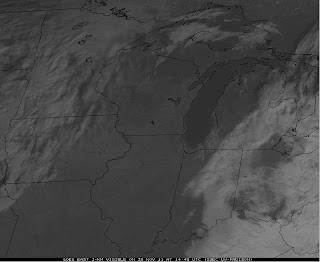
Snow Seen From Space
This was the view from nearly 23,000 miles high on Wednesday looking at the heavy snow swath across parts of Indiana and lower Michigan. Some spots got up to 10"
Another View From Space
This is a high resolution satellite image of southern Lake Michigan, which shows the lake all churned up with sand and sediment seen along the southern shoreline. The storm whipped up strong winds and very large waves across the lake... You can also see the heavy snow swath across parts of Indiana and lower Michigan.
Heavy Snow Causes Jackson, Michigan Golf Dome to Collapse
"The first big snow of the season caused the Jackson Sports and Events Dome to collapse this morning. Owner Al Lefere said the wet, heavy snow caused the dome to sag overnight, and this morning when the pressure on the building was increased to make the snow slide off, it fell down through the dome instead."
Light Snow AM Thursday
After a little light snow potential and some light accumulations, our focus shifts into the weekend as another system develops. It's still early and things are likely to change, but let's take a look at what the model are saying:
GFS MODEL:
Less impressive for the Twin Cities as the heaviest stay southeast
Snowfall Accumulation
ETA/NAM MODEL
This model is a little more aggressive in bringing the moisture a little farther north, which would then mean more snow for the Twin Cities
Snowfall Accumulation
ECMWF MODEL
The European model almost splits the two model above... it's also important to note that this particular model has been the most consistent since this 'event' looked possible last weekend/early this week. At this point, I would lean more towards the ECMWF with forecasting this upcoming event.
What Does This Mean?
This IS a dilemma... it always is! So many models and so many options. It's important when dealing with potential systems and snowfall events to see how things develop and see how certain weather model solutions converge or diverge over time. I am happy to report that the majority of the weather models are starting to converge, but it's also important to note that the system is still out west in the high elevation, which once it drops out into the southern Plains on Friday, could change entirely.
Storm Placement Midday Thursday
Storm Track Thru Early Saturday
That's all for today, thanks for checking in and have a wonderful rest of your week! Stay tuned on the upcoming 'potential' snowfall event. Don't forget to follow me on TWITTER!
-Meteorologist Todd Nelson-


No comments:
Post a Comment