78 F. high in the Twin Cities Thursday.
70 F. average high on September 19.
76 F. high on September 19, 2012.
.18" rain fell at MSP International yesterday.
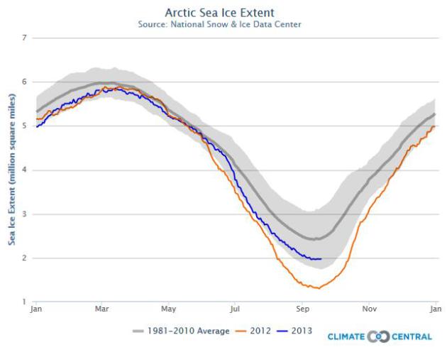
6th Lowest Arctic Ice Levels On Record. Graph above courtesy of
Climate Central; details below.
Cool and Quiet
Considering
Colorado's Front Range is digging out from a 1 in 1,000 year flood and a
Super Typhoon is steamrolling toward Hong Kong, we don't have much to
whine about.
Drought is hanging on like a low-grade fever. I'm
hoping we get a few good soakings to replenish topsoil before winter
frost freezes the ground in less than 2 months. Gulp.
51 percent
of Minnesota is in a moderate drought, down from 55 percent a week ago.
But a stain of severe drought stretches from central Minnesota to the
northern/eastern suburbs of the Twin Cities. Remind me not to complain
about showers anytime soon.
Today will be a subtle yet blunt
reminder that the sun is as high in the sky as it was in late March.
Canada is catching a cold, sneezing cool reminders south of the border.
Although no hard frosts or f-f-f-flurries are in sight looking out two
weeks today will feel like October: a smear of lumpy stratocumulus
clouds, a nagging northwest wind whipping up a little early-season wind
chill at evening football games.
Blue sky returns this weekend.
Your furnace may kick on Saturday, but highs rebound to 70F Sunday;
ECMWF model guidance hinting at a few 80s late next week.
At least one more summer relapse.
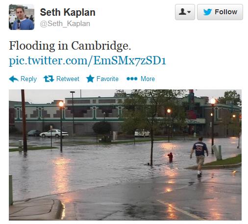
More Whiplash. From flash drought to flash flood. Blink, sneeze, hiccup, and you'll miss the change in the weather. Thanks to
Seth Kaplan and the Twin Cities National Weather Service for this image of extensive street flooding in Cambridge Thursday morning.
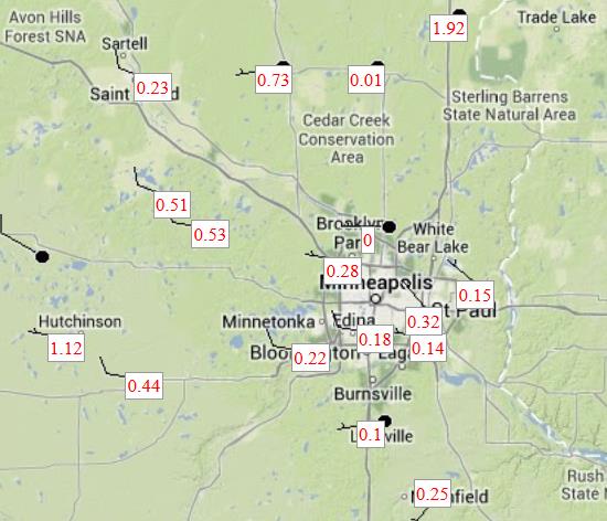
Thursday Rainfall Amounts.
MesoWest data shows .1 to .3" of rain from Thursday morning's squall
line, heavier amounts farther north with .73" at Princeton and 1.92" of
rain reported at Rush City.
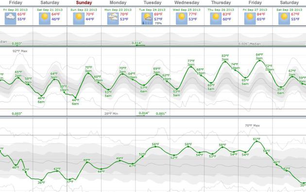
Cool Start - Warm Finish.
ECMWF guidance shows 60s today and Saturday, followed b another slow
warming trend next week, another run of 70s with a chance of a few
80-degree highs by the end of next week. Our warm dry bias continues for
at least another week.
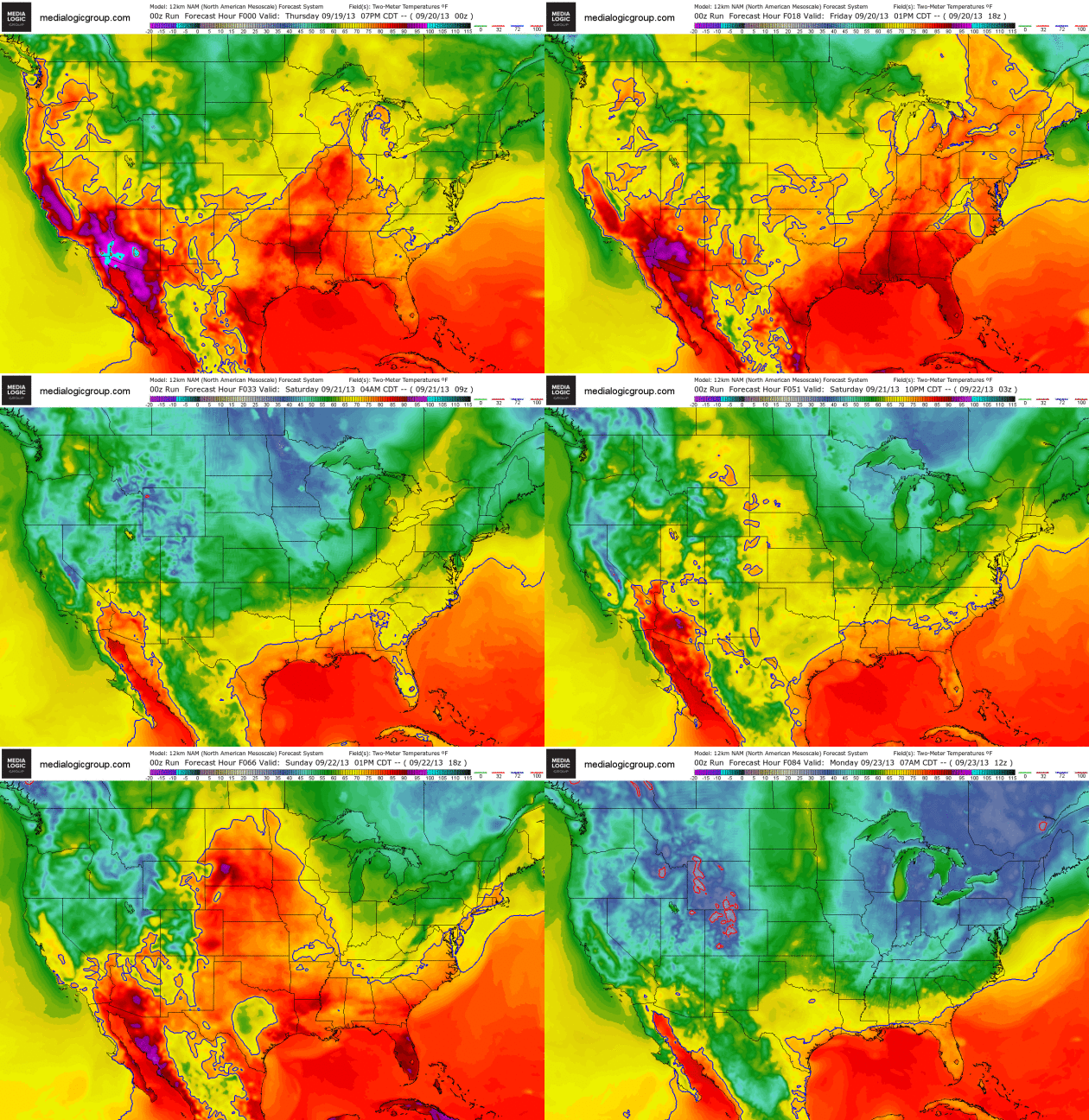
Waves Of Canadian Air.
Cool air pushes south into the Midwest and Great Lakes today, preceded
by a band of strong T-storms, followed by light jackets and sweatshirts
by Saturday morning - pushing into the Northeast by the weekend. Another
warming trend returns next week as the jet stream buckles and a ridge
of high pressure pushes north. 4 km. temperature forecast courtesy of
NOAA and Ham Weather.
342.
August was the 342nd consecutive month in a row of global land/sea
temperatures warmer than the 20th century average. I know, just another
coincidence. I also try to put this year's Arctic ice loss, not as
severe as 2012, into perspective in
Climate Matters: "
WeatherNationTV
Chief Meteorologist Paul Douglas goes over the climate highlights of
August. Record heat in Alaska, South Korea, and Australia and Arctic ice
melt make weather patterns get stuck. And that's not good for anyone."
Flood Maps, Models Inherently Flawed.
One of the many lessons of last week's 1 in 1,000 year flood: every
storm scenario is different, making it difficult ot use past storms to
predict future worst-case scenarios. Here's an excerpt of an interesting
angle on historic Colorado flooding from
Boulder Weekly: "
Flood
experts agree it’s impossible to be 100 percent prepared for natural
disasters, but last week’s flooding in Boulder County held some valuable
lessons for how to be more ready the next time the waters start rising.
They also say that flood modeling and floodplain mapping can only go so
far in predicting the paths that the water will take. Each disaster,
whether flood or fire, is unique, and when it happens, the silver lining
is that it adds to the body of knowledge and historical experience that
we rely on for making plans and predictions for future natural hazards.
Dave Gochis, a hydrometeorologist at the National Center for
Atmospheric Research in Boulder, says local leaders are vigilant about
updating floodplain maps, but those are based on “static depictions” of
storms, and “that is very reliant on what happened in the past...”

Fire And Rain, Colorado Edition.
The combination of a 14 year drought and recent wildfires may have made
a bad situation much worse. Here's a clip from a story at
Mother Jones: "...
Still,
the compounded damages from the cycle of wildfire and flooding could
very well be amplified on the Front Range in coming years. Climate
models foretell larger regional storms, and scientists have also
predicted bigger, more intense wildfires
in Colorado's future. "What is that going to mean for the people living
in the mouth of these areas?" wonders Hyde. If the 100-year flood that
turned Boulder inside out last week is any indication, living at the
base of the Rockies—while arguably worth it—isn't getting any less
complicated."
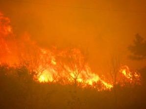
Photo credit above: "Flames from the High Park Fire west of Ft. Collins in June 2012." US Department of Agriculture.
Colorado Floods: What Happens To All That Water? Here's the intro to an interesting story at
Live Science: "
As
flood waters slowly begin to recede from central Colorado, new flood
warnings have cropped up downstream in Nebraska. Colorado's South Platte
River, which runs northeast from the middle of the state into the
southwest corner of Nebraska, has taken the burden of much of the record rainwater that hasn't already seeped into the ground..."
Graphic credit above: Flood Safety. "
Boulder's
500-year floodplain. River and flood water eventually discharges
northeastward toward Nebraska along the South Platte River."

Into The Wildfire.
Here's a clip from an article examining how residents of the west are
coping with increasingly large and devastating fires, and what new tools
and technologies may help in the years ahead, from the
New York Times Magazine: "
Lassen
Volcanic National Park, in Northern California, consists of more than
100,000 acres of wilderness and woodlands surrounding Lassen Peak, a
volcano named for a pioneer and huckster who guided migrants through the
area, that last blew its top in 1915, before anybody knew it was an
active volcano. Last summer the park, like much of the West, was in the
midst of a yearlong drought — which could be more accurately described
as the continuation of a decade-long drought that had merely been less
severe for a couple of years. A forecast of thunderstorms might seem
like welcome news for a firefighter in charge of so many acres of dry
forest — parts of the park can get so hot and dry during the summer that
rain evaporates before it reaches the trees — but Mike Klimek, the
firefighter in charge of the park on July 23, 2012, knew better..."

Atlantic Hurricane Numbers "Linked To Industrial Pollution".
Is aerosol pollution making clouds brighter, dampening hurricane
formation over the Atlantic in the process? Here's a clip from a recent
press release from the
UK Met Office: "The paper,
published in Nature Geoscience,
suggests aerosols may have suppressed the number of Atlantic hurricanes
over the 20th Century and even controlled the decade-to-decade changes
in the number of hurricanes. Researchers found that aerosols make clouds
brighter, causing them to reflect more energy from the sun back into
space. This has an impact on ocean temperatures and tropical circulation
patterns, effectively making conditions less favourable for hurricanes.
This interaction between aerosols and clouds is a process that is now
being included in some of the latest generation climate models..."
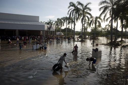
Mexico Flood: Tourists Evacuated From Acapulco.
USA Today
has a recap on the historic flooding gripping the western/Pacific coast
of Mexico, triggered by a series of tropical storms and weak
hurricanes. Once again systems stalled (just like in Colorado), pumping
out enormous quanitities of rain in a relatively short period of time: "
In
the wake of devastating twin storms that have caused more than 80
casualties and left thousands stranded, tourists are being evacuated
from flood-ravaged Acapulco, according to a statement by Javier Aluni,
Secretary of Tourism for the State of Guerrero. Passengers with
previously booked tickets on Aeromexico and Interjet are
being shuttled from the Forum at Mundo Imperial directly to planes at
Acapulco Alvarez International Airport (ACA) for flights to Mexico City.
The Mexican government is operating additional flights from the Pie de
la Cuesta Air Force Base. Priority is given to those with urgent medical
conditions, the elderly, women and children..."
Photo credit above: "
People
wade through waist-high water in a store's parking, looking for
valuables, south of Acapulco, in Punta Diamante, Mexico, Wednesday,
Sept. 18, 2013. Mexico was hit by the one-two punch of twin storms over
the weekend, and the storm that soaked Acapulco on Sunday - Manuel
-re-formed into a tropical storm Wednesday, threatening to bring more
flooding to the country's northern coast. With roads blocked by
landslides, rockslides, floods and collapsed bridges, Acapulco was cut
off from road transport." (AP Photo/Eduardo Verdugo)
Mesocyclone. Check out this
remarkable panorama shot of a spectacular shelf cloud approaching the Omaha office of the National Weather Service.
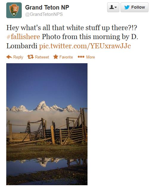
Hints Of What's To Come. Thanks to the
Grand Teton National Park Service for this tweet, which may get snow-lovers excited.
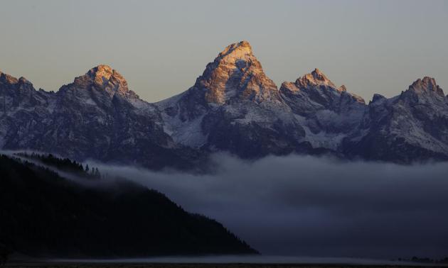
Grand Tetons Looking Even Grander.
This may be the only part of the Rockies that reminds me of the Alps in
Europe - thanks to Jackson Hole Mountain Resort for providing this
spectacular photo.
Astronomers Create Detailed 3-D Map Of Milky Way Core. Here is a clip from a fascinating article at
gizmag.com:
"Astronomers have used data from European Southern Observatory
telescopes to create a three dimensional map of the central bulge of the
Milky Way. The gigantic cloud at the center of our galaxy contains a
staggering 10,000 million stars (or thereabouts) and resides around
27,000 light-years away. Despite the relative proximity of the area,
prior to these new studies little had been confirmed concerning its
origin and structure. The main problem faced by astronomers when
observing the core of our home galaxy is the obscuring cloud of dust and
gas that sits between it and the Earth. Clouds such as this are a
common obstacle for astronomers, and are particularly common in star
formation regions where the scattered materials eventually come together
to form new stars..." (Image above: ESO).
Google Vs. Death. Here's a clip from an interesting story at
Time Magazine.
Google "life extension" and you may find out even more details about
the company's plans to let you live to be 125 (if you care to hang
around that long). "...
At the moment Google is preparing an
especially uncertain and distant shot. It is planning to launch Calico, a
new company that will focus on health and aging in particular. The
independent firm will be run by Arthur Levinson, former CEO of biotech
pioneer Genentech, who will also be an investor. Levinson, who began his
career as a scientist and has a Ph.D. in biochemistry, plans to remain
in his current roles as the chairman of the board of directors for both
Genentech and Apple, a position he took over after its co-founder Steve
Jobs died in 2011. In other words, the company behind YouTube and
Google+ is gearing up to seriously attempt to extend human lifespan..."
* more information on Google's new "Calico" life extension initiative from
Gizmag.
My Daughter's Homework Is Killing Me. If you think your kid is getting too much homework on a consistent basis check out this article at
The Atlantic.
21 Ways Supermarkets Control Your Mind. Yes, it's a conspiracy - to get me to buy crap I don't need.
BuzzFeed has the story - here's an excerpt: "...
Slow
music makes you shop for longer, whereas classical music makes you
spend more. Experiments have also shown that playing French music in the
wine aisles increases the sales of French wines..."
European Space Agency Might Send Robot Snakes Into Space. When science fiction catches up with reality: here's an excerpt from a story at
The Washington Post: "
Researchers
at the SINTEF Research Institute in Norway and at the Norwegian
University of Science and Technology are working on a feasibility study
for the European Space Agency (ESA) to see if snake-like robots could
help explore alien planets. They hope that the maneuverability of
snake-bots might assist more traditional rovers like Mars Curiosity get
access to different soil samples and access tight spots. No word yet on
if a robot Samuel L. Jackson will also be developed to respond if the
snakes escape onto a spacecraft..."
Photo credit above: "Robot snakes in space is sort of like real snakes on a plane, right?" (New Line Cinema).
TODAY: Mostly cloudy, windy & cool. Winds: NW 15-25. High: 65 (holding in the 50s far north).
FRIDAY NIGHT: Chilly for evening football games. Slow clearing. Low: 46
SATURDAY: Sunny, less wind. Dew point: 40. Winds: NW 10. High: 66
SUNDAY: Chilly start. Blue sky, milder by afternoon. Wake-up: 45. High: 71
MONDAY: Partly sunny, lukewarm breeze. Wake-up: 53. High: 72
TUESDAY: Early shower, then clearing. Wake-up: 57. High: 70
WEDNESDAY: Mostly sunny and warm. Wake-up: 53. High: 77
THURSDAY: Dig out the shorts? Summer rerun. Wake-up: 60. High: 82
Climate Stories....
Administration Presses Ahead With Limits On Emissions From Power Plants. Here's a clip from a story at
The New York Times: "
A year after a plan by President Obama
to limit greenhouse gas emissions from new power plants set off angry
opposition, the administration will announce on Friday that it is not
backing down from a confrontation with the coal industry and will press
ahead with enacting the first federal carbon limits on the nation’s
power companies. The proposed regulations, to be announced at the
National Press Club by Gina McCarthy, the administrator of the
Environmental Protection Agency, are an aggressive move by Mr. Obama to
bypass Congress on climate change with executive actions he promised in his inaugural address this year..."
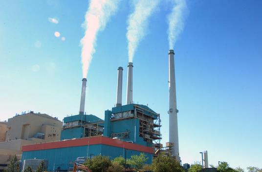
Photo credit above: Matt Brown/Associated Press. "President Obama has told officials that he wants limits on all plants, like one in Colstrip, Mont., by the time he leaves office."
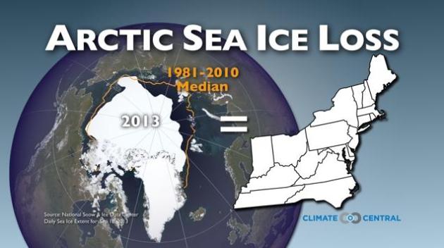
No, Arctic Sea Ice Has Not Recovered, Scientists Say.
Aerial coverage of ice has "recovered" from last September's record
low, but the volume and thickness continues to be in decline. Here's a
clip from an article at
Climate Central that puts things into stark perspective: "...
According
to data from September 18, Arctic sea ice extent was about 1.97 million
square miles, which is well above the level observed on the same date
last year, yet still well below the 1981-2010 average, according to the National Snow and Ice Data Center (NSIDC)
in Boulder, Colo. An official announcement of the sea ice minimum is
expected to come from the NSIDC within the next few days. The long-term decline in sea ice,
both in terms of the extent of sea ice cover as well as its thickness,
is largely due to warming caused by human activities and natural
variability, as the Arctic is warming at nearly twice the rate of the
rest of the globe. As has been the case in recent years, the sea ice at
the end of the 2013 melt season is unusually thin, which makes it more
susceptible to the influence of weather systems..."
Image credit above: Climate Central. "Arctic sea ice loss during the 2013 melt season was equivalent to losing the entire area of states from Tennessee to Maine."
Colorado Floods And Climate Change: The Elephant In The Room. Here's an excerpt from a story at
Huffington Post: "
There
have been many words to describe the flooding in Colorado over the past
week: horrific, catastrophic, unprecedented and biblical are some. To
illustrate the scale of the disaster, some numbers:
• Over 18" of rain have fallen in the Boulder area since last Wednesday.
• 7-11" of rain fell during a single 24-hour period.
• From north to south, 200 miles of Colorado were hit.
• 17 counties were affected.
• 30 bridges were destroyed.
• Over 1500 homes were destroyed and 18,000 damaged.
• Over 11,000 people were evacuated.
• Over 600 people still missing and
• 8 people confirmed dead.
The flooding has been classified as a 1000-year event,
meaning there was only a tenth of 1 percent probability (0.1 percent)
that it would happen in a given year. When an event this unusual and
extreme happens these days, one of the first questions people ask is:
"Was it because of climate change?"
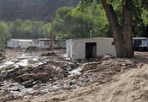
Photo credit above: "
This
photo shows flood-damage at the River Bend Mobile Home Park in Lyons,
Colo., on Thursday, Sept. 19, 2013. The recovery process has begun along
the front range as people clean out flooded homes and businesses. Local
governments are starting to clear debris and repair infrastructure." (AP Photo/Chris Schneider).
What's The Climate Change Context Behind The Colorado Floods? Here's an excerpt of a good explainer from
E&E Publishing: "...
According
to both Hoerling and meteorologists with the National Weather Service,
the conditions that led to this widespread, long-lasting rainfall
stemmed from a moist tropical air mass from the Gulf of Mexico that was
displaced into the region by air coming from the south. When the air
hits the mountains, it is moved upward rapidly and cools, causing
precipitation. An upper-level high-pressure system in the area to the
west pinned this weather in for about a week, so the rain kept falling.
What role does climate change play in any of this? Hoerling said in this
storm, the amount of precipitable water measured in the atmosphere was
record-high. Global warming is known to increase the amount of moisture
in the atmosphere, although the effect is not large -- perhaps a 3 to 5
percent increase in the precipitable water would be a "reasonable
estimate," he said. But what really caused the rain to fall the way it
did, for the amount of time it did, was the unusual atmospheric
circulation..."
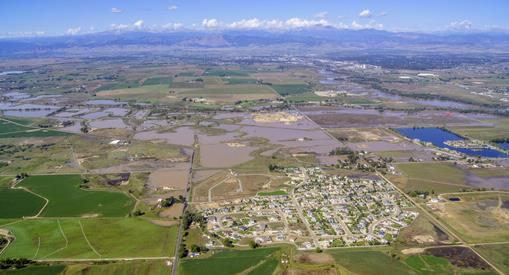
Photo credit above: "
This Sept.
17, 2013 photo provided by Ecoflight shows the result of flash floods
that inundated parts of the booming oil and natural gas patch in
northern Colorado's Weld County. Hundreds of natural gas and oil wells
along with pipelines are shut down by flooding in this key energy region
in Colorado, as state and federal inspectors are just beginning to
gauge the damage and looking for contamination from inundated oil fields." (AP Photo/Ecoflight, Jane Pargiter)
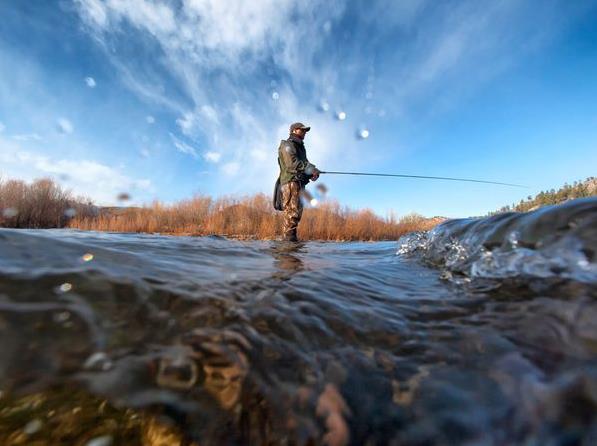
Climate Change Spells Trouble For Anglers. Here's a clip from an article at
National Geographic: "...
A new report,
published September 4 by the National Wildlife Federation (NWF)—one of
the country's largest environmental groups—backs up the anecdotal
evidence and explains the variety of threats that climate change poses.
Besides the closures themselves—which are typically the result of
droughts and earlier than normal melt of alpine snowpack—many rivers are
simply getting warmer. According to the NWF report, half of the major
American rivers surveyed in a 2010 study experienced "significant
warming trends over the past 50 to 100 years." Fish are sensitive to
temperature, explained Jack Williams, a senior scientist with the
conservation group Trout Unlimited
and a co-author of the NWF report, who describes a massive geographical
shift in fish species already underway. "Already, native trout have
been pushed around," Williams wrote in an email..."
Photo credit above: "An fisherman in Montana enjoying the river." Photograph by Jeff Hornbaker, Corbis.
Is Global Warming In A Hiatus. Here's a snippet from a long but interesting article from
The Conversation: "
On September 27 2013 the 5th Assessment Report by the Intergovernmental Panel on Climate Change
(IPCC) will be released. One part of this report will address the
so-called “warming hiatus”. This is the argument that warming has
stopped, with the further assertion in some quarters that we therefore
have nothing to worry about in the future. It is a fact, based on
observations of air temperature, that the rate of global warming
measured as surface air temperature has slowed over the past 15 years.
The last decade is still the warmest in the past 150 years...."
Photo credit above: "With low solar activity, a double-dip La Nina and more particles in the air, it should be much colder than it is." Les Chatfield/Flickr
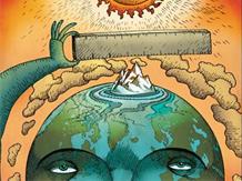
The Inevitability Of Sea Level Rise.
A little warming is no big deal? If you live within a few miles of the
ocean - any ocean - it will be a very big deal in the coming years and
decades. Here's a clip from
United Academics: "
There
is no doubt that for the next century, sea level will continue to rise
substantially. Small numbers can imply big things. Global sea level rose
by a little less than 0.2 metres during the 20th century – mainly in
response to the 0.8 °C of warming humans have caused through greenhouse
gas emissions. That might not look like something to worry about. But
there is no doubt that for the next century, sea level will continue to
rise substantially. The multi-billion-dollar question is: by how much?
The upper limit of two metres that is currently available in the
scientific literature would be extremely difficult and costly to adapt
to for many coastal regions. But the sea level will not stop rising at
the end of the 21st century. Historical climate records show that sea
levels have been higher whenever Earth’s climate was warmer – and not by
a couple of centimetres, but by several metres. This inevitability is
due to the inertia in the ocean and ice masses on the planet. There are two major reasons for the perpetual response of sea level to human perturbations..."
The Known Knowns Of Climate Change. Here's an excerpt of a good explanation of what we do know (vs. what is theory or conjecture) from
Project Syndicate: "...
We
also know beyond doubt that emissions from human activities have
substantially increased the amount of greenhouse gases (especially
carbon dioxide) in our atmosphere. When the first IPCC report was
published in 1990, the concentration of CO2 in the atmosphere had
reached 354 parts per million (up from the preindustrial baseline of 280
ppm). This year, the concentration of atmospheric CO2 crossed the 400 ppm line for the first time.
CO2 levels are already far higher than they have been in a million
years, as ancient air bubbles trapped in the Antarctic ice show.CommentsWe
know that the amount of greenhouse gases is rising due to our
emissions, and we know that this is causing warming. But how much? The
most telling number here is the “climate sensitivity” – that is, the
degree of global warming caused by a doubling of atmospheric CO2. IPCC
reports have consistently given a range of 1.5-4.5ºC (with a minor
exception in the fourth report, which gave a range of 2.0-4.5ºC)...."
Illustration credit above: Paul Lachine.
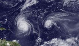
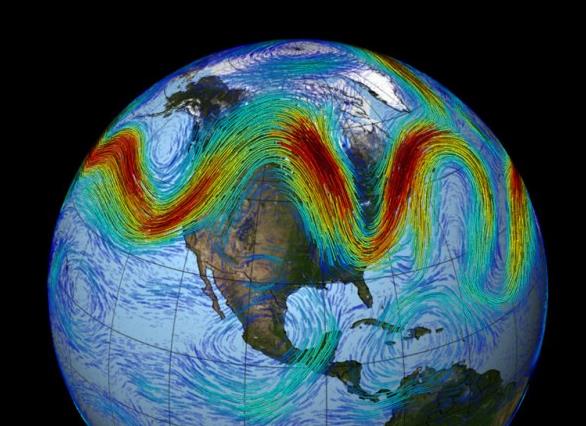
Weather Whiplash Is Like My Old, Broken Sprinkler.
Climate scientist Greg Laden uses his lawn sprinkler as a metaphor for
how the jet stream has been "whiplashing" back and forth, most evident
since record Arctic ice loss a year ago - here's a clip from his post at
scienceblogs.com: "...
Until
recently I had one of those sprinklers that wave back and forth with a
couple dozen high power streams of water. The water comes out of a bar,
and the bar oscillates back and forth and back and forth so there is a
long, linear, gentle rain storm that passes back and forth across the
lawn over the zone covered by the sprinkler. But when my sprinkler got
old it would get stuck sometimes. The bar would stop oscillating, and
the streams of water would create a long linear rain storm on one strip
of the law while the rest of the lawn simply got dryer. The broken
sprinkler did something that resembles the weather in the middle-ish
part of the United States for a week or so during September 2013. The
midwest got a “flash drought” during which no rain fell but it as hot
and breezy, while the Rockies and other areas got lots of rain from a
big storm that sat there for days and days without moving. The main part
of the storm was in Colorado but New Mexico got extra rain as well, and
after the storm left Colorado it moved north in the Rockies and wet
down Wyoming and Montana a bit as well (causing only some flooding)..."
Climate Change Is Not All Disaster And Uncertainty.
How do you quantify uncertainty and attribution when it comes to
climate change's impact on extreme weather events? How do you accurately
communicate what may be the most complex environmental risk we've ever
seen to the media, and ultimately the public? A few interesting ideas in
this post from Australia's
The Conversation: "
How does newspaper coverage affect how we view climate change? A new report
has estimated that 82% of articles about climate change are framed in
the context of “disaster” and “uncertainty”. The report’s lead author,
James Painter, notes that those dominant media frames may be doing us a
disservice because the public “finds uncertainty difficult to understand
and confuses it with ignorance.” Likewise, “disaster messages can be a
turnoff,” and the report therefore suggests that a better framing might
involve the language of risk. This, they suggest, would encourage focus
on the trade-off between the risk – and cost – of inaction, and of
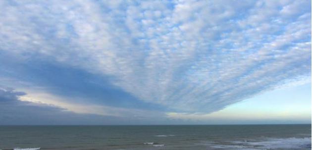
climate mitigation..." (Image: NASA).





This site is very important site. It is informative site too. It is very helpful to me. If you need any cleaning service
ReplyDeletethen visit this site.We are the affordable service provider in Australia. To learn more please visit our site...
http://cleanerssydneycleaning.com.au/