49 F. high Wednesday in the Twin Cities.
51 F. average high on October 30.
50 F. high on October 30, 2012.
.09" rain fell at MSP International as of 7pm yesterday.
Saturday night: don't forget to "fall back" 1 hour as we go back to standard time.
No accumulating snow for MSP and suburbs for at least the next 8-9 days.
"
Each
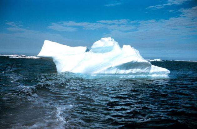
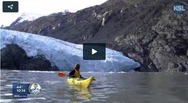
year Alaska is losing about 50 cubic kilometers of ice....That's (the
equivalent of) about three full Great Salt Lakes draining out of these
mountains ever single year." - Evan Burgess, glaciology expert. Links to the full report at KSL.com below. Image above: NOAA News.
September 2013 tied with September 2005 for warmest on record, worldwide (land and ocean). Source:
NASA.
Halloween Horrors
What
keeps me up at night? The specter of another historic & humbling
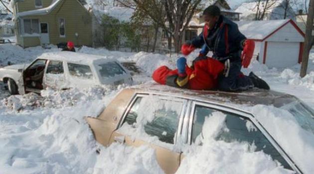
storm, similar to the 1991 Halloween Superstorm: 28.4 inches of snow
over 3 days & hip-deep drifts, followed by the earliest subzero low
ever recorded at MSP.
There was so much snow that I couldn't get
my Saab out of the garage. The Chief Engineer at KARE-11 had to bring
his Suburban (with a plow on the front) to rescue me. Not good when the
weatherguy can't get to the station to talk about the weather.
What
happened? A massive storm stalled off the coast of New England, forcing
Minnesota's storm to stall out over Lake Superior, prolonging the snow.
The models didn't catch this. Yes, when weather stalls bad things can
happen.
My take-away? The forecast is close much of the time, but
there will be events that stop us in our tracks. Expect more "I've never
seen THAT before!" moments.
The bulk of the rain stayed south/east of Minnesota; we dry out today with 40s for Trick or Treating.
A
cool & quiet weekend gives way to more rain Monday & Tuesday.
The risk of wet snow has diminished, in fact I see 40s & 50s into
mid-November.
Whoa. Look at the time. Excuse me while I change into my Miley Cyrus costume.
* image above courtesy of
The Star Tribune.
How Likely Are Severe T-storm Outbreaks On Halloween? We asked the experts at NOAA's SPC, the Storm Prediction Center. Here was their response: "
Greg
Carbin forwarded your request to me regarding Halloween severe events.
The short answer is that, while some severe thunderstorm activity is not
uncommon on Halloween, there have not been any major outbreaks in the
record since 1950. From 1950-2012 (63 years), there has been at least 1
severe report (tornado, wind gusts > 50 knots, or severe hail) in 27
of those years, though only one year (1992) has seen 100 or more total
reports on Halloween. Over the same period, there has been at least one
tornado report in 14 of those years, though only one year (2000) with 10
or more tornadoes. There have been 2 killer tornadoes on Halloween
since 1950 (each resulting in 1 fatality): one in Florida (Lee County)
in 1960, and one in Kansas (Osage County) in 1984. Hopefully this answers your question. Let us know if you have any questions or need anything else."
Andy Dean, Techniques Development Meteorologist
NOAA/NWS/Storm Prediction Center, Norman, OK.
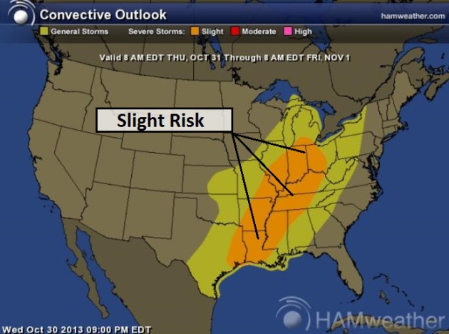
Halloween Severe Risk.
Unusual, but hardly unprecedented, an outbreak of severe storms is
possible later today from the Ohio Valley into Mississippi River Valley;
large hail and straight-line winds the greatest risk, but a few
isolated tornadoes can't be ruled out. Source: NOAA SPC and
Ham Weather.
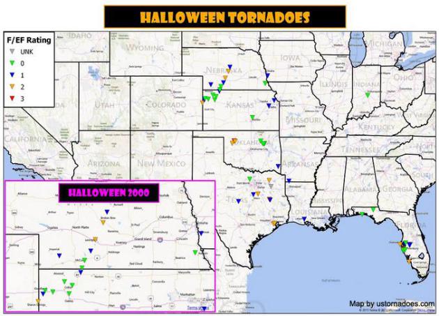
54 Confirmed U.S. Tornadoes On Halloween Day Since 1950. Here's a good recap of tornadoes on October 31, between 1950 and 2012, courtesy of
ustornadoes.com.
Graphic credit above: "
Halloween tornado data via the Storm Prediction Center." (Map by Kathryn Prociv).
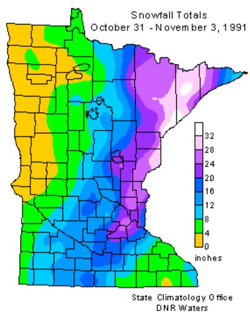
Halloween Blizzard Of 1991.
The Minnesota Climatology Working Group
has a good summary of the storm that humbled meteorologists between
October 31 and November 3, 1991, leaving behind 20-30+" of snow across
much of eastern Minnesota with 4-5 foot drifts reported. Here's a clip:
"...
As Halloween dawned back in 1991, some wintery weather was
anticipated but no one was expecting a blizzard. The National Weather
Service issued a Winter Storm Watch at 4:00 am on the 31st with a
potential of a foot of snow. The first inkling that the forecast
underprojected snowfall totals came when precipitation started falling
as snow at about 11:30am in the Twin Cities, much earlier than
anticipated. With the realization that the precipitation would be snow,
not rain, a Winter Storm Warning was issued during the day by the
National Weather Service in the Twin Cities and forecasters realized
there was a potential for a lot of snow. As the afternoon faded
into evening a surreal scene unfolded with kids attempting to trick or
treat wearing coats and boots and pumpkins becoming covered with a snowy
blanket. 8.2 inches of snow fell by midnight on the 31st at the Twin
Cities International Airport, the most for the entire month of October
on record for the Twin Cities..."
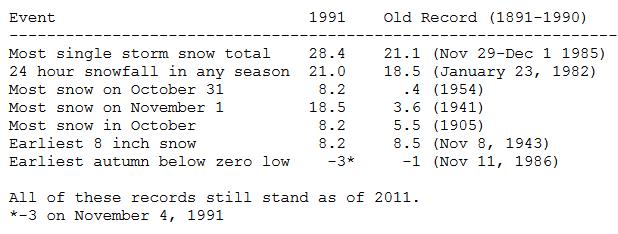
A Record-Smashing Storm.
Here is a list of the records that were shattered with this historic
snowfall in 1991. 28.4" of snow buried the Twin Cities, followed by the
earliest subzero low on record at MSP (-3F on November 4, 1991). I still
get chills thinking about this storm. Source: Minnesota Climatology
Working Group.
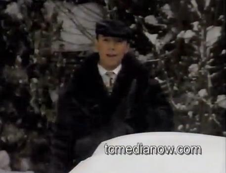
Nice Hat Paul. OK. I look like I'm 17 in this clip from 1991, but Tom Oszman at
tcmedianow.com
has done a superb job of editing together all the local TV weathercasts
and newscasts from the Halloween Superstorm into one video. If nothing
else it's worth seeing how young we all looked back then. That, and the
waist-deep drifts and horizontal snow in KARE-11's Backyard too.
Don't Hold Your Breath.
OK. This is a test. This is only a test, an experiment. I'm genuinely
interested to see if NOAA NCEP's CFS (Climate Forecast System) model has
any skill going out 45 days, perhaps to capture the trends, if
not specifics. Yes, I'm the same guy who told you that any weather
forecast beyond 10 days is more of a horoscope. My expectations are
(very) low, but our ace model-guru whipped this up yesterday, I did a
double-take, and thought, in the spirit of full disclosure, I should
share it with you. The model seems highly erratic after watching a few
runs, so my confidence level is EXCEPTIONALLY low. It shows a mostly
snow-free November for MSP, but a potentially plowable snow the first
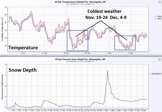
few days of December. The best chance of cold blasts: November 19-24,
again December 4-9. Circle your calendars. Will we have 6" on the ground around December 3? I seriously doubt it, but just in case, I want to cover my.....um...Doppler. Source: Ham Weather.
Mostly Snow-Free Start To November.
Here is the 12km NAM solution showing total snow accumulation into
Saturday night, enough to shovel and plow over the Rockies, maybe an
inch for upstate New York, but virtually snow-free east of the
Mississippi. Source: NOAA and Ham Weather.
Insert Yawn Here.
For the record I'm just fine with quiet weather spilling over into the
first 2 weeks of November. It just means I may be busier the latter half
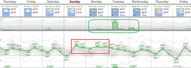
of November and December. ECMWF data shows highs mostly in the 40s into
late next week, maybe a 50-degree high or two early next week. Another
southern storm pushes rain back into Minnesota Monday and Tuesday.
Source: Weatherspark.
A Thunderous Halloween.
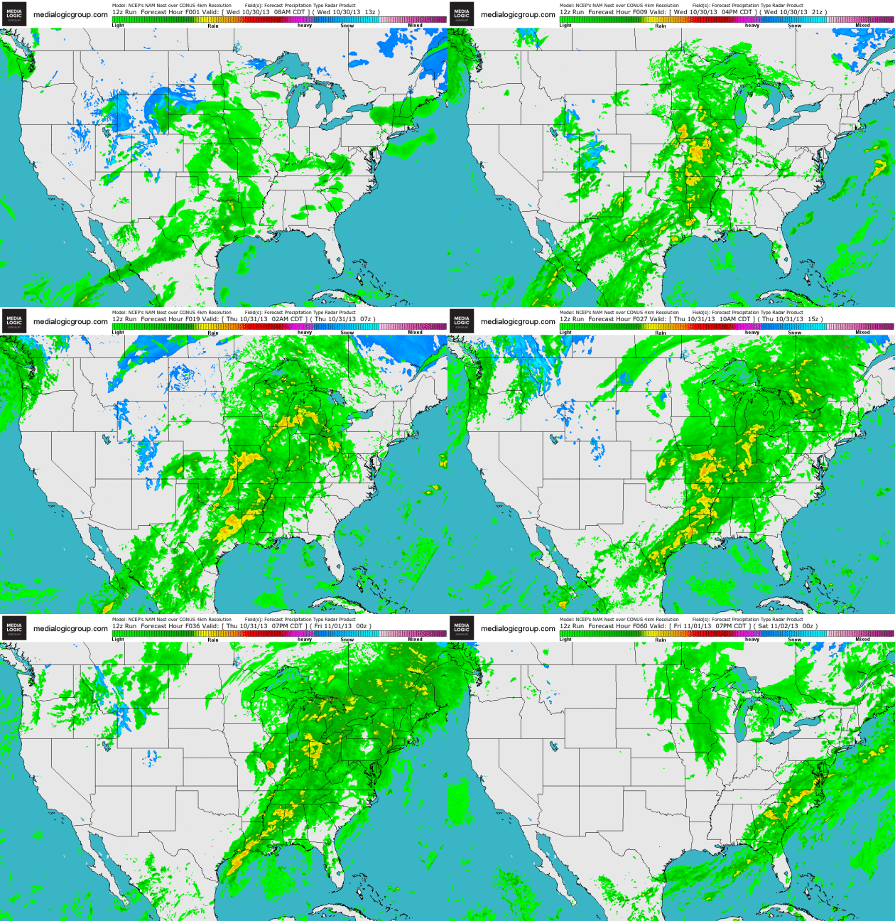
4km NAM model data shows a significant storm sloshing across the
Midwest into the Great Lakes and Ohio Valley, enough instability and
warm, moist Gulf air for strong to severe T-storms from Indianapolis and
Louisville to Memphis and New Orleans. Source: NOAA and Ham Weather.
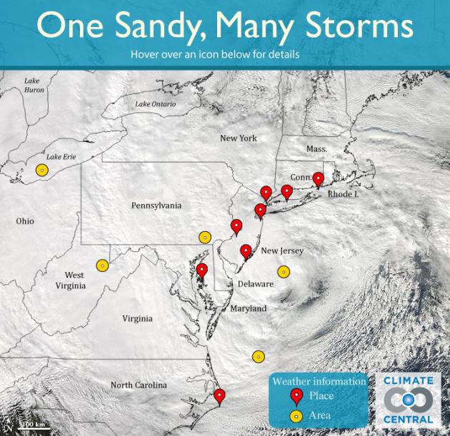
The Myriad Impacts Of Sandy Along The East Coast. Climate Central has a very effective
interactive display that allows you to see the level of destruction at various points along the Eastern Seaboard: "
Sandy hit the Northeast the hardest, but the storm's impacts stretched from North Carolina to the Great Lakes. Roll over the markers above to see the diverse weather the storm brought to the region."
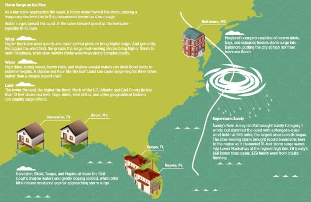
One Year After Sandy, Many Coastlines Are Still Vulnerable To Storm Surges (Infographic). Huffington Post
has an effective explainer and infographic focused on storm surge risk.
Intensity (and diameter) of the storm, coupled with bathymetric data,
the slope of the land just offshore, is a better predictor of storm
surge height than hurricane wind speed (or category). Here's an excerpt:
"
Are Baltimore and Biloxi the next New York City and Jersey Shore? Maybe. A new report from Risk Management Solutions outlines the threats faced by low-lying coastal cities in an age where superstorms may become the new normal.
The group analyzed 100-year surge loss for 12 different coastal cities
and found that Baltimore, Md. and Biloxi, Miss. were among the most
vulnerable cities should another Sandy-like
storm strike the U.S., while Miami, Fla. and North Carolina's Outer
Banks were actually in a low-risk region, contrary to popular belief..."
Five Things Hurricane Sandy Changed For Good. Here's an excerpt of a good summary from
LiveScience:
2. Barrier islands shift
Barrier
islands are the long, thin offshore islands that help protect the
mainland from a powerful beating by storms. Superstorm Sandy pummeled
barrier islands in New York and New Jersey. New York's Fire Island lost more than half of its beach and dune sand.
In Mantoloking, N.J. (a borough of Ocean County, N.J.), almost the
entire dune vanished from the borough's barrier island. Waves also
breached, or cut through, islands in both states.
3. Flood evacuation zones
Drowning
poses the highest risk of death during hurricanes. New evacuation zones
in New York City and new storm-surge maps for the Atlantic and Gulf
coasts will help save lives in the next storm..."
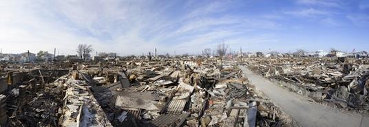
Photo credit above: "
This image shows Hurricane Sandy degris and parts of destroyed houses in Breezy Point on Nov. 12, 2012 in Queens, N.Y." Credit: MISHELLA, Shutterstock.com.
 Hurricane Sandy's Toll On Health
.
Beyond the damage and dislocation, residents of the East Coast in the
path of Sandy are still dealing with some of the emotional tolls of this
unprecedented storm. Here's an excerpt from
CBS News: "...
Although
some 70 million people, across eight nations, were in the path of the
storm, their experiences were very different depending on where they
lived, said James Shultz, director of the Center for Disaster &
Extreme Event Preparedness (DEEP Center) at the University of Miami
School of Medicine. "It wasn't a one-size-fits-all storm; it was a very,
very complex set of exposures," Shultz said. However, a
Gallup-Healthways poll conducted in January this year provides some idea
of the storm's mental-health impact. The poll found that among adults
living in the most affected ZIP codes in New York, New Jersey and
Connecticut, there was a 25 percent increase in diagnoses of depression in the six weeks following the storm. That translates to about 540,000 new diagnoses of depression..."
File photo credit: Alex Brandon, Associated Press.
Over A Trillions Dollars Of U.S. Property At Risk From Storm Surge Flooding? CoreLogic has an
exhaustive look at the risk of storm surge flooding from tropical systems. Here's an excerpt of that 44 page (PDF) report: "
Based
on the 2013 storm surge analysis, the total value of all residential
structures in the U.S. that are exposed to damage from hurricane-driven
storm surge has reached more than $1.1 trillion. It's important to note
that the methadology used for this year's report features enhanced
valuation data, which provides greater accuracy. The damage estimation,
which takes into consideration worst-case scenario conditions,
represents the total value of all homes susceptible to a maximum surge
event, and is not meant to suggest that all properties would be affected
as a result of one single storm or that the full value of all
properties would be lost to storm-surge destruction. There is no
likelihood that a single storm, or even a single storm season, would
damage or destroy every home in the U.S. located in a designated risk
zone..."
Rising Sea Level And Coastal Risk.
Of all the potential impacts of a slowly warming atmosphere (and ocean)
the one that may ultimately impact the most Americans is rising sea
level. As water warms it expands and rises, and storms superimposed on
those rising seas will trigger more coastal flooding in the years to
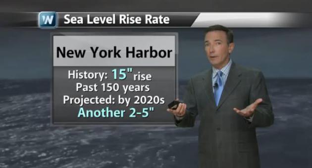
come. Sandy was just a shot across the bow. In today's 2:30
Climate Matters segment I take a look at the CoreLogic findings and talk about natural ways to combat rising seas: "
In
the wake of Superstorm Sandy, WeatherNation Chief Meteorologist looks
at projected sea level rise over the next century and who is most at
risk for storm surge."
China's Clean Air Drive Likely To Take A Long Time.
The New York Times has the story - here's a clip: "...
But
China’s pollution, while extremely severe, is not unique, and efforts
by other countries, like Britain and the United States, to conquer dirty
air may hold lessons for China’s future. The Chinese government is
working on the problem and recently announced new limits on pollutants
along with a promise of increased monitoring. Public awareness has
spiked, a necessary step toward ending the crisis. But the overriding
message from other nations is a discouraging one: Serious change can
take decades, especially when pollution is a byproduct of economic
growth. The classic example is London. Persistent pollution problems
caused by industrialization culminated in a 1952 disaster known as the
Great Smog..."
Photo credit above: "
A Chinese man
covers his nose and mouth as he walks on the street during a day of
heavy pollution in Harbin in northeast China's Heilongjiang province
Monday Oct. 21, 2013. Visibility shrank to less than half a football
field and small-particle pollution soared to a record 40 times higher
than an international safety standard in the northern Chinese city as
the region entered its high-smog season." (AP Photo).
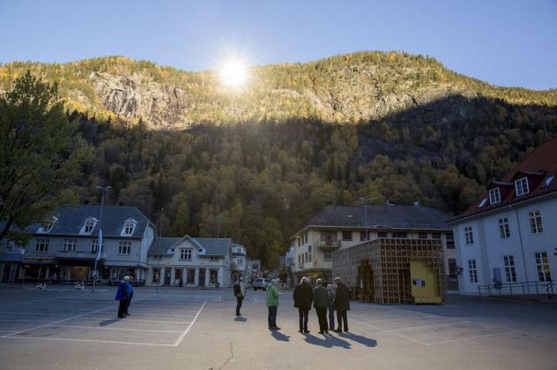
Let There Be Light! Thanks To Large Mirrors, Winter Sun Finally Shines On Norwegian Town. And I thought I was sun-starved. The solution: giant mirrors? Huh. Here's an excerpt of a story from AP and
The Star Tribune: "
Residents
of the small Norwegian town of Rjukan have finally seen the light.
Tucked in between steep mountains, the town is normally shrouded in
shadow for almost six months a year, with residents having to catch a
cable car to the top of a nearby precipice to get a fix of midday
vitamin D. But on Wednesday faint rays from the winter sun for the first
time reached the town's market square, thanks to three 183-square-foot
(17-square-meter) mirrors placed on a mountain. Cheering families, some
on sun loungers, drinking cocktails and waving Norwegian flags, donned
shades as the sun crept from behind a cloud to hit the mirrors and
reflect down onto the faces of delighted children below..."
Photo credit above: "People gather on a spot in front of the town hall of Rjukan, Norway." Tore Meek, Associated Press.
StarChase Tech Lets Police Shoot Fugitive Cars With GPS Tags. Now here's an interesting idea - I'd love to have this for the aggressive drivers who cut me off on 494.
Gizmag.com has the details: "
Police
car chases are extremely dangerous, not only for the officers involved,
but also for any innocent passers-by whom the feeing car crashes into.
The StarChase system, however, is designed to make those chases safer.
Instead of pursuing fugitive vehicles, police can just shoot them with
GPS tags. At the heart of the system is a compressed-air cannon and a
laser sighting system, installed in the front grille of a police car..."
For A Longer Life You Might Try Mowing The Lawn. No time soon, mind you, or your neighbors will stare. Here's a clip from
NPR: "
We
all know we're supposed to exercise daily, but precious few of us do.
And it only seems to get harder with age. There's a reason to try
harder, though. Tacking more years of good health on to your life may be
as simple as mowing the lawn more often and engaging in other everyday
physical activities. Researchers in Sweden measured the health of almost
4,000 60-year-olds in the late 1990s. A dozen years later, they checked
back in. The people who had been active but not "exercising" at age 60
had a 27 percent lower risk of heart attack and stroke over that time,
and a 30 percent lower risk of death..."
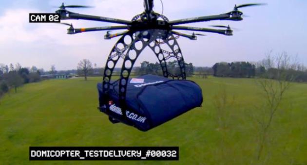
Drones Delivering Pizza? Venture Capitalists Wager On It.
The military (accidently) brought us everything from GPS to the
Internet, why not have a Fed Ex drone drop a package on your front
doorstep? Here's a clip from
Bloomberg: "
Commercial
drones will soon be populating U.S. airspace, and venture capitalists
like Tim Draper are placing their bets. Draper, an early investor in
Hotmail, Skype and Baidu Inc., is now backing DroneDeploy,
a startup that’s building software to direct unmanned aircraft on land
mapping and the surveillance of agricultural fields. Draper even expects
drones to one day bring him dinner. “Drones hold the promise of
companies anticipating our every need and delivering without human
involvement,” Draper, 55, wrote in an e-mail. “Everything from pizza
delivery to personal shopping can be handled by drones...” (Image credit above:
CNN).
Now, A Kiss Isn't Just A Kiss. It's waaay too early in the day for this, but here goes, a clip from
The New York Times: "...
That
may be because for these individuals, kissing turns out to be a quick,
easy way to sample a partner’s suitability — a subconscious stop-go
light. For them, “The Shoop Shoop Song (It’s in His Kiss)”
might not be far off the mark. After that first kiss, these types are
much more likely than other subjects to change their minds about a
potential partner, researchers found. If it’s not in his kiss, forget
about him..."
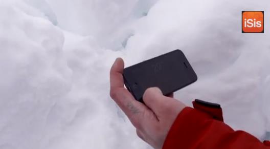
There's Not An App For That: CAC Issues Warning About Avalanche Apps. Wait, you're telling me all those avalanche apps I downloaded don't work properly? Uh oh. Here's a clip from
Gizmag: "...
The
Canadian Avalanche Centre says that avalanche rescue apps can not
effectively replace dedicated avalanche beacons. Some people may be
tempted to save a couple hundred dollars on an avalanche beacon and opt
for one of several apps on the market. The Canadian Avalanche Centre
does not recommend using these apps for actual avalanche incidents,
however. It assessed three European apps – iSis Intelligent (Mountain)
Rescue System, Snøg Avalanche Buddy and SnoWhere – before coming to the
conclusion that they are unreliable and promote a false sense of
security..."
HALLOWEEN: Early shower, then cloudy & dry. Winds: NW 10. High: 49. Trick or Treat temperatures from 45-47F.
THURSDAY NIGHT: Patchy clouds, Zombie Alert still in effect. Low: 40
FRIDAY: Mostly cloudy and cooler. High: 45
SATURDAY: Partly sunny and quiet. Wake-up: 35. High: 46
SUNDAY: Plenty of sun, windy and milder. Wake-up: 32. High: 51
MONDAY: Rain developing PM hours. Wake-up: 46. High: near 50
TUESDAY: Cold rain likely. Wake-up: 41. High: 48
WEDNESDAY: Rain tapers to showers. Wake-up: 38. High: 43
Climate Stories....
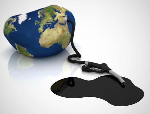
Climate Change May Curb Profits From Fossil Fuels, Study Says. Here's an excerpt of a story at
Bloomberg: "
Fossil-fuel assets such as coal mines and gas wells may lose value if climate change prompts tougher regulations, according to a report from Al Gore
and David Blood’s Generation Investment Management. About two-thirds of
the fossil fuels still underground must remain there if the planet is
to meet a United Nations target of limiting global warming to 2 degrees
Celsius (3.6 degrees Fahrenheit). That means assets such as coal mines
and gas wells may have to reduce production, cutting profits, according
to the paper. “It is no longer prudent for investors and asset owners to
treat climate change as a peripheral issue,” Blood, co-founder of
Generation Investment, said in the statement. “Investors and asset
owners should capitalize on the opportunities emerging from the
transition to a low-carbon economy. The competitive landscape for fossil
fuel-intensive companies is losing its attractiveness at an accelerated
rate...”
Climate Change Risk To One-Third Of Global GDP.
CNBC has the article; here's the introduction: "
Around
one-third of the world's economy by 2025 will be based in countries at
"high" or "extreme" risk from the economic impact of climate change,
according to risk consultancy Maplecroft.
(Read more: The climate change wake-up call for business?)
Thirty-one
percent or $44 trillion of output will be based in countries classified
as most at risk from climate change in Maplecroft's Climate Change
Vulnerability Index, which considered a nation's exposure to extreme
weather events over the next 30 years alongside its capacity to cope
with the impact..."
Image above: Clean Technica.

Report: Climate Change May Pose Threat To Economic Growth.
The key drivers will be not only sea level rise threatening coastal
regions, but warmer temperatures + more evaporation stressing existing
water supplies, impacting agriculture - along with more extreme storms
impacting infrastructure.
CNN has the story; here's the intro: "
Nearly
a third of the world's economic output will come from countries facing
"high" to "extreme" risks from the impacts of climate change within 12
years, according to a new report. The Climate Change Vulnerability Index,
an annual report produced by UK-based risk analysis firm Maplecroft,
found that climate change "may pose a serious obstacle to sustainable
economic growth in the world's most commercially important cities." The
index ranked the vulnerability of the world's countries, and the 50
cities deemed most economically important, to the impacts of climate
change, by evaluating their risk of exposure to extreme climate events,
the sensitivity of their populations to that exposure and the adaptive
capacity of governments to respond to the challenge..."
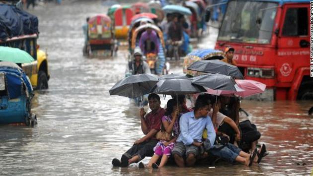
Photo credit above: "Most at risk: Bangladesh: Bangladeshis
attempt to stay dry above flood waters in the capital, Dhaka.
Bangladesh was ranked the country most vulnerable to climate change, and
Dhaka the world's most vulnerable city, due to its exposure to threats
such as flooding, storm surge, cyclones and landslides, its susceptible
population and weak institutional capacity to address the problem."
How You Pay Farmers To Watch Their Crop Shrivel Up And Die.
Mother Jones
takes a look at the increasingly difficult task of coaxing a bumper
crop out of the Earth, as heat and moisture becomes even more
unpredictable: "...
Interviews with more than a dozen climatologists,
agronomists, agro-economists, and agricultural statisticians have
generally echoed the USDA's prognosis: after about 30 years, greenhouse
gas concentrations will reach critical enough levels to significantly
disrupt agriculture. But even the next ten years will probably prove
challenging for American farmers, because the weather will be more
variable. As Columbia University associate professor of international
and public affairs Wolfram Schlenker put it, "there's more certainty
that there will be less certainty." In any case, taxpapyers are on the
hook for climate-related disruption of US food production—mainly in
annual outlays for crop insurance..."
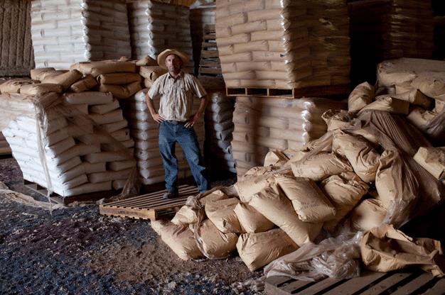
Photo credit above: "
Eric Herm, 36, unloads non-genetically-modified cotton seed into a storage barn on his 6,700 acre farm in West Texas." Photograph: Ben Depp.
The Coming Carbon Asset Bubble. Here's an excerpt of an Op-Ed from Al Gore and David Blood at The Wall Street Journal: "...Delaying
action to mitigate climate change will not delay climate change itself.
As such, investors can strand fossil-fuel energy assets today, or
absorb the cost of inaction by causing a much larger stranding across
industries and asset classes in the future. The case to incorporate
carbon risk into both equity and debt valuations now is one of short-
and long-term prudent risk management. There are four principal ways
investors can do this: First, identify carbon asset risks across
portfolios. At a minimum, investors should determine the extent to which
carbon risk is embedded in current and future investments. This can be
achieved by, for example, considering the key drivers of a company's
current and future asset base in the context of carbon risks and
developing tools that quantify risks for valuations. Note that passive,
index tracking funds should also identify their exposure to carbon risks
since they too are vulnerable to stranding as fossil fuel-dependent
assets make up roughly 10%-30% of most major exchanges..."
 Fossil Fuels Divestment Campaign Is Gathering Momentum
. Bill McKibbon has an Op-Ed at
The Guardian, here's the intro: "
The world has a choice when dealing with climate change.
One is to decide it's a problem like any other, which can be dealt with
slowly and over time. The other is to recognise it as a crisis, perhaps
the unique crisis in human history, which will take rapid, urgent
action to overcome. Science is in the second, scared camp – that's the
meaning of the IPCC report issued last month, which showed that our
planet is already undergoing climatic shifts far greater than any
experienced in human civilisation, with far worse to come. And those of
us urging divestment from fossil fuel stocks are in the second camp too –
we recognise that business as usual is quite simply impossible..."
Rapidly Melting Glaciers Give Utah Expert New View On Climate Change. Reading an article or research study is one thing; seeing the impacts with your own eyes is quite another, as reported by
KSL.com in Salt Lake City; here's the intro: "
ANCHORAGE, Ala. — It's
no secret that glaciers around the world are disappearing. But in
Alaska, the pace of the meltdown is so rapid that a glacier expert who
moved there from Utah says it changed his view of climate change. "I
didn't really believe that climate change was a big enough deal to be a
problem," Evan Burgess said. "But coming up here has really changed my
whole perspective on that." Say what you
will about the causes of climate change; according to Burgess, the
meltdown is for real in Alaska. It's rapid and it's getting faster. Burgess
recently finished his Ph.D. in geography at the University of Utah,
specializing in glaciology. He has also studied glaciers in Greenland;
and earlier this year he moved to Alaska to work for the U.S. Geological
Survey and the University of Alaska Fairbanks..."

Meet The Pacific Rim's New Environmental Superpower. What's happening on the West Coast is interesting; it may prove to be a catalyst for the rest of the nation, as outlined at
Quartz; here's an excerpt: "
In Ernest Callenbach’s 1975 novel Ecotopia,
northern California, Oregon and Washington secede from a US in
financial collapse to form an ecological superpower fueled by renewable
energy and electric cars. Yesterday, California, Oregon and Washington,
along with British Columbia, signed a pact to form an environmental
alliance powered by renewable energy and electric cars. The future is
now. The Pacific Coast Action Plan on Climate and Energy
calls on the states and the Canadian province to set common mandates
for cutting carbon emissions and link their programs for doing so. Among
other things, the governments agreed to adopt low carbon fuel standards
and ensure that 10% of all private and public vehicle purchases are
zero-emission cars by 2016..."

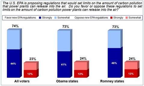
New Poll: Is Attacking The EPA The Bright Idea Tea Partiers Think It Is? Here's an excerpt from
Huffington Post: "...
Attacks
on the EPA are falling flat. Voters trust the EPA, not a Congress with
single-digit approval ratings, to decide whether we need regulations
that will reduce carbon pollution. In fact, the polling in Alaska,
Arkansas, Colorado, Georgia, Iowa, Louisiana, Michigan, Montana, New
Hampshire, North Carolina, and Virginia, showed that nearly three in
every four voters in these swing Senate states support EPA regulations
that would set limits on the amount of carbon pollution from power
plants..."









.jpg)

No comments:
Post a Comment