50 F. high in the Twin Cities Saturday.
53 F. average high on October 26.
39 F. high on October 26, 2012.
October 26 in Minnesota Weather History:
1943:
Said to be one of the worst fogs in the Twin Cities in memory. A very
dense area of fog, with an average of 75 feet in thickness, blanketed
the area. At the worst, street lights could not be seen 25 yards away.
Drivers refused to cross unmarked railroad crossings and traffic was
brought to a standstill.
1931: Storm hits the Duluth area. Barometer falls to 29.02. Data courtesy of the MPX National Weather Service.
"...
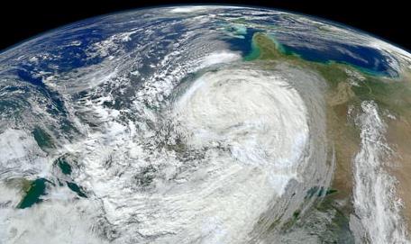
Sandy
roared out of the Atlantic and struck the New York and New Jersey
coasts on Oct. 29, 2012. The 1,000-mile-wide mashup of a hurricane and
another huge weather system killed at least 182 people in the U.S.,
according to a count by The Associated Press, and caused an estimated
$65 billion in damage..." - from an AP/ABC News story below. Image: NASA.
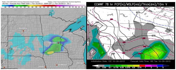
Midday Tuesday. NAM model (upper left) courtesy of Ham Weather; ECMWF model (upper right) courtesy of WSI.
Dueling Models
This
is why I spend much of the day massaging my pet ulcer and plucking at
grey, thinning wisps of hair on top of my aching head.
Weather
models rarely agree. During the winter this numerical dysfunction
becomes even more problematic. Which model has the best track record -
which one do you trust?
NOAA's NAM model brushes southern
Minnesota with a coating or inch of slushy snow Tuesday, while the ECWMF
(European) model takes the brunt of the storm just south of Minnesota.
Although the "Euro" tends to nail hurricanes and coastal storms, the NAM
can't be dismissed.
I'm hedging my bet and mentioning a (slight)
risk of a coating on Tuesday. With surface temperatures above freezing
most roads would probably remain wet, but snow may accumulate on lawns,
fields and slow-moving neighbors, mainly south of the MSP metro area.
Check the weather blog for updates.
A second, more significant
surge of southern moisture arrives Wednesday, when the atmosphere should
be warm enough for all-rain. The good news: the back edge of the rain
may be just east of town in time for a gray, damp, mostly-dry Halloween.
The
Werewolf Watch remains in effect. Let's see if a Snow Advisory is
issued for Tuesday, but right now I don't think it's going to be a big
deal.
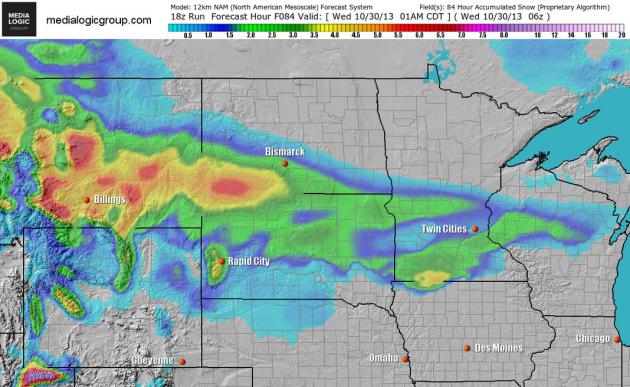
NAM: Slush Potential.
Not buying it (yet), but the 12km NAM simulation shows a burst of wet
snow, or a rain-snow mix, pushing across southern Minnesota Tuesday,
with an inch or two of slush on lawns and fields. Although the ECMWF
guidance shows most of the moisture sliding south of Minnesota we can't
rule out a few hours of wet snow on Tuesday. Map: NOAA and Ham Weather.
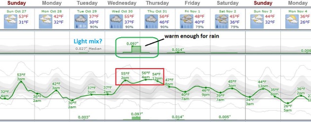
ECMWF: No Big Deal.
We will see which model emerges victorious, but the European looks
thoroughly unimpressive, a very light period of snow on Tuesday, maybe a
coating. By Wednesday, when the main surge of Gulf moisture arrives,
the atmosphere should be warm enough for all-rain as highs push into the
50s. The bulk of the rain is forecast to push east of Minnesota on
Halloween. Graphic: Weatherspark.
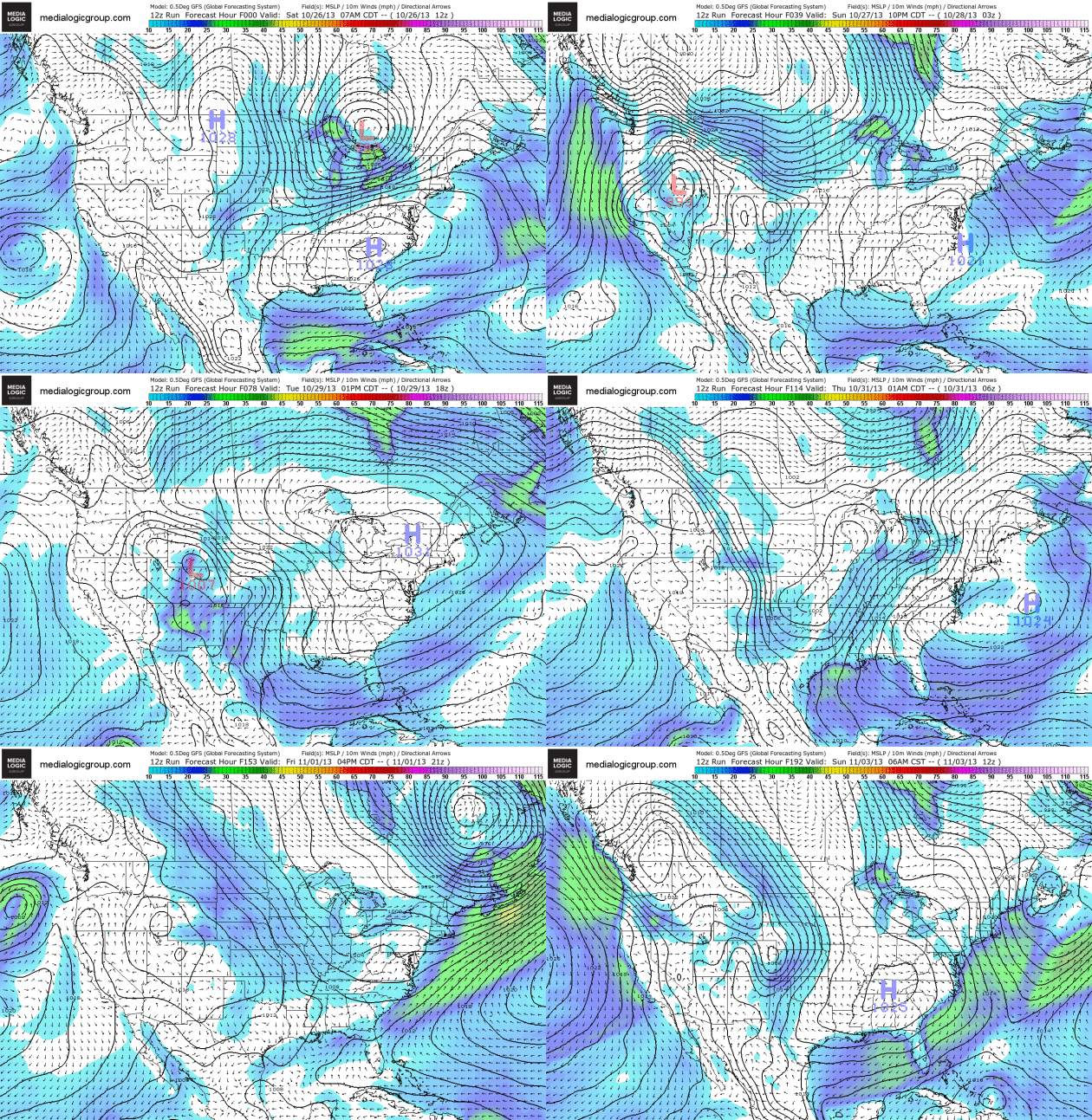
Soggy Halloween For Midwest, Great Lakes.
Pint-size ghosts, goblins and zombies may need to waterproof their
costumes on Thursday. GFS guidance shows a significant storm spinning up
over Nevada, pushing across the Plains into the Great Lakes by
Thursday, spreading rain into Des Moines, the Twin Cities, Chicago and
Detroit. The East Coast remains dry until Friday, a storm pushing into
the Pacific Northwest by the end of the week. GFS guidance above shows
forecast pressure and 10 meter wind speeds, courtesy of NOAA and Ham
Weather.
Atlantic Hurricane Season Quietest In 45 Years, Experts Say.
Reuters has a good recap of the Atlantic hurricane-season-that-wasn't; here's an excerpt: "
The
2013 Atlantic hurricane season looks set to go down as a big washout,
marking the first time in 45 years that the strongest storm to form was
just a minor Category 1 hurricane.
There could still be a late surprise in the June 1-November 30 season,
since the cyclone that mushroomed into Superstorm Sandy was just revving
up at this time last year. But
so far, at least, it has been one of the weakest seasons since modern
record-keeping began about half a century ago, U.S. weather experts say..."
 12 Strange Weather Features Of Superstorm Sandy
. Yes, Sandy set a number of "firsts". AP has an eye-opening list, reported at
The Fresno Bee; here's a clip:
3.
SNOW: This is the first time the National Hurricane Center ever listed
snow or blizzard in their warnings. Three feet of snow fell in West
Virginia.
4. GREAT LAKES: It is unusual for 20 foot
waves, large surges and tropical force winds to be recorded in the Great
Lakes for a coastal tropical storm, but it happened with Sandy.
5.
ENERGY: NOAA's Hurricane Research Division has an experiment program
that measures integrated energy of a storm's surge and waves on a 0 to
6.0 scale. Sandy reached 5.8, passing Katrina as the highest recorded so
far...
Image credit: "
This
Tuesday, Oct. 30, 2012 NOAA satellite image at 10:45 a.m. EDT shows
Superstorm Sandy moving westward while weakening across southern
Pennsylvania. With tropical storm force winds that extended for 1,000
miles, Sandy was the largest Atlantic system on record." NOAA — AP Photo.
Read more here: http://www.fresnobee.com/2013/10/25/3568241/12-strange-weather-features-of.html#storylink=cpy
Read more here: http://www.fresnobee.com/2013/10/25/3568241/12-strange-weather-features-of.html#storylink=cpy
A Year After Sandy, A Slow Recovery For Thousands. Here's an excerpt of a good overview from AP and
ABC News: "
A
year after Superstorm Sandy catastrophically flooded hundreds of miles
of eastern U.S. coastline, thousands of people still trying to fix their
soaked and surf-battered homes are being stymied by bureaucracy,
insurance disputes and uncertainty over whether they can even afford to
rebuild. Billions of dollars in federal aid appropriated months ago by
Congress have yet to reach homeowners who need that money to move on.
Many have found flood insurance checks weren't nearly enough to cover
the damage. And worse, new federal rules mean many in high-risk flood
zones may have to either jack their houses up on stilts or pilings — an
expensive, sometimes impossible task — or face new insurance rates that
hit $10,000 or more per year..."
Editorial: Keep The Sense Of Sandy Urgency. A hurricane year like the one we just had can breed complacency. Long Island's
Newsday
reminds us that storms similar in scope to Sandy are inevitable in this
editorial; here's a clip: "...Many still are caught in the storm's
aftermath. Houses still are being demolished and repaired. Hundreds of
exiled families have yet to return. Some businesses have yet to reopen.
Our power company has a new structure with more accountability and big
plans but still is vulnerable. Sandy taught us a lot. It taught us that a
house near the water or with a view of it might not be an ever
appreciating investment. It taught us that a damaged house or one with
no power could put a family in crisis. It taught us that we were not
prepared..."
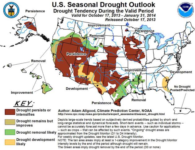
Drought Could Worsen In Major Crop Area.
AgWeb has the story; here's the introduction: "
Despite
widespread, harvest-slowing rains over a wide swath of the Upper
Midwest in October, the long-term drought is expected to persist or
intensify across much of Iowa, western Illinois, and northern Missouri,
according to the U.S. Seasonal Drought Outlook,
a joint publication of the National Drought Mitigation Center at the
University of Nebraska-Lincoln, the National Oceanic and Atmospheric
Administration, and USDA. Drought is also expected to persist or develop
across the Southwest, western California, and parts of the western Corn
Belt, including the western half of both Nebraska and Kansas, according
to the outlook, released Oct. 17..."
Redefining The Meaning Of A "500 Year Flood". Two historic floods in the span of 5 years? The
NewsTribune
explains why many residents living along the Illinois River are groping
for better ways to explain the extremes of recent years; here's a clip:
"...
Don't use the term "500-year flood" in front of people in
Utica. The Illinois River has overflowed twice in five years and
residents think scientists need a better term to chart the occurrence of
floods. But ask two-time survivors about bouncing back from the April
flood and most will acknowledge that experience has been a good teacher...."
Flood Insurance Surge Socks Residents.
New York and New Jersey residents are still suffering through a
hangover from Superstorm Sandy, which struck with an otherworldly fury
on October 29, 2012. Reality is setting in, the form of radically higher
flood insurance premiums, as the
New York Post explains. Here's an excerpt: "
Hurricane
Sandy is about to sock unwary homeowners again. A report commissioned
by the city has found that 35 percent of the 68,000 buildings required
to carry flood insurance in newly expanded federal flood zones don’t
have it. The cost of that insurance could be astronomical — $5,000 to
$10,000 a year. The premiums had been averaging $429 a year. Those
shopping for new insurance will have to pay the full freight immediately..."
Photo credit above: "
Christine Cina and her dog amid what is left of her house on Staten Island, a year after Sandy blew through." Photo: Reuters.
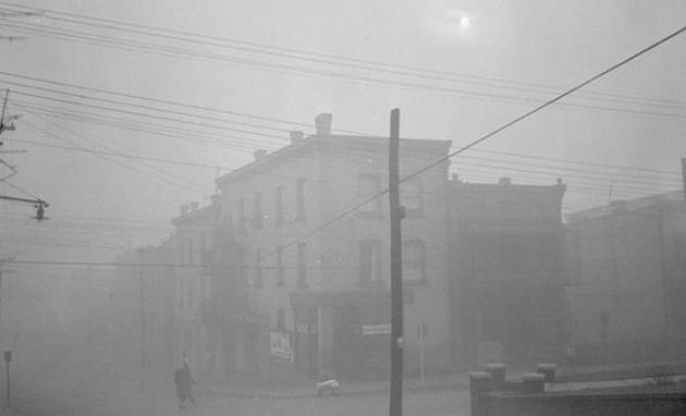
U.S. Once Had Air Pollution To Match China's Today. Jack Williams provides some timely perspective in this story at The Washington Post's
Capital Weather Gang. Here's an excerpt: "
During the 1940s and 1950s some parts of the United States experienced pollution episodes like those now occurring across parts of China. And even on good days the air wasn’t as clean as it generally is now.
Related: Chinese city shut down by off-the-charts pollution
One
of the worst of these episodes, and one that helped focus attention on
U.S. air pollution, was the choking, deadly smog that covered Donora,
Pa., in the Monongahela River Valley, 20 miles southeast of Pittsburgh
from Oct. 27 to 31, 1948..."
Photo credit above: "
On
Oct. 30, 1948, Donora’s main business district was cloaked in smog, the
sunlight virtually obliterated by thick low-hanging pollution." (Associated Press).
TODAY: Partly sunny. More hints of Indian Summer. Winds: W/SE 10-20. High: 57
SUNDAY NIGHT: Partly cloudy, turning colder. Low: 31
MONDAY: Patchy clouds, cooler again. High: 43
TUESDAY: Mostly cloudy, chance of a light mix. Slushy coating south? High: 39
WEDNESDAY: Warm enough for rain, steady and heavy at times. Wake-up: 35. High: near 54
HALLOWEEN: Wet start. Partial clearing by afternoon. Probably dry for Trick or Treating. Wake-up: 45. High: 53
FRIDAY: Mostly cloudy, windy & cooler. Wake-up: 37. High: 47
SATURDAY: Mostly cloudy and brisk. Wake-up: 33. High: 44
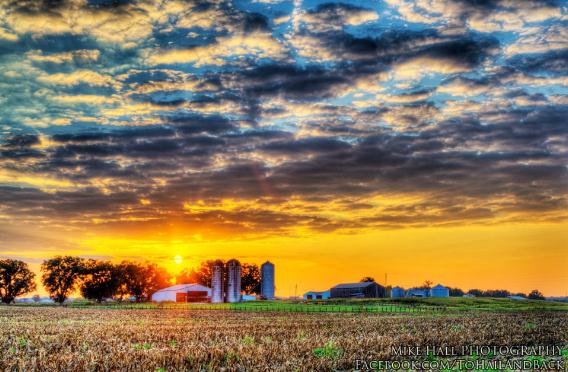
* photo credit above: Mike Hall.
Climate Stories...

Acidification Of Oceans Threatens To Change Entire Marine Ecosystem. The Vancouver Sun has the article; here's the intro: "
Ocean
acidification due to excessive release of carbon dioxide into the
atmosphere is threatening to produce large-scale changes to the marine
ecosystem affecting all levels of the food chain, a University of B.C.
marine biologist warned Friday. Chris Harley, associate professor in the
department of zoology, warned that ocean acidification also carries
serious financial implications by making it more difficult for species
such as oysters, clams, and sea urchins to build shells and skeletons
from calcium carbonate. Acidic water is expected to result in thinner,
slower-growing shells, and reduced abundance. Larvae can be especially
vulnerable to acidity. “The aquaculture industry is deeply concerned,”
Harley said. “They are trying to find out, basically, how they can avoid
going out of business...”
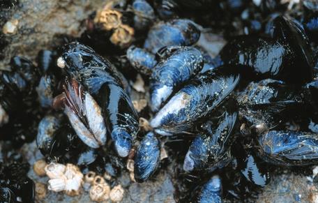
Photo credit above: "
Ocean
acidification due to excessive release of carbon dioxide into the
atmosphere is threatening to produce large-scale changes to the marine
ecosystem affecting all levels of the food chain, a University of B.C.
marine biologist warned Friday." Photograph by: Nick Didlick , VANCOUVER SUN.
Arctic Temperatures Reach Highest Levels In 44,000 Years, Study Finds. Here's the intro to a LiveScience story at
Huffington Post: "
Plenty
of studies have shown that the Arctic is warming and that the ice caps
are melting, but how does it compare to the past, and how serious is it?
New research shows that average summer temperatures in the Canadian Arctic
over the last century are the highest in the last 44,000 years, and
perhaps the highest in 120,000 years. "The key piece here is just how
unprecedented the warming of Arctic Canada is," Gifford Miller, a
researcher at the University of Colorado, Boulder, said in a joint
statement from the school and the publisher of the journal Geophysical
Researcher Letters, in which the study by Miller and his colleagues was
published online this week..."
Climate Change Will Make Colorado's Millenial Rainstorm A Lot More Common. Here's an update from
Quartz: "
The rainfall that caused massive flooding in Colorado last month was a once-in-a-millennium event, according to a recent study (pdf). And climate change is making those kinds of extreme weather events more common. The
impressively named Hydrometeorological Design Studies Center, a
division of the National Weather Service, has concluded with greater
than 90% certainty that the rainfall was millennial in nature. Here’s
the chart for one rain gauge in Boulder, Colorado, that was inundated
over seven days.."
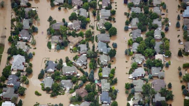
Photo credit above: "Houses partially submerged last month in Longmont, Colorado." AP/John Wark
Elon Musk: Oil Campaign Against Electric Cars Is Like Big Tobacco Lobbying.
The Guardian has the story - here's an excerpt: "
Attacks
on electric cars by the oil industry are on a par with misinformation
campaigns promoted by big tobacco companies and vested interests
undermining climate science, according to Elon Musk, the serial entrepreneur who founded PayPal and the brains behind both the space exploration company SpaceX and the electric sports carmaker Tesla Motors.
The oil giants, he reckons, are attempting to sow the seeds of doubt.
Speaking before the opening of Tesla's new luxury store in the Westfield
shopping mall in Shepherd's Bush, London, last night, Musk told the
Guardian: "It's kinda like the battle against 'big tobacco' in the old
days, and how they'd run all these ads about how tobacco's no problem..."
Photo credit above: "
Elon Musk in the new Tesla Model S high performance electric car in the showroom at Westfield London." Photograph: Sarah Lee for the Guardian.
Bad Climate Science In U.S. Schools: An Open Letter To Heartland and NIPCC. Those serial-misinformers and perpetual truth-twisters at
The Heartland Institute
are at it again. Now they're going after teachers, trying to convince
them that climate science isn't "settled", that "there are two sides to
this important story". Right. Here's a clip of an open letter to
Heartland and "NIPCC" at
Small Epiphanies:
Open Letter — October 2013
To: Diane Carol Bast, Executive Editor, The Heartland Institute
Re: Release of Climate Change Reconsidered II: Physical Science
Dear Mrs. Bast,
Thanks for sending out your helpful, if somewhat self-congratulatory,
memo to so many US teachers (PDF).
Its subject is important: the NIPCC’s gripping sequel “Climate Change
Reconsidered II”, a title as original as the ‘Not the IPCC’ nomenclature
is witty.
While I’m sure nobody would question your
organisation’s motive in wanting to reach out to so many young and
impressionable minds (and I’m sure very few will conflate this
initiative with
Heartland’s sturdy defence of the embattled tobacco industry during the 1990s) there are some minor issues that might demand attention....
Adversaries, Zombies And "NIPCC" Climate Psuedoscience. There's a lot of (manufactured/sponsored) misinformation out there, as described in this post at Australia's
The Conversation; here's a clip: "...
IPCC
reports openly discuss the strengths, weaknesses, criticisms and
uncertainties of the science. The reports provide policy makers with a
range of plausible outcomes given rising atmospheric CO2. Heartland’s
NIPCC partially mimics the IPCC, but with key differences. It is written
and reviewed by dozens of people, almost exclusively drawn from the “sceptic” community,
and is consequently highly partisan. Indeed, the NIPCC advocates an
adversarial approach to assessing climate science, with partisan “teams”
arguing for different positions..."
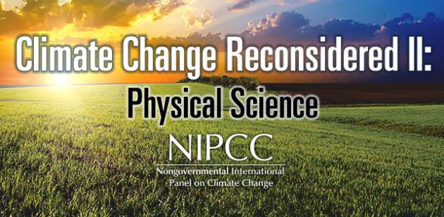
Photo credit above: "
Dead science lives on, thanks to the Non-governmental International Panel on Climate Change."
Scott Beale.


.jpg)






No comments:
Post a Comment