49 F. average high on November 3.
43 F. high on November 3, 2012.
November 3 in Minnesota Weather History - courtesy of the Twin Cities National Weather Service:
1982: 20 inches of snow falls in the Kabatogema area.
1901: With a high temperature of only 22 and a low of 15, 175 boxcars of potatoes were in peril at the Minneapolis rail yard. Workers scrambled to move the rail cars full of tubers in roundhouses and transfer potatoes to refrigerated cars. Individual stoves had to be purchased on the spot for 59 remaining cars. Thankfully, most of the spuds were saved.
1853: Cold snap begins at Ft. Snelling. The next four days would be 16 degrees or lower.
1727: The first outdoor celebration at the chapel of Fort Beauharnois on Lake Pepin was postponed due to "variableness of the weather."

What Did You Eat?
My niece, Anna Ball, just got back from an extended stay in Italy. She told me locals don't greet each other with "How are you?" They ask "What did you eat?" Life revolves around food. Can't remember?
"If you can't remember what you ate it must not have been very good" Anna told me.
I'm lobbying St. Paul to replace "What do you think of this weather?" OK, don't hold your breath.
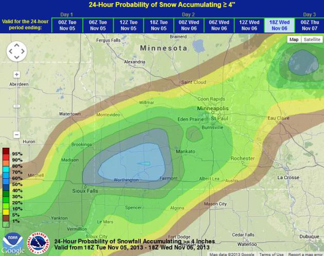
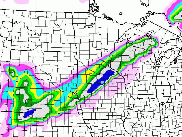
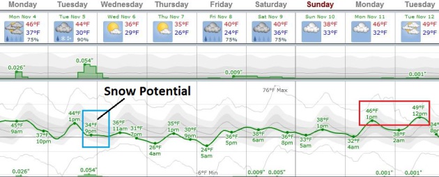
What may be our first accumulating snow event of the winter season may materialize from a sloppy southern storm; a cold rain Tuesday afternoon changing to wet snow Tuesday night.
Ground temperatures are still fairly mild, so I expect some melting on contact, but a few inches could pile up on metro lawns; roads becoming slushy and slick after 7 PM. The ECMWF (European) model prints out 6+ inches for southwest counties.
And so it begins.
This is just Old Man Winter firing a warning shot across our bow. After a couple days in the 30s midweek we thaw into the 40s; I could see a few days above 50F next week. No sign of anything frigid just yet.
A puff of cooler air sparks a few rain showers today. Within 36 hours there will be no doubt in your mind that it's November.
What DID I eat? I'd rather focus on food.
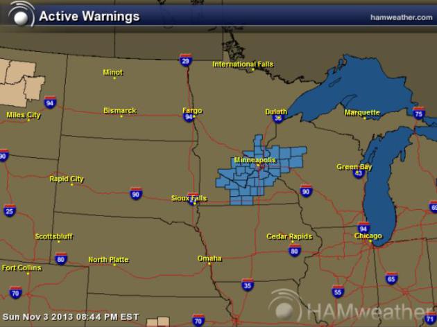
Winter Storm Watch Posted. Map courtesy of Ham Weather. The Twin Cities office of the NWS has issued a Winter Storm Watch, which means a potential for "plowable" amounts of snow, coming Tuesday night. Details:
...WINTER STORM WATCH IN EFFECT FROM TUESDAY AFTERNOON THROUGH
LATE TUESDAY NIGHT...

THE NATIONAL WEATHER SERVICE IN TWIN CITIES/CHANHASSEN HAS ISSUED
A WINTER STORM WATCH...WHICH IS IN EFFECT FROM TUESDAY AFTERNOON
THROUGH LATE TUESDAY NIGHT.

* SNOW ACCUMULATION: 4 TO 7 INCHES...WITH HIGHER AMOUNTS POSSIBLE.

* TIMING: RAIN WILL OVERSPREAD THE AREA FROM THE SOUTH TUESDAY
  AFTERNOON WITH A TRANSITION TO SNOW OCCURRING LATE TUESDAY
  AFTERNOON OR EVENING. THE SNOW WILL TAPER OFF LATE TUESDAY NIGHT
  OR EARLY WEDNESDAY MORNING.

* IMPACTS: THE FIRST HEAVY SNOW OF THE SEASON IS POSSIBLE NEAR THE
  TUESDAY AFTERNOON AND WEDNESDAY MORNING COMMUTES. IN
  ADDITION...IT IS LIKELY TO BE A WET SNOW AND ANY TREES WITH
  LEAVES LEFT ON THEM MAY BE STRESSED...LEADING TO BROKEN TREE
  LIMBS AND ISOLATED POWER OUTAGES.

Winter Hazard Awareness Week In Minnesota. Map above shows average annual snowfall for Minnesota, courtesy of the Twin Cities NWS. Here's an excerpt of some good (timely?) information from the local National Weather Service office: "During Winter Hazard Awareness Week the National Weather Service, in cooperation with the Department of Homeland Security and Emergency Management will issue daily statements pertaining to winter safety. These statements are available below, and will also be broadcast over NOAA All Hazards Weather Radio and sent over the NOAA Weather Wire."
In summary, we offer these basic reminders:
Winter Weather Preparations
- Keep ahead of the winter storm by listening for the latest weather statements, watches and warnings.
- Your vehicle should also be ready. Get it winterized, before the onset of winter weather.
- Be equipped for the worst. Carry a winter survival kit in your car, especially when traveling in rural or open areas. Try to travel with others.
- Yield to snowplows, and give them plenty of room to operate.
- If your vehicle becomes stranded, stay with it until help arrives.
- Do not try to walk for help during a blizzard, you could easily become lost in the whiteout conditions.
- If you will be outside during storms or extreme cold, dress in layered clothing and avoid overexertion.
- Do not kill yourself shoveling snow. Shoveling is very hard work and may induce a heart attack.
- If you will be snowmobiling, avoid alcohol. Most snowmobile deaths are alcohol related. Take a snowmobile course offered by the DNR or check with your snowmobile dealer.
- Every year, there are fatalities in Minnesota when people fall through thin ice.

Snowfall Last Winter. Nearly 68" of snow fell last winter, most of it during the latter half of winter (well into "spring"). The odds of this happening two winters in a row? Slim, but not zero. With any luck we won't be shoveling in May of 2014. Map above courtesy of the Twin Cities National Weather Service.
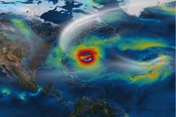
Obama Signs Order On Response To Weather Disasters And Climate Change. Here's a clip from an article at The Washington Post: "A year after Hurricane Sandy devastated the East Coast, President Obama signed an executive order Friday to make it easier for states and local governments to respond to weather disasters. The executive order establishes a task force of state and local officials to advise the administration on how to respond to severe storms, wildfires, droughts and other possible effects of climate change. The task force includes governors of seven states — all Democrats — and the Republican governor of Guam, a U.S. territory. Fourteen mayors and two other local leaders also will serve on the task force. All but three are Democrats..."
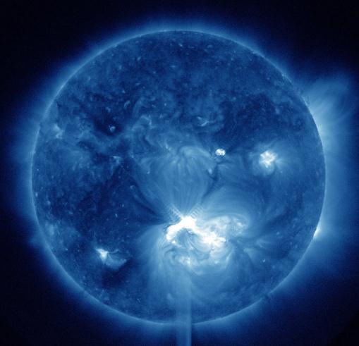
Solar Activity Heads For Lowest Low In Four Centuries. No, it's not the sun heating things up (that's the first thing climate scientists analyzed). Here's an excerpt from New Scientist: "The
sun's activity is in free fall, according to a leading space physicist.
But don't expect a little ice age. "Solar activity is declining very
fast at the moment," Mike Lockwood, professor of space environmental
physics at Reading University, UK, told New Scientist. "We estimate
faster than at any time in the last 9300 years." Lockwood and his
colleagues are reassessing the chances of this decline continuing over
decades to become the first "grand solar minimum" for four centuries.
During a grand minimum the normal 11-year solar cycle is suppressed and
the sun has virtually no sunspots for several decades. This summer should have seen a peak in the number of sunspots, but it didn't happen..." (Image: NASA).
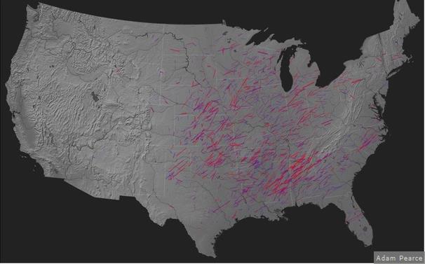
America's Most Violent Tornadoes Since 1950, Seen On One Blustery Map. Here's a clip from a fascinating article at The Atlantic Cities: "...The interactive visualization, available here for your geeking-out pleasure, was assembled by New York City technoartist Adam Pearce, who also did that wonderful presentation of 500 years of meteor spottings. Inspired by a similar model
made by John Nelson, Pearce whipped up a map that gives the track and
wind intensity for each of the twisters. While meteorologists have noted
more than 21,000 tornadoes in the past 63 years, only long-lasting ones
that traveled for more than 20 miles are shown here (just under 2,000).
Fatter lines represent more powerful ones, and the tracks are
approximate, as NOAA "only collects start and end locations – tornadoes
do not actually travel in perfectly straight lines," explains Pearce..."
Graphic credit above: Adam Pearce.
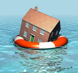
Flood Insurance Is A Complex Problem That May Have A Simple Solution.
Let the markets handle this vs. the federal government? Interesting
idea, but what happens if a massive calamity wipes out a few of these
private ventures? Here's a clip from a story at Insurance News Daily: "...There
is a solution to the federal program’s problems that is beginning to
gain attention, though it is somewhat unconventional. Some federal
lawmakers argue that private insurers are capable of handling the risks
associated with flood insurance coverage. Large insurance corporations
certainly have the assets to offer coverage in an effective manner, but
have little incentive to do so due to the potential of grievous loss. If
the federal government could provide some degree of financial safety
net for these companies, they may be willing to take on the risks
associated with flood coverage, thereby alleviating some of the strain
burdening the National Flood Insurance Program."
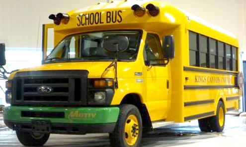
Photo credit above: "The Trans Tech/Motiv SST-e all-electric school bus can save a school district about 16 gallons of fuel a day, or around $11,000, over a year." Photo credit: PRNewsFoto/Motiv Power Systems.
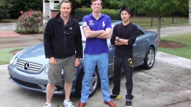
Photo credit above: "Dave Black, Ed Bolian and Dan Huang pose in front of the car they would use to attempt to break the record. Bolian is the leader and main driver, Black acted as the co-driver and Huang was the team's spotter - keeping an eye on the car's considerable technology while looking out for obstacles."
TODAY: Mostly cloudy, few showers. Winds: SW 10-20. HIgh: near 50
MONDAY NIGHT: Partial clearing, turning cooler. Low: 33
TUESDAY: Mostly cloudy with rain developing. High: 45
TUESDAY NIGHT: Rain changes to wet snow, a few inches possible - some roads may become slushy and slick, especially west of MSP. Low: 29
WEDNESDAY: Slow AM commute? Slow clearing. High: 39
THURSDAY: Partly sunny, still chilly. Wake-up: 26. High: 36
FRIDAY: More clouds, few rain showers. Wake-up: 30. High: 43
SATURDAY: Showers taper, few flurries. Wake-up: 33. High: 41
SUNDAY: Blue sky returns, a bit milde.r Wake-up: 29. High: 46
Climate Stories....
"First they ignore you, then they laugh at you, then they fight you, then you win."
- Ghandi
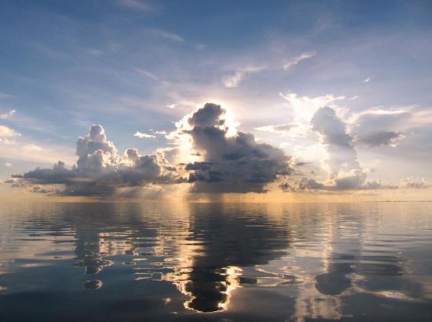
Climate Change Seen Posing Risk To Food Supplies. Here's an excerpt of a Justin Gillis article at The New York Times: "...In
a departure from an earlier assessment, the scientists concluded that
rising temperatures will have some beneficial effects on crops in some
places, but that globally they will make it harder for crops to thrive —
perhaps reducing production over all by as much as 2 percent each
decade for the rest of this century, compared with what it would be
without climate change. And, the scientists say, they are already seeing
the harmful effects in some regions..."
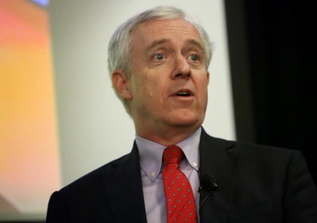
Photo credit above: "Retired Rear Admiral David W. Titley, who led the U.S. Navy's Task Force on Climate Change, delivers the President's Lecture Series speech at ODU on Wednesday, Oct. 30, 2013. Titley, who is director of the Center for Solutions to Weather and Climate Risk at Penn State University, gave a speech titled "The Evolving Understanding of Climate Risk: The Challenge that Won't Go Away." (Steve Earley | The Virginian-Pilot).
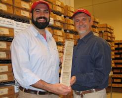
Photo credit above: "Morgan Schaller, James Wright, and the core sample that helped them understand what happened - and how fast it happened - 55 million years ago." Credit: James Wright, Rutgers University.
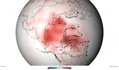
Image credit above: "Departure from average of Arctic surface temperatures during the first decade of the 21st century, as compared to the 1971-2000 average. The map illustrates that no part of the Arctic experienced cooler-than-average conditions during this period." Credit: NOAA.


No comments:
Post a Comment