49 F. high in the Twin Cities Thursday.
65 F. average high on May 1.
56 F. high on May 1, 2013.
.04" rain fell at MSP International Airport yesterday.
9.96" precipitation so far since January 1.
6.33" average precipitation at MSP, to date.
May-bruary
When
weather stalls bad things can happen. That was certainly the case this
week: biggest tornado outbreak of the year so far (EF-4 strength in
Arkansas), biblical 26-inch rains near Pensacola and raging wildfires
outside Los Angeles.
A few take-aways from the latest tornado
swarm. 1). Most of us are drowning in data, but NOAA Weather Radio is
still the most effective way to get life-saving warnings, especially at
night, when tornadoes produce a disproportionate number of deaths. 2).
Research at the University of Alabama suggests that garage doors are
often the weakest link in the chain. Once the garage doors come off the
combination of wind & pressure can tear away at a home's structure.
If you don't have a basement consider skipping a family vacation and
reinforcing a closet to be a "safe room". You may thank yourself down
the road.
A weak clipper sparks a few showers today - but the
weekend looks dry with 50s and a ration of desperately needed sun.
Sunday showers may brush southern Minnesota.
No hot fronts are
imminent but we'll see 60s, even 70F by the middle of next week, with a
few scattered T-storms. April was 5F cooler than average.
Welcome to the (very) reluctant spring of '14.
Easing Back into Spring.
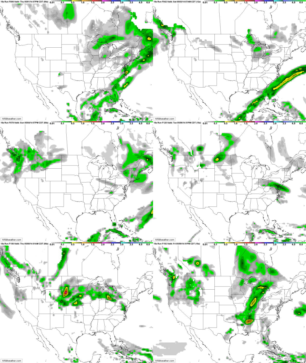
The jet stream lifts north next week, pushing strong to potentially
severe storms into the Upper Midwest by the middle of next week.
California remains dry; heavy showers pushing north across the Pacific
Northwest. GFS Outlook: NOAA and HAMweather.
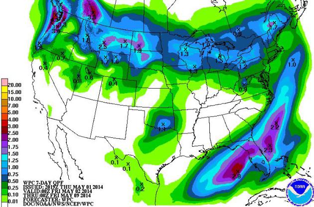
7-Day Rainfall Outlook.
NOAA ensemble models shows some 1-2" rains for parts of Florida
(including hard-hit counties in the Panhandle), and from Seattle to
Bismarck, Madison, Flint and Rochester New York by Friday of next week.
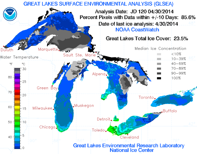
Great Lakes Ice Cover.
There may still be ice on stretches of Lake Superior in early June at
the rate we're going. As of April 30, 2014 23.5% of the Great Lakes were
still covered in ice. Source:
NOAA GLERL.
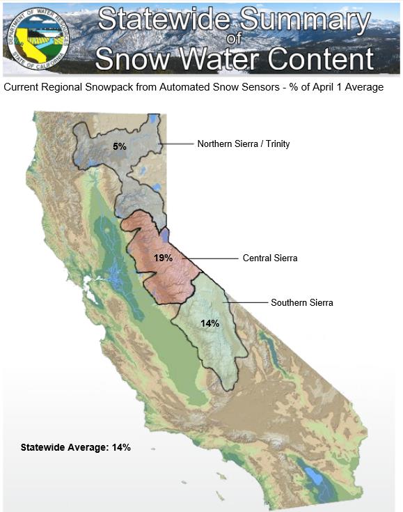
A Discouraging Snowpack Update for California. There won't be much water to replenish low reservoirs in California this year, based on the latest findings from the
California Department of Water Resources; here's an excerpt: "
Anyone
who doesn't think conservation is important should drive up the hill
and take a look," said DWR Director Mark Cowin. "Coupled with half our
normal rainfall and low reservoir storage, our practically nonexistent
snowpack reinforces the message that we need to save every drop we can
just to meet basic needs." More dramatically, today's electronic
readings shows a dismal 7% of average water content in the northern
Sierra snowpack that helps fill the state's major reservoirs which
currently are only half full..." (Image above courtesy of
Pacific Institute).
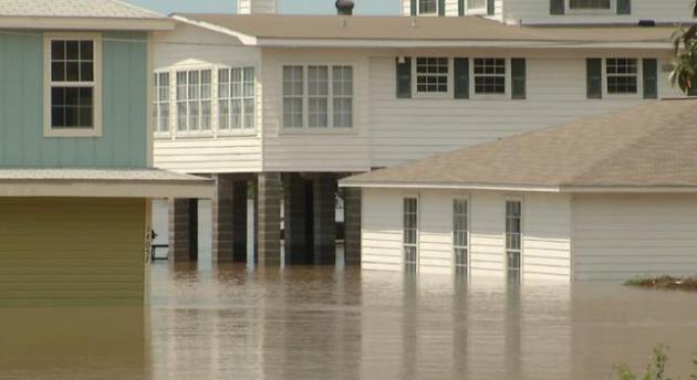
"Worse Than Hurricane Ivan". Hundreds Rescued From Gulf Coast Floodwaters.
Pensacola picked up 15.55" of rain on Tuesday, a new 24-hour rainfall
record. To put that into perspective Los Angeles has seen 15.9" of rain
since January 1, 2012! Here's an excerpt from
nola.com: "...
In
Gulf Shores, Ala., where nearly 21 inches of rain fell over a day's
time, the scene resembled the aftermath of a hurricane. At the Sportsman
Marina in Orange Beach, employee J.J. Andrews couldn't believe what she
saw out the window. "We've got water up in our parking lots," she said.
"Our docks are under water. It's worse than during Hurricane Ivan, is
what they're saying. It's crazy." The 2004 hurricane dumped 3 to 7
inches of rain along the Florida Panhandle..."
Photo credit above: "
In
Foley, Alabama, some people couldn't get out of their homes on
Wednesday, April 30, 2014, after flood waters surrounded their homes,
many of which are built on stilts. The National Weather Service says the
Fish River peaked at a record high level of 23.18 feet after more than
22 inches of rain fell in the area over two days. Some residents said
the flooding was the worst they had ever seen." (AP Photo/Alex Sanz).
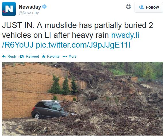
Long Island Mudslides. Photo and tweet above courtesy of
Newsday.
Rainfall Reports:
6.06" Unionside, NJ
5.98" 5 miles SW of Queens, NY (NYC)
5.82" Roslyn Heights, NY
5.72" Midwood, Brooklyn (NYC)
5.12" Central Park (NYC)
Also: Baltimore, MD finished 0.1" shy of a new record for an April rainfall record.
BWI Airport: 8.60" of rain in April; Record (1889): 8.70" Wednesday's 3.06" of rain at BWI airport tied a daily record (1947).
* data courtesy of Chris Bianchi at WeatherNation.
Arkansas Tornado Rated EF-4. That's about as powerful as they get, capable of scraping even well-built homes down to foundation. Here's an excerpt from
baxterbulletin.com: "...
The
scene was chaotic after Sunday’s storm: scraps of metal wrapped around
tree limbs, brick homes reduced to rubble, bark stripped from trees.
Tractor-trailers and heavy-duty SUVs were flipped over and flung like
toy cars. The nation hasn’t had an EF5 storm since last May, when Moore,
Okla., was hit by a twister that killed 24 and destroyed 1,000 homes.
There have been only 59 EF5 storms since modern record-keeping began in
1950. Some residents in the hard-hit communities of Vilonia and
Mayflower described hearing the storm, comparing it with the roar of a
freight train or jet engine. Mayflower Mayor Randy Holland described it
as “the loudest grinding noise I’ve ever heard...”
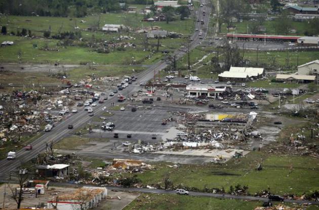
Photo credit above: "
This
Monday, April 28, 2014 aerial photo shows destroyed buildings and
debris along U.S. Highway 64 in Vilonia, Arkansas. Vilonia was hit hard
Sunday for the second time in three years. Four people were killed in a
2011 storm. Until this late April 2014 outbreak, the U.S. as a whole had
by far the quietest start of the year for tornadoes. Longer trends show
more tornado clusters recently." (AP Photo/Danny Johnston).
Truck Carried 27 Miles By Arkansas EF-4 Tornado.
When I first saw this headline I thought "that can't possibly be true".
But then I thought about the sustained updraft in a (confirmed) EF-4
with 180 mph. winds and I guess it's not beyond the realm of
possibility. Here's a clip from
USA Today: "
A
truck was reportedly carried 27 miles by a tornado Sunday night in
Arkansas, according to meteorologist Darby Bybee of KHBS-TV in Fort
Smith. Bybee reported that the truck was carried from Mayflower, Ark.,
to near Vilonia, Ark., a distance of about 27 miles. A report from the
National Weather Service in Little Rock notes that an EF-4 tornado --
with winds of at least 180 mph -- traveled 41 miles on a path that
included both Mayflower and Vilonia. The tornado killed 15 people..."
Photo credit above: "
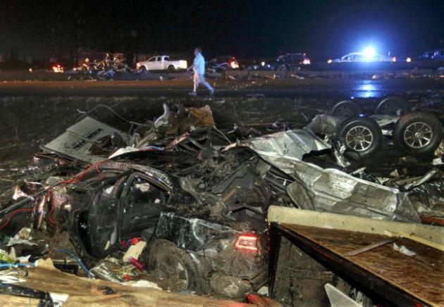
In
this Sunday, April 27, 2014 photo, a person walks past cars strewn
across Interstate 40 when a tornado struck the town of Mayflower, Ark. A
tornado system ripped through several states in the central U.S. and
left more than a dozen dead in a violent start to this year's storm
season, officials said." (AP Photo/The Arkansas Democrat-Gazette, Benjamin Krain).
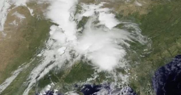
GOES Animation Of The April 27-28 Tornado Outbreak. You can see the supercell thunderstorms mushrooming to life, courtesy of NOAA and
NASA: "
This
animation of NOAA's GOES-East satellite data shows the development and
movement of the weather system that spawned tornadoes affecting seven
central and southern U.S. states on April 27-28, 2014." Credit: NASA/NOAA GOES Project.
* more details on using weather satellites to track tornadic storms from
Space Daily.
Tornadoes, Dust Storms and Floods. What The Hell Happened This Week?
There's a compelling body of scientific data that rapid warming of the
arctic may be slowing jet stream winds at northern latitudes, creating
more blocking patterns, more "closed lows" (sometimes called cut-off
lows) that stall for days at a time. As I've said repeatedly (ad
nauseum) over the years, when weather stalls bad things can happen.
Meteorologist Andrew Freedman has a good explainer at
Mashable; here's an excerpt: "...
Blocking
patterns such as this one often lead to extreme weather events,
especially temperature and precipitation extremes. For example, a blocking pattern across Europe and Russia in 2010 led to the deadly Russian heat wave that killed thousands and contributed to massive wildfires, as well as the disastrous Pakistan floods that occurred around the same time. Another blocking pattern resulted in the deadly 2003 European heat wave, which killed an estimated 40,000 people..." (graphic above: Mashable).
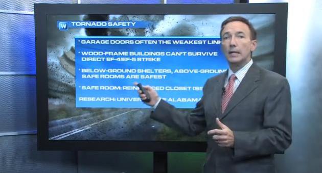
How Can We Make Homes Safer From Tornadoes?
Keying in on recent research from the University of Alabama, I take a
look a structural steps we can all take to lower the risk of
tornado-related damage. Step 1: reinforce your garage doors. That's the
subject of today's
Climate Matters.
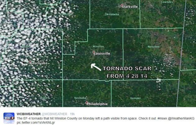
Tornado "Scar". You know it's a bad tornado when you can see the debris path from low Earth orbit. Here's an image passed along by
WCBI-TV of the EF-4 tornado that smashed into Louisville, Mississippi on Wednesday.
Tornado Survivors Install Safe Rooms.
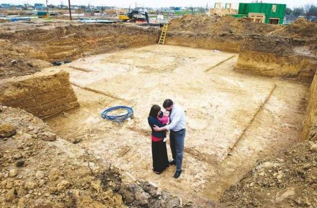
If you live in or near Tornado Alley, or Dixie Alley in the south, or
Hoosier Alley in the Ohio Valley, consider skipping 1 family vacation
and putting that money into a safe room. You may thank yourself down the
road. Here's a clip from a story at the
Pekin Daily Times in Pekin, Illinois: "...
Both
families are staying put, rebuilding their homes as the same locations.
This time, each home will have a concrete safe room, complete with a
steel door, in the basement. Their builders recommended adding a safe
room when asked about it. The Bowers inspected a safe room at a home in
rural Washington before making their decision. Neither couple could give
an exact figure of how much their safe room will cost, but they said it
will be in the hundreds, not thousands, of dollars..."
Small Changes Could Save Structures, Lives During Tornadoes, Reports UA-Involved Study. The
University of Alabama has the details; here's an excerpt: "
Surviving
a tornado in a wood-frame residential home is enhanced by an intact
roof and standing walls, but light-weight garage doors can be the weak
link to allowing high winds and pressure changes into a home that can
lead to the removal of the roof and collapsed walls, according to a study of damage left behind by a powerful tornado
in Moore, Oklahoma, in 2013 by researchers from The University of
Alabama and other institutions. “Once the roof over the garage is blown
off, there usually is a significant hole into the main portion of the
house,” said Dr. Andrew J. Graettinger, associate professor of civil, construction and environmental engineering and lead author of a report by a team of researchers..."
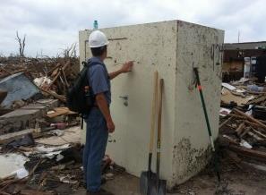
Photo credit above: "
Dr.
Andrew Graettinger, a University of Alabama researcher, examines a safe
room that survived the tornado that struck Moore, Oklahoma, in May 2013."
Origin Of "Tornado Emergencies". KOCO-TV
in Oklahoma City just ran a story explaining the origin of the term
Tornado Emergency, which implies a large, deadly, confirmed tornado on
the ground, moving into a more populated urban area. Here's an excerpt: "
It
all started with the National Weather Service in Norman. As the
meteorologists watched a large, violent tornado moving into town, they
asked themselves if they were doing all they could to get the message
out. Tornado warnings were common. But the term tornado warning is
somewhat vague. Is it doppler radar indicated? Is it a small tornado? Is
it a large tornado? The truth is it could be any. But on May 3, 1999 we
weren't dealing with just any old tornado warning. We had a monster on
our hands. And thus the need was there to hit the message as hard as
possible. And so at 6:57pm, a meteorologist in Norman added the word
"emergency" to this warning..."
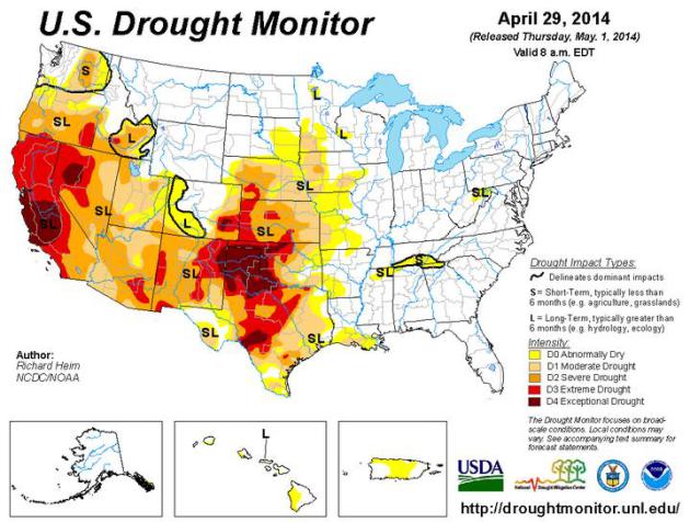
38% of Lower 48 States in Moderate to Severe Drought. Here is the latest interactive update from the
U.S. Drought Monitor.
3 Month Drought Progression.
Here's another perspective on the drought, showing how conditions have
changed since early February. Much of the Midwest has seen a rapid
improvement in the long-term drought, especially in the last week with
some 3-5" rains. The Pacific Northwest is also in better shape than it
was during the late winter months. But drought has intensified over the
central and southern Plains and much of the Southwest. Source:
U.S. Drought Monitor.
"There Will Be A Tsunami - The Question Is When"
Underwater quakes can trigger tsunamis, so can underwater landslides.
Israel has a history of tsunamis (which was news to me). Here's a clip
from
The Jerusalem Post: "...
While
earthquakes stronger than 7.5-magnitude have the potential to cause
tsunamis, they can also be caused by underwater landslides, Goodman
explained. The last tsunami recorded off Israel’s shores occurred in
1956, as a result of a large earthquake in Greek waters, she said. The
last tsunami to cause any damage in Israel happened in the 19th century
near Acre, she added. Caesarea most recently received a small tsunami in
the 12th century, according to Goodman..."
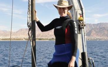
Photo credit above: "
Dr. Beverly Goodman conducts research in the Mediterranean Sea." Photo: MGM LABORATORY.
A Eulogy For Twitter.
I really like Twitter, and derive a fair amount of value from the
information streams and people/organizations I follow. It's often the
fastest way to get information, although accuracy sometimes suffers as a
result. Personally I hope it survives and thrives for the long haul,
but the folks at
The Atlantic are noticing some disturbing trends; here's an excerpt: "
We've
been trying to figure out the moment Twitter turned, retracing tweets
to see whether there was something specific that soured the platform. Something is wrong on Twitter.
And people are noticing. Or, at least, the kind of people we hang
around with on Twitter are noticing. And it's maybe not a very important
demographic, this very weird and specific kind of user:
audience-obsessed, curious, newsy. Twitter's earnings last quarter,
after all, were an improvement on the period before, and it added 14
million new users for a total of 255 million. The thing is: Its users
are less active than they once were. Twitter
says these changes reflect a more streamlined experience, but we have a
different theory: Twitter is entering its twilight..."
Image credit above:
Matthias Töpfer/flickr.
Foods To Help You Age Better. Are Oreos part of a healthy Mediterranean diet? Still checking on that. In the meantime here's an excerpt of a story at
PBS Next Avenue: "
But it’s a 2014 study that could tie it all together into one healthy diet plan.
As part of a five-year diet intervention, Spanish researchers asked
overweight older adults (aged 55 to 80) to follow a healthy Mediterranean diet
— whole grains, lots of produce, healthy fats, like olive oil — and
then followed measures of obesity: waist size, body mass index, waist to
height ratio. At the end of five years, participants showed
improvements in obesity parameters and in telomere length..."
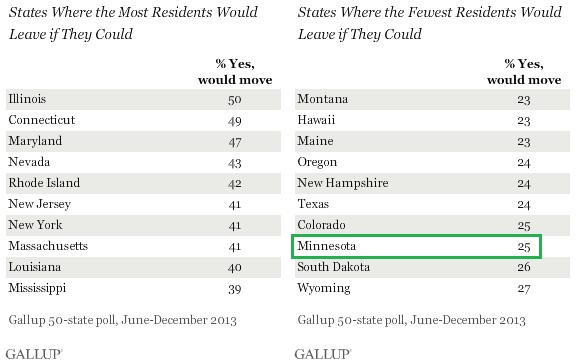
Half The People In Illinois and Connecticut Want To Move Elsewhere. Hey, it's only 1
out of 4 here in Minnesota, but the poll was taken before the Winter of
Our Discontent, before the toughest winter in 30 years. I wonder what
the number would be today? Here's a clip from
Gallup: "
Every
state has at least some residents who are looking for greener pastures,
but nowhere is the desire to move more prevalent than in Illinois and
Connecticut. In both of these states, about half of residents say that
if given the chance to move to a different state, they would like to do
so. Maryland is a close third, at 47%. By contrast, in Montana, Hawaii,
and Maine, just 23% say they would like to relocate. Nearly as few --
24% -- feel this way in Oregon, New Hampshire, and Texas..."
"Wireless Underwear" - Because A Guy Just Can't Be Too Safe.
If you're concerned about the RF signals coming out of that smart phone
nestled in your pocket, consider this new invention, designed to
protect your valuables.
Gizmag has details: "
Although
there is yet to be conclusive evidence that radiation emitted by mobile
phones and other wireless devices is damaging to male fertility, some
studies have shown at least a potential link. This is why the makers of
Wireless Armour have stepped in to try and provide some protection with
nothing less than underwear that encases your nether regions in a
Faraday cage..."
TODAY: Mostly cloudy, few showers. Winds: W 10-15. High: 56
FRIDAY NIGHT: Lingering clouds, still cool. Low: 40
SATURDAY: Partly sunny and breezy. Not bad.Winds: NW 10-20. High: 57
SUNDAY: Some sun, showers south/west of MSP metro. Wake-up: 39. High: 58
MONDAY: Early shower, then clearing. Wake-up: 43. High: near 60
TUESDAY: Springy again. Few T-storms. Wake-up: 45. High: 64
WEDNESDAY: T-storms, some heavy/severe? Wake-up: 50. High: 66
THURSDAY: Humid. More strong T-storms. Wake-up: 53. High: 72
Climate Stories....
- From Gavin Schmidt's TED Talk. Details below.
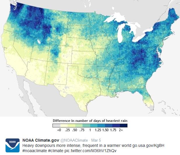
Heavy Downpours More Intense, Frequent In A Warmer World. Tell
that to residents of Pensacola...or Boulder...or Calgary...or
Nashville. Four thousand-year floods in Minnesota since 2004, according
to the local climate office. Here's an excerpt from
NOAA's climate.gov: "
According
to the 2009 National Climate Assessment, heavy downpours have increased
in frequency and intensity during the last 50 years. Models predict that downpours will become still more more frequent and intense as greenhouse gas emissions and the planet’s temperature continue to rise. The map (above) shows predicted changes in the annual number of days of extreme rainfall (defined
as rainfall totals in excess of the historic 98th percentile) across
the United States by 2041-2070 as compared to 1971-2000 if greenhouse
gases continue to increase at a high rate (A2 scenario). By mid-century,
some places could experience two or more additional days per year on
which the rainfall totals exceed the heaviest rains historically
experienced in the area..."
The Emergent Patterns of Climate Change.
The complexities, interactions and orders of magnitude when dealing
with the Earth's climate system are staggering. Here is a link to an
excellent primer, a
TED Talk on climate models and detecting signals amidst the noise of everyday weather, courtesy of climate scientist Gavin Schmidt: "
You
can't understand climate change in pieces, says climate scientist Gavin
Schmidt. It's the whole, or it's nothing. In this illuminating talk, he
explains how he studies the big picture of climate change with
mesmerizing models that illustrate the endlessly complex interactions of
small-scale environmental events."
U.S. Corn Yields Are Increasingly Vulnerable To Hot, Dry Weather, Stanford Research Shows. Here's a clip from
Stanford: "
Corn
yields in the central United States have become more sensitive to
drought conditions in the past two decades, according to Stanford
research. The study, which appears in the journal Science, was led by
Stanford's David Lobell, associate professor of environmental Earth
system science and associate director of the Center on Food Security and
the Environment. "The Corn Belt is phenomenally productive," Lobell
said, referring to the region of Midwestern states where much of the
country's corn is grown. "But in the past two decades we saw very small
yield gains in non-irrigated corn under the hottest conditions. This
suggests farmers may be pushing the limits of what's possible under
these conditions..."
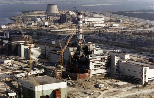
The Right Lessons From Chernobyl.
Clean, renewable power is the long-term answer, but in the short term
solar, wind, geothermal, tides, etc won't be able to provide the scale
we need to keep the lights on and the economy powered up. Here's an
excerpt of an Op-Ed from
The New York Times where they argue that the world still needs nuclear, with a few caveats: "...
The
center notes that since 1990 nuclear power has consistently supplied
about one-fifth of the nation’s electricity and more than 60 percent of
all zero-carbon electricity. The watchword here and in the world at
large should be prudence. Prudence in the design, maintenance and
operation of all nuclear facilities. Prudence also in the sense that
policy makers not be spooked into shutting down a vital source of clean
energy in a warming world. The great shield over Chernobyl should also
entomb unfounded fears of using nuclear power in the future..."
Photo credit: The Atlantic.
FOX Smears Science Editor As A "Coward" After He Exposes Network's Climate Change Ban.
But is there "football on other planets"? This is why I get all my
breaking science news from FOX News. They're on top of it. Here's a clip
from
Raw Story: "
The
hosts of the Fox News morning show Fox & Friends called Scientific
American editor Michael Moyer a “coward” on Thursday after he revealed
on Twitter that the network had barred him from talking about climate
change a day earlier. In a tweet
after his visit with Fox News on Wednesday morning, Moyer explained
that he wanted to talk about climate change during the “future trends”
segment but the producers told him
to “pick something else.” Moyer’s tweet obviously hit a nerve because
Fox & Friends lashed out at him in a second segment on Thursday that
was about 20 percent longer than the original interview..."









No comments:
Post a Comment