83 F. high in the Twin Cities Thursday.
82 F. average high on August 7.
77 F. high on August 7, 2013.
August 7, 1930: A record high of 102 is set at Redwood Falls.
Hawaiian Punch
Is
there a state with "perfect weather"? San Diego has the best climate in
America, on paper, but they're running out of fresh water. Hawaii has
to be near the top of the list, a tropical paradise where severe weather
is extremely rare.
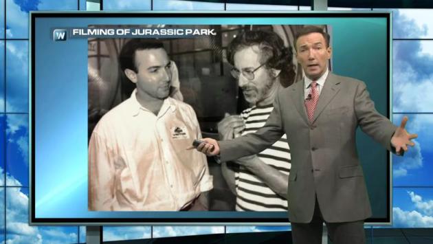
While helping with special effects for
"Jurassic Park" Steven Spielberg described how life imitated art. During
filming on Kauai in 1992 Category 4 "Iniki" struck. They evacuated
Spielberg and his film crew to the basement of the hotel. "You realize
you could have drowned from the storm surge. In a hurricane you want to
be on the third floor or higher" I told him. His eyes got very big. We
changed the subject.
"Iselle" just struck the Big Island with
near-hurricane force winds, for the first time on record. Maui and Oahu
will be brushed by tropical storm conditions; the rough equivalent of a
severe thunderstorm - one that lingers for 12-18 hours.
It puts
our Sunday T-storms into perspective. A ridge of high pressure keeps us
sunny, hazy & warm into Saturday. A storm may sprout late Saturday -
a better chance Monday - with a welcome dip in humidity by midweek.
But any storms will be small and brief, without names.
I can live with that.
Predicted Wave Heights.
The most significant (15-20 foot) waves should remain offshore, just
east of Hilo, but significant storm surge damage can't be ruled from
Iselle, especially on the windward (eastern) coast of the Big Island,
near Hilo. Source: NOAA.
Wind Damage Potential.
One of the models we look at (TAOS) shows potentially severe wind
damage in and around Hilo, with moderate to widespread damage from
sustained high winds across much of the Big Island. How the winds react
to encountering Mauna Kea and Mauna Loa, two towering volcanoes, is an
open question, since Big Island hasn't been hit by a hurricane or
tropical storm since at least 1949. Only light/minor damage is expected
from winds in Maui and Oahu, but heavy rains may spark flash flooding.
What To Expect From Hawaii's First Hurricane Landfall in 22 Years. Meteorologist Eric Holthaus has some interesting nuggets and perspective at
Slate; here's an excerpt that caught my eye: "...
Hawaiian hurricanes are rare. So rare that the National Weather Service doesn’t quite know what will happen,
especially with Iselle’s circulation interacting with the two huge
volcanoes on the Big Island, Mauna Kea and Mauna Loa. The volcanoes
could help to disrupt Iselle’s circulation, or they could even enhance
its winds. A message from the Central Pacific Hurricane Center in Honolulu highlighted the risk:
In
Hawaii, mountainous terrain accelerates hurricane and tropical storm
winds causing extremely high winds that can destroy buildings,
structures, trees, vegetation and crops..."
Animation credit: NOAA's WaveWatch III Model.
A
Real Close Encounter: How 1992 Hurricane Iniki Disrupted the Filming of
"Jurassic Park", and Put Steven Spielberg & Crew at Risk.
You can't make this stuff up. A previous company ("EarthWatch") helped
with some of the special effects in Jurassic Park - 3 dimensional
animations for control room scenes, with scientists tracking a mythical
storm approaching Jurassic Park. Foreshadow. In real life Category 4
Iniki chased the film's director, Steven Spielberg, and his crew into
the basement of the hotel as the real-life storm approached, which may
have been a precarious place to be. Remember, in a tornado you want to
be below ground, if possible, but with the storm surge risk near the
water in a hurricane you want to be on the third floor or higher of a
well-constructed building, away from outer walls and windows. That's the
unlikely topic of today's first
Climate Matters segment: "
Hurricane
Iselle brings back memories for Paul Douglas. He tells the story of a
meeting with Steven Spielberg when Hurricane Iniki impacted the
production of Jurassic Park and how Spielberg learned a valuable
hurricane safety tip."
Improved Long-Term Forecasts at Heart of National Hurricane Center's Goals. Claims Journal has an article focusing on new tools and capabilities from NHC, and a look at just how far we've come; here's an excerpt: "...
Our
track forecasts, for example, have been getting better year by year.
Since 1990, our 48 hour track errors have come down from 200 nautical
miles on average to about 70,” Franklin said. “Our three day forecast
errors have come down in that period from about 300 nautical miles to
100 today.” According to Franklin, intensity errors have remained stable
while storms have gotten stronger in a shorter amount of time..."
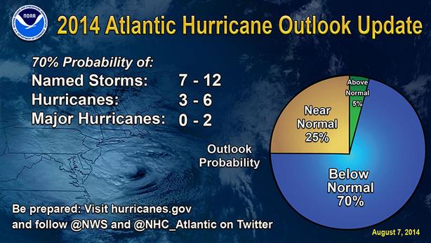
NOAA: Chances For Below-Average Hurricane Season Have Increased.
The Capital Weather Gang puts it all into perspective; here's the intro: "
If this year’s hurricane season has seemed quiet so far, it will likely continue to do so. In an update
to the Atlantic Hurricane Season Outlook, the National Oceanic and
Atmospheric Administration predicts there is a now a 70 percent chance
of a below-normal season. There is only a five percent chance of an
above-normal season. From NOAA: The updated hurricane season outlook,
which includes the activity to-date of hurricanes Arthur and Bertha,
predicts a 70 percent chance of the following ranges: 7 to 12 named
storms (top winds of 39 mph or higher), including 3 to 6 hurricanes (top
winds of 74 mph or higher), of which 0 to 2 could become major
hurricanes (Category 3, 4, 5; winds of at least 111 mph)..."
How Rare is "Iselle"?
The Hawaiian Islands have been hit by 2 hurricanes since 1949: Dot in
1959 and Category 4 Iniki in 1992. Since 1949 the Big Island, Maui and
Oahu have only been brushed by tropical depressions. Here's some
additional perspective in our second installment of
Climate Matters: "
Hurricane
Iselle bears down on Hawaii and should make landfall soon. That got us
thinking. How rare are hurricanes in the Hawaiian Islands?
WeatherNationTV Chief Meteorologist Paul Douglas has more information in
this Climate segment."
Isolated Saturday Storms.
The farther west you travel, away from MSP, the better the odds of a
stray T-storm or two late Saturday and Saturday night, in response to a
weak upper level disturbance. Latest guidance suggests Sunday may
actually be the sunnier, warmer, drier day, with T-storms potentially
holding off until Sunday night.
Steamy Into Monday, Then Relief.
Highs poke around in the low 80s today, Saturday and Sunday before
cooling off slightly next week. After a spirited round of Monday
T-storms (wettest day in sight) dew points drop off into the upper 40s
and low 50s by midweek, so it will feel a lot more comfortable out
there. A slow warming trend, and rise in humidity levels, is likely
again toward the end of next week. Graph: Weatherspark.
60-Hour Accumulated Rainfall.
More flash flooding is possible from the Middle Mississippi Valley into
the Tennessee Valley as storms train along a lingering boundary; some
3-5" amounts can't be ruled out. Most instability storms puff up west of
MSP into Saturday, but a stray storm could drift into the metro late
Saturday or Saturday evening. 4 KM WRF data: NOAA and HAMweather.
Minnesota: Cooler than Average July, Still Drought-Free! No kidding. Here's an excerpt of a post from the
Minnesota DNR:
- July precipitation totals
across Minnesota were light in all but a few locations. In some
portions of southwest and south central Minnesota, monthly rainfall
totals were less than one inch. July rainfall in most counties fell
short of historical averages by one to three inches.
[see: July 2014 Precipitation Map | July 2014 Precipitation Departure Map | July 2014 Climate Summary Table]
- The most notable heavy rain and severe weather event
of July occurred on the evening of the 21st and the early morning hours
of 22nd. Severe storms swept through portions of northern Minnesota
bringing damaging winds and torrential downpours.
[see: Heavy Rain and Severe Storms: July 21-22]
- Average monthly temperatures for July
in Minnesota were two to three degrees below the historical average at
most locations. Extremes for July ranged from a high of 96 degrees F at
Hutchinson on the 21st, to a low of 36 degrees F at Brimson (St. Louis
County) on the 4th and Embarrass (St. Louis County) on the 16th.

Californians Have The Perfect Solution To The Drought - Paint The Lawn Green.
I can't tell you how many times I wanted to do the same thing, or
replace grass with no-maintenance mulch. Green dirt? Here's a clip from a
story at
Quartz: "...
The
story is far from unique. Companies that promise to paint lawns are
cropping up all over California. The service lets homeowners cut back on
water use without sacrificing curb appeal. But
the cosmetic cover-up masks an ugly reality: The Golden State is three
years into what has now become its worst drought on record. And it’s
only getting worse. The US
Drought Monitor upgraded the intensity last week with a warning that
more than half the state is now experiencing “exceptional” drought—the
most severe category, according to federal researchers..."
Photo credit above: "It will just smell different." AP Photo/Damian Dovarganes.
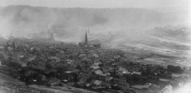
Photos: Johnstown Then And Now, Embracing The History of Flood City.
I don't think any of us can imagine what it must have been like when a
wall of muddy water and debris overwhelmed the city of Johnstown, like
an inland tsunami. NewsWorks does a good job of capturing the horror, and recovery - here's a clip: "...In
June 1889, newspapers from around the world published sensational
headlines that read "Horros of Horrors," "Awful Calamity. Johnstown
Wiped Out!" and "Fire Finishes All Left By The Flood."
On the last day of May, the South Fork Dam collapsed — sending a wall
of water nearly 40-feet high from the man-made Lake Conemaugh, 14 miles
through the river valley to Johnstown, Pennsylvania. Houses, churches,
train cars and trees were ripped from foundations and swept away in
flood waters. Piles of debris rushed down the Little Conemaugh River and
became trapped in the arches of the Pennsylvania Railroad Stone Bridge
near the center of Johnstown..."
Photo credit above: "
Johnstown Then and Now. Bird's eye view of Johnstown, Pa. after the flood of 1889." (Image courtesy of the Library of Congresss)
The $2 Trillion Risk You Haven't Heard About.
Maybe you have, if you've been paying attention. I've posted a few
articles about the risk of a major X-Class solar flare (G4 or G5
strength) and what it could do to not only communications but the grid.
It's something our corporate customers are most concerned about, even
more than hurricanes and rising seas. Here's an excerpt from The PBS NewsHour: "There’s
a 12 percent chance of something really disruptive hitting Earth in the
next decade. How worried should we be? Very, says astronomer Donald
Goldsmith. To put that risk in context, that’s about the same likelihood
of another earthquake striking California. But the risk Goldsmith warns
about is a lot less publicized: a type of solar flare, known as a
coronal mass ejection, could cause economic damages up to $2 trillion,
according to the National Academy of Sciences. (NewsHour science
reporter Jenny Marder explained how the sun ejects these balls of gas in
this 2011 story.) These potentially destructive solar storms are in the news
this summer because of a recently published paper revealing just how
close a CME came to hitting Earth two years ago. If this extreme solar
storm had hit in July 2012, the University of Colorado’s Daniel Baker said, “We’d still be picking up the pieces....” (File photo above: AP).
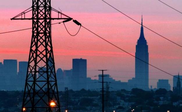
See Power Plants Most Vulnerable to Flooding.
Climate Central
has an article and links to new tools that focus in on infrastructure,
including power plants, most susceptible to storm surge, river and flash
flooding. Here's an excerpt: "
It doesn’t take rising seas for electric power plants and other energy infrastructure in the U.S. to flood. Major 100-year floods can do that without the help of climate change. The U.S. Energy Information Administration’s new mapping tool
announced Wednesday shows how such a flood could drown some of the
nation’s most critical energy infrastructure — power plants, oil and gas
wells, solar power installations, etc..."
Map credit above: "U.S.
Energy Information Administration map of the flooding potential in
Tampa, Fla. The blue shade represents 100-year flood risk, encompassing
power plants south of downtown."
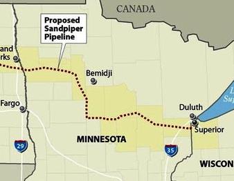
Bakken Oil Pipeline Would Bisect Minnesota, Cross 144 Waterways.
InsideClimateNews has details that had me sitting up a little straighter in my chair - here's an excerpt: "...
The
616–mile Sandpiper pipeline is one of the first major pipelines
designed to carry crude oil out of the booming Bakken Shale region of
North Dakota. It will begin in the northwest corner of North Dakota and
cross into Minnesota then pass 299 miles through the heart of the state
to Superior, Wisc. Once running, it could carry nearly 10 million
gallons of crude oil a day—an estimated 20 percent of the oil produced
in the Bakken—to refineries in the Midwest and East and Canada...Yet the
Minnesota Pollution Control Agency
(MPCA) has faulted the proposed route, saying it "shows a significantly
higher potential for environmental damage" than other possible routes.
It is asking for a detailed risk analysis of the proposed route that
assesses the potential for leaks, how much oil might be spilled, and how
it could affect groundwater, surface water and aquatic life..."
Map credit above: Paul Horn/InsideClimate News.
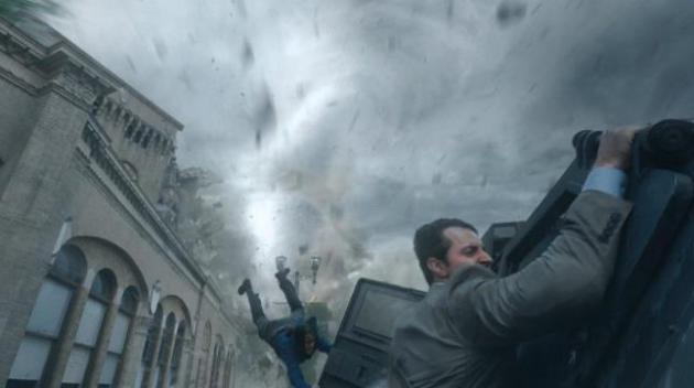
Box Office: Why "Into The Storm" Might Hit Hardest in Tornado Alley. The movie, an unofficial sequel to "Twister" (?) kicks off this weekend; here's a clip from
The Hollywood Reporter: "...
Remembering how well Twister did, many Midwestern theater chains expect a bump for Into the Storm, directed by Steven Quale and starring Richard Armitage and Sarah Wayne Callies. "Especially in Oklahoma and southern Missouri, it should be really strong," says Brock Bagby, director of programming at Kansas-based theater chain B&B Theatres,
which has locations throughout the Midwest. "I don't know if it's
coping or it's just more interesting because it affects them," he tells The Hollywood Reporter. "In L.A.,
you’ve never seen a tornado." An executive at one of the country’s
largest chains agrees. "I haven’t heard any complaints," he says..."
Image credit courtesy of Warner Bros. Entertainment Inc.
Tidal Power Generator Unveiling Hailed as Landmark.
Power from the natural tidal ebb and flow of the seas? If costs
continue to come down (much like solar) it could be another viable,
zero-carbon source of electricity. Here's a snippet from
The BBC: "...
The
150-tonne demonstration device with a frame as high as a seven-storey
building has been built in Pembroke Dock by Mustang Marine, recently
saved from administration. It will generate energy from tidal currents
on the sea bed. Tidal Energy Ltd claims the patented DeltaStream device
will be Wales' first grid-connected freestanding tidal turbine..."
Photo credit: Tidal Energy LTD. "
Seven-storey high generator has been built by Mustang Marine in Pembroke Dock."
This Car May Soon Be The World's First Street-Legal Vehicle Powered By The Sun.
The Washington Post has the story - here's the intro: "
Hayden
Smith and his racing team are euphoric. They had spent the last weekend
of July obliterating a world speed record that had stood for more than a
quarter of a century. Once certified, the Sunswift eVe, built by
students hailing from Australia’s University of New South Wales will
reign as the fastest electric car to cover 500 kilometers (310 miles).
More importantly, the achievement brings it one step closer towards
becoming the world’s first street-legal solar-powered car..." (Image credit: "
Meet the Sunswift eVe.")
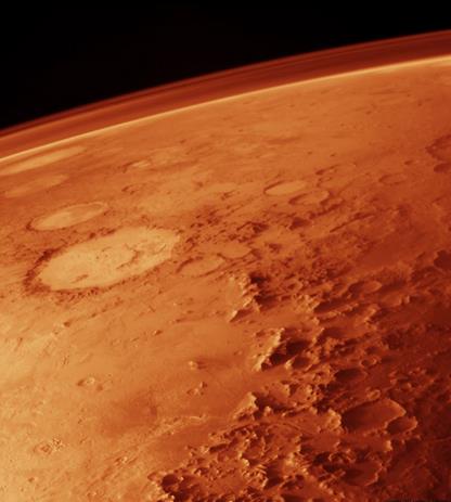
Is A One-Way Journey (to Mars) Wrong?
I can think of a number of people I'd love to send on a one-way journey
to the Red Planet. I'll bet you could list a few people too. Let's
start a petition. In the meantime a writer at the online community site,
Mars One, explains why a few (crazy) folks might be inspired to take a one-way trip: "...
Is
a one-way mission insane? Here's how Mason Peck responded to the
question: "There are many motivations for becoming one of the first
settlers on Mars, none of them insane in my opinion. These include:
*
A noble sense of self-sacrifice, in you believe that extending human
presence into the solar system will help to ensure the survival of the
species."
* A desire for the immortality that comes with
fame, despite the risk to life and limb. In some sense, putting
yourself at risk helps ensure your influence on the history of humanity
will outlive your physical being..."
TODAY: Warm sun, PM T-storms southwest MN. Winds: E 10. High: 82
FRIDAY NIGHT: Partly cloudy metro, storms southwestern MN. Low: 64
SATURDAY: Hazy sun, T-storm possible late, especially west of MSP. Dew point: 60. Winds: SE 10. High: 82
SUNDAY: Warm sun, sticky. Storms north/west Minnesota. Wake-up: 66. High: 84
MONDAY: More numerous T-storms, locally heavy rain. Dew point: 66. Wake-up: 67. High: 79
TUESDAY: Sunnier, turning less humid. Dew point: 53. Wake-up: 61. High: 76
WEDNESDAY: Bright sun, light winds. Dew point: 48. Wake-up: 56. High: near 80
THURSDAY: Partly sunny, seasonably warm. Wake-up: 59. High: 80
Is a one-way mission insane? Here’s how Mason Peck responded to the question:
“There are many motivations for becoming one of the first settlers on Mars, none of them insane in my opinion. These include:
- “A
noble sense of self-sacrifice, if you believe that extending human
presence into the solar system will help ensure the survival of the
species."
- “A desire for the immortality that comes with fame,
despite the risk to life and limb. In some sense, putting yourself at
risk helps ensure your influence on the history of humanity will outlive
your physical being."
- “A desire for personal accomplishment, or
overcoming a challenge, the same sort of thing that drives people to
join expeditions to the summit of Mount Everest."
- See more at: https://community.mars-one.com/blog/is-a-one-way-journey-wrong#sthash.8TpgtvHE.dpuf
Climate Stories...
For Most Of Us A Warmer World Has Become "The New Normal". Here's an excerpt of a story from Reuters and
Huffington Post: "
Global
warming has been going on for so long that most people were not even
born the last time the Earth was cooler than average in 1985 in a shift
that is altering perceptions of a "normal" climate, scientists said.
Decades of climate change bring risks that people will accept higher
temperatures, with more heatwaves, downpours and droughts, as normal and
complicate government plans to do more to cut emissions of greenhouse
gas emissions. "Because the last three decades have seen such a
significant rise in global and regional temperatures, most people under
the age of 30 have not lived in a world without global warming," Michel
Jarraud, Secretary-General of the U.N.'s World Meteorological
Organization (WMO), told Reuters..."
NOAA: Ocean Acidification Rises, Marine Economy Sinks. Here's a clip from an article at
EcoWatch: "...
But a new study, funded by the U.S. National Oceanic and Atmospheric Administration (NOAA), says growing acidification of Alaska’s waters,
particularly those off the southern coast, threatens the state’s whole
economy—largely dependent on the fishing industry. The study, which
appears in the journal Progress in Oceanography, says that not only will the state’s commercial fishing sector be badly hit by a growth in acidification, but it will also affect subsistence fisherpeople whose diet mainly consists of the catch from local waters..."
 What CEO's Are Starting To Do About That "Huge Gap" Obama Mentioned.
Companies stated sustainability intentions vs. what they spend on D.C.
corporate lobbyists to maintain the status quo are often at odds,
according to this piece from Eric Roston at
Bloomberg; here's a clip: "...
A consultancy based in Stamford, Connecticut, called Framework LLC, in 2011 compared sustainability reports and corporate 10-K disclosures for the 100 top companies chosen annually by Corporate Responsibility Magazine. The study found
that just eight companies had "a large degree" of overlap between 10-K
and sustainability reports: Merck & Co., Campbell Soup Co., Intel
Corp., Freeport-McMoran, Weyerhaeuser Co., Newmont Mining Corp, Xcel
Energy and Coca-Cola Co. Twenty-eight companies had disclosures that
raised "somewhat" similar topics and 60 had minimal overlap. Four didn't
intersect at all..."
Climate Change Damages Europe's Forests.
Climate News Network has the story - here's an excerpt: "...
The
authors show that damage caused by forest disturbance has increased
continuously over the last 40 years in Europe, reaching 56 million cubic
metres of timber annually in the years from 2002 to 2010. Analysis of
scenarios for the decades ahead suggest this trend will continue, with
the study estimating that forest disturbance will increase damage by
another million cubic metres of timber every year over the next 20
years. The study says this increase is roughly equivalent to 7,000
football fields’ worth of timber. The authors say climate change is the
main driver behind the increase. Forest disturbance did not increase
much beyond present levels in their simulations while climate conditions
remained stable..."








.jpg)

No comments:
Post a Comment