34 F. high in the Twin Cities Friday.
38 F. average high on November 21.
39 F. high on November 21, 2013.
November 21, 1996:
Heavy snowfall accumulated over the same areas that were hit two days
earlier. Four to seven inches of snowfall were reported across the area.
Heavier snowfall occurred during the daylight hours of the 23rd.
Snowfall totals of six inches were reported in the Twin Cities,
Chanhassen, Stewart, St. James and Redwood Falls.
November 21, 1970: Gale driven snow across Minnesota. 45 mph winds over Rochester and Duluth.
Coldest Minnesota November Since '96
To
receive my meteorology degree I had to pass 6 calculus courses. Which
explains why I still can't balance my checkbook. I'm no math major - but
by my calculations we just went 12 days in a row below 32F, the
most consecutive sub-freezing November days since 1880.
Here
in the Land of Feeble Weather Expectations FREEZING can feel like an
epiphany. Pathetically poetic. I'll be firing up the grill as
temperature surge into the upper 30s today and low 40s Sunday.
A
sloppy southern storm tracks well east of Minnesota, brushing us with a
little drizzle, maybe a coating of slushy snow Monday, but no
meteorological travesties are brewing close to home between now and
Thanksgiving. A reinforcing cold front arrives Wednesday with a quick
burst of fluff; highs Thursday hold in the teens with a subzero wind
chill.
I see more volatility in the pattern, more big swings in
temperature. Models hint at 30s returning late next week for
power-shopping; even a few 40s as we ease into December. According to
Dr. Mark Seeley November has been the coldest since 1996.
California
is finally seeing rain - El Nino is kicking in. Yes the cold came
early, but I'm still not convinced another polar vortex winter is
imminent.
Coldest Minnesota November Since 1996. Surprised? Me neither. Here's a link to
Mark Seeley's WeatherTalk: "...
Following
the winter storm of November 10th, cold air has dominated the state.
Through November 20th average monthly temperatures are running from 6 to
9 degrees F colder than normal, marking the coldest November since
1996. A streak of 12 consecutive days with no temperature reading of 32
degrees F or higher at MSP is the 2nd longest for the month of
November, topped only by 15 consecutive days back in 1880. Pete Boulay
of the Minnesota State Climatology Office has a nice feature on this..."
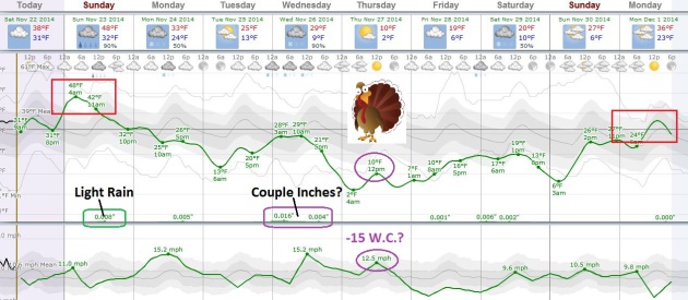
Temperature Roller Coaster.
Enjoy any hints of warmth over the weekend because another temperature
tumble is shaping up next week; the arrival of another January-like
punch setting off a couple inches of snow on Wednesday. Windchills on
Thanksgiving Day may dip as low as -15F in the metro, colder across
greater Minnesota. Temperatures recover slightly by the weekend; models
still hinting at 30s, even a couple 40s the first week of December.
Graphic: Weatherspark.
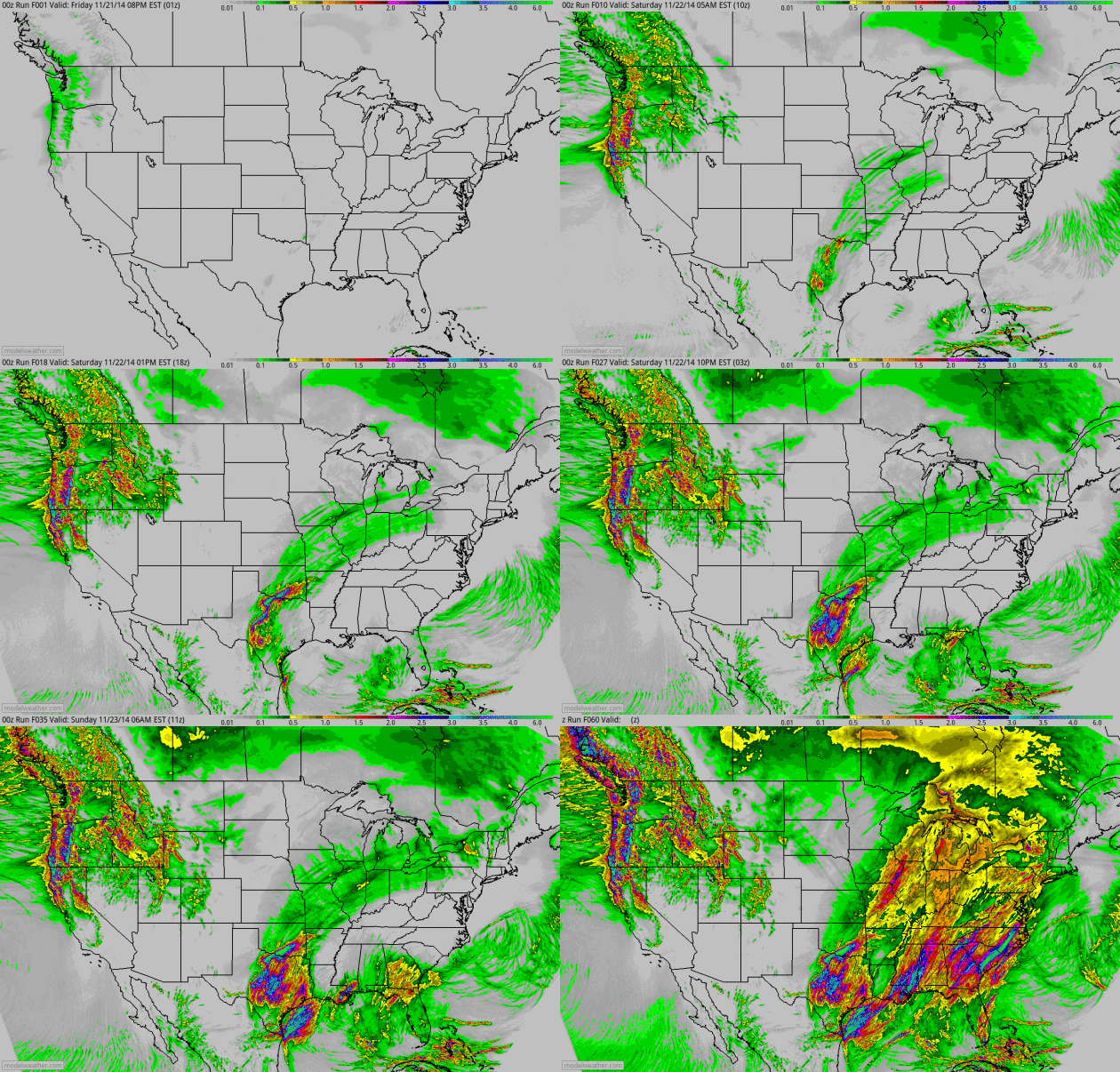
60-Hour Accumulated Precipitation.
California finally sees some welcome rains, heavy at times north of the
Bay area with a healthy soaking for much of the Pacific Northwest.
Meanwhile a surge of moisture from the Gulf of Mexico pushes from Texas
into the Great Lakes, ending as wet snow for parts of the Midwest.
Buffalo will see rain and 50s into Monday before cooling back down later
in the week with another slug of lake effect snow.
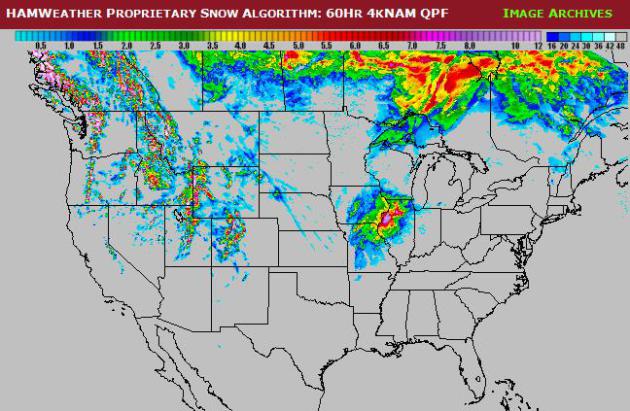
60-Hour Snowfall Potential.
Ham Weather's proprietary "Aeris" computer models show a potential for
plowable snow from near the Quad Cities to Quincy and Rockford,
Illinois; more heavy snow from near Park City, Utah to the Great Falls,
Montana. Map: HAMweather.
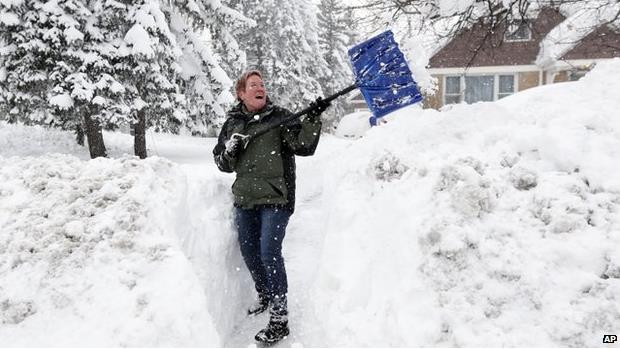
Why Do So Many People Die Shoveling Snow?
Because they're out of shape, have an undiagnosed coronary condition,
and because shoveling is even more strenuous and taxing than running on a
treadmill. Here's an excerpt of a post at
BBC that caught my eye: "...
His
team found that when healthy young men shoveled snow, their heart rate
and blood pressure increased more than when they exercised on a
treadmill. "Combine this with cold air, which causes arteries to
constrict and decrease blood supply, you have a perfect storm for a
heart attack," he says. Snow shoveling is particularly strenuous because
it uses arm work, which is more taxing than leg work. Straining to move
wet and heavy snow is particularly likely to cause a surge in heart
rate and blood pressure, Franklin says..." (Photo credit: Associated Press).
Snow Shoveling 101: How Not To Kill Yourself. Yahoo Health has some
good advice.
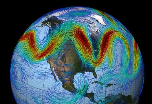
Snowed Under and Frozen Over: U.S. Weather Is Off The Rails, But Why?
The jet stream is "drunk" once again - memories of last winter have
emerged much sooner than anyone wanted or expected. Will it continue,
and how is a rapidly warming Arctic impacting prevailing steering winds?
Here's an excerpt of an explanation at
Capital Weather Gang: "...
Last
summer we saw the 6th lowest sea-ice minimum extent, and the extremely
warm temperatures now over the Arctic are from all the extra heat
absorbed by the Arctic Ocean where ice was lost,” Francis said. “When
the Arctic is so warm, the west winds of the jet stream weaken, and this
favors the highly wavy pattern to the jet stream responsible for this
early winter chill in the eastern U.S as well as the continued drought
and heat in California....”
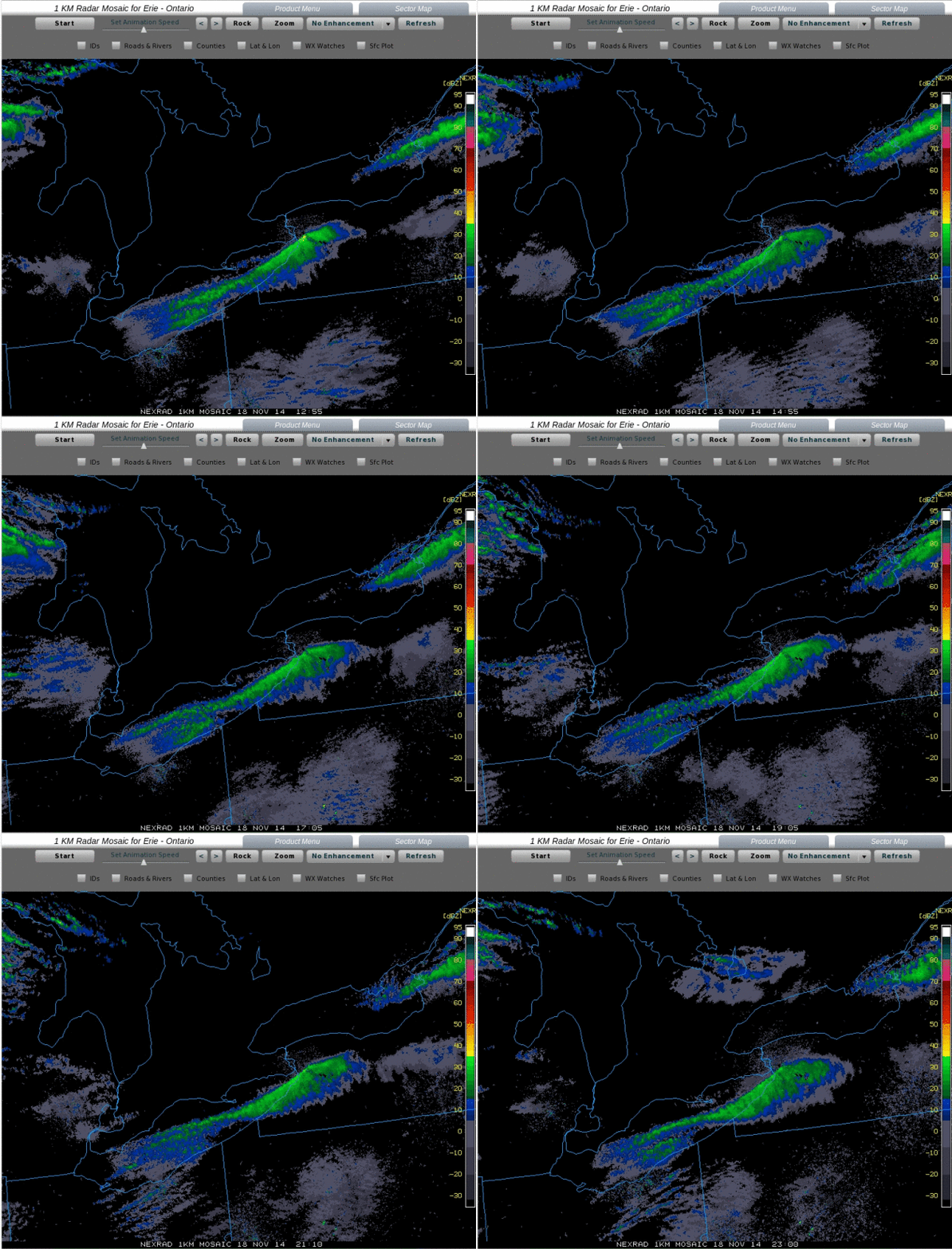
Winter Equivalent of Training Thunderstorm Echoes.
The great irony is that there was enough instability with the severe
snow event in Buffalo for thunder and lightning. It was ultimately a
combination of factors: water temperatures in the eastern end of Lake
Erie in the low to mid 50s, unseasonably cold air at the surface, and
even colder temperatures aloft resulting in extreme instability. Mean
wind vectors kept the most explosive snow band virtually stationary for
the better part of 48 hours, resulting in some 70-90" amounts. Tuesday
radar loop above courtesy of the
University of Wisconsin CIMSS.
 Unraveling The Mysteries of Deadly "Firehose" Lake Effect Snow Events
.
Every lake effect snow event is different, but what are the ingredients
that go into historic snowfalls? Are lake effect snows downwind of Erie
and Ontario some of the heaviest on earth? Andrew Freedman has a
fascinating story at
Mashable; here's an excerpt: "...
Jim
Steenburgh, a meteorology professor at the University of Utah, said the
Buffalo storm's first round confirms some of what he and his colleagues
observed in high-resolution last year. These storms can have a
“structure that’s really incredible… a structure that you sometimes see
with severe thunderstorms,” he told Mashable. From Tuesday through
Wednesday, the narrow band of heavy snow that targeted towns such as
West Seneca, New York, on Tuesday night, was barely 15 miles wide but
more than 100 miles long. In chilling photographs, it resembled a wall
of snow more closely akin to a broiling dust storm than a snow squall..."
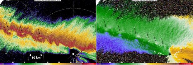
Image credit above: "
Radar
imagery from the Doppler on Wheels (DOW) mobile radar, operated by the
Center for Severe Weather Research, collected during the NSF-sponsored
OWLeS project. Left panel is radar reflectivity (length scale is added);
Right panel is Doppler velocity. Arrows show location of small
vortices. X marks location of radar." Image: Karen Kosiba/CSWR.
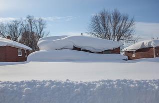
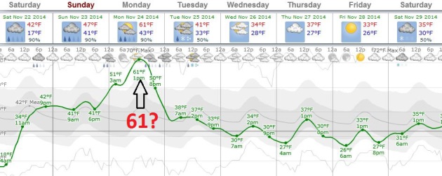
More Evidence of Weather & Climate Volatility: Heavy Rain and 60F for Buffalo by Monday?
ECMWF data suggests a high near 60F Monday afternoon, in spite of small
mountains of snow, especially on the south side of Buffalo.
The Los Angeles Times
has a story recapping the flash flood risk that could materialize early
next week. I'm especially worried about rain falling on snow-covered
rooftops, adding additional weight with more cave-ins likely. Graphic:
Weatherspark.
Flash Flood Watch for western New York, including metro Buffalo.
The concern is heavy rain and 50s adding additional weight to the
snowpack on area rooftops, resulting in more collapses into next week.
Details from
The Buffalo News.
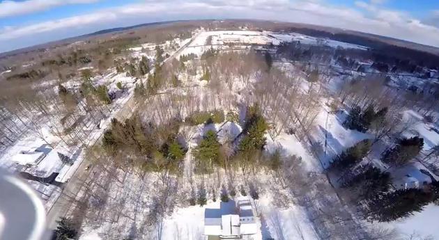
Tracking Buffalo's Snow Blitz With Drones? TVSpy has the story and video. Here's an excerpt: "
Buffalo
stations were able to give viewers the softer side of the aftermath of
Lake Effect snow with video shot by Jim Grimaldi’s drone. The local
drone pilot didn’t go far enough or high enough to trigger any action
from the FAA, but he did give WIVB and WGRZ some nice bump video showing how a snowstorm can change a neighborhood. WKBW featured the video on its website. Check it out..."
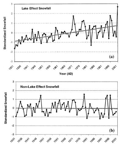
Global Warming Is Probably Boosting Lake Effect Snows. Here's an excerpt of an excellent article from meteorologist Eric Holthaus at
Slate,
showing how a gradual warming trend (and less ice cover) is creating
conditions more favorable for more lake effect snows: "...
Another massive early-season lake-effect event occurred in Buffalo back in October 2006,
when Lake Erie water temperatures were even warmer than they were this
week. Almost a million people lost power. Lake Erie is warming (along
with the rest of the planet) by a steady but measurable amount.
Since 1960 that trend has been about a half of a degree Fahrenheit per
decade. More important than this, though, Lake Erie has been losing its
ability to freeze over in the winter, with a decline of about one
sub-freezing day per year in recent decades..."
* graphic above from a 2003 paper by Burnett, et all available via PDF
here.
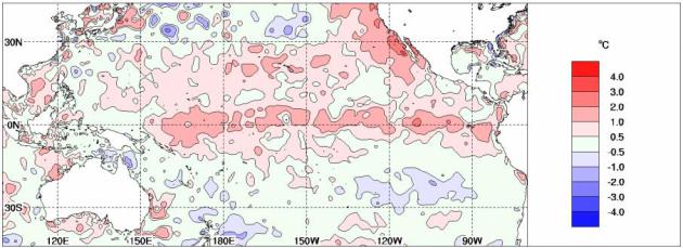
Tropical Pacific Ocean Moves Closer to El Nino. The odds of an El Nino have risen to 70% according to Australia's
Bureau of Meteorology; here's an excerpt of a recent release: "
The
Pacific Ocean has shown some renewed signs of El Niño development in
recent weeks. Above-average temperatures in the tropical Pacific Ocean
have warmed further in the past fortnight, while the Southern
Oscillation Index (SOI) has generally been in excess of El Niño
thresholds for the past three months. Climate models suggest current
conditions will either persist or strengthen. These factors mean the
Bureau's ENSO Tracker Status has been upgraded from WATCH to ALERT
level, indicating at least a 70% chance of El Niño occurring..."
NOAA: Globe Sets 5th Hottest-Month Record of 2014.
Some temperature "pause". The eastern USA has had a chilly year, but
that's more than compensated for by the rest of the planet, on it's way
toward what may be the warmest year on record. The 6 warmest months on
record for global ocean water temperatures have been in the last 6
months. Here's an excerpt from the AP and
wsbtv.com: "
Despite
a bitter U.S. cold snap, the globe is rushing hell-bent toward its
warmest year on record with last month setting the fifth monthly heat
record of year. The National Oceanic and Atmospheric Administration
announced Thursday that last month was the hottest October on record
worldwide. The 58.43 degrees Fahrenheit (14.74 Celsius) beat out October
2003. "It is becoming pretty clear that 2014 will end up as the warmest
year on record," said Deke Arndt, climate monitoring chief for NOAA's
National Climatic Data Center in Asheville, North Carolina. "The
remaining question is: How much?..."
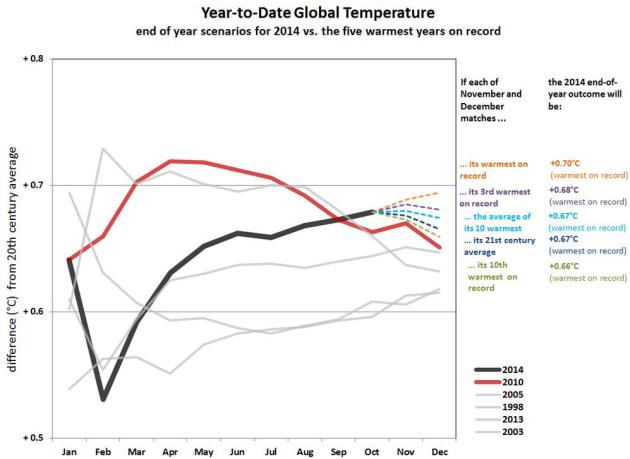
2014: On Track For The Warmest Year, Worldwide, On Record?
It may be close, but what makes this even more unusual is that 2013 and
2014 weren't El Nino years, no Pacific warmth turbocharging the
atmosphere. Here's an excerpt from
NOAA NCDC: "
The
years 2013 and 2014 are the only years on this list not to begin during
a mature El Niño event. The years 1998 and 2010, each of which became
the warmest year on record at the time, ended the year in a strong La
Niña event, as evidenced by the relative fading of global average
temperature later in the year. The anomalies themselves represent
departures from the 20th century average temperature. The graph zooms
into the warmest part of the entire history. For a broader perspective
on how these five years relate to the long-term record, click here..."
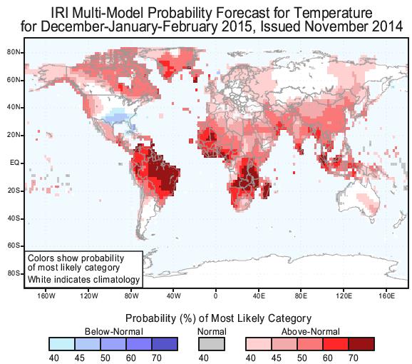
Winter Outlook from Columbia University. This is from
The International Research Institute
for Climate and Society, at Columbia Unversity's Earth Institute. Of
course all long-range seasonal outlooks should be taken with a big grain
of salt, but I couldn't get over how much red (warmer than average) is
predicted for the planet from December into February.
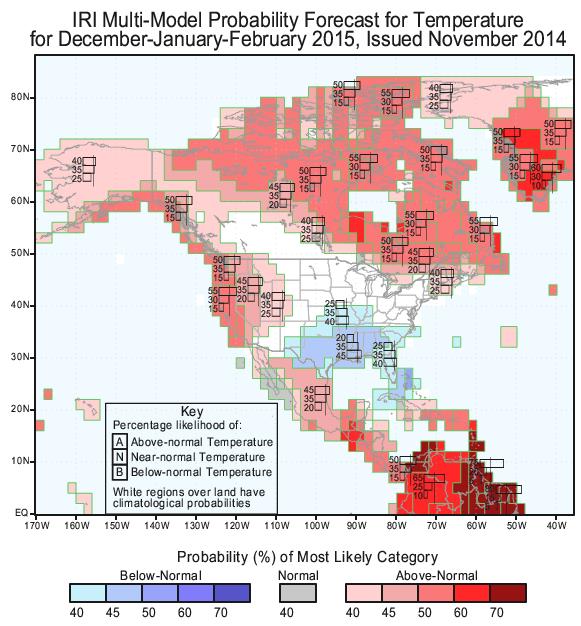
Average Winter Temperatures for Minnesota? It's too early to celebrate, but at least one longer-range climate model from
Columbia University
is forecasting a notable lack of polar air for much of North American
from December into February; warmer for much of the western USA
(consistent with a developing El Nino), warmer for much of Canada, the
Arctic and Greenland, colder than average for the southern USA.
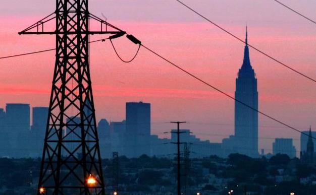
The U.S. Government Thinks China Could Take Down The U.S. Power Grid. Let's change the subject and turn over the sports scores. Quickly, while the power is still on.
CNN has the story and video; here's a clip: "...
China
and "probably one or two other" countries have the capacity to shut
down the nation's power grid and other critical infrastructure through a
cyber attack, the head of the National Security Agency told a
Congressional panel Thursday. Admiral Michael Rogers, who also serves
the dual role as head of U.S. Cyber Command, said the United States has
detected malware from China and elsewhere on U.S. computers systems that
affect the daily lives of every American..." (File photo: AP).
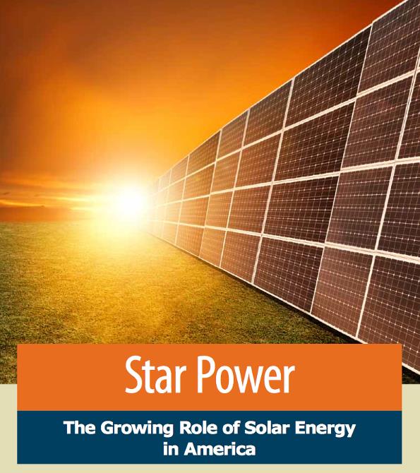
Solar Energy Could Power America 100 Times Over.
Ecowatch has the article - here's the introduction: "
America could meet its energy needs by capturing just a sliver of the virtually limitless and pollution-free energy that strikes the nation every day in the form of sunlight.” That’s the assertion of a new report Star Power: The Growing Role of Solar Energy in America, released today by Environment America.
Enough
sunlight strikes the U.S. every year to power the country 100 times
over, say the report’s authors, and 35 million homes and businesses
could potentially host solar panels..."
Dear Santa: All I Want For Christmas Is My Own (Video-Enabled) Quadcopter. A friend of mine, Cleveland TV meteorologist Andre Bernier, sent me
this video clip taken with his DJI Phantom 2 RTF Quadcopter, outfitted with GoPro 4k camera. The quadcopter
retails for $679,
but by the time you set it up for high-resolution video the costs can
top 2k. It can fly as high as 5,000 feet before it loses its signal, but
a 400 foot ceiling is mandated by the FAA outside class B and C
airspace. Andre writes: "
The Phantom 2 is the "industry drone standard" so-to-speak. You can configure it any way you like. I have mine with a Genmuse gyro-stablized gimball that holds a GoPro Hero 4 Black camera (can shoot 4K @30fps OR 1080HD @120fps!). I later added a video transmitter so I could see what the camera was seeing with an HD monitor attached to the radio controller. The DJI Phantom 2 is way under $700 nowadays (without gimball and camera) They used to be $3,000 (bare) a few years ago. By the time you add a camera, gimball, FPV transmitter and monitor, you're looking at right around $2,200 ready-to-fly." Sweet.
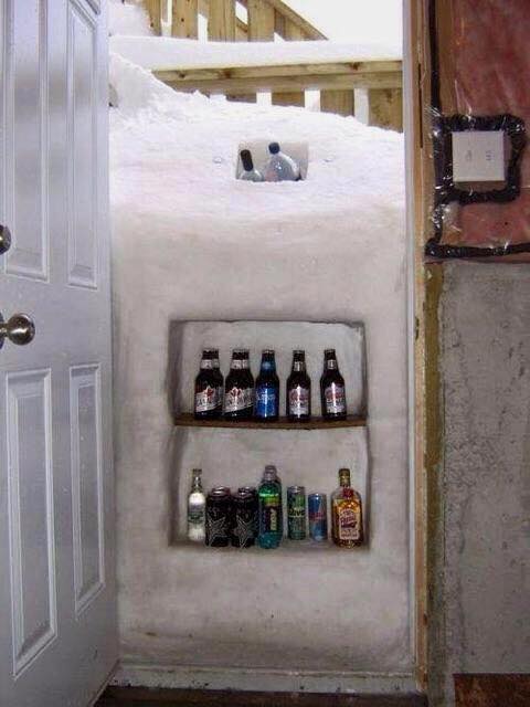
A Real Buffalo Beer Lover.
Well, this is one way of coping with a snowy emergency. If you can't
get out the door, and you still want to keep the beer cold - improvise.
Thanks to
Dr. Roy Spencer for passing this one along.
TODAY: Mostly cloudy, thawing out. A little drizzle possible. Winds: SW 10. High: near 40
SATURDAY NIGHT: Cloudy, chance of drizzle. Low: 38
SUNDAY: A little light rain or drizzle - better chance of rain across Wisconsin. High: 42
MONDAY: Colder, coating - 1 inch of slush? Wake-up: 28. High: 30
TUESDAY: Some sun. Good travel weather. Wake-up: 12. High: 23
WEDNESDAY: Light snow, turning even colder. Wake-up: 17. High: 26
THURSDAY: Cold turkey. Hot gravy. A bit numb. Wake-up: 7. High: 16
FRIDAY: Breezy & milder for power shopping. Wake-up: 11. High: 29
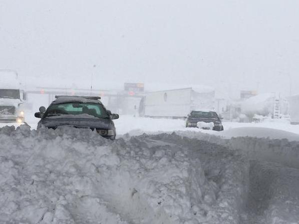
* photo above: New York State Police.
Climate Stories...
Tired Of The Cold Weather Already? Blame Global Warming. A
mental disconnect, counterintuitive? Absolutely, but changes in the
rate of warming of the Northern Hemisphere, especially what's happening
in the Arctic, may be impacting jet stream configurations, pulling more
bitter air south in the process - frigid air that's passing over Great
Lakes considerably warmer than they were 50 years ago. Here's an excerpt
from
BetaWired: "...
In
the case of this week’s massive snowfall in regions of upstate New York
like Buffalo, the principal scientist for NOAA’s National Climatic Data
Center, Thomas C. Peterson, said that the Great Lakes were too warm
when the Canadian air of the cold front hit it. The interaction with the
warm water and the frigid air created a massive “lake effect” storm
that positively inundated the region; while lake effect snow does impact
the area every winter, Peterson said that if the Great Lakes would have
been cooler the record snowfall wouldn’t have occurred. But where did
the cold polar air come from in the first place? Scientists say that
rising temperatures cause the jet stream to shift." (Photo: New York State Police)
There's Growing Evidence That Global Warming Is Driving Crazy Winters. Here's an excerpt of a story from Chris Mooney at
The Washington Post: "...
According
to Francis, the extreme U.S. winter of last year and now, the extremes
at the beginning of this season, fit her theory. "This winter looks a
whole lot like last winter, it’s a very amplified jet stream pattern,"
she says. "We know that when we get these patterns, it tends to be very
persistent. And it is definitely the type of pattern that we expect to
see more often as the Arctic continues to warm so fast." To be sure,
Francis acknowledges that our recent bout of extreme cold was
kickstarted most directly by Typhoon Nuri, which swerved up into the mid-latitudes and exploded into an atmospheric bomb over the Bering Sea..."
In Step To Lower Carbon Emissions, China Will Place a Limit on Coal use in 2020. While we "debate the science" China is taking action to lower their carbon emissions, which have now surpassed the USA's.
The New York Times has an article; here's the intro: "
China plans to set a cap on coal consumption in 2020, an important step for the country in trying to achieve a recently announced goal of having carbon dioxide emissions peak by around 2030. The State Council, China’s cabinet, released details of an energy strategy late Wednesday that
includes capping coal consumption at 4.2 billion tons in 2020 and
having coal be no more than 62 percent of the primary energy mix by that
year. Worldwide, coal burning for industrial use is the largest source
of carbon dioxide emissions, which are the biggest catalyst of global
climate change..."
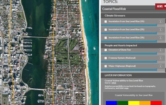
Will You Own Waterfront Property? Climate Change Website Has Answers.
You may want to pass this on to friends living on or near the water in
Naples, Fort Myers or Sarasota. Note to self: rent, don't own. Here's a
clip from
palmbeachpost.com: "
The White House has released a Climate Resilience Toolkit,
a web-based, interactive suite of maps, videos and data that allow
communities and businesses to confront their climate vulnerabilities and
build resilience. Among the tools is a mapping program that allows users to see how coastal communities will be affected by coastal erosion, storm surge and sea level rise..."
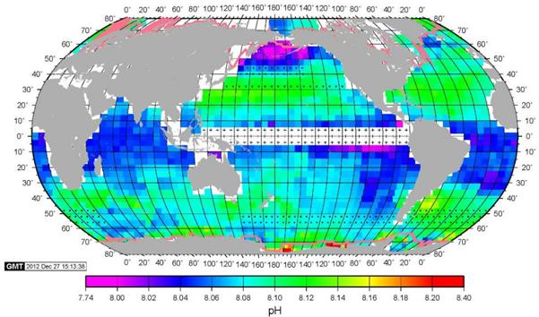
Acid Maps Reveal Worst of Climate Change.
The rapid warming and acidification of the world's oceans may be the
most underreported story out there right now - here's an excerpt of some
new research at
Scientific American: "...
The maps are an attempt to bring to visual life a problem that is just as invisible as the excess CO2 piling up in the atmosphere
for the past couple of centuries. People cannot see, taste or feel the
subtle shift in the seawater and it has taken years of measurement
around the world to gather enough data for this new global picture.
Calls for such measurements had been made since at least 1956..."
Image credit above: Courtesy of Columbia University's Lamont-Doherty Earth Observatory.
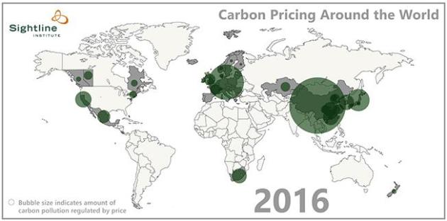
Within 2 Years a Quarter of The World's Carbon Emissions Are Likely To Be Priced. It's happening, slowly and piecemeal, but smart companies are already finding ways to price carbon. Here's a clip from
Grist: "...
It often surprises people to hear that big companies like Exxon use a “shadow carbon price”
when assessing future investment opportunities (in other words, they
assume a price on carbon even where/when there isn’t one). After all, if
you only pay attention to the headlines, it sounds like the big story
on climate change is that nobody’s doing anything and we’re all doomed.
Why would Exxon think carbon will be priced any time soon? Well, it
turns out that carbon is getting priced, not in the big, dramatic,
simple way climate hawks would prefer, but incrementally, piecemeal,
country-by-country, region-by-region, still inadequately but in a way
that’s starting to add up..."
Animation credit:
Sightline Institute
 Faith Groups Divided Over God's Role in Climate Change, Natural Disasters. The Washington Post
 has the story - here's a clip: "...
Americans largely concur that God created the Earth. But when it comes to how he wants its environment treated, and how much he’s willing to intercede — the agreement ends. A new poll released Friday
shows major differences between faith groups on topics including
concern over climate change, whether natural disasters are a sign of
biblical end times and how deeply connected they feel to nature..." (Image credit above: NASA).
* How
Nike is building climate change and weather extremes into marketing for it's new base-layer apparel.
House Republicans Just Passed a Bill Forbidding Scientists From Advising the EPA On Their Own Research. No, you just can't make this stuff up - here's the intro to a story at
Salon: "
Congressional climate wars were dominated Tuesday by the U.S. Senate, which spent the day debating, and ultimately failing to pass,
a bill approving the construction of the Keystone XL pipeline. While
all that was happening, and largely unnoticed, the House was busy doing
what it does best: attacking science. H.R. 1422, which passed 229-191,
would shake up the EPA’s Scientific Advisory Board, placing
restrictions on those pesky scientists and creating room for experts
with overt financial ties to the industries affected by EPA regulations..."
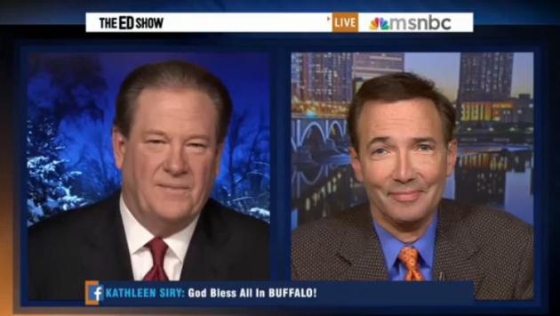
Did Climate Change "Juice" The Buffalo Snow Amounts?
Water temperatures in Lake Erie were in the low to mid 50s earlier this
week, almost 50F warmer than the air passing overhead. There's
considerable evidence that warmer water in the Great Lakes is resulting
in more extreme lake effect snow events earlier in the season than 30-50
years ago. What influence did climate volatility play in the
(incredible) snowfall amounts and snowfall rates since Tuesday. I had a
chance to chat with Ed Schultz at MSNBC Thursday; the clip is
here.
There's Growing Evidence That Global Warming Is Driving Crazy Winters. Here's an excerpt of a story from Chris Mooney at
The Washington Post: "...
According
to Francis, the extreme U.S. winter of last year and now, the extremes
at the beginning of this season, fit her theory. "This winter looks a
whole lot like last winter, it’s a very amplified jet stream pattern,"
she says. "We know that when we get these patterns, it tends to be very
persistent. And it is definitely the type of pattern that we expect to
see more often as the Arctic continues to warm so fast." To be sure,
Francis acknowledges that our recent bout of extreme cold was
kickstarted most directly by Typhoon Nuri, which swerved up into the mid-latitudes and exploded into an atmospheric bomb over the Bering Sea..."
 Unraveling The Mysteries of Deadly "Firehose" Lake Effect Snow Events.
Every lake effect snow event is different, but what are the ingredients
that go into historic snowfalls? Are lake effect snows downwind of Erie
and Ontario some of the heaviest on earth? Andrew Freedman has a
fascinating story at Mashable; here's an excerpt: "...Jim
Steenburgh, a meteorology professor at the University of Utah, said the
Buffalo storm's first round confirms some of what he and his colleagues
observed in high-resolution last year. These storms can have a
“structure that’s really incredible… a structure that you sometimes see
with severe thunderstorms,” he told Mashable. From Tuesday through
Wednesday, the narrow band of heavy snow that targeted towns such as
West Seneca, New York, on Tuesday night, was barely 15 miles wide but
more than 100 miles long. In chilling photographs, it resembled a wall
of snow more closely akin to a broiling dust storm than a snow squall..."


.jpg)

No comments:
Post a Comment