51 F. high in the Twin Cities Sunday.
55 F. record high for November 23 (1905).
37 F. average high on November 23.
19 F. high on November 23, 2013.
Trace of snow left on the ground at MSP International Airport.
November 23 in Minnesota Weather History. Source: Twin Cities National Weather Service:
1993:
The Thanksgiving Day Blizzard of 1993. Central and Western to South
Central Minnesota were affected by a slow moving storm system that
traveled across the upper midwest during the Thanksgiving holiday
causing heavy snow across most of Minnesota. Travel became extremely
difficult if not impossible over west central Minnesota where over a
foot of snow accumulated. A number of car accidents were reported and
several community events were canceled. Snowfall in excess of six inchs
or greater occurred north of a line from Bricelyn (Faribault County) to
the Twin Cities. Counties affected by this storm include Anoka, Benton,
Blue Earth, Brown, Chippewa, Chisago, Douglas, Faribault, Hennepin,
Isanti, Kanabec, Kandiyohi, Lac Qui Parle, Martin, Mcleod, Meeker, Mille
Lacs, Morrison, Nicollet, Pine, Pope, Ramsey, Redwood, Renville, Rock,
Sherburne, Sibley, Stearns, Stevens, Swift, Todd, Washington, Watonwan,
Wright, and Yellow Medicine.
1983: Snowstorm dumps almost two feet at Babbitt and about 20 inches at Duluth.
1825: Warm spell begins over Ft. Snelling, Temperature rises up to 70 degrees over the week.
Cold Comfort
There
are few other places on the planet where locals "thank" a meteorologist
for 50 degrees. It's been too cold, too early. "Paul, if it's like this
in November, what will January be like?" Cold, with some snow. Just a
gut feeling.
If it was a sticky 85 degrees year-round I'd have
motion sickness from swaying in a hammock, lost in a Corona-coma. I'd
get nothing done.
Bracing slaps of wind chill focus our ingenuity,
forcing us to engineer new ways to keep out the pain. We survive. We
thrive. And no Minnesotan I've ever met takes a warm front for granted.
Here's
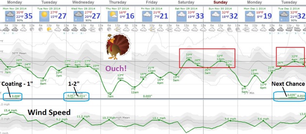
what I know: the next 2 weeks won't be as cold as the previous 2 weeks.
A coating of snow is possible today as winds blow from Canada; another
inch or two of slush Wednesday. The pattern isn't ripe for
headline-grabbing snow storms thru the second week of December.
I
see a subtle shift in the pattern, possibly a symptom of a brewing El
Nino. Rain is finally reaching California, and a slightly milder, zonal,
Pacific wind flow will thaw us out from time to time, as early as next
weekend.
Climate volatility is real; the swings are getting more
severe. Buffalo's suburbs go from 8 feet of snow to 60F and flooding
today.
An Early Nap?
Thanksgiving is Thursday (as if you could possibly forget that fact)
and after gazing at the maps I'm already getting a little sleepy. No
major storms are brewing this week, maybe a coating to an inch today
(more over Wisconsin), another inch or two Wednesday, possibly some
accumulation by Tuesday of next week. Thursday appears to be the coldest
day in sight with highs holding in the teens, but European data is
hinting at another thaw next weekend.
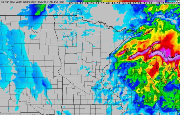
60-Hour Snowfall Potential.
NOAA NAM data shows some 8-15" amounts just downwind of Lake Superior
into early Wednesday, but plowable amounts of snow are possible from
near Rhinelander and Green Bay to Oshkosh. If your travels take you east
snow amounts will gradually increase as you approach Lake Michigan.
Source: HAMweather.
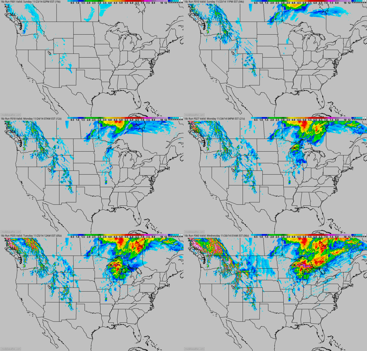
Close Call.
A storm winding up over the Great Lakes will inhale enough Canadian air
to change rain over to snow across Wisconsin and the U.P. of Michigan.
More snow accumulates from near Denver to Boise; a series of Pacific
storm delivering some badly needed rain to drought-stricken California
this week. It looks like the El Nino signal is finally kicking in,
pushing the storm track farther south over the western USA.
December Temperature Spike?
I'm not buying it, not yet, but the GEFS model is hinting at 50F in the
Twin Cities on December 3. It's still a long way out; 40s seem more
plausible in early December as Pacific air pushes east of the Rockies.
Not sure about 50F, but we are due for the weather pendulum to swing in
the other direction. Chart: Aeris Enterprise from HAMweather.
Winter Weather Weirdness May Be Just Beginning.
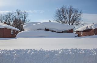
The Buffalo News, where they know a thing or two about odd weather, has the story - here's an excerpt: "...
Meteorologists
and geographers say that lake-effect snows have increased as
temperatures have warmed in recent decades. That means more bizarre
early-season storms, though not necessarily as bad as last week’s, are
likely in the future as the warming trend continues. “The general notion
is that, as the climate warms and the lakes hold their warmth longer
into the fall, you’re going to see a lot more lake-effect snow until
it’s too warm to have much snow,” said Mark Monmonier, distinguished
professor of geography at Syracuse University and the author of the 2012
book “Lake Effect: Tales of Large Lakes, Arctic Winds, and Recurrent
Snows...”
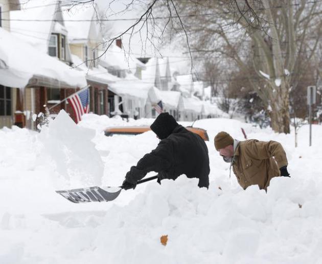
Photo credit above: "
Mark Petrik and
Dennis Smith dig out their south Buffalo driveway on Saturday, Nov. 22,
2014, in Buffalo, N.Y. Western New York continues to dig out from the
heavy snow dropped by this week by lake-effect snowstorms." (AP Photo/Mike Groll).
Snowed Under and Frozen Over: U.S. Weather Is Off The Rails, But Why?
The jet stream is "drunk" once again - memories of last winter have
emerged much sooner than anyone wanted or expected. Will it continue,
and how is a rapidly warming Arctic impacting prevailing steering winds?
Here's an excerpt of an explanation at
Capital Weather Gang: "...
Last
summer we saw the 6th lowest sea-ice minimum extent, and the extremely
warm temperatures now over the Arctic are from all the extra heat
absorbed by the Arctic Ocean where ice was lost,” Francis said. “When
the Arctic is so warm, the west winds of the jet stream weaken, and this
favors the highly wavy pattern to the jet stream responsible for this
early winter chill in the eastern U.S as well as the continued drought
and heat in California....”
The Real Roots of Midlife Crisis.
I challenge anyone in their 40s or 50s to (honestly) admit that they
haven't had a similar experience. The U-Curve is real, it turns out, and
no, you're not alone.
The Atlantic has a very worthy read - here's a snippet: "...
Long
ago, when I was 30 and he was 66, the late Donald Richie, the greatest
writer I have known, told me: “Midlife crisis begins sometime in your
40s, when you look at your life and think, Is this all? And it ends
about 10 years later, when you look at your life again and think,
Actually, this is pretty good.” In my 50s, thinking back, his words
strike me as exactly right..." (Photo credit: Chris Buck).
TODAY: Gusty winds, turning colder. Coating of light snow. Winds: NW 15-30. High: 25
MONDAY NIGHT: Flurries taper, partial clearing. Low: 14
TUESDAY: Sun returns, doesn't help much. High: 28
WEDNESDAY: Inch or 2 of slush? Slick spots. Wake-up: 23. High: 28
THANKSGIVING: Cold sun. Food coma likely. Wake-up: 6. High: 17
BLACK FRIDAY: Chance of a snowy coating. Wake-up: 15. High: 29
SATURDAY: Mostly cloudy, thawing out a bit. Wake-up: 21. High: 33
SUNDAY: Mostly cloudy, no travel headaches. Wake-up: 26. High: 32
Climate Stories...
Expect More Giant Snowstorms As Climate Warms. A
warmer atmosphere contains more water vapor, loading the dice in favor
of not only heavier summer rains, but more extreme winter snows - until
temperatures become too warm for snow.
LiveScience has the story; here's an excerpt of the article, including a quote from Penn State climate scientist Michael Mann: "...
Part
of what gave us the record lake-effect snowfall in Buffalo was warm,
late-fall lake-surface temperatures that combined with something highly
unusual: a 5 sigma event. That is, a very unlikely event on the order of
1-in-a-million — a remarkably persistent, anomalous configuration of
the jet stream, which brought frigid Arctic air down into the United
States so early in the season," said Michael Mann, professor and
director of the Earth System Science Center at Pennsylvania State
University. "The cold winds traveling over the warm moisture-laden lake
created a perfect storm of conditions for record lake-effect snow..."
Global Warming: Extreme Weather Will Be The "New Climate Normal", World Bank Warns.
International Business Times has the article - here are a few clips that got my attention: "
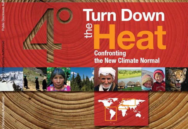
The World Bank Sunday warned extreme weather will become the "new climate normal," increasing the risk of world instability. The report, "Turn Down the Heat: Confronting the New Climate Normal,"
analyzes the impact of warming of 2 to 4 degrees Celsius (3.6 and 7.2
degrees Fahrenheit) above pre-industrial levels on crops and
coastlines....Extreme heat is the biggest problem, the report found,
because it can reduce crop yields, negatively impacting food security
and future economic growth as well as economic development, social
stability and well-being..."
* the 320 page PDF "Turn Down The Heat: Confronting the New Climate Normal" from The World Bank is
here.
New Study: Major Investors Worried About Companies' Readiness for Climate Change. Wall
Street, increasingly, is paying attention. Liability is growing -
companies realize they have risk. The smart ones will ignore science
deniers and take steps to lower long term threats to their business
models (and share price). Here's the intro to a story at
Forbes: "
A new study
from a significant source shows that a majority of large investors are
worried about companies’ readiness for climate change. The source is
significant in that this information isn’t just the data, say, of a
fringe environmental group – it’s asset managers and pension fund
managers responsible for a total of more than $11 trillion..."
Image credit: National Science Foundation.
Climate Change Threatens To Strip The Identity Of Glacier National Park.
What will they call it when the glaciers are gone? Glaciers, along with
sea level rise, are a good proxy for long-term climate trends. Here's
an excerpt from
The New York Times: "...
A
century ago, this sweep of mountains on the Canadian border boasted
some 150 ice sheets, many of them scores of feet thick, plastered across
summits and tucked into rocky fissures high above parabolic valleys.
Today, perhaps 25 survive. In 30 years, there may be none. A warming climate is melting Glacier’s glaciers, an icy retreat that promises to change not just tourists’ vistas, but also the mountains and everything around them..."
Half of Americans Think Climate Change is a Sign Of The Apocalypse.
The Atlantic has the article - here's an excerpt: "
Snowmageddon, snowpocalypse, snowzilla, just snow. Superstorm Sandy, receding shorelines, and more.
Hurricanes Isaac, Ivan, and Irene, with cousins Rammasun, Bopha, and
Haiyan. The parade of geological changes and extreme weather events
around the world since 2011 has been stunning. Perhaps that's part of
why, as the Public Religion Research Institute reported
on Friday, "The number of Americans who believe that natural disasters
are evidence of the apocalypse has increased somewhat over the past
couple years..."





No comments:
Post a Comment