30 F. high in the Twin Cities Thursday.
28 F. average high on December 11.
5 F. high on December 11, 2013.
2004:
A strong cold front pushed through Minnesota during the early morning
hours. By dawn, winds turned to the northwest and increased to 25 to 40
MPH with gusts as high as 70 MPH. The windiest part of the day was from
mid morning through mid afternoon when many locations suffered sustained
winds in the 30 to 45 MPH range. The highest wind gusts recorded in
southern Minnesota during this time included 71 MPH in Welch and 62 MPH
near Albert Lea, St. James, Winthrop and Owatonna. Other notable wind
gusts included 59 MPH at New Ulm, 58 MPH in Mankato, 55 MPH in St. Cloud
and Morris, 54 MPH at Redwood Falls, and 52 MPH at the Minneapolis/St.
Paul International Airport. Scattered trees were downed and a few
buildings received minor roof damage across the region.
1939: December gale at north shore; winds clocked at 48 mph at Duluth. Source: MPX National Weather Service.
The Dark Side
"The
sun that brief December day, rose cheerless over hills of gray..."
Those are John Greenleaf Whittier's opening lines to "Snowbound" and
they pretty well nail the meteorological malaise that descends on
Minnesota during December.
Most of us can handle brittle wind
chills, even the endless snow cones of grit. It's the darkness that
throws many into a dark funk. December is the
cloudiest month of the year, on average.
My
friend and consulting meteorologist Dean DeHarpporte just cheered me up
with this nugget: December 10 is the day the sun sets earliest (4:32
PM) of any day of the year. "The 23.4 degree tilt of the earth's axis
and the varying speed of the earth in its orbit around the sun combine
to make the earliest sunset before the 21st in December" he wrote.
December 21 is the shortest day, but we've already had our earliest
sunset. It's all uphill from here!
Yep, it's a big hill.
Unseasonably
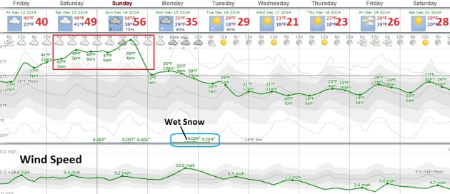
mild air chilled from below sparks lazy clouds (fog) into the weekend.
40s are expected; 30F warmer than mid-December 2013. It should feel like
a bad Club Med vacation.
Rain ends as wet snow Monday but I still don't see any major snowfalls between now and Santa's grand entrance.
 Mild Spell
.
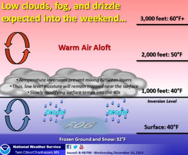
I'm not convinced we'll see 50s in the Twin Cities with the sharp
inversion hovering overhead, temperatures 20-30 degrees warmer some
3,000 to 4,000 feet above the ground, putting a lid on clouds, fog and
pollutants. But we'll see 40s, which will feel like a minor miracle, and
the arrival of colder air sets off a period of wet snow. A slushy
accumulation is possible by Monday night - too early for details. We
cool off next week, but nothing frigid is brewing, and I still don't see
big storms between now and Christmas.
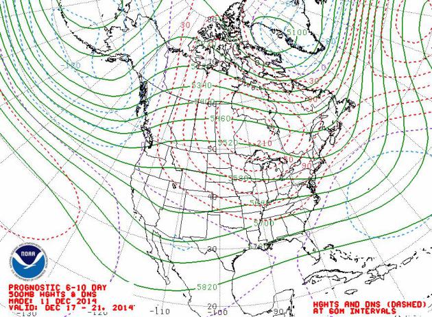
 Prevailing Jet Stream Winds: December 17-21
.
NOAA guidance continues to show a modified zonal flow, winds aloft
still blowing from the Pacific, which will limit just how cold it can
get between now and roughly Christmas. Most of the big California storms
will track well south of Minnesota, dumping heavy rain on Dallas and
Atlanta.
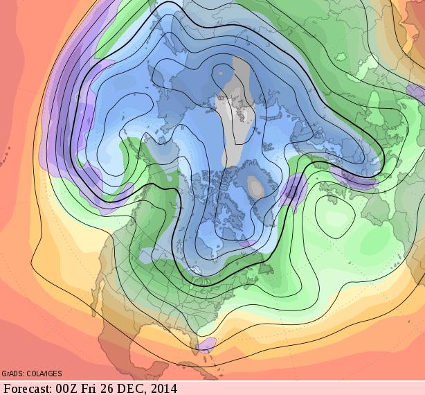
 Cooling Trend After Christmas
.
Long-range GFS guidance from GrADS COLA/IGES shows a more amplified
pattern returning the last week of December, capable of cooling us down
into the teens and 20s for highs. As long as it stays above zero any
complaints will probably be muted. Nothing frigid or subzero is on the
horizon, not yet.
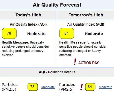
Air Quality Advisory In Effect.
This nagging inversion (warm air aloft, colder air near the ground,
with little mixing of the atmosphere) is trapping particulant pollution
within a few hundred feet of ground-level, increasing the risk to
specific groups: athletes exercising outside, the elderly and people
with heart and respiratory issues are most likely to be impacted. Here's
more information from
AirNow: "
An
Air Quality Advisory is in effect for Minneapolis-St. Paul for Friday
and Saturday. Today, moisture associated with fog and mist is enhancing
particle formation in eastern Minnesota. Furthermore, light southerly
winds will transport additional pollutants into the Twin Cities,
resulting in mid-Moderate AQI levels. Tomorrow and Saturday, high
relative humidity associated with fog and mist will continue to support
particle formation, and an upper-level ridge of high pressure building
over Minnesota will reduce vertical mixing, trapping pollutants near the
ground. In addition, light to moderate southerly winds ahead of an
approaching cold front will bring additional pollutants into
Minneapolis-St. Paul. Therefore, AQI levels will be upper Moderate on
both days, with hourly AQI levels reaching Unhealthy for Sensitive
Groups at times. Sunday, as the cold front moves through Minnesota late
in the day, enhanced atmospheric mixing and moderate west-northwesterly
winds behind the front will help to disperse pollutants in the Twin
Cities..."
* Fine particles may exacerbate pre-existing
health conditions and may cause individuals to experience chest pain,
shortness of breath, wheezing, coughing of fatigue. If you experience
these symptoms, contact your physician. Source: EPA's AirNow.
An Aversion to Inversions.
Temperatures in the atmosphere usually cool with height; the higher up
you go the colder it gets, until you get to the stratosphere, but that's
a different story. This weekend temperatures a few thousand feet above
the ground will be in the 50s, but most of that warmth won't be able to
mix down to the surface, due to lingering snow cover and cold ground
chilling the air from below. That said, 40s should feel pretty good.
More details from the
Twin Cities National Weather Service.
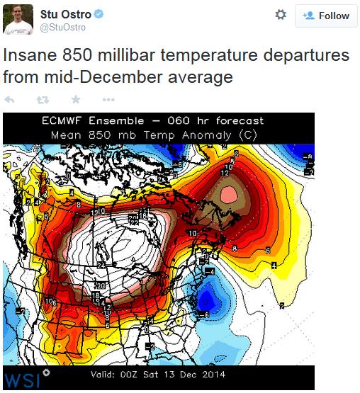
Crazy Temperature Anomalies. Meteorologist Stu Ostro at The Weather Channel posted this
tweet, showing 850 mb temperature anomalies this evening - keep in mind these anomalies are in Celsius.
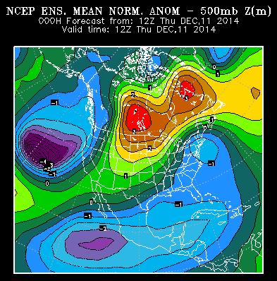
Another Hyper-Rare 5 Sigma Weather Event?
Some of the online chatter from climate scientists I know and trust
point to the strength of the high pressure ridge centered over central
Canada; nearly 5 standard deviations from the mean, which is quite
extraordinary. The same storm that steam-rolled into California with
flooding and high winds helped to carve out this massive warm weather
bubble, and a weather map that, temporarily at least, looks more like
late March than mid-December.
Equation of Time.
Light reading this is not. Here's a snippet of a long, math-filled
explanation of why December 10 had the earliest sunset, not the 21st
(among other oddities related to the Earth's elliptical orbit and
changes in forward speed around the sun, courtesy of
Wikipedia: "...
The
Earth revolves around the Sun. As seen from Earth, the Sun appears to
revolve once around the Earth through the background stars in one year.
If the Earth orbited the Sun with a constant speed, in a circular orbit
in a plane perpendicular to the Earth's axis, then the Sun would culminate
every day at exactly the same time, and be a perfect time keeper
(except for the very small effect of the slowing rotation of the Earth).
But the orbit of the Earth is an ellipse not centered on the Sun, and
its speed varies between 30.287 and 29.291 km/s, according to Kepler's laws of planetary motion, and its angular speed also varies, and thus the Sun appears to move faster (relative to the background stars) at perihelion (currently around 3 January) and slower at aphelion a half year later..."
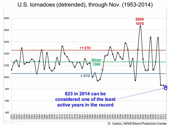
2014: One Of The Least Active Tornado Years On Record For The USA. Here's an excerpt of a story at
The Washington Post: "...
At
least 400 fewer tornadoes than average have touched down in the U.S.
this year, making it one of the quietest years on record for twisters,
according to the National Weather Service (NWS). Whereas an average of
1,260 tornadoes form each year in records dating to the early 1950s,
only 823 have occurred in 2014 through November, says Greg Carbin,
warning coordination meteorologist at the NWS Storm Prediction Center,
in Norman, Okla..."
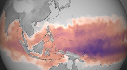
Warm Ocean Waters Boosting Typhoons, Record Heat. The Atlantic was relatively quiet (again), but the Pacific was anything but, as highlighted in this excerpt from
Climate Central: "...
Also
rare for the Atlantic would be the five Category 5-strength storms that
have spun up in the West Pacific this year, the most in that basin
since the 10 seen in 1997, according to Steven Bowen, an associate
director and meteorologist with the reinsurance group Aon Benfield.
The record for Category 5 storms in a single season in the Atlantic is
only four, which has only happened once, during the blockbuster 2005
season. The West Pacific, on the other hand, has averaged about three
Category 5 storms a season since 2000, Bowen said. The five storms this
season have still been noteworthy, and one reason there have been so
many are the warm waters that have been in place across the Pacific. The
waters that allowed Hagupit to rapidly strengthen last week were about
2°F warmer now than this time last year, Bowen said..."
Map credit above:
"Graphic
showing the total amount of heat energy available for Super Typhoon
Haiyan to absorb, not just on the surface, but integrated through the
water column. Deeper, warmer pools of water are colored purple, though
any region colored from pink to purple has sufficient energy to fuel
storm intensification. The dotted line represents the best-track and
forecast data as of 16:00 UTC on Nov. 7." Courtesy of NOAA.
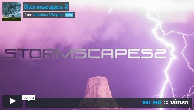
Photographer's Awe-Inspiring Video Shows Severe Weather In A New Light.
I've seen a lot of spectacular storm video, but this is still some of
the best HD time-lapse footage I've ever seen. Check out details and a
link to the clip at
Yahoo News: "
A photographer and storm chaser who produced a mesmerizing time-lapse video of thunderstorms and supercells swirling in the northern Great Plains last year
is back with another awe-inspiring film. Nicolaus Wegner, a 34-year-old
from Casper, Wyoming, spent May through September shooting all sorts of
severe weather in Wyoming, Montana, South Dakota, Nebraska, and
Colorado. The resulting 7-minute film, "Stormscapes 2," captures
tornadoes, double rainbows, mesocyclones, lightning, and rare cloud
formations in stunning HD clarity — all perfectly set to sweeping, dramatic electronic music..."
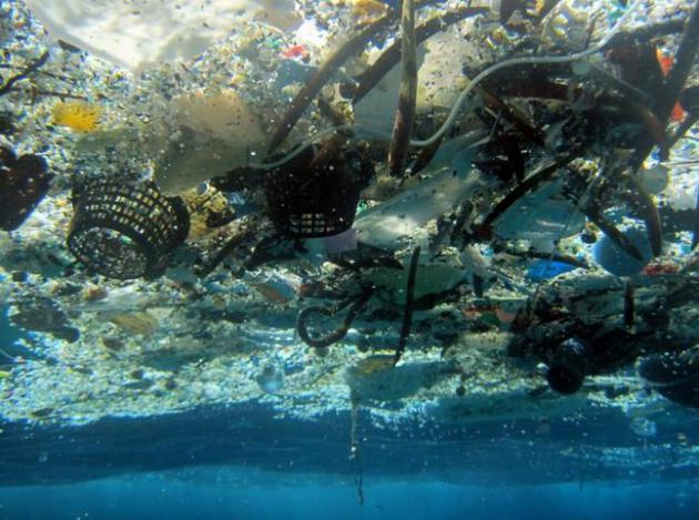
Study Shows That 270,000 Tons of Plastic Float In The Oceans. Here's the intro to a troubling story from AP and
Huffington Post: "
A
new study estimates nearly 270,000 tons of plastic is floating in the
world's oceans. That's enough to fill more than 38,500 garbage trucks.
The plastic is broken up into more than 5 trillion pieces, said the
study published Wednesday in the scientific journal PLOS ONE..."
File photo credit above: "
This
file 2008 photo provided by NOAA Pacific Islands Fisheries Science
Center shows debris in Hanauma Bay, Hawaii. A new study estimates nearly
270,000 tons of plastic is floating in the world's oceans. That's
enough to fill more than 38,500 garbage trucks if each truck carries 7
tons of plastic. The figure appears in a study published, Wednesday,
Dec. 10, 2014, in the scientific journal PLOS ONE. Researchers say the
plastic is broken up into more than 5 trillion pieces." (AP Photo/NOAA Pacific Islands Fisheries Science Center, File).
New Poll Shows Widespread, Bipartisan Support for Stronger Methane Standards, More Clean Air Protections. Here's an excerpt of some intriguing poll results from
The American Lung Association: "...
Key poll findings include:
- The
majority of voters, 63 percent, support standards for methane
emissions. After hearing a balanced debate on both sides, support
increases overall to 66 percent. In particular, Republicans moved from
45 percent supporting to 53 percent supporting.
- EPA remains much more popular than Congress.
- The EPA continues to earn positive favorability ratings, at 42 percent favorable compared to 31 percent unfavorable.
- Voters'
feeling toward Congress remains strongly negative with 60 percent
giving it an unfavorable rating, a trend that crosses party lines..."
The Era Of Our Discontent. Do you (do we) suffer from "Weltschmerz"? Check out an article at
Pacific Standard; here's a snippet: "...
But
American Weltschmerz has extended far beyond millennials. It has become
the dominant zeitgeist. The country is currently experiencing social,
economic, and technological “disruption” similar to what sparked the
19th-century Romantic backlash—and its later incarnations. The Romantic
era emerged out of disillusionment of the initial wave of the Industrial
Revolution..."
U.S. Navy Successfully Deploys Laser Weapon. Cue Buck Rogers - this reads like something out of a Star Wars episode. Here's an excerpt from
Gizmag: "
The
laser goes from the weapon of tomorrow to the weapon of today as the US
Navy announces the completion of its successful deployment of the
Office of Naval Research's (ONR) Laser Weapon System (LaWS).
The deployment is the first on a US Naval vessel and took place on the
USS Ponce (LPD-15) in the Arabian Gulf from September to November of
this year..."
Craft Beers on Select Delta Flights? Another sign of the pending Apocalypse. HuffPo has
details.

TODAY: Cloudy, foggy and milder. Winds: South 10. High: 39
FRIDAY NIGHT: More fog, quite dense in some areas. Low: 38
SATURDAY: Still gray. Thick fog, March-like temperatures. High: 46
SUNDAY: Fog and drizzle, still mild. Wake-up: 37. High: 48
MONDAY: Cold rain ends as wet snow. Late PM slush? Wake-up: 32. High: 36
TUESDAY: Flurries taper. Mostly cloudy skies. Wake-up: 25. High: 29
WEDNESDAY: More sun, chilly and dry. Wake-up: 19. High: 26
THURSDAY: Patchy clouds, light winds. Wake-up: 16. High: 28
Climate Stories....
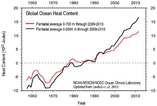
Global Warming Continues, Despite Continuous Denial. St. Thomas climate scientist Dr. John Abraham has the story at
The Guardian; here's a clip: "...
First,
there has been no pause or even slowdown in the warming of the planet.
We provide updated information from NOAA which clearly shows a continued heating of the world’s oceans
– the reservoir where most heat ends up. We compare energy contained in
different layers and discuss the transfer of energy from the surface
regions to the lower regions. When you look at the oceans, the so-called
pause is simply a redistribution, a burying of heat to deeper waters..."
Graphic credit above: "
Ocean heating data from the National Oceanic and Atmospheric Administration."
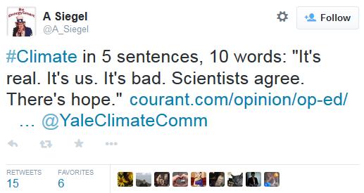
 The Great Climate Change Denial Industry.
Why? Because trillions of dollars are on the line. This is an
existential threat for the fossil fuel industry. When in doubt - follow
the money. Here's an excerpt from a story at The Hartford Courant: "...With
respect to "it's real," geologists have shown that climate change,
rather than stability, is the long-term default condition. Knowing that
"it's us" requires understanding how the earth carbon budget works as a
coherent system. Knowing that "it's bad" requires looking back in time
to former conditions reconstructed from the rock record. Knowing that
"there's hope" requires nothing more than learning that Earth is not the
fragile planet we've been led to imagine. Rather, it's tough and
resistant to anything climate change can throw at it. It's humanity that
is vulnerable
The Great Climate Change Denial Industry.
Why? Because trillions of dollars are on the line. This is an
existential threat for the fossil fuel industry. When in doubt - follow
the money. Here's an excerpt from a story at The Hartford Courant: "...With
respect to "it's real," geologists have shown that climate change,
rather than stability, is the long-term default condition. Knowing that
"it's us" requires understanding how the earth carbon budget works as a
coherent system. Knowing that "it's bad" requires looking back in time
to former conditions reconstructed from the rock record. Knowing that
"there's hope" requires nothing more than learning that Earth is not the
fragile planet we've been led to imagine. Rather, it's tough and
resistant to anything climate change can throw at it. It's humanity that
is vulnerable..."
Climate Change Isn't Just Impacting Crops; It's Taking a Physical and Psychological Toll on Farmers.
Is a more volatile climate, with more extreme swings in day to day
weather really increasing anxiety levels in the ag community or has it
always been like this? Here's an excerpt of a story at
Medical Daily that's worth a read: "...
Like
Finnerty, all types of farmers are affected by climate change. For
example, produce farmers are constantly rearranging their planting
schedules, while livestock and dairy farmers worry about the quality of
feed available to their animals. Matthew Russell, a fifth generation
Iowa farmer says the past 10 years has made farm life a more anxious
environment, as he is constantly concerned over the little time he has
to address the changing conditions and its impact on the timing and
quality of growing and harvesting seasons. “Psychologically, in the last
fews years, there’s a lot of anxiety that I don’t remember having 10
years ago,” Russell told Medical Daily..."
Photo credit: Tim McCabe, USDA.
Why Free Marketeers Don't Buy Climate Science.
The cure is worse than the disease! Really? Why not let markets come up
with solutions, but for that to work there needs to be a legitimate
signal in the marketplace, a price for carbon pollution, and then the
markets will come up with the innovations and solutions required to
mitigate this problem. Cass Sunstein has an interesting Op-Ed at
Bloomberg View; here are two brief clips: "...
It
is often said that people who don't want to solve the problem of
climate change reject the underlying science, and hence don't think
there's any problem to solve. But consider a different possibility:
Because they reject the proposed solution, they dismiss the science. If
this is right, our whole picture of the politics of climate change is
off...Troy Campbell and Aaron Kay of Duke University's business school
call this phenomenon “solution aversion.” And they have found compelling
evidence for it in the context of climate change..."
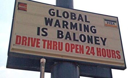
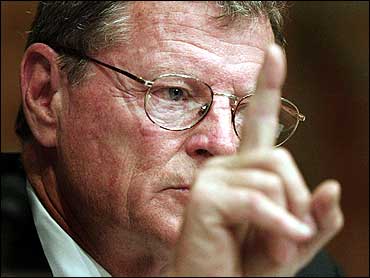
James Inhofe Is Not a "Climate Skeptic". Here's a clip from a story at
National Journal: "
How
should reporters write about lawmakers and others who dispute the
scientific consensus that climate change is largely driven by humans? A
group of 48 scientists, science writers, and other experts—including
popular educator Bill Nye—have some strong views on the subject. The
group issued a statement
last week taking the media to task for using the phrase "climate
skeptic," saying that the word "denier" is more accurate. In the
statement, the Committee for Skeptical Inquiry disapprovingly cites a
November New York Times piece that described GOP Sen. James Inhofe, who calls global warming a "hoax," as a "prominent skeptic of climate change..."
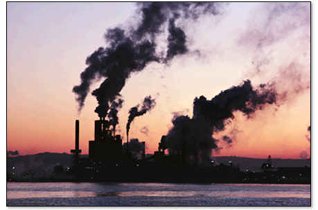
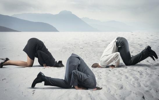
Top Scientists To Media: Stop Using "Skeptic" To Describe Climate Science Deniers. Following up on the story above here's a clip of Joe Romm's take at ThinkProgress: "...
Proper
skepticism promotes scientific inquiry, critical investigation, and the
use of reason in examining controversial and extraordinary claims,” the
letter reads. “It is foundational to the scientific method. Denial, on
the other hand, is the a priori rejection of ideas without objective
consideration...” (Image above: Shutterstock).




No comments:
Post a Comment