25 F. average high on December 21.
23 F. high on December 21, 2013.
.15" rain fell yesterday in the Twin Cities.
.1" snow fell.
December 21, 2000: A chilly day in Minnesota, with a high of zero degrees in Minneapolis, and a low of 14 below.

The Greatest Gift
"You don’t choose your family. They are God’s gift to you, as you are to them" wrote Desmond Tutu.
When your kids are young you teach them; when they get older they teach you. My oldest son is a digital marketing specialist and musician, playing lead guitar for "The Lost Wheels". The other day he said something profound. "Things are a poor substitute" he said. "The best gift you can give is your time. They're not making any more of that."
I hope you spend time with the people you care about in the coming weeks. Amazingly, the weather won't be a show-stopper, at least not close to home.
It's disorienting waking up to rain and green lawns the day after the Winter Solstice, but a changeover to wet snow may leave behind a couple inches of snow on lawns and fields Tuesday - most roads wet & slushy with temperatures near 32F. Expect low 30s and a dry sky for Christmas; a storm passing south of Minnesota pulls in colder air this weekend with highs stuck in the teens. A second, colde smack arrives around New Year's with a couple nights near zero.
Long-range guidance shows a rapid temperature recovery the first week of 2015, a January thaw possible the second week of the New Year.
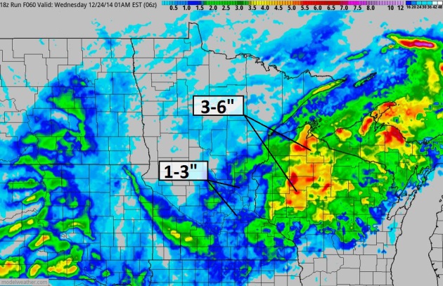
Slushy Tuesday.
Temperatures aloft are just warm enough for mostly rain and drizzle
today with temperatures in the mid to upper 30s, but the entire column
of atmosphere slowly cools tonight into tomorrow, with rain ending as a
couple inches of slushy snow on lawns and fields, while most roads may
stay wet into much of Tuesday. 60-hour NAM accumulated snowfall: NOAA
and HAMweather.
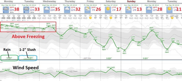
Relatively Mild Into Christmas Day.
Colder air arrives by late week and next weekend, but the next 48-72
hours will be milder than average with 30s spilling over into Christmas
Day. Rain today ends as an inch or two of snow tomorrow, maybe more
north/east of MSP into western Wisconsin. By Saturday there will be no
doubt in your mind that it's late December.
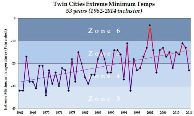
Coldest Winter Temperatures Since 1962 at KMSP. Investment banker and serious rose enthusiast
Jack Falker sent me this graph showing the coldest nighttime minimum
temperatures for every winter season dating back to 1962. Nature never
moves in a straight line, but the trend is upward over time.
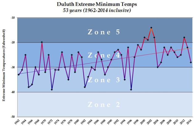
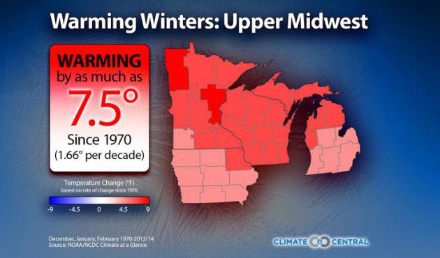
Duluth Trends.
Average (coldest) minimum temperatures have warmed about 9F at Duluth
Since 1962. It's more than urban heat island, as other reporting
stations well outside warmer metropolitan areas are showing the same
trends in recent decades. Graphic credit: Jack Falker.
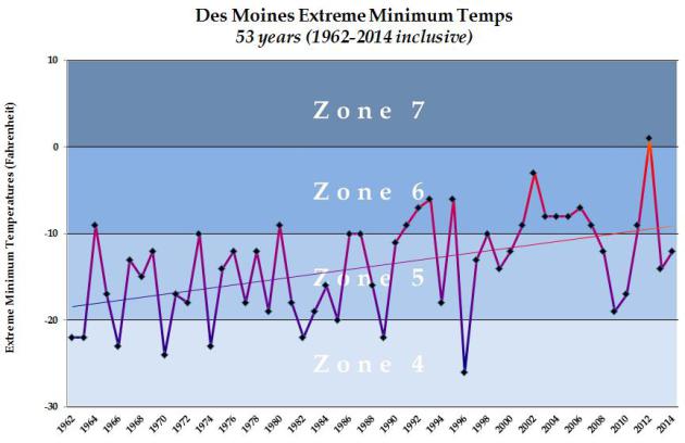
Des Moines Trends.
The slope of the line is steeper at more northerly latitudes (which
climate models predicted 30 years ago, the result of positive feedback
loops) but the same slow warming trend is on display at Des Moines.
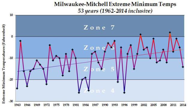
Milwaukee Trends.
You may not believe it if you make a habit of watching the Packers play
in Green Bay, but Wisconsin cities are showing the same trends over
time. It's not a hoax or a conspiracy, it's data, and it shows
conclusively and definitively that it's just not getting as cold as it
did 30-40 years ago. There will be exceptions to every rule, but the
trends are undeniable.
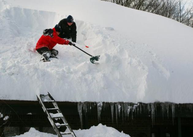
File photo credit: Mike Mulville, Buffalo News, AP.
.jpg)
The Body Electric. What's it like to be struck by lightning? Trust me, you don't want to know. Outside Magazine has an excellent article that documents what happens to your body and how doctors are still baffled by some of the long-term afflictions of lightning strike survivors. Here's an overview: "Every year, more than 500 Americans will be struck by lightning—and roughly 90 percent of them will survive. Though they remain among the living, their minds and bodies will be instantly, fundamentally altered in ways that still leave scientists scratching their heads."


TODAY: Periods of rain and drizzle. Wet roads. Winds: SE 10-15. High: 38
MONDAY NIGHT: Rain mixes with wet snow; slushy by morning. Low: 33
TUESDAY: Slushy snow, couple inches possible. High: 34
CHRISTMAS EVE: Peeks of sun, better travel conditions. Wake-up: 30. High: 33
CHRISTMAS DAY: Mostly cloudy, still above average. Wakeup: 23. High: 32
FRIDAY: AM snow south, colder wind. Wake-up: 20. High: 26
SATURDAY: Numbing with flurries. Wind chill: -5. Wake-up: 4. High: 14
SUNDAY: Some sun, feels like December. Wake-up: 2. High: 15
Climate Stories...
No comments:
Post a Comment