6 F. high in the Twin Cities Monday.
32 F. average high on December 1.
34 F. high on December 1, 2013.
68 F. record high for December 1 (1998).
December 1, 1985:
Record low highs were set in north and east central Minnesota with
temperatures ranging from the single digits below zero to the singles
digits above. Alexandria was the cold spot with a high of 4 degrees
Fahrenheit below zero. Other low high temperatures included Redwood
Falls with 3 below, Long Prairie with zero, and Litchfield and Little
Falls with 5 degrees above zero.
December 1, 1982: Warm up over Southern Minnesota. Record high of 63 degrees at Twin Cities.
Tundra Tales
The
weather rhymes but it rarely repeats. Every storm is different - every
winter unique. Which is a long, linguistically-challenged way of saying
this winter probably won't look anything like last winter.
The jet
stream is meandering more, getting stuck, temporarily locked in
blocking patterns with greater frequency. This may or may not have
something to do with rapid warming of the arctic. Scientists,
increasingly, are seeing a potential connection.
Our on-again,
off-again El Nino is kicking in with renewed intensity that has
surprised some oceanographers I know. Nothing is guaranteed (ever) but
this observable warming of Pacific Ocean water SHOULD keep Minnesota and
much of the northern tier of the USA milder than last winter.
In theory. On paper. Your results may vary.
Computer
models consistently show a warming trend as we push deeper into
December; a thaw this weekend, with a longer period of 30s, even a few
40s by mid-month. Big storms spin up from the Deep South to the East
Coast (another symptom of El Nino) with little snowy or icy excitement
close to home the next 2 weeks.
The Twin Cities' 2 inches of snow on the ground is in peril. A brown Christmas? 1 in 3 odds.
 Warming Trend.
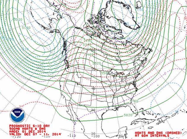
After a numbing November for the northern tier of the USA it looks like
the weather pendulum may swing in the other direction for much of
December, as prevailing steering winds aloft become more westerly with
time - possibly a symptom of a strengthening El Nino signal in the
Pacific. No telling how harsh January will be yet, but December may wind
up milder than November, which is a bit odd.
An Early January Thaw?
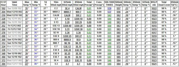
The GFS, along with almost every other model we study, show milder
Pacific air surging across the Plains into the Midwest mid-December,
with a streak of highs in the 30s, maybe a few days in the 40s as we
start to lose snow cover. There's only 2" on the ground right now at MSP
- that may be mostly gone after our second or third day in the 30s.
Temperatures at 850 mb are consistently above zero, suggesting more rain
than snow between December 9 and 17.
Symptoms of El Nino?
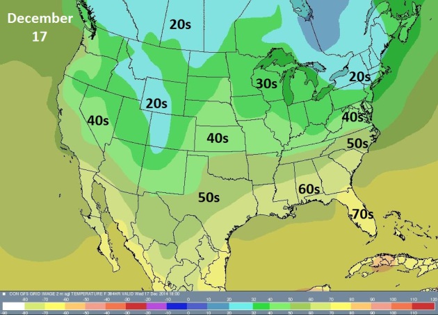
It may be premature making the connection, but it would appear the
pattern is shifting, and the timing coincides with a strengthening El
Nino warm phase in the Pacific, spawning a potential Conga-line of
storms for the west coast. Watch, California will go from epic drought
to epic floods in the coming weeks. The map above shows NOAA's GFS high
temperatures on December 17.
Firehose of Pacific Moisture.
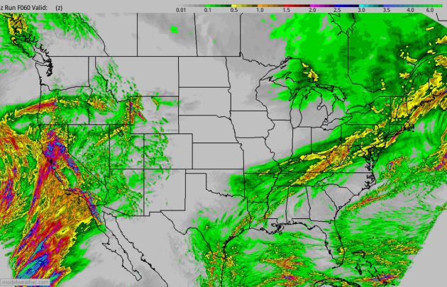
Some of our internal models are printing out 2-4" rains over the next
72 hours from the Bay Area southward to San Diego. Flash flooding and
mudslides appear to be inevitable as the jet stream shifts south,
setting the stage for a warming trend across much of the USA over the
next 1-2 weeks. 60-hour accumulated rainfall courtesy of NOAA and
HAMweather.
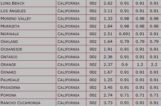
 Flash Flood Potential
.
Our internal models are printing out some 3"+ rainfall amounts from Los
Angeles and Pasadena to Rancho Cucamonga, California in the coming
days. I expect significant flooding and numerous mudslides as excessive
rains fall on land parched by drought and wildfires.
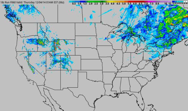
60-Hour Snowfall Potential.
Another 6" of snow may delight skiers out at Jackson Hole; a few inches
from the Poconos to the Catskills. Buffalo should be spared any heavy
snow in the short term as well.
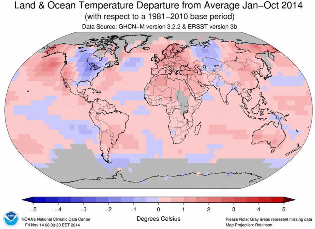
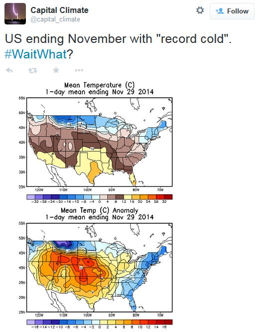
NOAA: 2014 Is Shaping Up As Hottest Year On Record.
CNN has the story; here are a couple of excerpts that caught my eye: "...
The
first ten months of 2014 have been the hottest since record keeping
began more than 130 years ago, according to data from the National
Oceanic and Atmospheric Administration. That may be hard to believe for
people in places like Buffalo, New York, which saw a record early
snowfall this year. But NOAA says,
despite the early bitter cold across parts of the United States in
recent weeks, it's been a hot year so far for the Earth....There was
also one notable cold spot on the map. The average temperature this year
in the midsection of the United States, which saw a severe winter, has
been below the 20th century average..." (Map credit above:
NOAA NCDC).
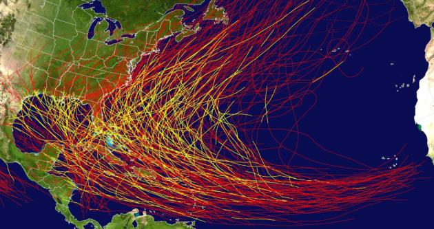
Florida's Hurricane Dry-Spell Lasts.
9 years and counting - how long will The Sunshine State's luck hold
out, and will there be enough money to fix the repairs from the next,
inevitable major hurricane? Here's a snippet of a fascinating story at
The Wall Street Journal: "...
The
fortuitous run of hurricane-free years has allowed the state to keep
insurance costs artificially low for many homeowners and still build up
coffers to pay claims. Yet a devastating storm or series of smaller ones
risk wiping out the cushion built up by Citizens Property Insurance
Corp., the state-owned “insurer of last resort,” and two other
state-controlled entities—putting all insured residents on the hook for
potentially billions and even tens of billions of dollars. “It’s not
strategy—it’s dumb luck,” said Lynne McChristian, a representative of
the Florida office of the Insurance Information Institute, a trade group..." (Major hurricane tracks since 1851: NOAA NHC).
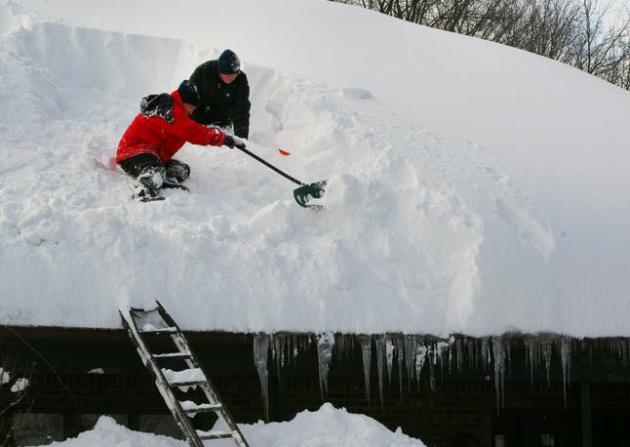
Meteorologists: Cuomo's Weather Claims Are All Wet.
AP's My Way News
highlights a new, pending New York State mesonet. It's great to have
higher resolution (current) data, but would this have made a material
difference forecasting 7 feet of lake effect snow 2-4 days out? Probably
not: "...
Gov. Andrew Cuomo wants New York to create the nation's
best weather monitoring system, one more robust than even the National
Weather Service and more capable of predicting events like the snowstorm
that buried parts of the Buffalo area under 7 feet of snow. But
although Cuomo's $18.7 million initiative will help the state respond to
events like floods or wildfires, it's unlikely to live up his grander
expectations, meteorologists say..." (Photo credit: Mark Mulville, Buffalo News, AP).
*
The New York Times
has their take on Gov. Cuomo's new proposed New York State mesonet;
what it can do, and what it won't be able to do (predict lake effect
days in advance).
How Dogs Understand What We Say. NPR has an interesting story -
here's a link and excerpt: "...
We
know quite a bit about how much dogs get about how we say things,
Andics says, "but we know quite little about how much dogs get about
what we say to them." That's about to change. Psychologists reported
Wednesday in the journal Current Biology that dogs do pay attention to
the meaning of words. And they process that information in a different
part of the brain than where they process emotional cues in speech..."
Night Vision For Your iPhone 6? Because who doesn't need to navigate in the dark every now and then, right?
Gizmag has the review - here's the introduction: "
We're
now well within the midst of a gold rush, when it comes to smartphone
cases that "do things." Recent examples include models that shoot pepper spray, serve as health monitors, and double as game controllers.
The Raspberry Pi-based NVC (Night Vision Camera) case, however, has its
own trick up its sleeve – it lets the iPhone 6 see in the dark..."
TODAY: Mostly cloudy and breezy. Not as cold. Winds: S 10-15. High: 25
TUESDAY NIGHT: Patchy clouds, still chilly. Low: 10
WEDNESDAY: Partly sunny, still colder than average. High: 22
THURSDAY: A little snow or flurry activity. Icy coating? Wake-up: 16. High: 27
FRIDAY: Mix of clouds & sun. Not bad. Wake-up: 15. High: 31
SATURDAY: Sunny, thawing out nicely. Wake-up: 18. High: 34
SUNDAY: Mostly cloudy, OK travel weather. Wake-up: 24. High: 36
MONDAY: Mostly cloudy, colder wind kicks in. Wake-up: 21. High: 26
Climate Stories....
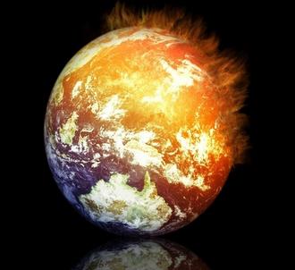
We're Kidding Ourselves on Global 2-Degree Global Warming Limit: Experts.
NBC News has the video and story; here's an excerpt: "...
World
leaders have voluntarily committed to limit warming by the end of the
century to 2 degrees Celsius (3.6 degrees Fahrenheit) above the
pre-industrial level, a threshold beyond which, scientists argue, severe
drought, rising seas and supercharged storms as well as food and water
security become routine challenges. Given the world's historic emissions
combined with a continued reliance on fossil fuels to power humanity
for the foreseeable future, limiting the increase to 2 degrees Celsius
is all but impossible, according to David Victor, a professor of international relations and an expert on climate change policy at the University of California, San Diego..."
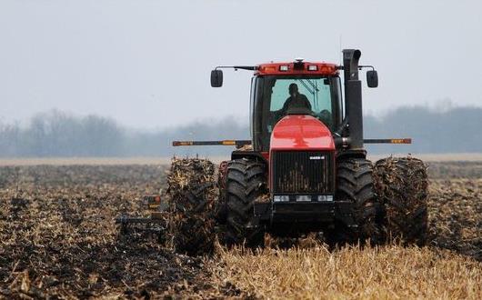
No-Till Farming Might Help Counter Climate Change.
The Argus Leader
has the article, focusing on how the University of Minnesota is working
with farmers on no-till solutions; here's an excerpt: "...
At the
end of each harvest season, farmer Dean Dostal of Hutchinson, Minn.,
carefully tends to his corn and soybean crops, preparing for the next
year’s planting season. It’s a familiar routine for most farmers. But
unlike many, Dostal told The Minnesota Daily, he won’t till to prep his
fields for next season. By not tilling, farmers can increase crop yields
and reduce fossil fuel use while preserving the soil’s essential
nutrients, experts say. Ultimately, that might help slow the effects of
climate change..."
Photo credit above: "
A University of Minnesota study suggests no-till farming cuts down greatly on the release of potent greenhouse gases." (Photo: AP file photo)
Report Examines Climate Change Risks for Human Populations.
Medical News Today has an overview of the Royal Society report; more details below: "...
The
report states that from 1980-2004, the cost of events related to
extreme weather came to a total of $1.4 trillion worldwide, and only a
quarter of this was insured. What is more, people in countries with a
low Human Development Index comprise 11% of those exposed to hazards but
account for 53% of disaster mortality. Regarding risks to people from
floods, droughts and heatwaves, the report notes that people living in
East, West and Central Africa - as well as India and South-East Asia -
are particularly vulnerable as increasing population numbers in these
areas will be exposed to extreme weather events..."
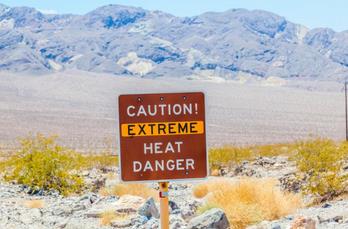
Image credit above: "
The
new report warns that climate change could increase the number of
heatwave exposure events people over 65 experience by three times by the
year 2100, putting them at risk."
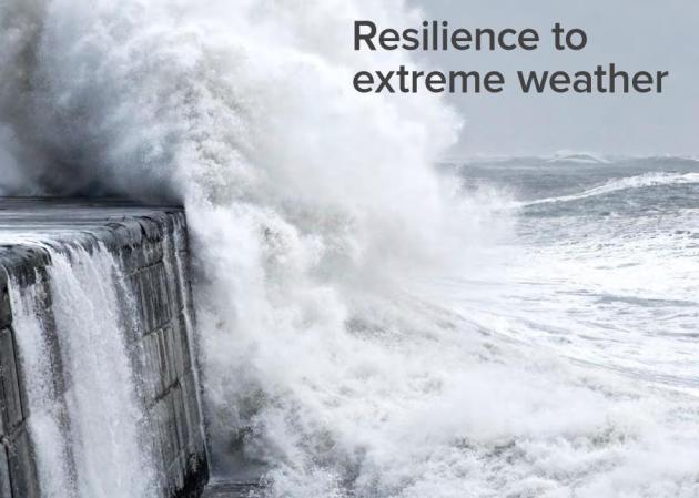
Resilience to Extreme Weather. Here's an excerpt of an overview on the latest document available from the U.K's
Royal Society: "...
‘Resilience
to extreme weather’ investigates these, and other, key questions to
help inform important decisions about adaptation and risk reduction that
are being made at global, national and local levels. We have examined
people's resilience to weather- and climate-related extreme events, in
particular, floods, droughts and heatwaves. We look at how improvements
can be made to protect lives and livelihoods by comparing the options
available and considering the fundamental building blocks for resilience.."
* The full 124 page report (PDF) is
here.
The Language of Climate Change. Is IPCC "alarmist" or being too cautious in the wording of their exhaustively vetted reports? Here's a clip from
Harvard Political Review: "...
On
November 2, the UN’s Intergovernmental Panel on Climate Change (IPCC)
released its most ominous climate report yet, warning of irreversible
climate change effects and the reality of the worsening environmental
situation. Yet to many the report erred on the side of conservatism, and
now that the U.S. midterm elections have ushered many politicians who
oppose the idea of climate change into both the Senate and the House,
the report may have missed the alarmism necessary to enact change for
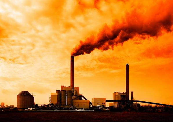
nonbelievers..." (File image: EPA).
Was That Winter Warm? Depends On If You Accept Climate Change.
Keeping a global perspective is hard to do, even for meteorologists who
(usually) fixate on a specific city or state. That's why we have (wait
for it) climate scientists - to provide a worldwide perspective of
temperature trends over time, air, oceans and cryosphere (ice at the
poles). Here's an excerpt from
Ars Technica: "...
When
tackling this topic, it's important to get something out of the way up
front: climate change doesn't dictate whether a single winter will be
warm or cold. It does stack the deck a bit—in the US, record highs are
now far more common than record lows—but it doesn't dictate that every
winter will be warm. There's some evidence that the warming climate is
causing the jet stream to meander more, but that simply leads to more
temperature extremes, as anyone who shivered through last year's US
winter can attest. That said, perceptions of temperature can tell us
things about the psychology that influences how people experience the
world. There's already some evidence that people's ideological
tendencies influence how they perceive temperature; the new study fills
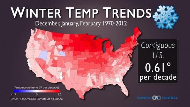
out this picture considerably..." (Observed temperature changes: 1970-2012: Climate Central).
Dismantling Ski Lifts and Moving Villages: Alps Adapt to Climate Change. Here's a clip from an interesting article at
Bangkok Post: "...
A
recent Austrian climate change report found that the country's
temperatures had risen twice as fast as the global average since 1880,
with the number of sunshine hours in the Alps increasing by 20 percent.
While this may please holidaymakers or locals enjoying longer summers,
it is also likely to cause more landslides and forest fires, affecting
the agricultural sector and local economy, the Austrian Assessment
Report found..."
Photo credit: "
Skiiers ride a lift to the slopes the Val Thorens ski resort as the skiing season opens on November 22, 2014, in the French Alps."


No comments:
Post a Comment