24 F. average high on January 26.
18 F. high on January 26, 2014.
1" snow on the ground at MSP International Airport.
January 26, 2006: A record high temperature of 50 degrees is set at the Eau Claire Regional Airport.
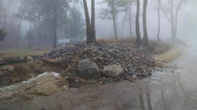
Creeping Shorelines
A baffling, super-sized January Thaw is doing more than frustrating snow lovers. Huge swings in temperature either side of 32F are creating tremor-size cracks in parking lots. The premature freeze-thaw cycle is rearranging shorelines on lakes up north.
A friend, Jim Tucker, lives in Pequot Lakes. He showed me massive berms of sand and rock pushed toward shore. Every new dip below freezing causes expansion of water, sand & mud, creating new lakeshore headaches. One of Jim's photos is above - he hasn't seen anything like this in January before.
The freeze-thaw cycle comes in March, not January, but someone forgot to tell Old Man Winter.
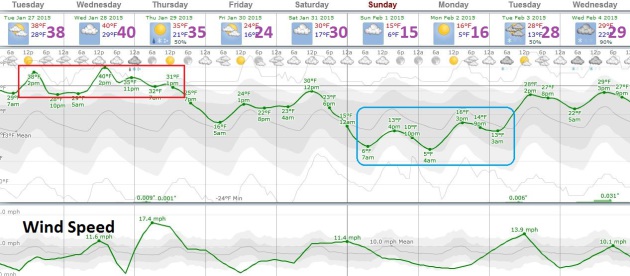
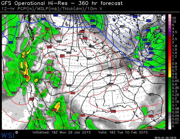
Talk about a disconnect: an historic blizzard has shut down much of the Northeast; it's the rough equivalent of a tropical storm, but with snow and subzero wind chills. While I receive increasingly frantic notes from snow fans. For the record: I haven't given up on snow, but El Nino will continue to divert MOST sloppy storms well south and east of Minnesota. 40s into Wednesday, then a chance of light snow Saturday. We catch a cold early next week (2 days of wind chill) but models show a predominately Pacific flow, with one mild front after another, into much of February.
Feels a little like 2012.

* What may become a Top 10 Snowstorm from New York City to Boston continues to intensify; blizzard conditions likely from this evening into Tuesday, extending into Wednesday morning in the Boston area.
* 1 to 3 foot snowfall amounts still likely from New York City and Long Island to Hartford, Providence, Boston and Portland. By Tuesday night and Wednesday there may be reports of 4-6 foot drifts as virtually all traffic, land and air, grinds to a halt for the better part of 48 hours.
* With winds gusting over 50 mph into Tuesday the risk of power outages will be high. Resources to track power outages, state by state, below.
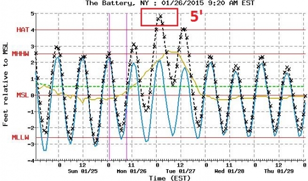
* Significant risk of coastal flooding and beach erosion, especially at high tide over the next 24 hours.
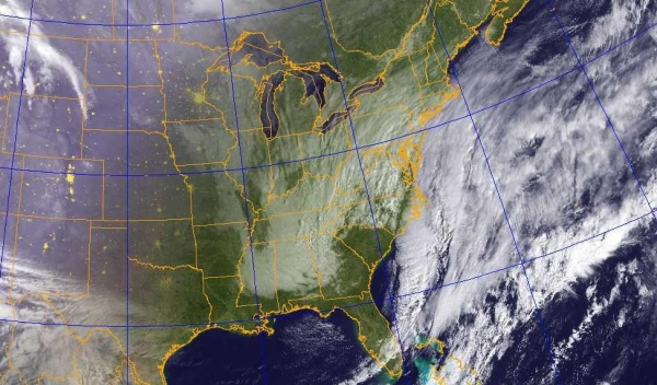
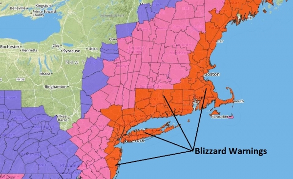
Models are in fairly good agreement:
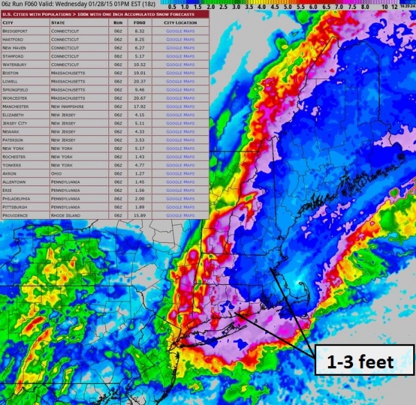
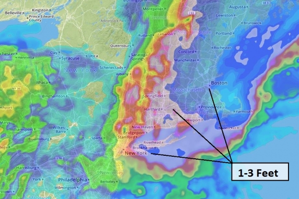
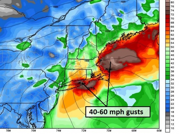
New York ---
- Consolidated Edison Company of New York (Con Edison) - http://apps.coned.com/stormcenter_external/default.html
- PSEG Long Island - https://www.psegliny.com/c.cfm/Outage
- National Grid - https://www1.nationalgridus.com/PowerOutageMap-MA-RES?ng=us
- New York State Electric & Gas (NYSEG) - http://outagemap.nyseg.com/ny/?style=newyork
- Atlantic City Electric - http://www.atlanticcityelectric.com/pages/connectwithus/outages/outagemaps.aspx
- Public Service Electric and Gas Company (PSE&G) - http://outagecenter.pseg.com/external/default.html
- Jersey Central Power and Light Company - http://outages.firstenergycorp.com/nj.html
- Connecticut Light & Power - http://www.cl-p.com/outage/OutageMap.aspx
- United Illuminating - http://bit.ly/1ePFt5J
- Delmarva Power - http://www.delmarva.com/home/emergency/maps/stormcenter/
- Delaware Electric Cooperative - http://www.delaware.coop/my-services/outage-map--
- National Grid - https://www1.nationalgridus.com/PowerOutageMap-RI-RES
- NSTAR - http://outagemap.nstar.com/outage/OutageMap.aspx
- Western Massachusetts Electric - http://www.wmeco.com/outage/outagemap.aspx
- National Grid - https://www1.nationalgridus.com/PowerOutageMap-MA-RES?ng=us
- Public Service of NH - http://www.psnh.com/outage/outagemap.aspx
- National Grid (including Granite State Electric) - https://www1.nationalgridus.com/PowerOutageMap-MA-RES?ng=us
- Central Maine Power - http://www.cmpco.com/outages/outageinformation.html
- Emera Maine - http://apps.emeramaine.com/about/outages/Outage_Map.cfm
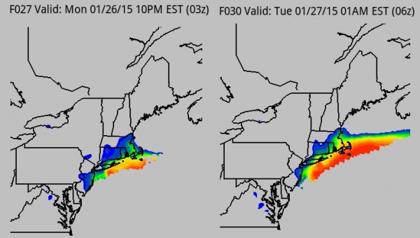
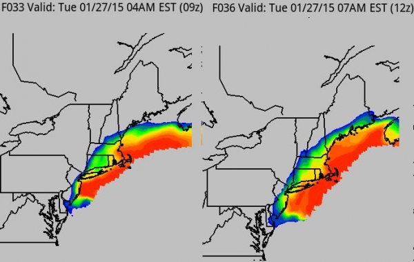
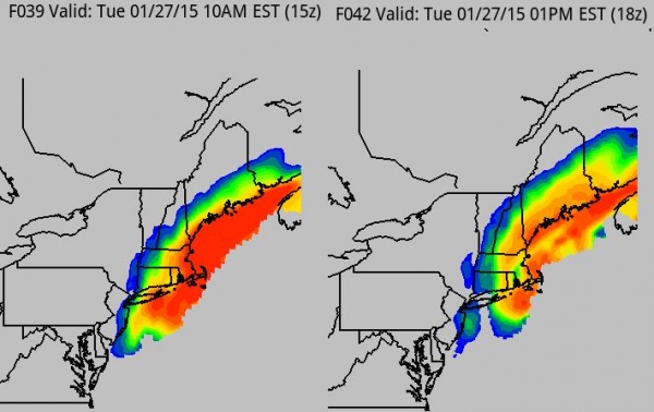
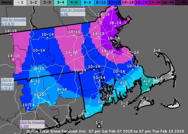
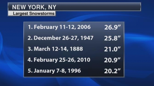
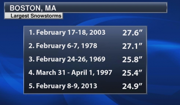
Summary: The media coverage is probably warranted this time around. The most significant blizzard to strike New York City and Boston in at least a decade is winding up. What makes this storm especially dangerous and impactful is a combination of factors:
* 1-3 feet of snow NYC to BOS, but cold surface temperatures will mean a dry, powdery snow, prone to blowing and drifting. Some spots will wind up with 4-6 foot drifts, meaning impacts much of this week. Things may not get back to normal (whatever that is) by the end of the week.
* High winds, gusting over 50 mph tonight into Tuesday, increasing the risk of power outages. I could see emergency warming centeres, even some evacuations of people from their homes, late tonight into early Wednesday.
* Coastal flooding. High tide will bring lowland and coastal flooding from midnight tonight into the afternoon hours tomorrow.
* Bitter temperatures. Readings falling into the teens tomorrow with a subzero windchill will increase the risk of frostbite and hypothermia, for people caught outdoors, and people indoors lacking electricity.
We'll have another update Tuesday morning. Good luck, hunker down, and don't push the weather!
Paul Douglas - Senior Meteorologist - Alerts Broadcaster


Millions of GMO Insects Could Be Released in Florida Keys. The Associated Press has the story - here's the introduction: "Millions
of genetically modified mosquitoes could be released in the Florida
Keys if British researchers win approval to use the bugs against two
extremely painful viral diseases. Never before have insects with
modified DNA come so close to being set loose in a residential U.S.
neighborhood..."


TODAY: Peeks of mild sun. Too easy. Winds: South 5. High: near 40
TUESDAY NIGHT: Partly cloudy, relatively mild. Low: 28
WEDNESDAY: What January? Thaw lingers with some sun. High: 42
THURSDAY: Flurries, cooler breeze late. Wake-up: 30. High: 35
FRIDAY: Cool sunshine, closer to average for late January. Wake-up: 20. High: 27
SATURDAY: Slight chance of light snow. Wake-up: 21. High: near 30
SUNDAY: Sunny intervals, turning colder. Wake-up: 8. High: 15
MONDAY: Sunny, cold Groundhog Day. Wake-up: 6. High: 16
Climate Stories...
.jpg)
Climate Change Expected To Bring More Extreme La Ninas. Here's an excerpt from a story at CBS News: "...A new study concludes that extreme La Nina events like this will become twice as likely in the future due to climate change. The study in Nature Climate Change found that the La Nina extreme weather -- which happens about once every 23 years -- will occur every 13 years by the end of this century, based on an analysis of 21 climate models. Three-quarters of those increased La Nina events would follow extreme El Nino events "thus projecting more frequent swings between opposite extremes from year to the next..."
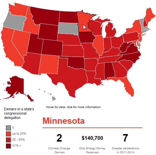


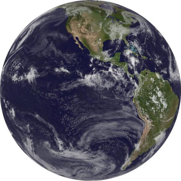
How Much Is Climate Change Going To Cost Us? Those with the least will be first to feel the impacts of climate volatility, in fact it's already happening. Here's a snippet of a long but excellent article looking at various scenarios from David Roberts at Grist: "...In a sense, this restates what we already know: Rich countries could do all right with slow mitigation because they are relatively robust in the face of climate impacts, but it would be devastating to poor countries. Aggressive mitigation is justified because of the threat to poor countries. (This tells you a lot about the politics of the issue.) OK, that’s what you need to know: that there is good reason, outside contested questions of “raw moralism,” to think that the models we use to assess the social cost of carbon are considerably understating it..."
No comments:
Post a Comment