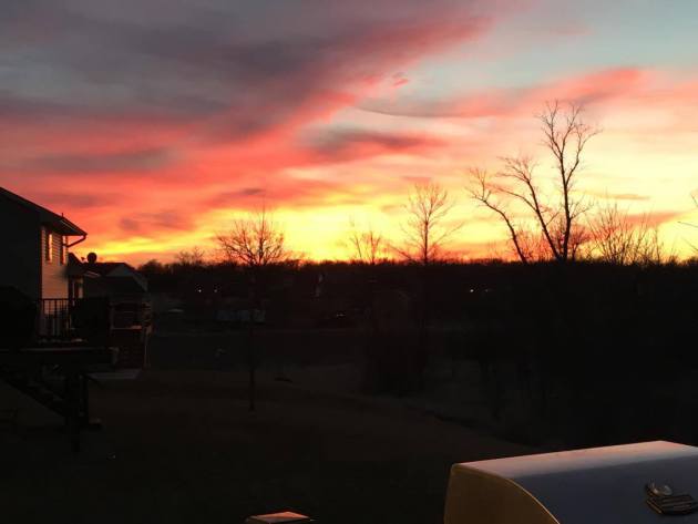
Thanks to my good friend Wanda Brandt from Duluth, MN for this picture below, who woke up on Wednesday to a fresh coating of snow. Heavy snow continued throughout much of the morning with snowfall rates that exceeded 1" per hour in some cases.

Snowfall Tallies
Here were some of the snowfall reports through Wednesday evening. Note that a few locations were reporting nearly 6" of snow or more!

Radar Wednesday Morning
Here's the radar from early Wednesday, which showed heavy snow falling over the western portions of Lake Superior. During this time, snowfall rates exceeded 1" per hour.
.gif)
Minor Relapse - Cosmetic Coating of Flurries?
By Paul Douglas
March is a troubled month; just about the only time blizzards, floods & tornadoes can show up in the same forecast for the same zip code.
The sun is as high in the sky as it was in late September, but snow is on the ground across Canada, whipping up huge north-south temperature contrasts, capable of whipping up wicked storms.
On this date in 1965 a whopping 2 feet of snow crippled northern Minnesota. But on March 17, 2012 the Twin Cities saw 80F; the warmest day of the warmest March in the historical record.
Bottom line: I'm not freaking out about flurries and a few slushy lawns. Our temperatures run a few degrees below average into Monday before readings mellow a bit next week. A few icy spots are possible first thing Friday morning with temperatures just below 32, but MSP avoids the plowable snowfall that has transformed northern Minnesota into a winter wonderland. Imagine that. Snow in March!
No more 50s or 60s the next couple of weeks; the pattern looks cool & quiet into early April.
No epic floods, beach ball-size hail, locust, plagues or pestilence in sight.
____________________________
WEDNESDAY NIGHT: Breezy. Mostly cloudy with lshowers mixed with a little snow late. Winds: WNW 15-30. Low: 34
THURSDAY: Light rain/snow mix. Winds: NW 10-20. High: 39
THURSDAY NIGHT: A little slushy coating overnight? Winds: NNE 5-10. Low: 29
FRIDAY: Slick spots early? Chilly, few leftover flurries. Winds: NNE 5-10. High: 38
SATURDAY: Nagging clouds and flurries. Winds: N 5-10. Wake-up: 27. High: 41
SUNDAY: Intervals of sun, a little nicer. Winds: NW 7-12. Wake-up: 29. High: 44
MONDAY: Partly sunny, seasonably cool. Winds: E 10-15. Wake-up: 30. High: 43
TUESDAY: Patchy clouds, a bit milder. Winds: SE 8-13. Wake-up: 32. High: 48
WEDNESDAY: Unsettled, passing shower possible. Winds: N 10-15. Wake-up: 37. High: 42.
_____________________________
This Day in Weather History
March 17th
2012: The Twin Cities hits 80 degrees, a new record for St. Patrick's Day and the warmest temperature during the warmest March on record. Amazingly, the high also reached 79 on March 16, 18, and 19 this year.
1965: The Great St. Patrick's Day Blizzard hits northern Minnesota. Two feet of snow dumped at Duluth. 19 inches at Mora.
______________________________
Average High/Low for Minneapolis
March 17th
Average High: 42F (Record: 80F set in 2012)
Average Low: 25F (Record: -8F set in 1941)
______________________________
Sunrise/Sunset Times for Minneapolis
March 17th
Sunrise: 7:21am
Sunset: 7:22pm
*Daylight Gained Since Yesterday: ~3mins & 9secs
*Daylight Gained Since Winter Solstice (Dec. 20th): ~3hours & 15mins
_____________________________
Moon Phase for March 17th at Midnight
2.6 Days Since First Quarter

__________________________________
Tuesday Sunset

Minneapolis Temperature Trend
While temperatures have cooled considerably since the 60s and 70s that we had last week, reading will actually be closer to average for mid-March over the next several days. The extended forecast doesn't suggest any substantial warming or cooling taking place over an extended period through the end of the month.
__________________________________
6 to 10 Day Temperature Outlook
According to NOAA's CPC, the 6 to 10 day temperature outlook suggests an above normal chance of warmer than average temperatures returning to the Central U.S. next week.
_______________________________
Weather Outlook Thursday
Temperatures on Thursday will be more representative of mid-March with highs in the 30s and lower 40s. However, breezy winds will still make it feel cooler with readings in the 20s and 30s by midday.

Weather Outlook Thursday
Winds won't be quite as strong on Thursday as they were on Wednesday, but winds still may gust up close to 30mph from the Dakotas and far southwestern Minnesota to near the Windy City of Chicago.

Simulated Radar
Here's the simulated radar from Wednesday to PM Friday. Note that the heaviest steadiest rain/snow on Wednesday across northern MN and WI becomes a little more spread out and less intense through the end of the week. Rain/snow chances will possible, but any additional precipitation amounts across central and southern Minnesota look fairly light.

Precipitation Outlook
Heavy precipitation from earlier this week will continue to fade over the Upper Mississippi Valley/Western Great Lakes Region. Here's the additional precipitation potential from midday Wednesday to 7pm Friday.

Snowfall Outlook
Snowfall amounts will continue to taper through the end of the week, with the heaviest falling through AM Thursday. Note that snowfall accumulations along and south of the I-94 corridor look to be pretty non existent. Again the heaviest snow will fall through PM Wednesday/AM Thursday.

______________________________________
"Minnesota's winter low temps continue rising"
Here's an interesting article from Mary Jo Webster at StarTribune.com regarding rising low temperatures in Minnesota...
"If Minnesota winters seem warmer than when you were a kid, you're not imagining it."
"The statewide average low temperature for December-February this year came in at 11.8 degrees, a marked difference from years past. This continues a decades-long upward climb in winter low temperatures that scientists attribute to climate change. Sure, there are winters (like 2013-14) that have been phenomonally cold, and certainly this year's spike could prove to be an anamoly. But even without those outliers, there has been a clear upward trend in the average low temperatures that has been most prominent in the past 35 years. Average March Temperature"
See the full story from StartTribune.com HERE:
_______________________________
March Temperatures So Far...
No question, temperatures so far this March are running well above average in Minneapolis. In fact, through the first 15 days, we were running 13F above average and would've been the 5th warmest March on record if the month would've ended on Tuesday.
Earliest Ice Out Dates
Due to a lack of snow and very warm temperatures end the of meteorological winter/beginning of meteorological spring, ice on Minnesota lakes has been looking pretty pitiful. Here's a look at the earliest ice out dates on record across the state.
See more from MN DNR HERE:

Average Ice Out Dates
The MN DNR also has average ice out dates for lakes across the state, which show that most lakes in central and southern Minnesota don't start seeing ice outs until late March and or early/mid April.

___________________________________
National Weather Outlook
The strong low pressure system over the Great Lakes will begin to deteriorate through the end of the week. Heavy snow will fade to a lighter rain/snow mix and strong winds will begin to subside as the storm drifts east by Friday. However, a stalled front across the Gulf Coast States will continue to kick out heavier pockets of rain and a few inches of snow will drift through the Rockies/Central Plains through the end of the week.

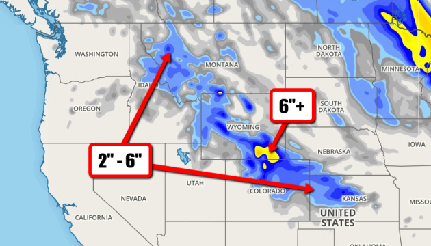
Snow in the Rockies
Another area that will see snow potential will be the Rockies and parts of the Central Plains. The forecast calls for light accumulations with some near 6"+ amounts in SE Wyoming and N Colorado.

5 Day Precipitation Outlook
According to NOAA's WPC, the 5 day precipitation forecast suggests some 1" to 2"+ rainfall tallies across the southern Gulf Coast States, which may lead to additional flood concerns there. Also note the heavier moisture just east of the Northeast Coast... this may be a developing storm worth watching.

___________________________________
A Late Weekend Storm in the Northeast?
Latest model runs continue to show a system developing late weekend near the Northeast. This could bring snow to the Northeast, but it also could completely miss... Keep any eye on forecasts as we head into the weekend as winter weather could impact travel into the weekend/early next week.

______________________________________
Eastern Pacific Water Loop
After several waves of heavy moisture in the Western U.S., weather conditions have calmed down a little. However, it appears that more waves of energy are brewing in the Eastern Pacific that could bring more heavy moisture to the West Coast late weekend/early next week!

____________________________________________
Precipitation Month to Date
Here's the NWS precipitation analysis since March 1st, note that some locations across parts of California and the Pacific Northwest have seen nearly 12"+ of rain!

California Reservoirs
Here's a little bright spot in the drought conditions... recent moisture over the past several weeks has helped to fill up some reservoirs in the northern part of the state to at or slightly above the historical average! However, note that most of the reservoirs in the state are still running well below average.

_________________________________________
PRELIMINARY 2016 Tornado Count
Weather conditions were a little unsettled earlier this week with tornadoes being reported Monday, Tuesday & Wednesday. According to NOAA's SPC, the PRELIMINARY 2016 tornado count through March 15th suggests that there have been nearly 200 tornado reports so far this year. Interestingly, this is the most active start to a season since 2012!

_____________________________________
8 to 14 Day Temperature Outlook
According to NOAA's CPC, the 8 to 14 day temperature outlook suggests a good chance of warmer than average temperatures across much of the southern U.S. through the end of the month.

_____________________________________
"Heat Waves, Droughts and Heavy Rain Have Clear Links to Climate Change, Says National Academies"
Scientists can now say with confidence whether heat waves, such as the one that struck Russia in 2010 and caused 55,000 deaths, are linked to climate change. But when it comes to storms like Typhoon Haiyan, which battered the Philippines last year, their methods hit a brick wall of uncertainty.
The findings are included in a sweeping report the National Academies of Sciences, Engineering and Medicine released last week that tries to answer the question often posed after a nasty spell of weather.
Was it triggered by humanity’s carbon emissions?
See the full story from ScientificAmerican.com HERE:
 ______________________________________
Thanks for checking in and have a great rest of your week/weekend ahead! Don't forget to follow me on Twitter @TNelsonWX

No comments:
Post a Comment