38 F. average high on March 9.
57 F. high on March 9, 2015.
Trace of rain fell yesterday (drizzle).
March 10, 2012: The record high of 66 degrees at the Twin Cities is the first of 8 record highs in a 10-day span.
March 10, 1948: Bitterly cold conditions, especially for March, occur in Minnesota. A low of -44 is reported at Itasca.
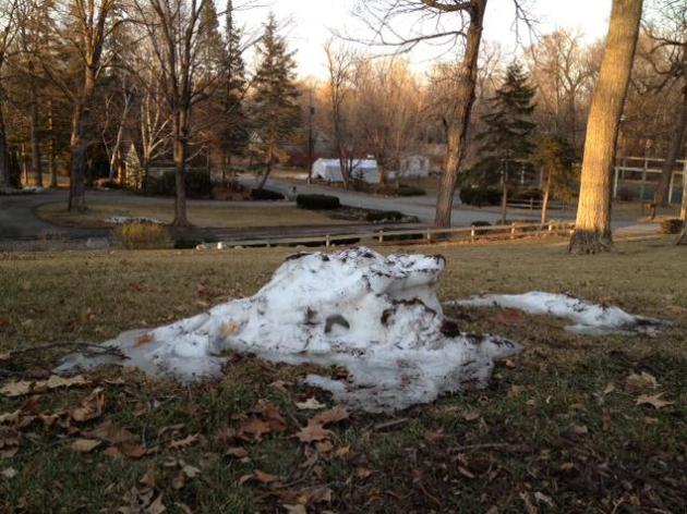
Springy Next 7 Days - One More Slushy Smack?
I apologize. I may have inadvertently angered the weather gods with my "winter is over" comment the other day. It's the kind of black and white statement that invites atmospheric retribution.
We just enjoyed/endured the 8th warmest meteorological winter on record in the Twin Cities. Open water in December. 10 subzero nights (typical for Kansas City). One real "storm" on Groundhog Day. 70F on Tuesday was the 3rd earliest on record at MSP.
The same El Nino signal pounding California and flooding some parishes in Louisiana with a tropical storm's worth of rain keeps us mild the next 7 days. 60F is possible Friday and Saturday before light showers arrive on Sunday. Models spin up a more impressive storm next Wednesday; probably warm enough aloft for heavy rain (and strong winds) but I can't rule out a little slush or a light mix late next week as temperatures cool off.
NOAA's GFS model hints at a few stronger/colder slaps of Canadian air within 1-2 weeks but the ECMWF model keeps the coldest air to our north.
Spring break is coming early this year - but hold off on gardening a little while longer.
3 PM Friday. Here is why I'm concerned, widespread 60s, even a chance of 70F over western and southwestern Minnesota Friday afternoon. NAM guidance hints at 63 F in the metro - just mild enough to break out into a spring-fever-sweat. Source: AerisWeather.
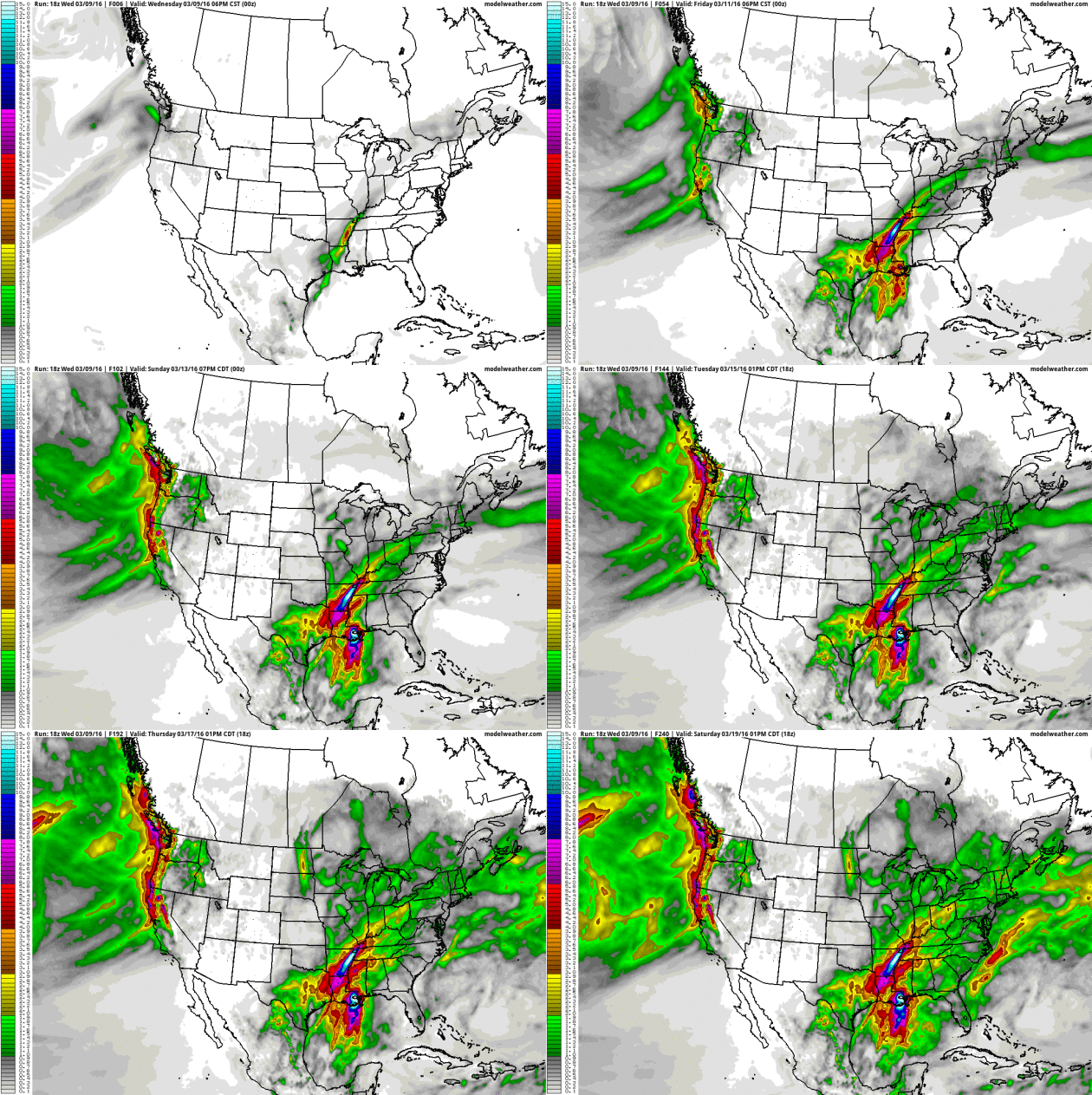
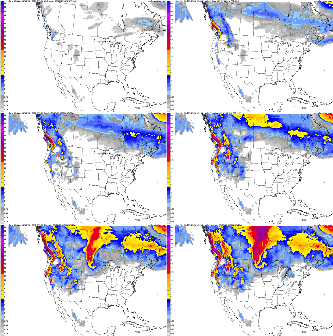
* More details on Louisiana's Flood Emergencies (one step up from a Flood Warning - meaning imminent threat to life and property) from CNN.
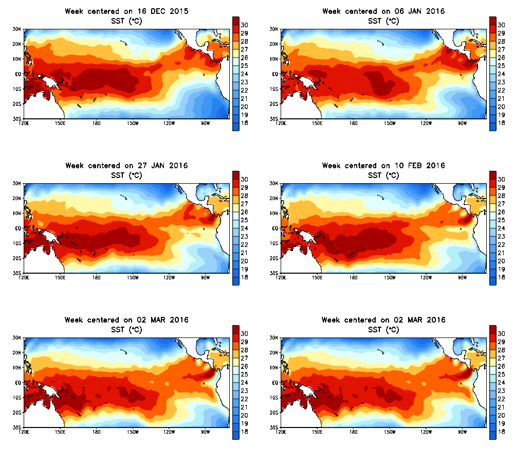
Animation credit: NOAA CPC.
Map credit: "Winter severity classification, March 7, 2016." (Midwestern Regional Climate Center)
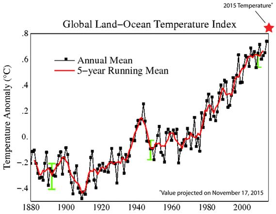
Warmest Winter on Record for the USA. Following the warmest year on record (2015), which broke the previous record for warmth (2014), when there was no El Nino to blame - or thank. It must be another coincidence. Here's an excerpt from NOAA NCDC: "The strong El Niño that was present in the Equatorial Pacific interacted with other climate patterns to influence U.S. weather conditions during winter and February. The December-February average temperature for the contiguous U.S. was 36.8°F, 4.6°F above the 20th century average, surpassing the previous record of 36.5°F set in 1999/2000. The exceptionally warm December boosted the contiguous U.S. winter temperature. The February temperature for the contiguous U.S. was 39.5°F, 5.7°F above the 20th century average, ranking as the seventh warmest on record and warmest since 2000..."
It's Official: This Was America's Warmest Winter on Record. More perspective from Eric Holthaus at Slate; here's a clip: "...NOAA blames the recent warm weather on a record-strength El Niño “and other climate patterns,” most notably, global warming. As a whole, this winter in the lower 48 was about 4.6 degrees Fahrenheit warmer than the 20th century average: a sharp contrast to the previous back-to-back frigid polar vortex winters, especially in the Northeast. But that doesn’t mean there was a lack of wintry weather: New York City, for example, had one of its warmest and snowiest winters on record, an odd combination to say the least..."
Graphic credit above: "Winters are warming, and this was the warmest one yet." NOAA.
Extreme Weather Disasters Since 2010. A short window of data, but an interesting overview of state and national trends in recent years, courtesy of Environment America: "Every year, weather-related disasters injure or kill hundreds of Americans and cause billions of dollars in damage. Many of the risks posed by extreme weather will likely increase in a warming world. Scientists have already noted increases in extreme precipitation and heat waves as global warming raises temperatures and exacerbates weather extremes. The stories shared on the map show how global warming is affecting our lives as individuals. The negative impacts of global warming are felt differently by different people, depending their age, health and circumstances. For some, record heat can be life-threatening, while large snow storms can leave others trapped inside..."
Houston's Perfect Storm.
How much risk are you willing to live with? At some point the law of
averages catches up with you, whether you live in Houston, New Orleans,
Miami or New York City. Here's the intro to a story at The Atlantic: "It
is not if, but when Houston’s perfect storm will hit. They called Ike
“the monster hurricane.” Hundreds of miles wide. Winds at more than 100
miles per hour. And—deadliest of all—the power to push a massive wall of
water into the upper Texas coast, killing thousands and shutting down a
major international port and industrial hub..."
Photo credit above: "A resident removes a sign from the coast as Hurricane Ike approaches in Galveston, Texas in September 2008." Carlos Barria / Reuters.
When It Rains, It Increasingly Pours, Scientists Say.
Real-world observations are falling in line with model projections: wet
areas are (as a rule) getting wetter, dry areas trending drier over
time. Here's an excerpt fromm Bloomberg Business: "...The
overall rain and snowfall average is increasing only moderately. But
observations since 1951 show that the wettest days every year have
increased their intensity by 1 percent to 2 percent per decade,
according to a study published
this week in the journal Nature Climate Change. The heavy precipitation
is increasing over both wet and dry land areas, a surprising conclusion
drawn from the research. A mantra among climate scientists for years
has held that, as humanity continues to pump out carbon pollution,
regions with lots of rainfall will receive more, and relatively arid
places will get even less. That’s a global projection, however, and most
of the globe's surface consists of ocean. More recently, scientists
have wondered if that will hold true over land as well..."
Hotter Planet Spells Harder Rains to Come. More perspective on the study highlighted above; here's a link to new research and a story excerpt at Climate Home: "Severe
rainfall has increased throughout the world’s wettest and driest
regions and is set to intensify this century, new research suggests.
Since 1950, daily extremes have risen 1-2% a decade, a study published
in journal Nature said on Monday. That trend is expected to last until
at least 2100, prompting emergency planners to take precautions against
flash flooding. Dry regions such as Saharan Africa, the Arabian
Peninsula or Australia, whose parched soil poorly absorbs excess water,
would be most vulnerable..." (Image credit: Pixabay).
For Weather Forecasting, Precise Observations Matter More Than Butterflies. Here's a clip from an interesting read at EurekaAlert: "...It's
not necessary to create a dense network of observing stations to
measure the atmosphere at finer and finer scales, Durran said. Instead
of sweating the small stuff, he says, scientists need to improve the way
they assimilate, or input, existing observations of the atmosphere on
horizontal scales between 100 and 300 miles (160 to 480 km) in order to
start local-area forecasts with the best possible description of the air
circulating..."
Photo credit above: "Photo
of a thunderstorm in Owens Valley, California. The butterflies
superimposed on this photo would not matter for the forecast." Credit: Dale Durran/University of Washington.
Bad News: Low-Carbon Air Travel Isn't Very Likely. Is there a technological magic bullet? Here's an excerpt from Grist: "...Fortunately, there’s
a groundbreaking techno-fix just around the corner, waiting to usher in
the clean airplane of the future, right? Wrong. According to these
researchers, that airplane is a false hope that we’ve been clinging
to for more than 20 years, and here’s how they found out: First, the
team compiled a list of 20 efficiency-boosting technologies hyped by the
aviation industry between 1994 and 2013. These potential
game-changers broke down into three broad categories: alternative fuels
like hydrogen, algae, and this stuff that
you’ve probably never heard of; new engines that could, for example,
run on sunlight or electricity; and “airframe” improvements that would
make planes lighter and more aerodynamic..." (Photo: Shutterstock).
The "Sistine Chapel" of Skateboarding? Why not. Here's an excerpt of a wild photo-essay at Slate: "...Spanish artist Okuda San Miguel transformed the former Santa Barbara Church in Llanera, Spain, into La Iglesia Skate,
with contemporary geometric graphics and painted figures in a
psychedelic palette that are in stark contrast with the church’s
ecclesiastical bones. The artist painted the church, originally built in
1912 before it fell out of use at the end of the Spanish Civil War,
during a week in late November, and it opened to the public in December..."
Photo credit above: "Spanish
artist Okuda San Miguel transformed the disused church of Santa Barbara
in Llanera, Asturias, into La Iglesia Skate, a temple of skateboarding." Elchino Pomares.
Don't Mess With Ostriches.
Some things you just have to see to believe. Who knew ostriches could
run this fast? Remember that the next time you pass one on a bike.
Here's an amazing video clip from The Telegraph: "Headcam footage shows an ostrich running at a terrifying 50km/h after a group of cyclists in South Africa."
TODAY: Partly sunny, pleasant. Winds: NW 5-10. High: 52
THURSDAY NIGHT: Clear to partly cloudy. Low: 35
FRIDAY: Sunny, breezy and mild. Winds: S 10-20. High: 63
SATURDAY: Fading sun, late-day showers possible. Winds: S 8-13. Wake-up: 46. High: 63
FRIDAY: Sunny, breezy and mild. Winds: S 10-20. High: 63
SATURDAY: Fading sun, late-day showers possible. Winds: S 8-13. Wake-up: 46. High: 63
SATURDAY NIGHT: A few showers likely. Low: 48
SUNDAY: Unsettled, a few rain showers linger. Winds: SE 10-15. High: 59
MONDAY: Mostly cloudy, stray shower possible. Wake-up: 46. High: 56
TUESDAY: Peeks of sun, still mild. Wake-up: 47. High: near 60
WEDNESDAY: Windy, heavier rain possible. Winds: E 15-25. Wake-up: 48. High: 55
SUNDAY: Unsettled, a few rain showers linger. Winds: SE 10-15. High: 59
MONDAY: Mostly cloudy, stray shower possible. Wake-up: 46. High: 56
TUESDAY: Peeks of sun, still mild. Wake-up: 47. High: near 60
WEDNESDAY: Windy, heavier rain possible. Winds: E 15-25. Wake-up: 48. High: 55
Climate Stories....
Highest Ever Annual Rise in Carbon Dioxide Levels Reached. New Scientist has an update; here's the intro: "It is not just temperature records that are falling. The average carbon dioxide level recorded at Mauna Loa, Hawaii, during February 2016 was 404.02 parts per million – 3.76 ppm higher than the average for February 2015, according to preliminary figures. That is the biggest ever increase over a 12-month period. The previous 12-month record at Mauna Loa was 3.70 ppm, from September 1997 to September 1998..."
Photo credit above: "Mauna Loa Observatory in Hawaii." NOAA.
Darkening Greenland Ice Sheet Melts Faster. Here's an excerpt from Climate Home: "Greenland is getting darker. Climatology’s great white hope, the biggest block of ice in the northern hemisphere, is losing its reflectivity. According to new research, the island’s dusty snows are absorbing ever more solar radiation, which is likely to accelerate the rate at which the icecap melts. The Greenland icecap covers 1.7 million square kilometres and contains enough ice to raise sea levels by seven metres. Right now, the rate of melting is on the increase, and meltwater flowing off the icecap could be raising sea levels by 0.6mm a year..."
Photo credit above: "Greenland’s white ice sheet is not as pristine as it looks." (Pic: NASA/Flickr).
Climate Scientists Step Up Search for "Holy Grail" of Million-Year-Old Ice. The Guardian has a story focused on getting an even longer ice core record; here's a clip: "Somewhere deep below the ice in Antarctica lies a time capsule. It’s the holy grail of climate science and promises to reveal the past and future of Earth’s atmosphere. And right now, scientists are meeting in Hobart to work out a plan to dig it up. The time capsule is ice that froze 1.5m years ago, capturing tiny bubbles of air, bringing a sample of the ancient atmosphere through time to the present day. There are already dozens of ice cores from Antarctica and Greenland. They are tubes of ice, sometimes several kilometres long, drilled from the ice sheet, which reveal a timeline of what the atmosphere was like over hundreds of millennia..."
Photo credit above: "Scientists are meeting in Hobart to work out a plan to find million-year-old ice in Antarctica." Photograph: Sam Crimmin.
Image credit: "Rice cultivation is one of the ways food production pumps methane into the atmosphere." sandeepachetan.com travel photography/Flickr, CC BY-NC-ND
Jay Faison Seeks Partisan Path to Republican Support for Clean Energy. Here's the intro to a story at Charlotte Business Journal: "Charlotte entrepreneur Jay Faison
says he has raised $2 million for what he intends to make a $5 million
SuperPAC to push Republicans to support clean energy issues in
Congressional campaigns across the country. Faison says the political
action committee, ClearPath Action, has made no contributions to any
campaigns as yet. But he expects to announce contributions soon..."
Photo credit above: "Charlotte
entrepreneur Jay Faison and his ClearPath Foundation plan a series of
online ads to draw a sharp partisan line on conservative clean energy
solutions for Republicans." John Downey.
Mogul Opens Wallet to Lure Republicans to Embrace Clean Energy. More perspective on Jay Faison's ClearPath Foundation initiative at Bloomberg Politics: "Entrepreneur-turned-activist
Jay Faison says Republicans’ political survival depends on embracing
clean energy -- whether a candidate believes in climate change or not --
and he’s backing that up with tens of millions of dollars. "Our mission
is to make conservative clean energy a priority for the GOP," Faison
told reporters Tuesday in Washington, where he is opening a new office
for his environmental foundation ClearPath. "It may take some time, but
absolutely, we can do it. It’s critical for the longevity of the
Republican party..."
Photo credit: Carlos Osorio/Associated Press. "Which one would do more to fight climate change?"
Infrastructure
is, by design, largely unnoticed until it breaks and service fails.
It's the water supply, the gas lines, bridges and dams, phone lines and
cell towers, roads and culverts, train lines and railways, and the
electric grid; all of the complex systems that keep our society and
economy running.
Engineers typically design systems to withstand reasonable worst-case conditions based on historical records; for example, an engineer builds a bridge strong enough to withstand floods based on historical rainfall and flooding. But what happens when the worst case is no longer bad enough?
"If we don't adapt the systems, they will break," said Duane Verner, an urban planner who works with Clifford.
Read more at: http://phys.org/news/2016-03-america-cities-drought-climate.html#jCp

Image credit: Momatiuk - Eastcott / Corbis / Zak Bickel / Kara Gordon / The Atlantic.
No comments:
Post a Comment