Radar PM Wednesday/AM Thursday
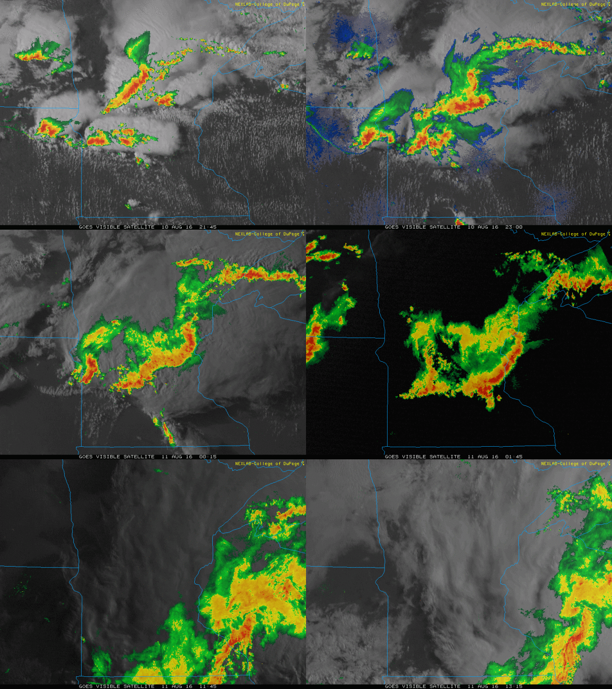
Take a look at the swarms of showers and storms that swamped Minnesota and Wisconsin PM Wednesday/AM Thursday. Thanks to training thunderstorms and abnormally high amounts of moisture in the atmosphere, several locations recorded several inches of rainfall and flooding during this time frame.
Radar Estimated Rainfall
Here's a look at radar estimated rainfall across the Twin Cities CWA from Wednesday to AM Thursday. Note that several locations saw 2" to 4"+ across the region.
Actual Rain Reports
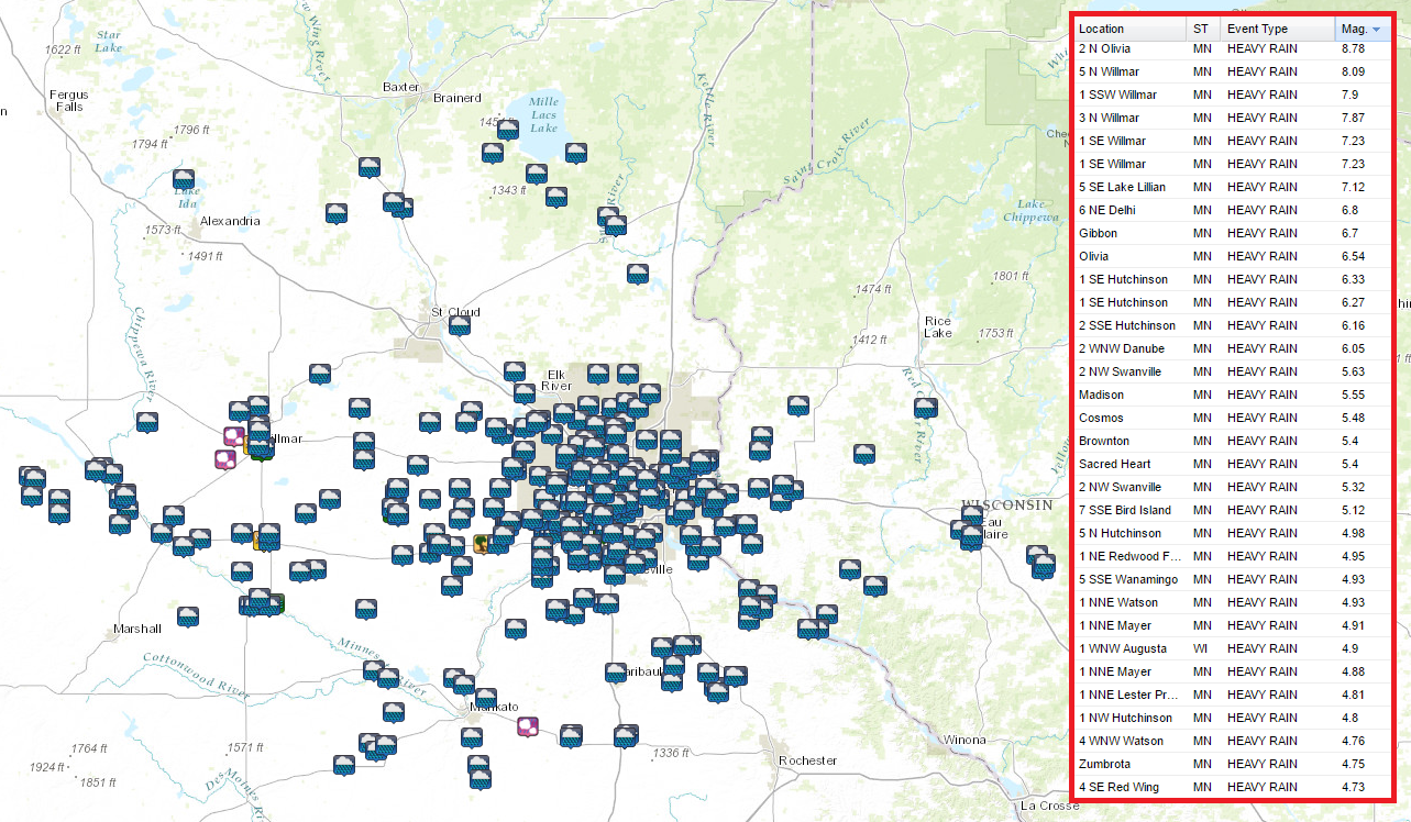
Take a look at all the heavy rainfall reports through AM Thursday. Incredibly, A couple of locations near Olivia and Willmar reported 8" to near 9" of rain!
Worst Nightmare
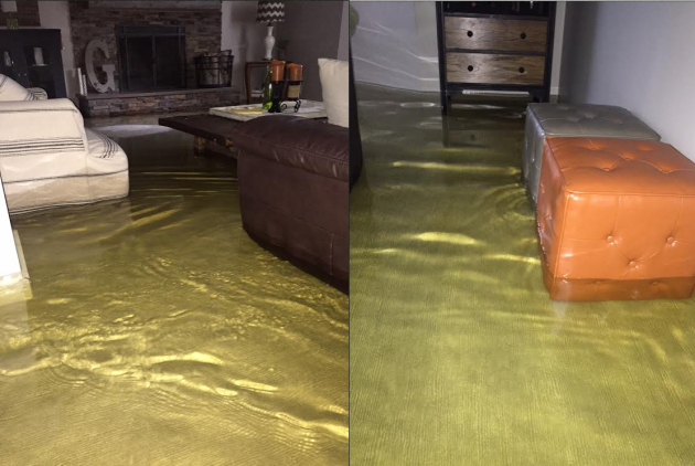
Thanks to Scott from Willmar for the picture out of Willmar... not a scene you want to see when you walk down to the basement. Parts of Minnesota were swamped with heavy rain for an extended amount of time, Willmar ended up with nearly 8"+ of rain PM Wednesday/AM Thursday.
2 Day Rainfall (AM Tuesday - AM Thursday)
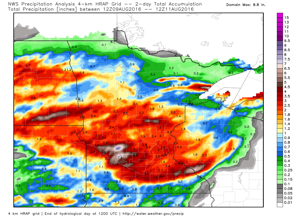
Here's a look at estimated rainfall from AM Tuesday to AM Thursday, which show fairly significant amounts across much of the state. Note the widespread 1" to 2" tallies even in the Twin Cities Metro.
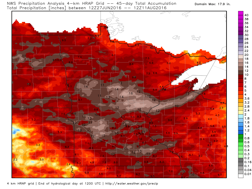
45 Day Rainfall
It has been a VERY wet 45 day stretch across Minnesota and Wisconsin. Note how many double digit values there are across much of central Minnesota. We've had several round of extremely heavy rainfall during the month of July and already during the first 11 days of August.
______________________________
Rains Are Falling Harder - A Break This Weekend
One consequence of the ongoing warming trend: it's raining harder during the summer months. People's eyes glaze over when they hear this. I can almost hear them thinking "So what?"
But there are consequences: more moisture in the air, higher dew points and heat indices, more thousand-year rain events, wet basements with greater regularity, more expensive insurance policies, and farmers having a tough time keeping nutrients, herbicides and pesticides on their fields, and not washing off into the nearest creek.
The stagnant frontal zone that squeezed out 1-2 month's worth of rain for many communities is finally pushing east. Surface winds blow from the northwest today as dew points drop off to more tolerable levels. The sun should be out much of the weekend; PM instability showers may sprout over the Minnesota Arrowhead, but otherwise we dry out nicely.
No more 90s in sight looking out 2 weeks - Canadian cool fronts push into Minnesota with greater regularity. The atmosphere is shifting gears now, trying to help us get into a back-to-school mindset. Ugh. It's still too early.
______________________________
______________________________
Extended Forecast
THURSDAY NIGHT: Chance of storms overnight. Low: 68. Wind: WSW 5mph.
FRIDAY: Spotty thunder possible early, otherwise partly sunny and drier. Winds: NW 8-13. High: 83
FRIDAY NIGHT: Mostly clear and quiet. Low: 64. Winds: NW 5mph.
SATURDAY: Plenty of sun, comfortable again. Winds: NW 8-13. High: 82
SUNDAY: Sunshine lingers, few complaints. Winds: NE 3-8. Wake-up: 65. High: 83
MONDAY: Intervals of sun, isolated T-shower. Winds: S 10-15. Wake-up: 67. High: 86
TUESDAY: Sticky again, more numerous storms. Winds: S 10-15. Wake-up: 69. High: 85
WEDNESDAY: Unsettled. Risk of another t-storm. Winds: SW 5-10. Wake-up: 68. High: 84
THURSDAY: Very muggy, nagging thunderstorm risk. Winds: SW 10-15. Wake-up: 69. High: 85.
________________________________
________________________________
This Day in Weather History
August 12th
August 12th
2000: Record-setting dew points develop in Minnesota. The Twin Cities have a dew point of 76, with a rare dew point of 80 at Faribault.
1821: An eight-day heat wave ends at Ft. Snelling. Temperatures were in the 90's each day.
________________________________
________________________________
Average High/Low for Minneapolis
August 12th
August 12th
Average High: 81F (Record: 94F set in 1965)
Average Low: 63F (Record: 45F set in 1961)
_________________________________
Average Low: 63F (Record: 45F set in 1961)
_________________________________
Sunrise/Sunset Times for Minneapolis
August 12th
August 12th
Sunrise: 6:12am
Sunset: 8:23pm
Sunset: 8:23pm
*Daylight lost since yesterday: ~2mins & 43secs
*Daylight lost since Summer Solstice: ~1hour & 12mins
__________________________________
*Daylight lost since Summer Solstice: ~1hour & 12mins
__________________________________
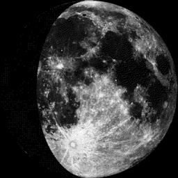
Moon Phase for Friday August 12th at Midnight
2.5 Days Since First Quarter
2.5 Days Since First Quarter
_____________________________________
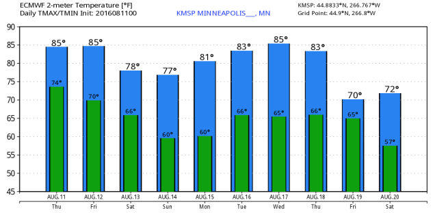
Extended Forecast
Lingering heat and humidity looks to stick around through the end of the week, but it will be much improved this weekend with highs in the 70s to near 80F with lower humidity values. Enjoy another nice weekend ahead before more sticky weather arrives next week.
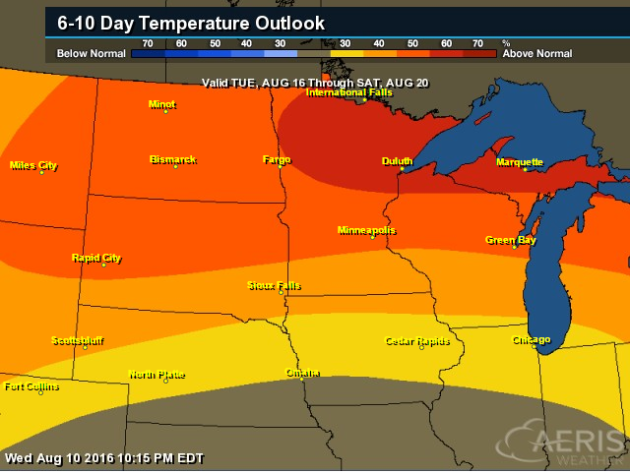
6 to 10 Day Temperature Outlook
According to NOAA's CPC, the 6 to 10 day temperature outlook suggests a fairly decent chance of warmer than average temperatures returning from August 16 - 20. Although average high temperatures have started to retreat from their warmest readings back in mid July, it'll still feel very much like the peak of summer heading into next week with highs in the mid 80s and dewpoints back in the mid 60s.
Friday Weather Outlook
High temperatures on Friday will still be quite mild across the region, but cooler, less humid air will slowly filter into the region late in the day. More comfy air will certainly be noticeable this weekend, but prior to that, highs in the 80s with dewpoints in the 60s will still make it feel a little sticky on Friday.
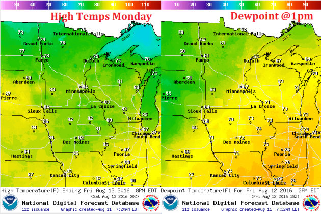
Friday Weather Outlook
Winds will begin to pick up out of the NW on Friday, which will help to slowly push cooler, less humid air into the region. The strongest winds will be found across the Dakotas in into western MN by midday Friday.
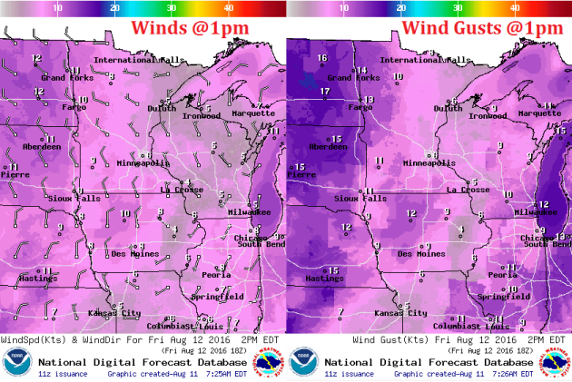
Friday Weather Outlook
Despite a few lingering showers or storms early in the day, we'll undergo a slow clearing trend on Friday with more comfy sun across the western and northwestern part of the state. This clearing trend will continue into the weekend with plentiful sunshine expected both Saturday and Sunday.
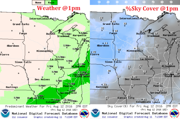
_____________________________________________
Simulated Radar
Here's a look at the simulated radar from Thursday to Saturday, which shows lingering storms moving east through early Friday and perhaps a few stray ones on Friday afternoon, but most of the rain will have diminish by PM Friday.
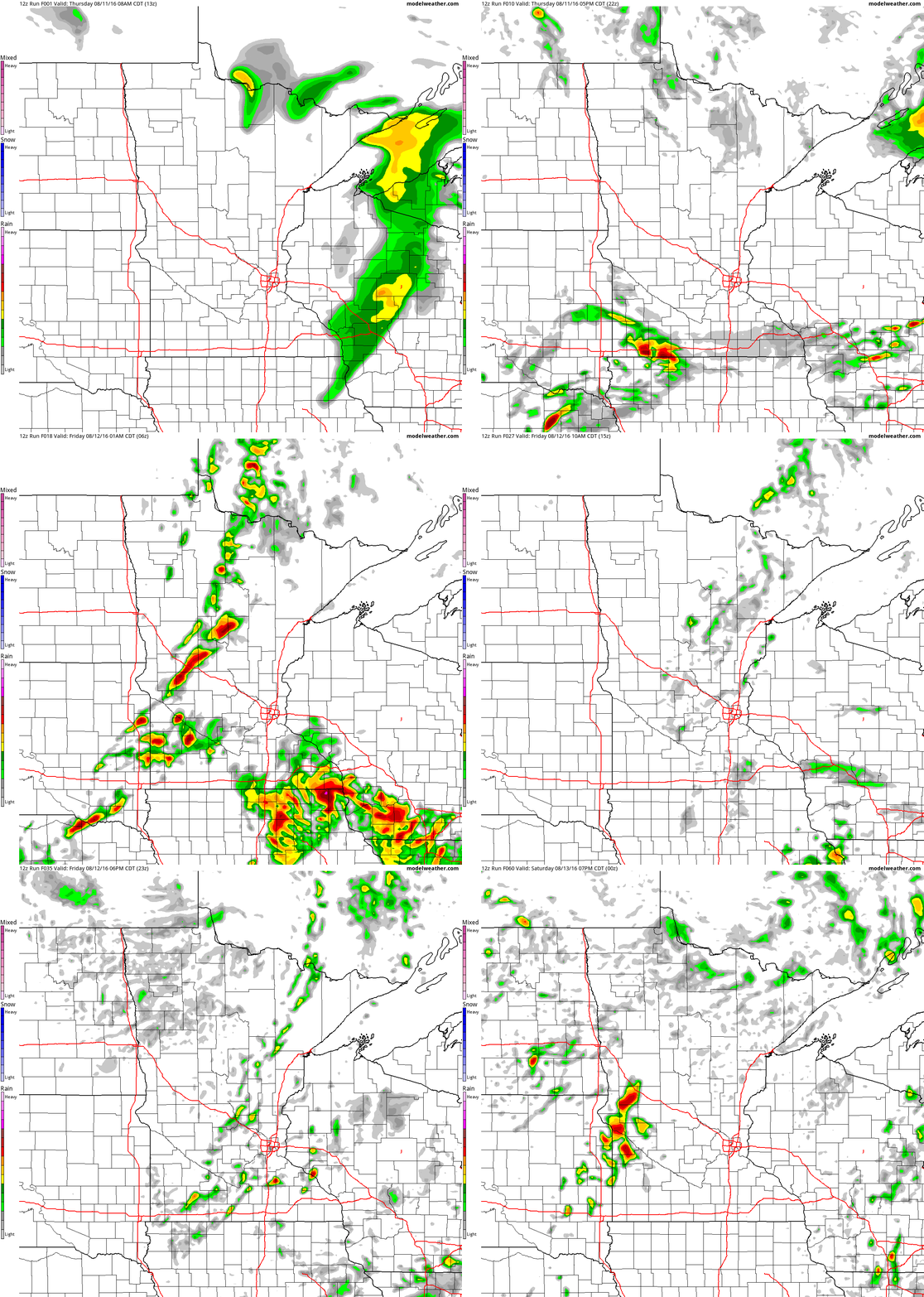
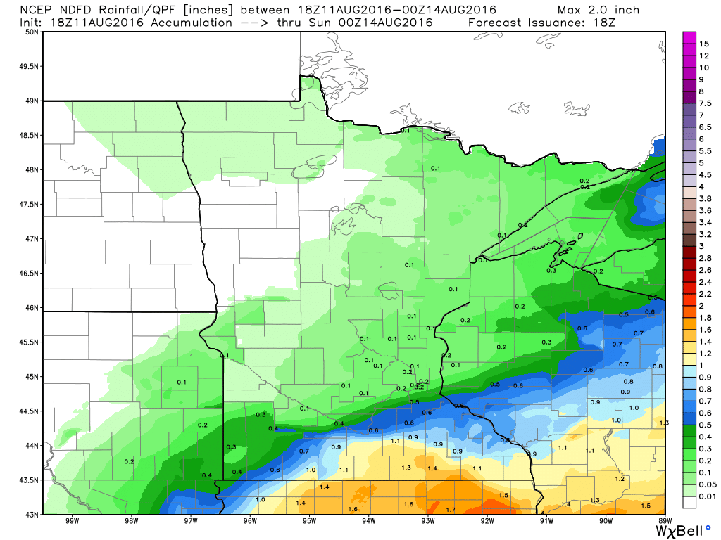
Rainfall Potential
Additional rainfall potential through 7PM Saturday suggests the heaviest rainfall moving south of the region by Friday. No additional rainfall is expected this weekend.
_____________________________
National Weather Outlook
The heavy rainfall that we had across the Upper Midwest earlier this week will begin to sag south through the end of the week and settle across the Southern U.S. through the Northeast over the weekend. This slow moving front will allow tropical moisture to align itself along it, which ultimately could produce several inches of rain and flood potential through early next week.
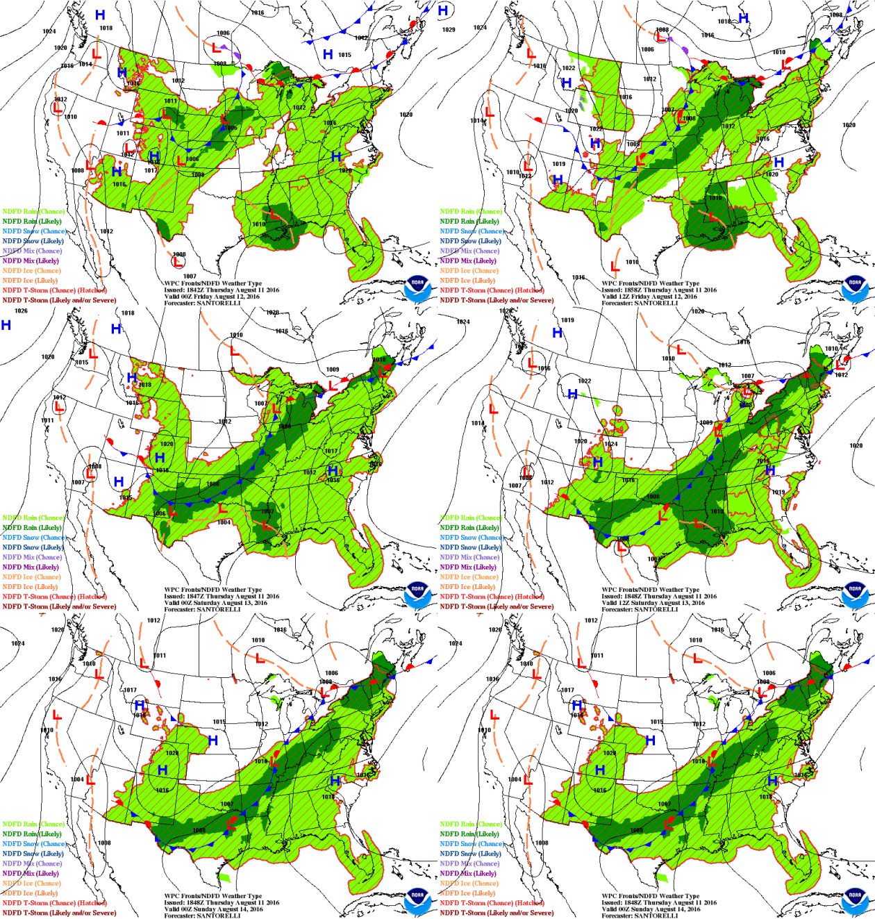
According to NOAA's WPC, the 5 day rainfall forecast shows significant rainfall potential from the Southern U.S. through the Ohio Valley and into the Northeast through early next week. Some spots across the Central and Southern U.S. could see as much as 4" to 8"+, which could lead to areas of flooding.
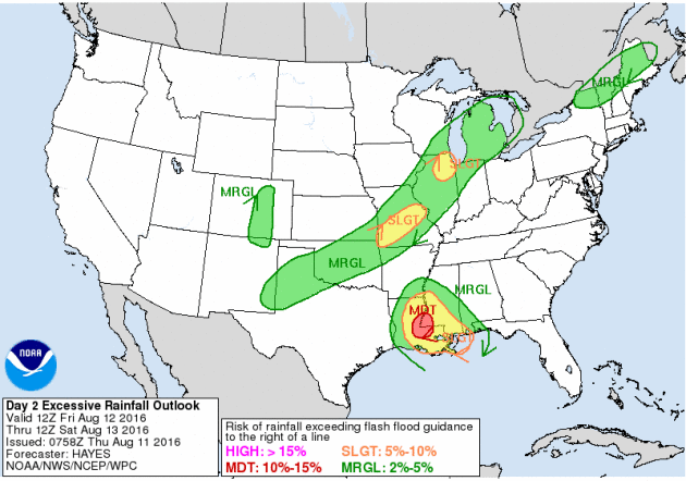
Excessive Rainfall Potential Friday
Here's a fairly new product from NOAA's WPC that suggests where flooding rains will be possible. Note that the best potential for flooding rains on Friday look to be in two main areas. The first in the Lower Mississippi Valley in a association with an area of low pressure that has been plaguing the Gulf Coast States since last weekend with heavy rain and flooding. The other area is along a front from the Great Lakes to the Southern U.S.
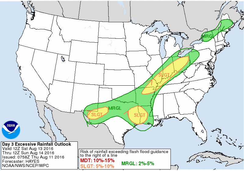
Excessive Rainfall Potential Saturday
Excessive rainfall will be possible once again on Saturday in some of the same areas, however the front looks to push a little farther south and east, which will line the heavy rain threat up in the Ohio Valley.
_______________________________________
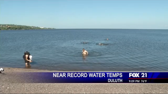
Near Record Warmth for Lake Superior
"The water was measured at 70 degrees Fahrenheit at around 4:30 p.m. Tuesday afternoon. The water temperature has been around six degrees warmer than on average. "I wouldn't say you could ever expect it to be this warm but I can change really fast," said Jesse Schomberg, extension educator with the University of Minnesota Sea Grant. The average temperature has continued to rise two degrees Fahrenheit every decade and even thought it's trending higher, researchers say high temperatures aren't normal. Researchers have found that Lake Superior is warming faster than almost any other lake in the world. "It's warming fast," said Schomberg. Research points towards climate change as being the biggest culprit for the higher water temperatures."
____________________________________________
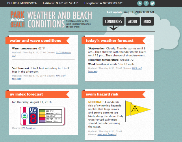
Current Park Point Conditions
Interested in what the weather conditions are like at Park Point in downtown Canal Park? Here you go!
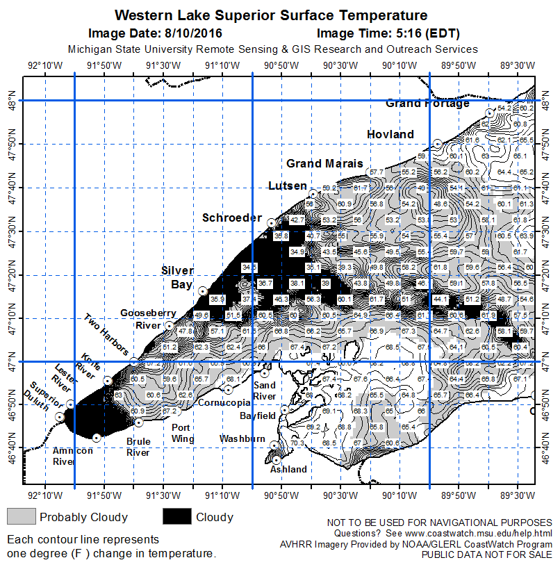
Current Lake Superior Water Temps
Keep in mind that the average temperature of Lake Superior is 40F. Even though surface water temperatures are in the 50s, 60s and 70s in a few spots, there a lot of water below the surface that it is COLD COLD water!
______________________________________
"‘Let’s get some perspective': Researchers say species face bigger threats than climate change"
"Tackling climate change is the challenge of the century. But when it comes to endangered wildlife, scientists are arguing that we’ve got more pressing matters to worry about. A new comment just out today in the journal Nature contends that practices like hunting, fishing and agriculture are still the biggest threats to biodiversity on Earth — and we need to be careful not to let our concern about climate change overshadow our efforts to address them. To be clear, the comment merely reflects the personal opinions of the scientists who wrote it. But they did do their homework to help back up their claims. The group, which included experts from the University of Queensland and the International Union for Conservation of Nature (IUCN), analyzed the threats facing more than 8,000 species on the IUCN’s Red List, a list of threatened animals, plants and other organisms all over the world. The IUCN classifies these organisms according to how severe their possibility of extinction is — categories include “critically endangered,” “endangered,” “vulnerable” and “near threatened.” Organisms facing the lowest possible risk of extinction are classified “least concern.”"
An elephant in Hwange National Park in Zimbabwe. (AP Photo/Tsvangirayi Mukwazhi)

__________________________________________
Thanks for checking in and have a great weekend ahead! Don't forget to follow me on Twitter @TNelsonWX


No comments:
Post a Comment