Eclipse Play-By-Play
"meteorologist Mark Elliot goes through a simulation of experiencing the total solar eclipse on Aug. 21 from the perspective of an observer on the ground. As a science editor for Mashable, I know the ins and outs of what causes an eclipse, and how dark it will get if you are in the path of totality, which on Monday will cut a narrow swath from Oregon to South Carolina. However, even I was impressed by how otherworldly the sky will appear at the time of the total solar eclipse, and how many intricate details will be revealed, about the moon and the sun, during a several-minute period on Monday. So, before looking up — with proper eyewear protection — on Monday, take a look at this clip first. And get psyched."
Great American Eclipse - Solar Eclipse Monday
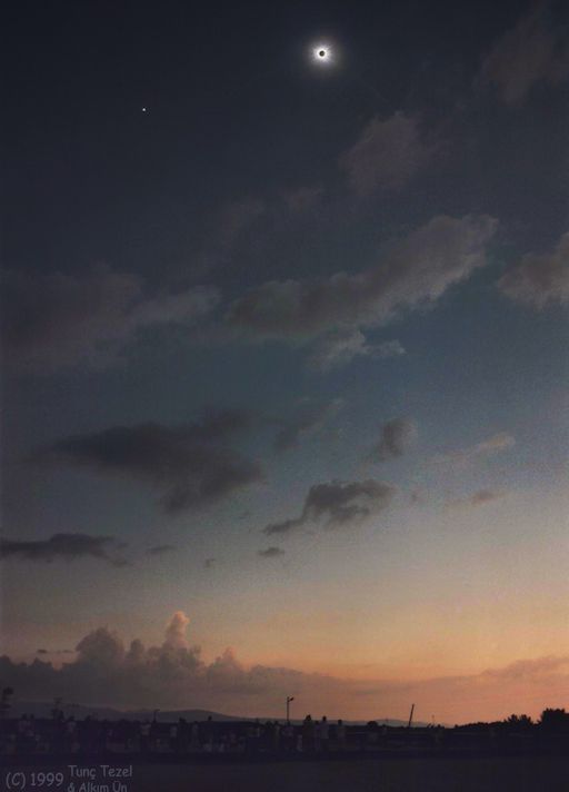
WHY GO TO THE PATH OF TOTALITY? On Aug. 21, 2017, every square inch of the USA will experience a solar eclipse. In most places, the eclipse will be partial--that is, the Moon will cross the sun off-center leaving only a crescent-shaped portion of the solar disk exposed. Is it really worth the trip to the path of totality when you can see most of the sun covered from the comfort of your own home? Pulitzer prize winner Annie Dillard witnessed both types of eclipse in 1979, and her comparison might help you make up your mind: "A partial eclipse is very interesting. It bears almost no relation to a total eclipse. Seeing a partial eclipse bears the same relation to seeing a total eclipse as kissing a man does to marrying him, or as flying in an airplane does to falling out of an airplane." During the minutes of totality, the whole world changes. Saying that day turns into night barely scratches the surface of it. The shadow of the Moon lances down to Earth from a quarter million miles away. On one end is you; on the other end is a million square miles of dusty lunar terrain. You're connected, and you can feel the cold.
((Image Credit & Copyright: Tunç Tezel (TWAN), Alkim Ün via SpaceWeather.com)
Total Solar Eclipse Interactive Map
Want to know the timing of the solar eclipse across the country? Here's a great interactive map from NOAA that can help! For example, the green marker near Hopkinsville, KY shows the point of "Greatest Eclipse" with the total eclipse lasting 2minutes and 40seconds and the maximum eclipse occurring at 18:25 UTC or 1:25pm CDT.
Cloud Forecast: Midday Monday
Here's the cloud forecast for midday Monday, which shows a blob of clouds over the Central US. Unfortunately, there may be cloud issues in the Central US for folks trying to catch the total solar eclipse there. Stay tuned...
"The car-traffic apocalypse of the total solar eclipse has begun"
The total solar eclipse of August 21 is almost upon the US. Approximately 7.4 million Americans may travel to the path of totality, where the moon's darkest shadow will cut across the country. But this mass migration may overwhelm small towns and cities with record tourism — and choke key roadways with gridlock traffic. That's according to an analysis by Michael Zeiler, a cartographer at the mapping data and technology company Esri, and an eclipse chaser of 26 years. "People should not casually expect to drive down on the morning of the eclipse," Zeiler told Business Insider. In Oregon, which will be the first US state to see the moon blot out the sun, it seems the mass influx of vehicles for the eclipse may have already begun. A video taken on Wednesday by a frustrated-sounding central Oregon resident, which KAPP-KVEW Local News posted to its Facbook page, shows a line of cars that stretches for all 4 minutes and 32 seconds of the video, and for about 4 miles of roadway. "This is all heading into Prineville on a Wednesday, all the way up the mountain," she said in the video, which she recorded around 11:32 a.m. PDT. "There is no accident. This is all for the lovely eclipse that is happening, and everyone trying to get into their camping spots." She added: "Luckily, I'm heading the other direction. ... The cars next to us are going roughly 5 miles per hour, if not completely stopped."
(Image credit: Shutterstock via BusinessInsider)

"Soul-crushing traffic may plague the total solar eclipse — these maps reveal the worst choke points"
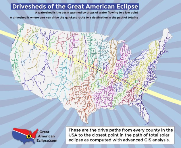
Monday's total solar eclipse will be the first to slice across the US in 99 years, inspiring many Americans to pack up the car and drive to totality: the path of the moon's darkest shadow. In fact, up to 7.4 million people may journey to the 70-mile-wide, 2,800-mile-long track where the moon will block the sun and reveal the star's wispy corona. That's according to Michael Zeiler, a cartographer at Esri, a mapping data and technology company. Zeiler has anticipated this moment since he started chasing eclipses 26 years ago. He has spent the past few years gathering data, plotting maps of the eclipse (and its surprising ramifications), and uploading them to his website, GreatAmericanEclipse.com. Zeiler considers his "driveshed" maps some of his favorites. Like watershed maps that show how brooks, streams, and rivers move toward an ocean, his version shows where vehicles are most likely to flow toward a viewing location. "I thought about about every populated point in the United States, and I asked the data: What is the quickest drive to totality?" Zeiler told Business Insider. "I discovered there's going to be about one or two dozen traffic-congestion points that are going to be particularly severe." Here are the 12 biggest drivesheds Zeiler has identified, the cities they center on, and — by extension — the places most likely to be choked with gridlock traffic.
Tornadoes in Southwest Minnesota Friday Evening
A line of strong to severe thunderstorms developed Friday evening across eastern South Dakota and dropped southeast into Southwest Minnesota with a number of large hail and wind damage reports. There was even a report of a tornado, which was caught and camera and shared to the @NWSSiouxFalls. This particular tornado reportedly destroyed a hog barn.


Tornado Damage and Large Hail
The National Weather Service in Sioux Falls, SD confirmed 4 tornadoes on Friday evening. Here are some images from the @NWSSiouxFalls of tornado damage out of Melvin, IA and large hail that fell in Bigelow, MN.
Storm Report Map From Friday Evening
The storm report map from Friday evening shows large hail and damaging wind reports stretching from eastern South Dakota through SW Minnesota and into NW Iowa.
All 4 Tornadoes Confirmed by NWS Sioux Falls
_____________________________________________________________
Severe Threat Sunday and Monday
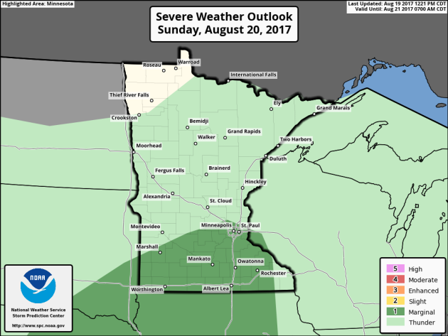
According to NOAA's SPC, there is a MARGINAL risk of severe weather across the southern part of the state on Sunday. By Monday, the MARGINAL risk of severe weather shifts a little farther south and moves into extreme southern Minnesota.
.png)
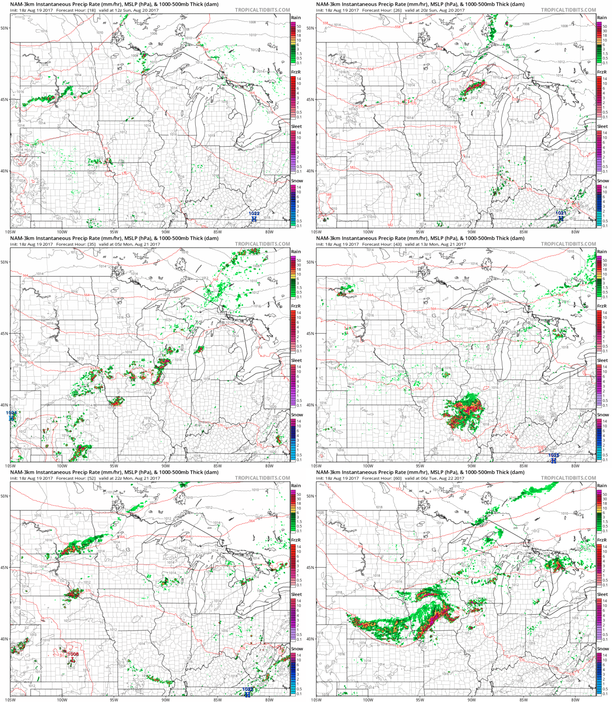
Simulated Radar Ahead...
Here's the simulated radar from Sunday to Monday night, which shows a few isolated showers/storms trying to develop across the region both days. However, it doesn't appear to be very widespread, so significant rainfall and severe threats should remain fairly minimal.
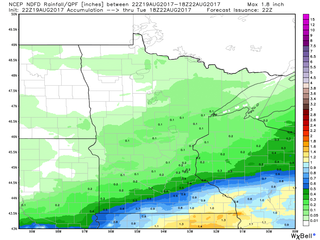
Rainfall Potential Ahead
_________________________________________________________
The rainfall forecast through PM Monday shows a better chance of locally heavier rainfall amounts across extreme southern and southeastern Minnesota, where some 0.50" to 0.75"+ amounts can't be ruled out.

_________________________________________________________
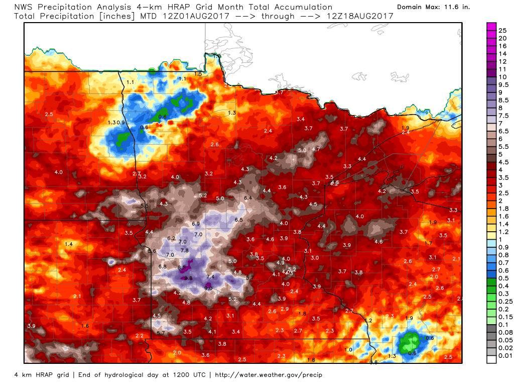
Rainfall Month To Date
It has been a pretty wet month thus far with the Twin Cities seeing 4.53" of rain through August 18th! That is nearly 2" above average for the month! Note that some locations in western Minnesota have seen nearly 7" to 9"+ of rain! So far this year, the Twin Cities has seen 23.43" of liquid precipitation, which is nearly 3" above average.
Precipitation Year to Date
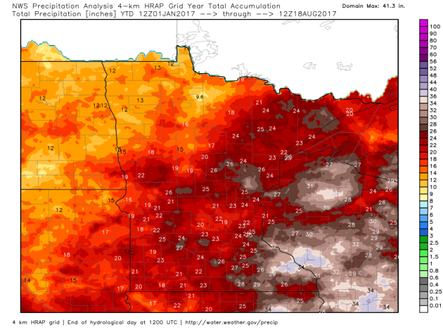
Here's a look at how much precipitation we've seen so far this year. Note that precipitation amounts are quite a bit higher as you go east into Wisconsin, while precipitation amounts fall considerably as you head west into the Dakotas. La Crosse, WI has seen nearly 31.57" of precipitation this year, which is 9.31" above average! However, Fargo, ND has seen only 10.44" of precipitation this year, which is -4.39" below average, while Minot, ND has seen only 5.33" of precipitation this year, which is 7.27" below average!
US Drought Monitor
While much of the state has had appreciative rainfall this month and so far this year, parts of western and northwestern Minnesota are dealing with moderate drought and abnormally dry conditions. According to the US Drought Monitor, 18.26% of the state is considered to be in a moderate drought, which is up from 17.41% last week. Note that 3 months ago, 0.00% of the state was in a moderate drought and only 0.51% was considered to be abnormally dry.
______________________________________________________
Beautiful Saturday
Despite seeing a little fog on Saturday morning, it turned out to be an incredible day with mild temps and plenty of sunshine. Note that the average high in the Twin Cities has fallen to 80F, so as we head closer and closer to the Autumnal Equinox (September 22nd @3:02pm), the number of days with extreme heat and high humidity will begin to fade a little bit.
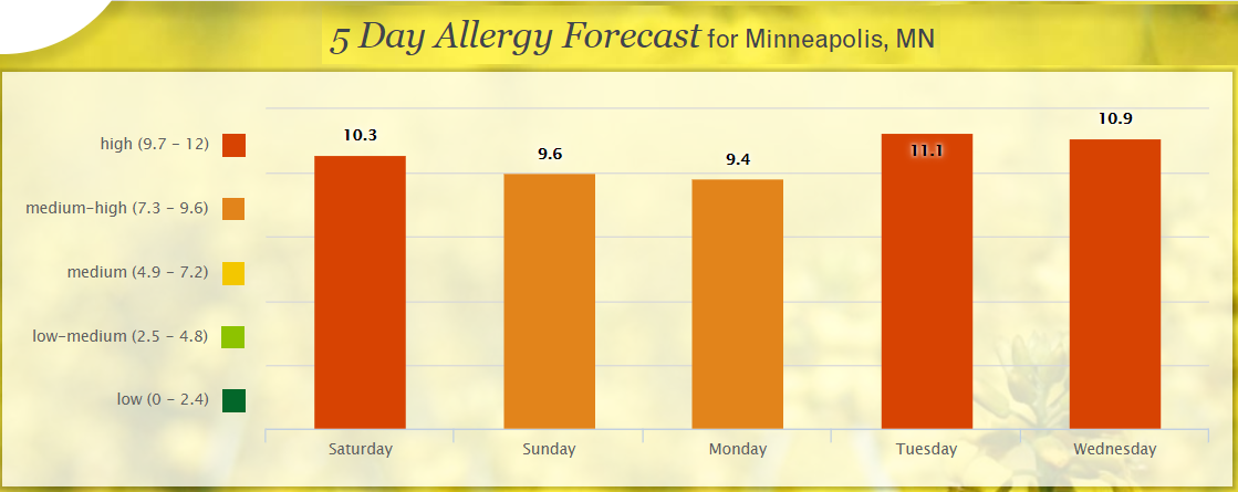
Pollen Forecast
Itchy, sneezy? I tend to get a little more allergic to fall and I notice it more and more starting around State Fair time, which then finally starts to fade as the first frosts of the season start to arrive. With that said, according to pollen.com, the allergy forecast for Minneapolis suggests high to medium-high levels over the next few days. AHHH-CHOOO!!!
__________________________________________________________________
Northern Lights
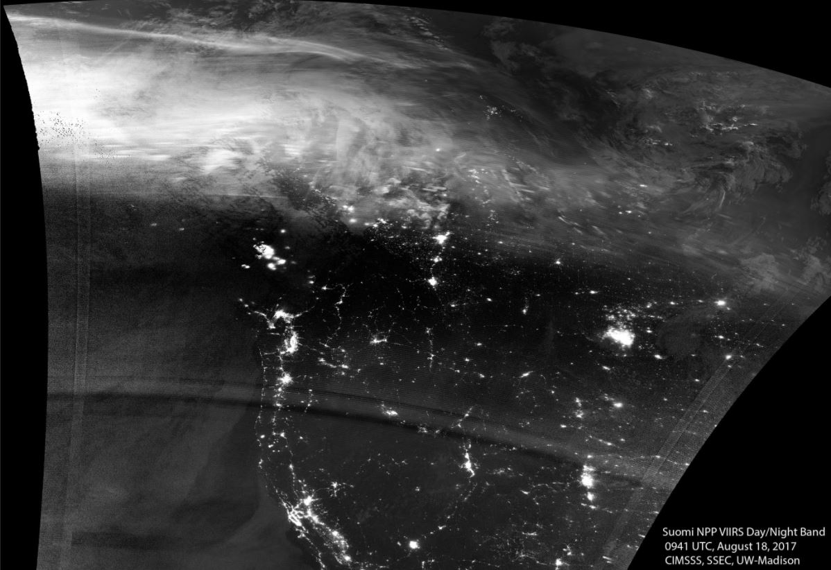
WOW! Take a look at this image from @UWCIMSS, which shows aurora across Canada! This image was captured Friday evening from space!

Northern Lights Forecast Sunday
According to the Geophysical Institute at the University of Alaska Fairbanks, the aurora forecast for Sunday suggests a fairly active pattern. Note that northern lights could be seen as far south as Vancouver, Great Falls, Pierre, Madison, Lansing, Ottawa, Portland and St. Johns!!
___________________________________________________________________________
HARVEY in the Atlantic
The National Hurricane Center is tracking HARVEY in the Atlantic basin, which became the 8th named storm of the 2017 season. This storm will continue to drift west through the Caribbean and eventually toward the Yucatan Peninsula by the early/middle part of next week.
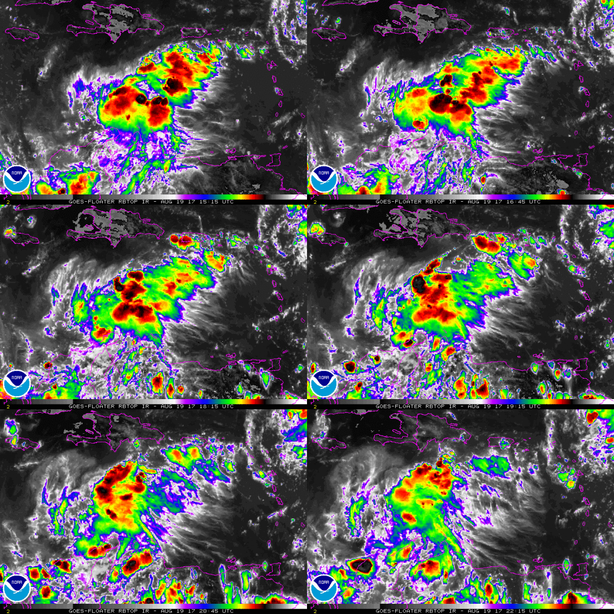
Here's the official track for HARVEY, which shows it briefly down to tropical depression strength before becoming a tropical storm again late weekend. Over the next few days, it should drift towards the Yucatan Peninsula, but stay below hurricane status. Stay tuned...