- 10.9" - Near Scanlon
- 10.6" - NWS Duluth
- 10.3" - Finland
- 10.1" - Holyoke
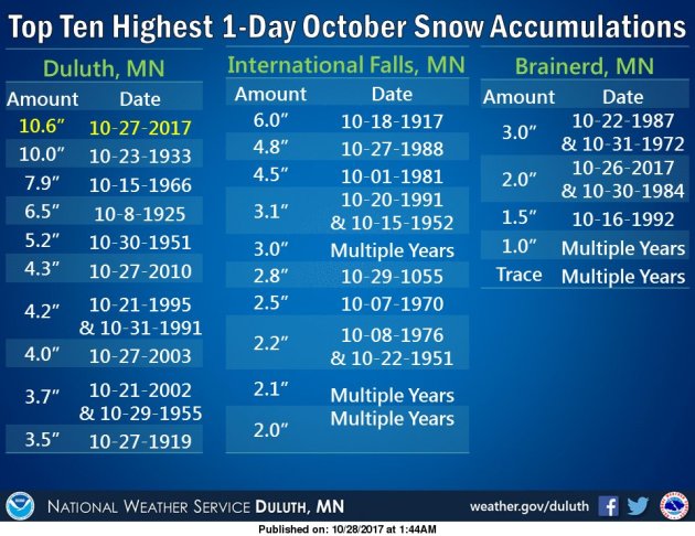

So why did the storm produce more snow than expected? NWS Duluth meteorologist Carol Christenson gave an interview to the Duluth News Tribune answering that very question: "Christenson said forecasters knew there was going to be a lot of snow in the Arrowhead region with this storm, but the Duluth area got more than anticipated because of a lifting effect. Strong winds coming off of Lake Superior were forced upward — called orographic lifting — creating more snow and pushing it into higher elevations in areas such as Duluth Heights, Proctor, Hermantown and parts of Carlton County. Cold winds rolling over the relatively warm waters of Lake Superior probably contributed to more snow, along with rain changing to snow earlier than anticipated."
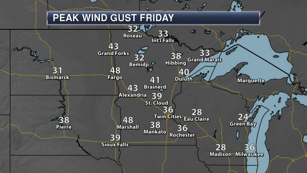
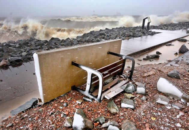
These strong winds helped to whip up large waves on Lake Superior, which ended up doing damage along the lake shore in Duluth. Damage was reported along the lakewalk, at Brighton Beach and at Glensheen. Much more on the damage can be found from the Duluth News Tribune: "Sections of Lakewalk boardwalk were dislodged and tossed about by the waves, and much of the path was covered by rocks and other debris. The city closed the Lakewalk from Endion Station to and including the Portland Malt Shoppe stairway until further notice because of the damage, and there were barriers up because of additional damage near 16th Avenue East."
_______________________________________________
Light Rain Showers Today - Werewolf Watch Issued
By Paul Douglas
Here in the Land of Low Weather Expectations 32F feels considerably worse in October than it does in March. The first snow sparks irrational fear. It's the cold storms, snow falling at temperatures colder than 15F, that make me nervous - when chemicals can't effectively melt the snow and ice.
According to Sperling's Best Places, which analyzed natural disaster data, the Twin Cities is the 7th safest large metro area in the USA. Only cities like Salt Lake City and Portland are safer. We see a tornado from time to time, but nothing like the southern USA, where tornadoes, hurricanes & floods mean the highest risk cities are Oklahoma City and Austin to Miami. Feeling better? It was worth a shot.
The atmosphere should be just warm enough aloft for rain showers today. Flurries race past your window tomorrow, with a harsh breeze and 30s. Winds ease up a bit Halloween with some sun, but it will be chilly.
ECMWF (European) guidance shows the jet stream buckling, pumping mild air north by early next week. Before we're knee-deep in snow we will see more 50s, which will feel very good.
_______________________________________________
Extended Twin Cities Forecast
SUNDAY: Light rain showers. High 45. Low 33. Chance of precipitation 70%. Wind SW 8-13 mph.
MONDAY: Cold wind, passing flurries. High 39. Low 27. Chance of precipitation 40%. Wind NW 15-25 mph.
TUESDAY: Some sun, risk of a vampire. High 41. Low 30. Chance of precipitation 10%. Wind SW 7-12 mph.
WEDNESDAY: Overcast & windy, risk of a shower. High 44. Low 35. Chance of precipitation 30%. Wind S 10-20 mph.
THURSDAY: More clouds than sun. High 46. Low 32. Chance of precipitation 20%. Wind NW 8-13 mph.
FRIDAY: Another chance of rain showers. High 42. Low 34. Chance of precipitation 60%. Wind NE 8-13 mph.
SATURDAY: Mostly cloudy, shower or sprinkle? High 48. Low 38. Chance of precipitation 40%. Wind SE 8-13 mph.
_______________________________________________
This Day in Weather History
October 29th
2004: Exceptionally muggy conditions for October are felt over much of the state. Dew points surged into the middle to upper 60's over central and southern Minnesota. Ladybugs are extremely active.
1955: Early snow hits the Twin Cities, accumulating to 2.2 inches.
1905: Several inches of snowfall accumulate in south central Minnesota. Snow totals included 7 inches at Fairmont, 6 inches at Farmington, 4.5 inches at Montevideo, 4 inches at Faribault, and 3 inches at New London.
_______________________________________________
Average Temperatures & Precipitation for Minneapolis
October 29th
Average High: 52F (Record: 78F set in 1922)
Average Low: 35F (Record: 15F set in 1925)
Average Precipitation: 0.06" (Record: 1.01" set in 1896)
Average Snow: 0.1" (Record: 5.5" set in 1905)
________________________________________________
Sunrise/Sunset Times for Minneapolis
October 29th
Sunrise: 7:47 AM
Sunset: 6:05 PM
*Length Of Day: 10 hours, 17 minutes and 16 seconds
*Daylight Lost Since Yesterday: ~2 minute and 50 seconds
*Latest Sunrise Before Daylight Saving Time Ends: November 4th (7:56 AM)
*Next Sunset At/Before 6:00 PM: November 1st (6:00 PM)
_______________________________________________
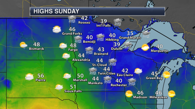
Minnesota Forecast
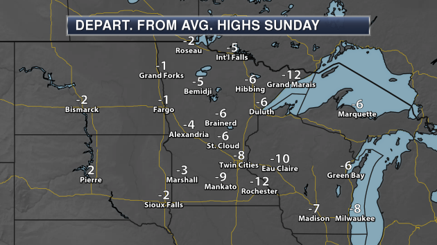
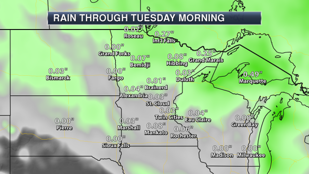
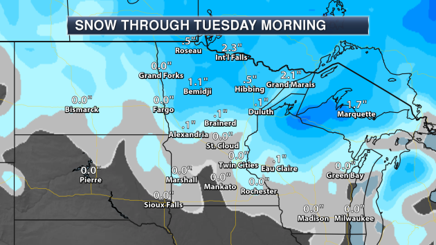
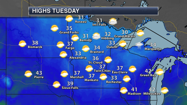
_______________________________________________
National Forecast Highlights
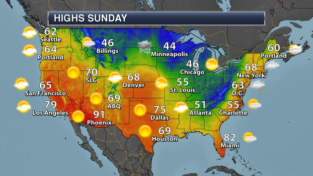
A
cold front will continue to push east as we head through the day
Sunday, bringing cooler weather along with it by Monday to the east
coast. However, a coastal low will also develop, bringing the Northeast
heavy rain throughout the day and strong winds by Sunday night. Another
system across the upper Midwest will bring the chance of rain and snow
to the region. While some rain and snow will also be possible with a
cold front dropping south across Montana and Wyoming, the rest of the
west will be under high pressure.
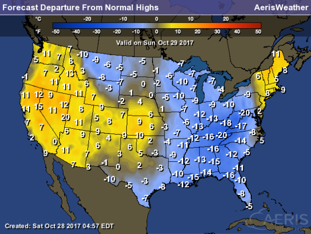
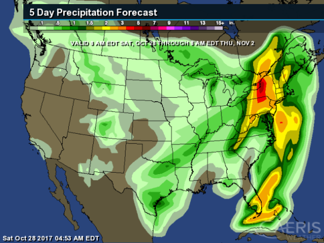
The
heaviest rain through Thursday morning will be across the Northeast,
where some areas could pick up to 6" of rain Sunday into Monday with a
coastal low moving through the region. I'll have more on that in just a
moment.
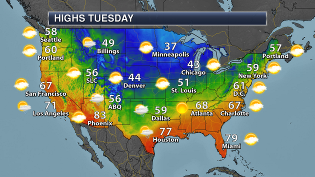
Looking
ahead to Halloween on Tuesday, most of the nation looks to be dry
during the day. The best chance of rain looks to be across parts of the
Southwest and the Southern Plains.
_______________________________________________
EXCERPT From Praedictix Briefing On Eastern Coastal Low From Saturday Morning:
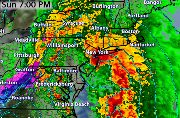
Coastal Low This Weekend.
A strong coastal low is expected to form along the East Coast this
weekend as a cold front continues to move east. This system will tap
into deep tropical moisture, allowing for the potential of heavy rain.
Also, as the storm quickly strengthens and moves northward, damaging
winds capable of tree damage and power outages can be expected Sunday Night into Monday across the Northeast.
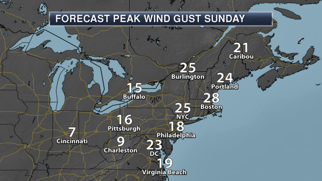
 Peak Wind Gusts Sunday. Winds
will be on the increase during the day Sunday, with wind gusts in the
20 mph range from Caribou to Washington D.C. expected.
 Peak Wind Gusts Sunday Night. Some of the highest wind gusts are expected Sunday Night into Monday
across the Northeast as the system strengthens. Some areas of the
Northeast could see wind gusts that approach 60 mph, with the strongest
winds expected along the coast and in higher-terrain areas. These winds
will be capable of tree damage and power outages, and cause delays at
the major airports across the region.
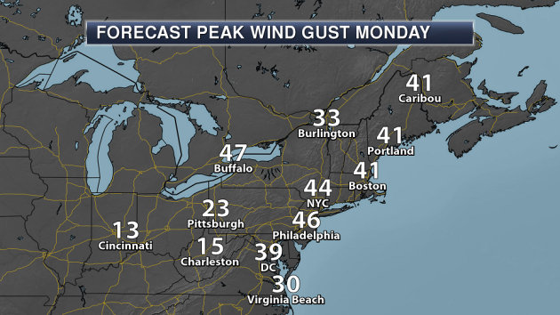
 Peak Wind Gusts Monday. Winds
will continue to be strong due to this system across the region into
Monday – especially during the first half of the day - with many areas
continuing to see wind gusts in the 40 mph range.
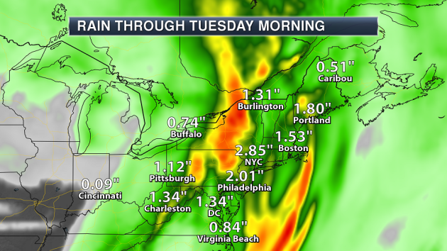
 Heavy Rain Concerns.
This system will have deep tropical moisture available to it – some of
which will come from Potential Tropical Cyclone 18 - that it will tap
into starting Sunday and lasting into Monday.
Widespread amounts of 2-4" can be expected, with isolated higher totals
of 6" or more. This could lead to flash flooding across the region.

_______________________________________________
"Beyond Hurricane Harvey" In Houston
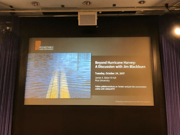
Meteorologist Matt Lanza attended a discussion called "Beyond Hurricane Harvey" Tuesday. He wrote about the discussion in the Space City Weather blog: "On
Tuesday evening, just as the Astros took the field for game one in Los
Angeles, I had the pleasure of attending a Baker Institute event at Rice
University featuring Dr. Jim Blackburn. “Beyond Hurricane Harvey” was a
discussion and Q&A with Blackburn, who is the co-director of the
Severe Storms Prevention, Education, and Evacuation from Disaster
(SSPEED) Center at Rice. During Tuesday’s event, Blackburn basically
laid out his vision for how we need to discuss and tackle Houston’s
flooding problem from this point forward. Many of these ideas were
incorporated by Harris County Judge Ed Emmett in the plan that he
unveiled on Wednesday. Nevertheless, here is a summary and some of my
takeaways from Tuesday’s event." (Image: Tuesday night’s event was
held at the Rice University Baker Institute by their young professionals
group. (Matt Lanza))
A Rainless October In Tucson
Tucson has received no rain so far this month. It looks like it may only be the fifth October on record with no rain. More from the Arizona Daily Star: "It
appears October will wind up as a dry month, with no rain in sight in
Tucson’s metropolitan area for at least a week — maybe more. Since 1948,
there have been four times Tucson received no rainfall during October —
1952, 1973, 1982 and 2013, said Jordan Pegram, a National Weather
Service meteorologist. This year’s dry stretch could potentially hit two
months: Sept. 8 was the last time the city recorded measurable rain at
Tucson International Airport. A whole 0.03 of an inch fell."
Lemurs Starving Due To Climate Change

A new study shows that lemurs are starving in Madagascar due to climate change. More from Scientific American: "Even
though it is already the most endangered primate in the world, the
greater bamboo lemur just can’t catch a break. Climate change is
starving out this Madagascar native, a study published Thursday reports
in Current Biology. These critically endangered lemurs nibble almost
entirely on the tender shoots of one bamboo species. But during the dry
season, which is normally from August to November, the lemurs switch to
the bamboo’s culm–the more readily available but nutrition-less woody
trunk. Scientists anticipate as climate change continues to stretch out
the dry season, the lemurs will be forced to eat this unappetizing culm." (Image: Greater Bamboo Lemur. Credit: David Cayless Getty Images)
______________________________
Thanks for checking in and have a great Sunday! Don't forget to follow me on Twitter (@dkayserwx) and like me on Facebook (Meteorologist D.J. Kayser)!
- D.J. Kayser

- D.J. Kayser
Togel Online
ReplyDeleteBandar Togel Terpercaya
Judi Togel
Agen Togel
Cannabinoids validcbdoil affect the endocannabinoid system in your body. The endocannabinoid system helps maintain the nervous system and immune function on an even keel.
ReplyDeleteis it a Blizzard that's bad enough to make it hard to go outside?
ReplyDeleteOnline bookmakers provide a good opportunity to participate in popular sports, as well as bambet ghana various leagues and tournaments from around the world. Convenient platforms, extensive event lists and quick access points make the process of sports betting very simple and convenient for each individual user.
ReplyDelete