80s In Late October!
The
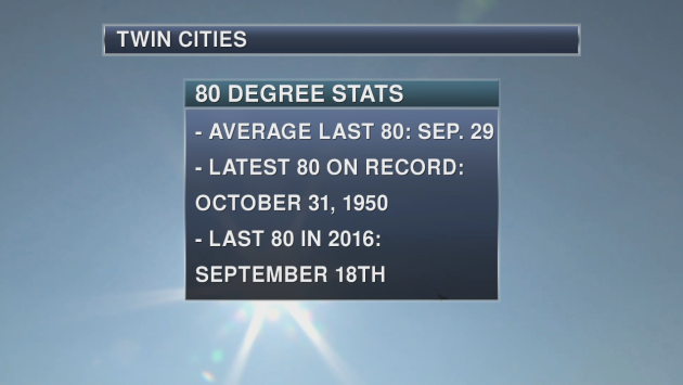
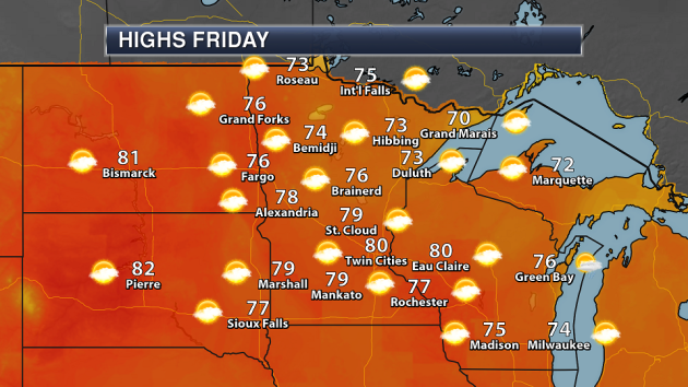
forecast high right now for Friday is 80 in the Twin Cities! If the
Twin Cities did hit 80 on Friday, it would be one of the latest last 80s
on record as only ten other years have had a later date that the last
80 occurred on. The last average 80 on record (looking over the entire
Twin Cities record) occurs on September 29th. Meanwhile, it was quite a
warm Halloween in 1950 as that is the date of the latest 80 on record.
Last year, the last 80 was on September 18th. The last time we saw a
high that was 80 or higher this year was back on September 24th when the
high reached 90.
_______________________________________________
August In October With A High Of 80 Today!Who’s ready to get a natural sun tan in late October?
After a beautiful week of weather so far, today looks to potentially be the best day of the stretch – if you don’t mind breezy weather, that is. Highs will climb into the upper 70s to around 80 later this afternoon on the back of mainly sunny skies and southerly winds that’ll gust up to 30 mph.
To put today into perspective, it’s not often that we hit 80 this late in the year. Even though the record for the day is 83 set in 1953, if we reached 80 today in the Twin Cities it would be the eleventh latest last 80 degree day on record!
Unfortunately, this nice stretch of weather comes to an end this weekend. A cold front brings showers and storms for Saturday, along with cooler conditions. A second front early next week ushers in highs that will finally be back around average for late October.
Make an effort to get out and enjoy the weather today. There's probably a good chance we won't see weather this nice again until next spring.
_______________________________________________
Extended Twin Cities Forecast
FRIDAY: Warm and windy. High 80. Low 61. Chance of precipitation 10%. Wind S 10-25 mph.
SATURDAY: Cooler with showers and thunderstorms. High 69. Low 46. Chance of precipitation 80%. Wind S 10-15 mph.
SUNDAY: Sunny skies. Highs still above average. High 62. Low 46. Chance of precipitation 10%. Wind NW 3-8 mph.
MONDAY: A few afternoon showers. High 62. Low 43. Chance of precipitation 30%. Wind SW 5-10 mph.
TUESDAY: Breezy with cooler temperatures. High 52. Low 36. Chance of precipitation 20%. Wind NW 10-15 mph.
WEDNESDAY: Frosty start. Cool sunshine. High 54. Low 40. Chance of precipitation 10%. Wind NW 5-10 mph.
THURSDAY: A few clouds. Highs around average. High 54. Low 39. Chance of precipitation 10%. Wind SW 5-10 mph.
_______________________________________________
This Day in Weather History
October 20th
October 20th
2002:
Heavy snow impacts central Minnesota. It fell in a 10-20 mile wide band
from southeast North Dakota to around Grantsburg, Wisconsin. Little
Falls picked up 9 inches.
1916:
Accumulating snow falls in south central Minnesota with 4.5 inches
recorded in New Ulm, 4 inches in Farmington and Hutchinson, 3.5 inches
in Montevideo, and 3 inches in Faribault.
1835: 6 inches of snow falls at Ft. Snelling.
_______________________________________________
Average Temperatures & Precipitation for Minneapolis
October 20th
October 20th
Average High: 56F (Record: 83F set in 1953)
Average Low: 38F (Record: 18F set in 1960)
Average Precipitation: 0.07" (Record: 2.64" set in 1934)
Average Low: 38F (Record: 18F set in 1960)
Average Precipitation: 0.07" (Record: 2.64" set in 1934)
________________________________________________
Sunrise/Sunset Times for Minneapolis
October 20th
October 20th
Sunrise: 7:35 AM
Sunset: 6:19 PM
Sunset: 6:19 PM
*Length Of Day: 10 hours, 43 minutes and 28 seconds
*Daylight Lost Since Yesterday: ~2 minute and 58 seconds
*Daylight Lost Since Yesterday: ~2 minute and 58 seconds
*Latest Sunrise Before Daylight Saving Time Ends: November 4th (7:56 AM)
*Next Sunset At/Before 6:00 PM: November 1st (6:00 PM)
*Next Sunset At/Before 6:00 PM: November 1st (6:00 PM)
_______________________________________________
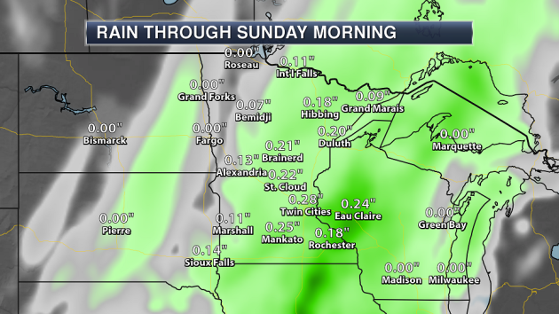
Minnesota Weather Outlook
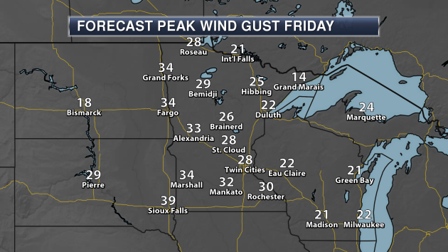
It
will be quite a windy day on Friday as well, however, as winds gust
over 30 mph across portions of central and southern Minnesota. That will
be helping to usher in some of that warmer air, however.
_______________________________________________
National Weather Outlook
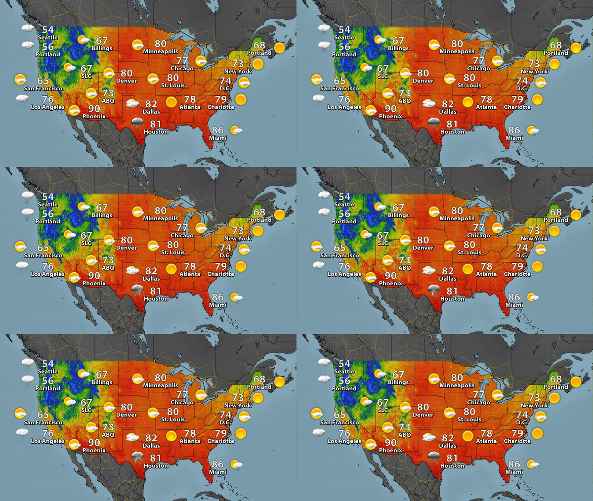
Rain
and snow will continue across parts of the Intermountain West on Friday
as a cold front continues to drive west. Meanwhile, onshore flow will
continue to bring the Pacific Northwest precipiation, along with a new
system pushing in by Friday Night. A slow moving front across Florida
will allow more showers and storms to soak the Sunshine State. The
middle and upper Texas coasts will see some thunderstorms as moisture
streams in ahead of a cold front that will move through the Midwest this
weekend.
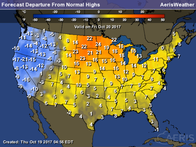
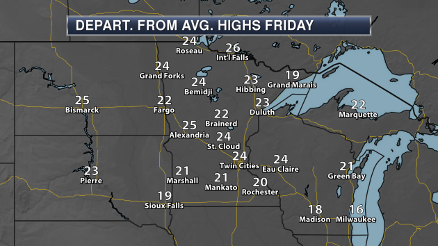
Highs
on Friday will be far above average for this time of year across parts
of the upper Midwest, with some areas a good 20-25 degrees above the
average. With a cold front continuing to move east, parts of the western
United States will see below average temperatures.
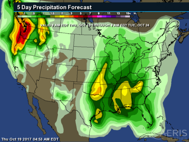
Heavy
precipitation will continue across the Northwest as we watch a number
of systems move through the region. Rainfall totals could top a half a
foot in spots through next Tuesday morning. Heavy rain of at least 2"
will also be possible across the Plains into the Southeast from this
weekend into early next week.
Rainfall
could quickly add up in the Northwest as we head into the weekend. The
forecast has Portland, OR, picking up almost five and a half inches of
rain through Sunday morning!
_______________________________________________
NOAA Winter Weather Outlook
NOAA
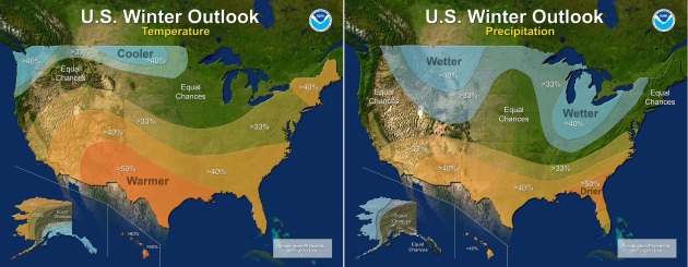
released their winter weather outlook Thursday morning, and the
forecast calls for wetter and cooler than average conditions across the
northern United States, but warmer and wetter conditions for southern
states. More from NOAA: "Forecasters
at NOAA’s Climate Prediction Center released the U.S. Winter Outlook
today, with La Nina potentially emerging for the second year in a row as
the biggest wildcard in how this year’s winter will shape up. La Nina
has a 55- to 65-percent chance of developing before winter sets in."
Heat In Bangladesh

World Hunger On The Rise
A recent U.N. report says that world hunger is on the rise again, and climate change has a hand in it. More from The Conversation: "Around the globe, about 815 million people – 11 percent of the world’s population – went hungry in 2016, according to the latest data from the United Nations. This was the first increase in more than 15 years. Between 1990 and 2015, due largely to a set of sweeping initiatives by the global community, the proportion of undernourished people in the world was cut in half. In 2015, U.N. member countries adopted the Sustainable Development Goals, which doubled down on this success by setting out to end hunger entirely by 2030. But a recent U.N. report shows that, after years of decline, hunger is on the rise again."
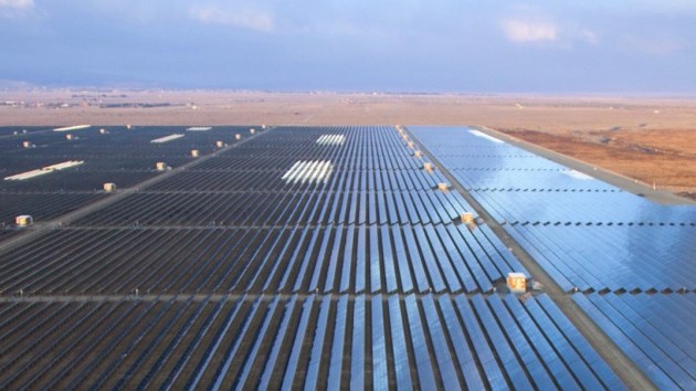
Solar Power, A California Town... And A Republican
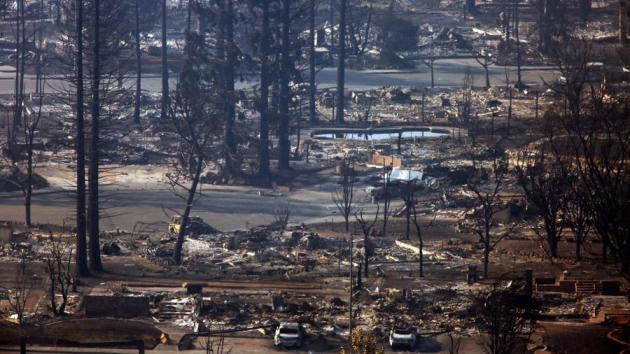
Wildfires, Hurricanes... The Climate Connection
Forest CO2 Emissions

______________________________
Thanks for checking in and have a great Friday! Don't forget to follow me on Twitter (@dkayserwx) and like me on Facebook (Meteorologist D.J. Kayser)!
- D.J. Kayser

- D.J. Kayser

No comments:
Post a Comment