 No more "threat of rain" or "risk of precipitation." Considering we're in a deepening drought we should probably adjust our verbiage to reflect dry lawns, cracking farmer's fields and brown, sunburned gardens. From now on we'll talk about an "opportunity for showers" or a "welcome round of storms." So long as we don't get blown away or pounded by beach-ball-size hail, that is.
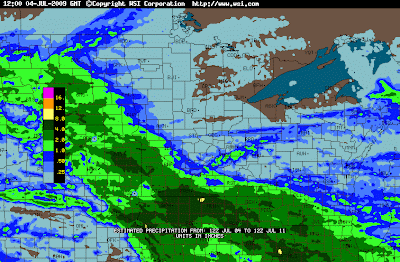
 Doppler-Estimated Rainfall last week, showing 1-4" rainfall amounts over much of southwestern and southern Minnesota, generally south of the Minnesota River, while no rain was reported near Duluth and the Minnesota Arrowhead. Drought conditions continue to expand across central Minnesota.
 Latest Drought Monitor. Note that 3 months ago only 16% of Minnesota was characterized as too dry. Now nearly 64% of the state is too dry, just under 17% of Minnesota counties reporting moderate drought conditions. Click here to see the latest drought monitor information, click on the USA to zoom into specific regions or individual states.
The silver lining: fewer severe storms, less hail, only 8 tornadoes so far statewide, and 7 of those were relatively feeble EF-0 twisters (the Austin tornado was a larger EF-2). Yes, there are some days it's a little bit chilly for the lake or pool, but if the sun is out 70-75 feels pretty good. And keep in mind it's just as easy to get sunburned at 70 as it is at 90. The potential to fry has nothing to do with temperature, and everything to do with sun angle, specifically: the date - how direct the sun's rays are overhead.
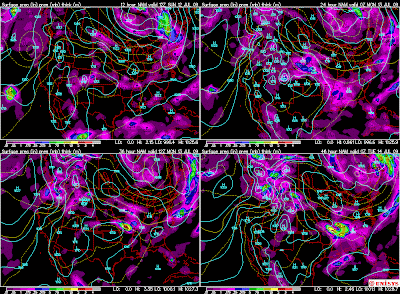
 4-Panel WRF/NMM model showing today's weak, almost clipper-like disturbance brushing Minnesota with light showers during the midday and afternoon. We dry out briefly on Monday before the next round of (heavier) showers/storms push in from the Dakotas on Tuesday.
You'll have to work pretty hard to salvage a tan or burn today; morning sun getting snuffed out by lowering and thickening clouds by afternoon. A few light showers are likely by the late afternoon hours, rainfall amounts quite light, probably under .15" by Monday morning. The earlier you get out today, the better/safer for outdoor plans. All bets are off after 2 or 3 pm this afternoon. I don't expect anything heavy (or severe), just a few hours of mostly light rain showers late this afternoon, lingering into nighttime hours over parts of central and southeastern Minnesota.
We dry out (temporarily) Monday, before the next chance/opportunity for rain/thunder on Tuesday as a slow-moving frontal boundary sloshes across the state. A few isolated thundershowers may sprout Thursday, followed by yet another cool front which should set the stage for a mostly sunny, mostly-nice weekend as a bubble of Canadian high pressure floats directly over our heads. It will be on the cool side (highs in the low 70s north?) but the sun should be out both days.
El Nino is strengthening, the jury is out on what impact this warm stain of water in the Pacific will have on our weather into the winter months. The drought will likely get worse before it improves, the threat of severe weather will remain unusually low, until and unless the dew point climbs closer to 60 or so. The calendar says mid July, but the atmosphere stuck above our heads will look and feel more like mid September until further notice. A string of 80s should return after July 20 or so, but I still don't see any 90s peering out 10 days to 2 weeks. We've had 3 so far, average (for the entire summer) is 9. Care to place a bet how many we'll have - total - this summer? I'll be shocked if we get anywhere close to "average" at the rate we're going this summer. No way.
No comments:
Post a Comment