"There is nothing between the Twin Cities and the North Pole but a barbed wire fence."
- anonymous
Have you thawed out yet? You just survived/endured/enjoyed the coldest day of the winter so far (the mercury peaked at +4 F yesterday afternoon, well below the normal high of 26). At least the sun was out, which helped us (psychologically) weather the numbing burn of negative numbers. When the snow is squeaky underfoot, when you feel those annoying ice-crystals forming in your nostrils (I know, pretty gross) there's a VERY good chance you're wandering around in subzero cold. Look, the winter solstice is 5 days away - we shouldn't be too shocked or surprised to be tracking subzero air across the Upper Midwest. After the relatively balmy November we experienced I guess it was pretty much inevitable. Yesterday was typical for late January, when temperatures usually bottom out here in Minnesota. A little unusual for mid December, but hardly unprecedented.
Temperatures recover a bit today, although I'd hardly call teens a bargain. Winds have eased (no more windchill advisory). With the right clothing, and no exposed skin, there's no reason why kids can't be outside playing in the snow. As a rough rule of thumb when wind chills drop below -30 that's the threshold I use for cutting back on outdoor fun. Outtimers, veterans will laugh at that number (yes, it's pretty arbitrary) but the risk of frostbite and hypothermia at -30 F is about 3 times greater than at 0 F. Even kids (and adults) who are properly dressed in multiple layers can get into trouble very quickly when the wind chill dips below -30. Under those conditions frostbite can set in within 5-10 minutes. If you do suspect frostbite do NOT rub snow on the affected area. Bring the victim indoors, if possible, and very slowly and gradually thaw out the frostbitten area, in lukewarm water (or holding fingers under your armpits). Call a doctor for immediate treatment - severe cases can result in gangrene, which can sometimes lead to amputation.
The good news: no big, sloppy, headline-grabbing snowstorms or icy encounters are brewing between now and Christmas. Big Pacific storms whacking the west coast of the U.S. are weakening rapidly after crossing the Rockies - a few weak clipper-like systems may squeeze out a dusting or coating of light snow late Thursday into Friday, maybe a quick inch or 2" for far northern Minnesota. Another eastbound front may squeeze out a light accumulation of snow on Monday, but once again I just can't get excited about amounts.
After a slight temperature relapse over the weekend (teens - not as nasty-cold as yesterday) the mercury recovers into the 20s much of next week, much closer to average for mid/late December. The GFS model is hinting at a much colder slap of arctic air just before New Year's, but it's still premature to be talking about something 2 weeks away. No major travel headaches are anticipated between now and Christmas. Good news on the weather front!

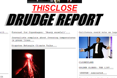
The "headlines" in the Drudge Report are examples of WEATHER. Remember, weather is CNN Headlines News, climate is the History Channel. Weather is "shorts or heavy jackets today?". Climate is the ratio of shorts to heavy jackets in your closet!
 Here is a global snapshot of CLIMATE. Data from January through late October shows that most of the planet experienced warmer than average temperatures for the majority of 2009. The exceptions: the northern USA and parts of northern Siberia. Otherwise just about the entire planet has experienced a warmer than average year, in fact NOAA data suggests that 2009 will wind up being the 5th warmest year since global records were started in 1850, another piece of an evolving climate puzzle. For more information click here for the State of the Climate.
 Warmest Years. The 10 warmest years on record have all been recorded since 1998 - worldwide. A coincidence? Maybe, but it's the Mother of All Coincidences.
Paul's Outlook for the Twin Cities
Today: More clouds than sun, not as bitter as yesterday. Winds: SE 5-10. High: 14
Tonight: Patchy clouds, not as "Nanook". Low: 6
Thursday: Mostly cloudy, few flurries possible, maybe a dusting. High: 25
Friday: Clouds, very light snow or flurries - dusting or coating possible. High: 24
Saturday: Intervals of sunshine, turning colder. High: 20
Sunday: Partly sunny, feels like January again. High: 18
Monday: A period of light snow possible - very light accumulation. High: 23
Tuesday: Peeks of sun, closer to "average" for late December. High: 26
- anonymous
Have you thawed out yet? You just survived/endured/enjoyed the coldest day of the winter so far (the mercury peaked at +4 F yesterday afternoon, well below the normal high of 26). At least the sun was out, which helped us (psychologically) weather the numbing burn of negative numbers. When the snow is squeaky underfoot, when you feel those annoying ice-crystals forming in your nostrils (I know, pretty gross) there's a VERY good chance you're wandering around in subzero cold. Look, the winter solstice is 5 days away - we shouldn't be too shocked or surprised to be tracking subzero air across the Upper Midwest. After the relatively balmy November we experienced I guess it was pretty much inevitable. Yesterday was typical for late January, when temperatures usually bottom out here in Minnesota. A little unusual for mid December, but hardly unprecedented.
Temperatures recover a bit today, although I'd hardly call teens a bargain. Winds have eased (no more windchill advisory). With the right clothing, and no exposed skin, there's no reason why kids can't be outside playing in the snow. As a rough rule of thumb when wind chills drop below -30 that's the threshold I use for cutting back on outdoor fun. Outtimers, veterans will laugh at that number (yes, it's pretty arbitrary) but the risk of frostbite and hypothermia at -30 F is about 3 times greater than at 0 F. Even kids (and adults) who are properly dressed in multiple layers can get into trouble very quickly when the wind chill dips below -30. Under those conditions frostbite can set in within 5-10 minutes. If you do suspect frostbite do NOT rub snow on the affected area. Bring the victim indoors, if possible, and very slowly and gradually thaw out the frostbitten area, in lukewarm water (or holding fingers under your armpits). Call a doctor for immediate treatment - severe cases can result in gangrene, which can sometimes lead to amputation.
The good news: no big, sloppy, headline-grabbing snowstorms or icy encounters are brewing between now and Christmas. Big Pacific storms whacking the west coast of the U.S. are weakening rapidly after crossing the Rockies - a few weak clipper-like systems may squeeze out a dusting or coating of light snow late Thursday into Friday, maybe a quick inch or 2" for far northern Minnesota. Another eastbound front may squeeze out a light accumulation of snow on Monday, but once again I just can't get excited about amounts.
After a slight temperature relapse over the weekend (teens - not as nasty-cold as yesterday) the mercury recovers into the 20s much of next week, much closer to average for mid/late December. The GFS model is hinting at a much colder slap of arctic air just before New Year's, but it's still premature to be talking about something 2 weeks away. No major travel headaches are anticipated between now and Christmas. Good news on the weather front!

The "headlines" in the Drudge Report are examples of WEATHER. Remember, weather is CNN Headlines News, climate is the History Channel. Weather is "shorts or heavy jackets today?". Climate is the ratio of shorts to heavy jackets in your closet!
 Here is a global snapshot of CLIMATE. Data from January through late October shows that most of the planet experienced warmer than average temperatures for the majority of 2009. The exceptions: the northern USA and parts of northern Siberia. Otherwise just about the entire planet has experienced a warmer than average year, in fact NOAA data suggests that 2009 will wind up being the 5th warmest year since global records were started in 1850, another piece of an evolving climate puzzle. For more information click here for the State of the Climate.
 Warmest Years. The 10 warmest years on record have all been recorded since 1998 - worldwide. A coincidence? Maybe, but it's the Mother of All Coincidences.
Paul's Outlook for the Twin Cities
Today: More clouds than sun, not as bitter as yesterday. Winds: SE 5-10. High: 14
Tonight: Patchy clouds, not as "Nanook". Low: 6
Thursday: Mostly cloudy, few flurries possible, maybe a dusting. High: 25
Friday: Clouds, very light snow or flurries - dusting or coating possible. High: 24
Saturday: Intervals of sunshine, turning colder. High: 20
Sunday: Partly sunny, feels like January again. High: 18
Monday: A period of light snow possible - very light accumulation. High: 23
Tuesday: Peeks of sun, closer to "average" for late December. High: 26
No comments:
Post a Comment