Here's the deal: I found a car, in this case on autotrader.com, a used car I wanted to buy. It could have been on cars.com or ebay.com, any site for that matter. The seller of the car claimed that she wanted to go through "MSN Autos", stating that MSN had a special escrow program. "They would ship me the vehicle to evaluate for 3 days, if I didn't like it I could ship it back, no questions asked, my money returned." All I had to do was make a wire transfer to MSN Autos in Seattle. The only problem? The fine print. It stated that the money would not go to MSN Autos directly, but into the Bank of America account of one "George Foster". First warning bell. At this point I was starting to seriously wonder what the heck was up, if this wasn't some elaborate scam.

Looks Semi-Official. Here is the e-mail I received from "MSN Autos", providing me with detailed information on where to send my wire transfer.

Third Strike. Here is when I knew I had (almost) been scammed. Check out the typo. That's a new spelling of "department" right? I can't imagine the REAL MSN/Microsoft making a similar mistake. Word to the wise: avoid making the mistake I almost made. There are a ton of these scams on the 'net right now. Buyer beware. If the deal seems to be good to be true, chances are it really is (too good to be true). Or in the words of my dear wife of 26 years, "Big Duh."
Sorry for the detour & diversion - but I'm really pretty peeved about almost getting scammed, and I wanted to err on the side of sharing this with you. Tell your friends, neighbors, anyone searching for a car on-line. The "MSN Auto Escrow" deal is a joke. One that may ultimately drain your bank account faster than you thought possible.
We enjoyed 55 F. on Monday, well above the average high of 43, but shy of last year's high of 61 F. on March 22. A slightly-cooler-front arrives today on gusty northwest winds (reaching 20 mph. at times). The high will still reach 50, give or take a degree or two, less sun, more clouds, more like the late March we know (and sort of love). A bubble of high pressure arrives Wednesday, meaning a welcome rerun of bright sun, highs in the low and mid 50s, another strong hint of spring fever in the air.
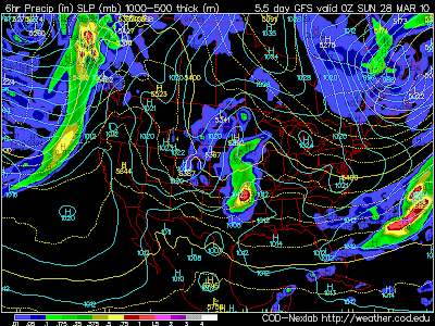
 Unsettled Saturday, slight chance of puddles (or flakes?) The GFS model valid Saturday evening at 6 pm shows another storm passing well south of Minnesota, the northern fringe of precipitation extending up into southern counties - the atmosphere marginally cold enough for a light rain-snow mix Saturday night. With highs topping 40 accumulating snow is theoretically possible (mainly south of the MN River) but unlikely. A damp start Sunday morning should give way to some PM sun.
Today's cool breeze will be the exception to the rule this week - highs from Wednesday through Saturday should rise well into the 50s, averaging a good 10 degrees above normal. Models are hinting at a cool-down early next week, maybe a few 40-degree highs, but hardly "arctic". A quick rebound is likely the first few days of April, another good chance of 60s, even a 70 showing up somewhere in southern Minnesota (along with a slight chance of showers, even a few thunder claps). In the meantime river levels should begin to recede later this week, the risk of brushfires and wildfires increasing in the coming weeks - until we green up in earnest. Where, exactly, is Earnest?


Strange But True. Where were these photos taken? Denver, Dallas, Grand Forks? Try northern Alabama. Early Monday enough slushy snow fell to make a respectable snow man. This, while we basked in the mid 50s. Talk about an upside-down weather map!
 A Slight Shift in Ice-Out Dates. According to the DNR ice comes off Lake Osakis about a week earlier than it did, on average, in 1867. Ice forms about a week later, on average, in November. Bottom line: Minnesota's ice season is 1-3 weeks shorter than it was a century ago.
Paul's Conservation MN Outlook for the Twin Cities and all of Minnesota
Today: More clouds than sun, windy and cooler. Winds: NW 10-20. High: 51
Tonight: Partial clearing, chilly. Low: 32
Wednesday: Sunshine returns, less wind. High: 55
Thursday: Partly sunny, still milder than average. High: 53
Friday: Mix of clouds and sunshine, milder. High: 57
Saturday: Clouds increase, slight chance of a shower. High: 58
Saturday night: Showers, possibly mixing with wet snow over far southern MN. Low: 37
Sunday: Damp start, then increasingly sunny, cooler. High: 45
Monday: Some sun, breezy, noticeably cooler. High: 43
No comments:
Post a Comment