The image on the left is traditional "reflectivity", the radar energy beam hitting rain drops and hail stones - but that purple-shaded area is the actual tornado itself - the radar beam being reflected back to the radar site, literally bouncing off the suspended debris being kicked up by the mile-wide "wedge" tornado. The image on the right shows radial velocity, this is the real power of Doppler radar. The bright purple area represents winds/raindrops moving AWAY from the radar site in Brandon, MS. The green/blue-shaded region is air moving TOWARD the radar site, at more than 80-100 mph. This is the most amazing Doppler Radar "couplet" I've ever seen.
Click here for more (amazing) details, Doppler images and photos from Saturday evening's super-outbreak. (Thanks to Dan Lillidahl, a Delta meteorologist working in Atlanta with deep Minnesota roots - for sending me this link).

* Winds increase today, topping 25 mph by mid afternoon, 70 a distinct possibility.
* Slight severe storm risk Thursday, conditions marginal, but a few isolated cells capable of large hail and damaging winds can't be ruled out.
* Wettest day of the week: Friday, NAM model printing out over 1" of rain, but odds are we'll see less. We'll see.
* Drier west/northwest breeze kicks in Saturday with some sun (lingering showers far northern Minnesota).
* Sunday: probably the drier, sunnier day of the weekend statewide.
 An April Like No Other. Check out the left column, the daytime highs for April - only one 3-day stretch with highs in the 50s. Almost every day has been above average in the temperature department, not one night colder than 32 F. in the Twin Cities. Amazing. Click here to see a climate recap for April (and the last 13 1/2 years, while you're at it).
Second warmest April on record for the Twin Cities? I have to double-check that nugget with Pete Boulay at the State Climatology Office, but there's no question we've had a very May-like April. 18 days above 60, 4 days above 70, 1 day in the 80s (April 1). Some April Fool's day, huh?
I have run out of superlatives - simply dazed and amazed by what is turning out to be the "best spring" I can ever recall (I've been here since '83 - with what I now consider to be a long, bad, 3 year mini-vacation in Chicago, live and learn). I realize that's a subjective statement, but I can't imagine a better spring. No accumulating snow since Feb. 23, NO SNOW IN MARCH! No terrifying tournament storms, no widespread severe storm outbreaks, nothing violent or controversial. Ice came off area lakes 2-3 weeks early (I have a friend who got his boat into the water on March 31, just to say he did it). Frost came out of the ground 10-20 days ahead of schedule. Yes, it's been a tough spring for allergy-sufferers, we've had a few days with stagnant air and unusual levels of pollution in the metro area, we experienced moderate flooding on area rivers, but the truth: it wasn't quite as bad as the flood forecasters were predicting. 23% of the state is in a "moderate drought" (see graphic below) and I'm more concerned about drought conditions across much of Minnesota lingering and expanding into the summer months. But all things considered - you couldn't ask for a more cooperate spell of weather stretching back to mid February.
 A Thundery Fly in the Weather Ointment? SPC (Storm Prediction Center) is forecasting a slight risk of a few isolated severe storm for portions of central and southern MN Thursday as a cooler front advances eastward from the Dakotas. The best chance of hail/strong winds: around the dinner hour, give or take 3 hours. Click here for more information from SPC.
Perspective. We're so quick to gripe about the elements floating above our heads (at least I am). Time to give thanks for what can only be described as atmospheric blessings - the kind of spring the Minnesota Chamber of Commerce dreams about. It's worth repeating: a 6 MONTH BOATING SEASON....in Minnesota! Missouri's weather has shifted north about 500 miles and set up shop directly over the Gopher State, a pleasant turn of events. Meanwhile much of America has been tormented: unusually heavy snow from Denver to Dallas to the suburbs of Atlanta lingering into March, killer tornadoes in Mississippi, unusually wet, cool, foul weather for New England, reports of 120 mph winds in the mountains of California late Tuesday. While we sit up here on the (alleged) tundra, and count up the sunny, 60-degree days, marveling at our good meteorological fortune.
 Friday Puddles? Models are hinting at a wave of low pressure rippling northward along the next weather-maker, a cool front pushing in from the west. If (and it's still a big if) this actually verifies, we could see some .50 to 1.0" rainfall amounts. If the front just sails through (more likely) amounts will probably be less, more like .25 to .50".
 Dueling Models. The latest NAM model is hinting at over 1" of rain, but it's something of an outlier - the other models are suggesting closer to .30 to .60" of rain, which I think is more likely from Friday's cool frontal passage.
Today will be sunny, windier (gusts to 25 mph by mid afternoon), a southeasterly breeze that may lure the mercury close to 70 by late afternoon. Clouds will increase, forerunners of a cool frontal system capable of igniting a few strong/severe storms late Thursday. Conditions are marginal, but I wouldn't be shocked to see some watches and warnings issued later in the day tomorrow. One model (NAM - usually the most reliable) prints out over 1" of rain Thursday night into Friday as a wave of low pressure ripples right up that advancing wedge of cooler, drier air. My hunch is that we'll wind up with something closer to .25 to .50" of rain. Skies begin to clear Saturday, although scattered "backlash" showers may linger over far northern Minnesota much of Saturday. In general, the farther north you drive Saturday the cloudier the weather, most of the showers staying north of Bemidji and Grand Rapids. A weak bubble of high pressure pushing into the state from Canada should translate into more sun on Sunday, highs in the 60s - a nice way to ease into May. No cold fronts, no snow or frost in sight - nothing that will lead area newscasts (except for that slight severe risk late Thursday).
Not a bad spring to be a meteorologist in Minnesota. I'm soaking it up while I can.
 Unsettled Saturday. Although some sun is expected during the morning/midday hours Saturday, a lingering pool of cold air aloft, coupled with moisture wrapping all the way around an area of low pressure in the Great Lakes (what we fondly refer to as "backlash") may spark a few pop-up showers and sprinkles over the northern third of Minnesota, especially mid afternoon into Saturday evening. if you're heading up to the cabin, north of the Whitefish Chain especially - have a Plan B (indoors) after about 1 or 2 pm. Not an all-day rain up north, but a few hours of showers can't be ruled out.
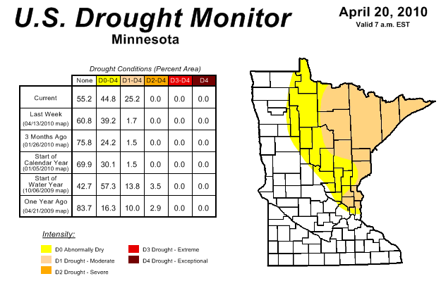 Expanding Drought. The latest Drought Monitor shows that 25.2% of Minnesota is experiencing "moderate drought." That's up from just 1.7% of the state that was in a moderate drought on April 13. We need a long, soaking rain - although some towns may pick up a half inch or more of additional rain late Thursday into Saturday morning, it probably won't be enough to pull the northeastern third of the state out of a nagging drought. Click here to see the latest Drought Monitor. (Keep clicking on Minnesota to zoom in and get the stats for our state).
 Oil Slick from Space. You're heard about the major oil spill in the Gulf of Mexico? It's so big it actually shows up on NASA's low-orbiting satellites. For more on the slick, and its implications, click here for an update from the New York Times. The oil spill is only 20 miles off the coast of Louisiana, and the implications for aquatic life in the Gulf are grim.
 Down to 25. Better load the kids into the SUV and hurry out to Glacier National Park. A recent report shows 25 glaciers left, down from 150 in the mid 1800s. The National Resources Defense Counsel (NRDC) has issued a report on the slow-motion transformation taking place in Montana - as well as the implications, for plants/animals nearby, as well as Montana's economy.
Paul's Conservation MN Outlook for the Twin Cities and all of Minnesota
Today: Hazy sun, becoming windy and warm. Winds: SE 15-30. High: near 70
Wednesday night: Partly cloudy and mild. Low: 54
Thursday: Peeks of sun, more humid, a growing chance of T-storms (a tiny percentage could become severe). High: 74
Friday: Periods of rain expected - wettest day in sight. High: 66
Saturday: Partly sunny, drying out (few PM showers far northern MN). High: 65
Sunday: More sun, pleasant. High: 67
Monday: Sun much of the day (a few nighttime showers possible). High: 68
Tuesday: Mix of clouds and sun. High: 65
No comments:
Post a Comment