* Stormier pattern next week? Models hinting at scattered showers/T-storms from Monday PM into Thursday of next week.
* Rain gear for the Twins Opener. Most of the rain will probably hold off until Monday night, but we can't rule out a stray storm arriving by the 5th inning of game #1 vs. Boston.
* No cold fronts in sight, snow season is, in all probability, over. Earliest end to the accumulating snow season in Minnesota since modern-day records began in the late 1800s.

The weather news is good, almost too-good. A fizzling cool front may spark an early shower, but a drying westerly wind behind the front will coax plenty of sun out of our Saturday sky, and Sunday looks even nicer (more sun, less wind, highs a few degrees warmer). A southerly fetch of moisture from the Gulf of Mexico will increase the opportunity (not threat) of showers and T-storms early next week, as early as Monday.
Too early to give an accurate forecast about the Twins Opener (yes, our weather will once again be under a national microscope - at least it won't snow!) The chance of showers and T-storms will increase as the day goes on, we just can't rule out a shower or T-storm later in the game. Believe me - we'll keep an eye on Monday's forecast. A stalled boundary draped from east to west from Huron to St. Cloud to Eau Claire will act as a shower-magnet next week, resulting in several waves of showers and T-storms from Monday through Thursday, a few could (in theory) be strong to severe. I won't be surprised to see some watches and warnings issued close to home by Tuesday or Wednesday of next week. We welcome the rain, the beachball-size hail we can all live without. BTW, the criteria for a "severe thunderstorm" has changed this year. The NWS issued previous severe storm warnings based on 3/4" hail. Now they've raised the bar to 1" in diameter, roughly quarter-size. The reason? Too many warnings, a sense that they were "crying wolf" too often, and frankly hail usually has to reach 1" in diameter before it causes real damage to rooftops, windows and car surfaces, especially if it's whipped along by 57 mph+ winds, another criteria for severe designation. Hopefully this will cut down on the sheer volume of severe storm warnings this year, highlighting the storms that are truly dangerous.
 Midweek Severe Outbreak? A stubborn frontal boundary nearby, a scuffle between warm, moist air from the Gulf of Mexico and cooler, drier Canadian air, will set up over Minnesota from Monday through Thursday of next week. The best chance of some .50"+ rains will come over far western Minnesota. Dynamics aloft will be weak to moderate - can't rule out an isolated severe storm the first half of next week.
We dry out by Friday of next week, more 60s the following weekend under a mostly-blue sky. I still don't see anything that remotely resembles a "cold front". If you missed out on the frost this morning, chances are you won't be scraping icy designs in your car windshield for at least another 10-15 days. We've skipped another month, gone right to May. I'm not hearing too many complaints, come to think of it. Everyone is pretty thrilled (and dazed) by our REAL SPRING. Welcome to what will probably go down in the record books as "Minnesota's Easiest Spring." Amazing.
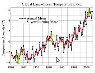 Global Temperature Trends. Is global warming an (inconvenient) scientific fact, or a myth? Click here for an interesting look at some of the arguments brought up by climate-change skeptics. Anyone can cherry-pick a specific scientific finding to prove a point. The key (in my opinion) is to step back, look at as many pieces of the climate puzzle as possible, to reach a conclusion, one that may change over time as new data arrives. The scientific method is messy, at times sloppy, but in time the (real) truth will come out. The question is: by that time will it be too late to do anything about it?
Paul's Conservation MN Outlook for the Twin Cities and all of Minnesota
Today: Plenty of sun, breezy, quite pleasant. Winds: W 10-20. High: 63
Saturday night: Partly cloudy and cool. Low; 44
Sunday: Even nicer, sun much of the day, less wind. High: 65
Monday: Clouds increase, good chance of showers/T-storms by Monday evening/night. High: 64
Tuesday: Some sun, more humid, a few scattered T-storms (some strong?) High: 71
Wednesday: Unsettled, a few heavy showers/storms nearby. High: near 70
Thursday: Lingering showers (mainly southern MN). Thunder possible. High: 66
Friday: Drying out, more sunshine. High: 63
No comments:
Post a Comment