
 Aurora Watch. A storm on the surface of the sun sparked a "solar wind" yesterday, hitting the Earth's magnetic field, resulting in spectacular "Northern Lights" visible in Finland. There is a small chance that we may see a similar celestial event in the coming nights. Keep your eyes open. The story at spaceweather.com is here.
* It's a glorious spring, but allergy-sufferers are not happy. The combination of very dry conditions, gusty winds and blooming plants and flowers have caused pollen levels to spike. Could what's happening in the Kansas City area spread north to MSP? Count on it.
* April: 11.1 F warmer than average for the first half of the month.
 Thursday Almanac. Wednesday night's cool frontal passage triggered .56" rain at MSP, .61" at Eden Prairie, .40" at St. Paul and .27" at Crystal (north metro) A total of .35" fell at Redwood Falls, but no rain was reported in St. Cloud. A fickle front indeed. Thursday highs ranged from 75 in Rochester (!) to 73 at Duluth, 71 at MSP and 67 at St. Cloud.
Welcome to the coolest day in sight, in spite of bright sunshine afternoon temperatures will hold in the 50s, a stiff north wind gusting past 25 mph. at times. Winds ease up a bit tonight, setting the stage for patchy frost, especially north of a line from St. Cloud to Princeton and Taylor's Falls. A bubble of Canadian high pressure passes directly over Minnesota this upcoming weekend, promising blue sky, less wind, low humidity levels, virtually no chance of rain until next Wednesday, when some models are hinting at a few spotty rain showers as a weak front arrives. In fact it appears that the atmosphere may become temporarily locked in a "holding pattern", high pressure stalling out over the Great Lakes, forcing storms to take a detour well south/west of Minnesota through most of next week. Models are hinting at some rain next weekend, the weekend of April 24-25, but it's too early to know for sure (yet).
Sunday may well wind up being the nicest day of spring, a sun-scrubbed sky, light winds, little humidity, few bugs - a day that would make the Chamber of Commerce proud. Only allergy sufferers may be crying the blues. Until we get a good soaking rain the combination of gusty winds and flowering vegetation will cause pollen to spike off the charts. It will take a soaking to clean the air, bring some of these natural pollutants down to the ground. That won't happen anytime soon, not for another 7-8 days at the earliest.
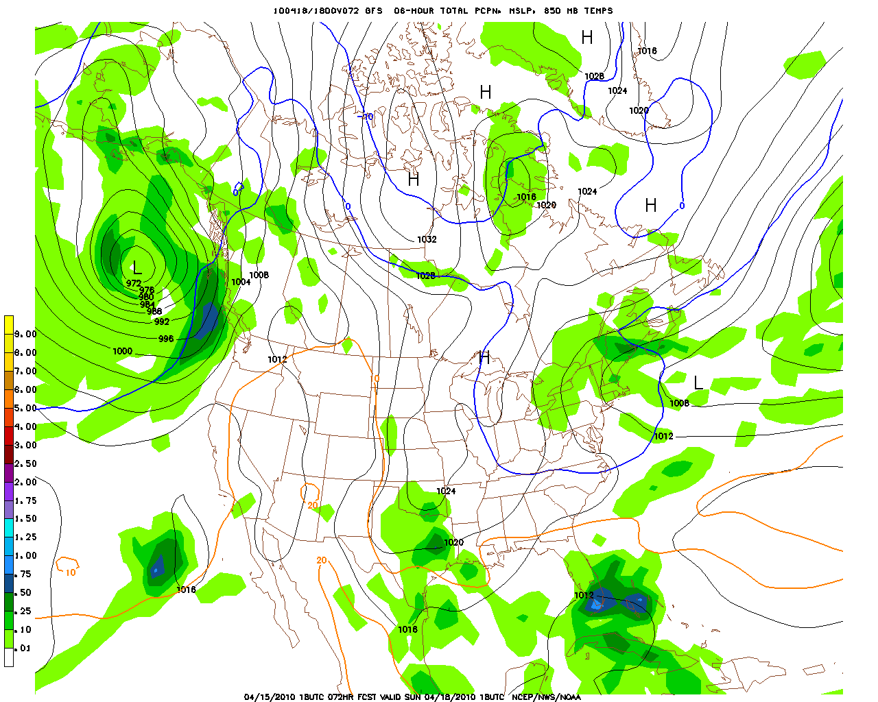 Holding Pattern. The models are predicting that weather systems will temporarily stall, a fair weather bubble of high pressure parked over the Great Lakes, keeping us partly to mostly sunny through most of next week. The fire risk is already high, and will undoubtedly get much higher next week. Farmers need a good soaking rain to replenish soil moisture - I don't see that scenario shaping up for at least a week.
 Drought Potential. Check out the area of severe drought over much of northern Wisconsin, the northeastern half of Minnesota is still too dry. My hunch is that moderate drought conditions may return just north/east of the Twin Cities and St. Cloud by the end of next week. Hope I'm wrong on that call. To see the DNR Drought Monitor for yourself click here.
 Ash Cloud. The impossible-to-pronounce Icelandic volcano recently erupted, sending a massive plume of ash, smoke and dust into the atmosphere, swept hundreds of miles downwind by strong, jet stream winds blowing between 25,000 and 30,000 feet. The Ejyafjallajokull volcano has done what no terrorist attack could ever do - shut down all air traffic into and out of the U.K. Thousands of flights have been affected across Europe and the U.S. (Iceland is almost directly in the path of the "Great Northern" route that transatlantic flights take). Ash and jet engines don't mix, even a small amount of ash entering a jet turbine can cause the engine to seize up and fail, with potentially disastrous implications for all on board. For an eye-opening article in National Geographic click here, another great story here.
 NASA "Terra" High-Res Satellite. It's hard to miss the plume of ash being swept hundreds of miles downwind, toward Sweden, Finland, Norway and the U.K. According to Boeing, at least 90 jet-powered aircraft have encountered volcanic plumes of ash in just the last 30 years, with a few very close calls. In 1989 all 4 engines on board a Boeing 747 failed after the plane flew through a volcanic ash plume. Luckily the pilots were able to restart all the engines and the plane made an emergency landing. More on the unpleasant side effects of ash in this story.
There are potential climate implications: especially large volcanic eruptions can eject ash into the stratosphere, 12-20 miles above the ground, with a subsequent cooling effect worldwide, and some amazing sunsets. Early indications are the Icelandic eruption, however spectacular, did not pump ash into the stratosphere - the odds of this particular volcano impacting US or global weather are unclear, but right now it does not look like this eruption rivaled the El Chicon eruption in Mexico, or even the Mt. St. Helen's blast which shook Washington state on May 18, 1980.

 One Very Green Ballpark. An estimated 20% of Target Field was constructed with recycled materials - click here for a great overview of the green aspects of our brand new stadium from Marty Broan at Conservation Minnesota. We can be proud of the Twins on many levels, including concern for the environment.
Paul's Conservation MN Outlook for the Twin Cities and all of Minnesota
Today: Sunny, windy and comfortably cool. Winds: N 15-25+ high: 58 (coolest day in sight).
Friday night: Clear, some patchy frost far northern suburbs. Low: 38
Saturday: Bright sun, less wind. Winds: N 10-15. High: 67
Sunday: Perfect, blue sky, lukewarm. High: 71
Monday: Partly sunny, still dry. High: 66
Tuesday: A mix of clouds and sun, high pressure holds on. High: 65
Wednesday: Sunny, still tranquil, starting to dry out again. High: 67
Thursday: Clouds increase, still dry. High: 66
No comments:
Post a Comment