Best Cabin/Beach Day: Saturday (low 80s southern lakes, mid to upper 70s northern lakes). Winds: S/SE 10-20.
Best Day To See a Movie: Sunday. Expect highs in the 70s, a few hours of showers, possible thunder.
Memorial Day Weather: coolest day of the bunch: comfortable, sweatshirt weather in the morning, but lukewarm by afternoon as sun gives way to increasing clouds. A few showers/sprinkles possible far northern MN by midday/afternoon.
 Tracking Heavy Weather. Last night around 9 pm NWS Doppler from MPX showed heavy showers and T-storms over the eastern metro of the Twin Cities, 1/2 to 3/4" hail showing up in western Wisconsin. Remember, this year the criteria for a "severe" thunderstorm has changed, from 3/4" to 1" diameter hail, roughly quarter size.
 Fickle Rainfall Patterns. Doppler radar from MPX (based at the NWS in Chanhassen) shows the bizarre rainfall patterns around the metro area, over 3" east of Hastings and Cottage Grove, little or no rain over the far western suburbs of Minneapolis. In spite of Doppler and supercomputers there is still no way to effectively predict these kinds of rainfall variations more than 6-8 hours in advance.
 I'm having a strange spring - stuff that I never could have imagined (or predicted) over 2 years ago when 'CCO and I parted ways. Sometimes you're put into a situation you didn't ask for, certainly didn't expect, you sit there and wonder, "why me, why now?" Sometimes you get an answer right away, but more often it takes months, even years, for you to understand why you were put on this new path. It's happened to all of us. NOW I can look back and say, "aha, that's why it happened the way it did - I had to go through a trial by fire to get to the other side and have new opportunities fall into my lap, things I couldn't even imagine 26 months ago, when I was in a serious funk. God has a plan - these mid-career gyrations can be a real body-blow to the ego, a blunt reminder that we're not in control nearly as much as we think we're in control. Man plans, God laughs. Right.
In the last few weeks I've made friends with new meteorologists, extraordinary people who were also let go from local TV stations, going through their own mid-life crises - wondering what comes next. We launched a national weather channel on Dish, stayed up for 4 entire days (!) before bigger forces intervened. A worthy experiment - one that is far from complete. Not sure what comes next, but when you surround yourself with amazing people, miraculous things can happen. In today's breakneck, fast-paced, information-saturated, Internet-powered economy the most important asset your company has is not hardware, software, bandwidth or intellectual capital - it's your people. A+ people have a knack for attracting other A+ people. I've been blessed with some of the smartest, most tenacious and creative people in Minnesota, and I take nothing for granted. The only way to survive today is to be mean and lean, adapt instantly, turn on a dime, take advantage of new opportunities that weren't on your radar screen a week ago.
 Enhanced IR Satellite. The image taken Tuesday night at 10 pm showed the fickle front draped across the state, individual showers drifting from southeast to northwest (!)
 Satellite Close-Up. The coldest, thickest clouds (tops of thunderstorms) show up as bright green/yellow on this enhancement curve. We rely on IR satellite images at night (no sunlight to reflect off of clouds). These are lower-resolution images, but still very helpful in trying to track weather 24/7.
I'm rambling....sorry. Ignoring the weather. A dangerous thing to do here in the great (unstable) state of Minnesota. Yesterday was a strange day, warm sun giving way to T-storms (approaching from the southeast during the evening hours). 95% of the time weather systems approach from the south, southwest, west or northwest, but moving in from the SOUTHEAST? Very odd. It happens when systems stall; sometimes weather patterns "retrograde", moving from east to west, or southeast to northwest. Odd, but hardly unprecedented.
If you live in the east metro you won't have to water anytime soon - far more rain eastern suburbs of St. Paul than the western suburbs of Minneapolis. This is why meteorologists have gray (thinning) hair - if they have any hair left they haven't pulled out (by the fistful). Summer showers and T-storms are fickle and extremely variable - some towns get drenched, while 10 miles down the road the sun is out and locals are wondering what all the fuss is about. Such was the case late Tuesday.
Winds swing around to the north/northeast today, pushing showers and T-storms south of Minnesota. Count on blue sky, gentle breezes, highs in the upper 70s to low 80s. By this time tomorrow there will be HALF as much water vapor in the air as there was Monday, when the mercury soared to a steamy 95 (with a dew point of 69). For every 20 degree drop in dew point the amount of water in the air drops by roughly half. There's some memorable weather trivia for your next party. Use it if you want to be isolated, ostracized, pointed at, the subject of whispers and muted laughter. Better not to bring up the dew point at all, come to think of it.
The sun stays out from today through most of Saturday, temperatures running 5 to 10 degrees above average with low humidity, little chance of any red pulsating blobs showing up on Doppler radar until sometime Sunday.
 Saturday, noon. Models keep showers and T-storms just north/west of Minnesota, sunshine much of the day, highs ranging from mid 70s (north) to low 80s (south). Expect a wind blowing from the south/southeast at 10-20. Saturday should be the best day for the lake/beach/pool.
 Sunday, 6 pm. The best chance of a few showers/T-storms will probably come later in the day Sunday and Sunday evening, not an all-day rain, but a few hours of showers and possible thunder. Expect highs near 70 (north) to mid 70s (south).
 Monday, noon. A cooler front pushes across the state Memorial Day, whipping up a cool, northwest wind (10-20 mph) with ample sun central and southern MN, but a fair amount of cloud cover over the northern third of the lake, where highs may hold in the mid 60s. Expect highs in the low 70s southern lakes by mid afternoon - probably the coolest day of the holiday. Pack a sweatshirt/jacket, especially if you're heading up north.
 Volcano Update. The Icelandic volcano is still puffing away - some days emitting significant smoke and ash, other days mysteriously quiet. For an amazing time lapse click here.
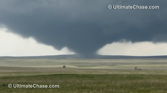 Wedge. Another amazing clip of video shot near Faith, South Dakota, a tornado so big, so "fat", that it doesn't even resemble a classic tornado funnel. Credit: ultimatechase.com
 Waterspout. A tornado vortex forming over water is called a waterspout. This image was taken off the coast of Sydney, Australia.
 Kamikaze Comet. Check out this time lapse of a comet hitting the sun, tracked by NASA satellites over a 2-day period. Amazing.
 Uff Da Palace. Just when you think you've seen everything, along comes a fascinating story from Conservation Minnesota. You can see it first-hand at the MN Landscape Arboretum near Chaska. Very cool.
Paul's Conservation MN Outlook for the Twin Cities and all of Minnesota
Today: Plenty of sun, breezy and less humid. Winds: North/Northeast 10-20. High: 79
Wednesday night: Mostly clear, comfortably cool. Low: 58
Thursday: Bright sun - beautiful. High: near 80
Friday: Blue sky, close to perfect. High: 82
Saturday: Warmest day of the holiday weekend. Fading sun, breezy and warm. High: 83
Sunday: Clouds increase, a few PM showers, possible thunder. High: 76
Memorial Day: Partly sunny, breezy and cooler. High: 72 (60s north - a few PM showers far north).
Tuesday: Clouds increase, chance of a shower late. High: 73
Hey Paul we miss you from KARE 11 back in the day! You were always accurate & had an explanation for the weather.
ReplyDelete