First Tornado of the Year. We have a confirmed tornado touchdown, 3 miles north of Leaf Valley, in Douglas County, around 3:45 pm. No reports of damage or injuries - yet. The storm was preceded by 2-3" diameter hail.
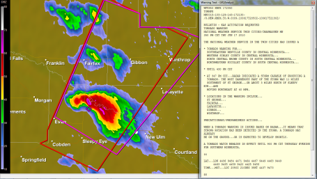
Tornado Warning: Gibbon, Winthrop and Fairfax under a tornado warning.
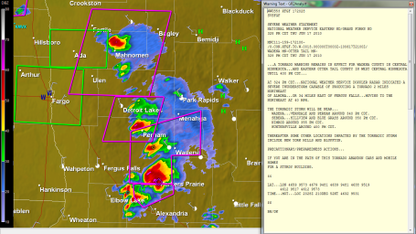
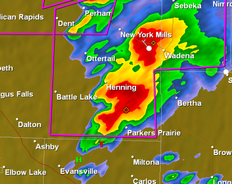
More Tornado Warnings: posted from Parker's Prairie and Wadena to Detroit Lakes area and Mahnomen, all popping along a vigorous warm frontal boundary.
New Tornado Watch until 9 pm, includes St. Cloud and Twin Cities. Strong storms forming over western MN - still turn severe in the coming hours, possibly reaching the metro area between 6-8 pm, give or take.
Significant Tornado Risk. Latest parameters from SPC show the greatest risk over far west central MN, near Wheaton and Breckenridge - I expect a line of severe storms to bubble up over far western MN by 2 or 3 pm at the latest.
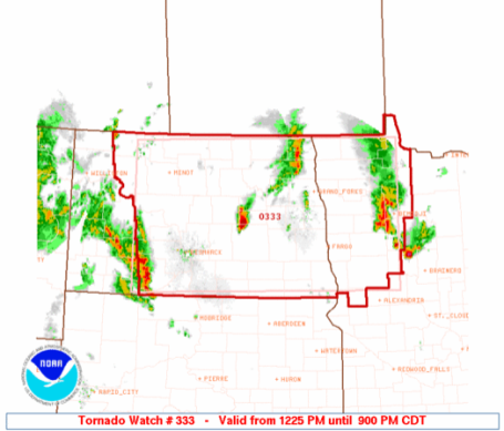
Tornado Watch until 9 pm. The watch means "watch out", stay alert, stay tuned to local media for updates. The watch area includes Detroit Lakes, Bemidji and Thief River Falls, as well as the Fargo-Moorhead area. More from SPC here.
Moderate Threat of Tornadoes. SPC has most of central and southern MN in a moderate risk, although the greatest threat of tornadoes appears to be just south/west of the MN River. A tornado could touch down anywhere from Brainerd to the Iowa border later today - stay alert, go about your normal activities, but keep an eye on the sky, stay tuned to (local) media, and check back often for updates. My (pure) gut feel on which area might be most at risk: Tracy to Breckenridge to Windom. Before the day is through I fear that one or more communities in MN may experience a large, violent, long-lasting tornado. Hope I'm wrong, but the ingredients seem to be converging for a fairly significant tornado threat, especially far southwestern MN.
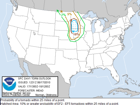
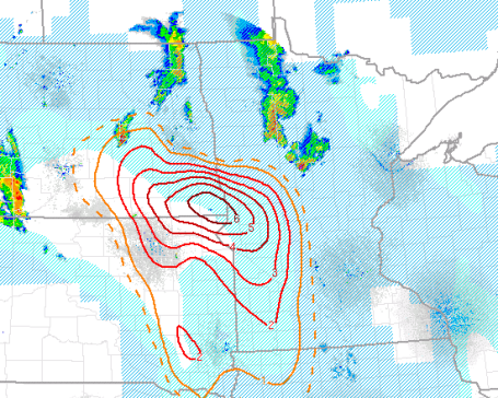
Tornado Risk. This SPC graphic shows the risk of a tornado within 25 miles of any given point - a 10% risk of an EF2-EF5 tornado for much of central, west central and southwestern MN. This is about as high as these parameters get - thus the very real fear of a significant tornado later today, best chance south/west of St. Cloud and the Twin Cities. Stay tuned...
No comments:
Post a Comment