Thursday: Plenty of sunshine, still pleasant with less wind. High: 83
Thursday night: Clouds increase, a good chance of T-storms late at night. Low: 65
Friday: Storms early, then partly sunny - drying out during the day. High: 81
Saturday: Partly cloudy - reasonable humidity, light winds (probably the nicer day). High: 84
Sunday: Hazy sun, a little more humidity creeping back into town. T-storms far western MN late in the day (but probably dry from the northern lakes into the metro area). High: 86
Monday: Less sun, good chance of a few T-storms. High: 85
Tuesday: Unsettled, another T-storm or two. High: 84
Wednesday: Drier, more comfortable. High: Near 83
Canadian Fires Make For a Nice Sunset
Here's a picture that I took Wednesday night near sunset. The brilliant reddish/orange glow was from the smoke and haze drifting southward from northern Saskatchewan Canada.

This map comes from Canadian Natural Resources website - The red dots indicate where the actual fires are burning. The gray color indicates where smoke can be found.

This is the National Weather Services interpretation of smoke/haze drifting into the Lower 48:

Smoke seen via visible satellite (nearly 23,000 miles above the Earth's surface) drifting over Ontario Canada, on its way into Minnesota:

Lightning Fatalities Continue to Grow
The number of lightning fatalities for the year 2010 currently stands at 19. 2 others were recently shocked by lightning near Denver Colorado Wednesday afternoon. Remember, that if you can hear thunder, you are within striking distance, get to a safe shelter immediately. Read more lightning safety tips here:
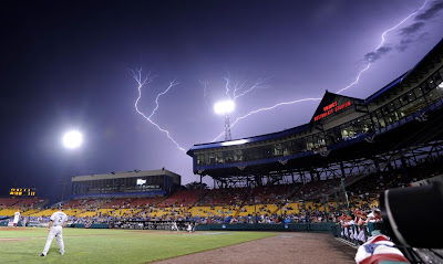
 Lightning bolts light the sky above Rosenblatt Stadium where South Carolina plays Oklahoma in an NCAA College World Series baseball game in Omaha, Nebraska on Sunday, June 20, 2010. (AP Photo/Eric Francis)
See more incredible weather photos here - you won't be disappointed, I promise!
 Lightning flashes across the sky over Maquoketa, Iowa Friday June 18, 2010.
(AP Photo/Kevin E. Schmidt, Quad-City Times)
Interesting Martian Dust Devil
After an impressive 6 and half years on Mars, NASA's Mars Exploration Rover Opportunity found a martian weather phenomenon - A Dust Devil! Read more here:

NOAA: Past Decade Warmest on Record According to Scientists in 48 Countries
Here's an interesting read from NOAA - "The 2009 State of the Climate report released today draws on data for 10 key climate indicators that all point to the same finding: the scientific evidence that our world is warming is unmistakable."

Thursday Night Thunder
Our next best chance of thunder rumbles in late Thursday night into early Friday. There could be pockets of heavier rain (up to 1 inch) in heavier thunderstorms around parts of central and southern Minnesota through early Friday. Looking ahead into the weekend... Most of the weekend appears to be dry and mild. Late day showers or storms can't be ruled out on Sunday, but most of the day will be dry. Below is the 6 hour accumulated precipitation total from 1am to 7am Friday.

Have a good Thursday - Todd Nelson
No comments:
Post a Comment