Friday: Sun much of the day - isolated instability shower or thundershower possible late Friday and Friday night. High: 86
Tonight: Partly cloudy and comfy. Low: 65
Saturday: Summery and a little unsettled. An isolated afternoon/evening shower or thunderstorm possible west. Winds: SSW 10-20. High: 85
Sunday: Scattered showers and storms. Slightly cooler, but muggy. Winds: SW 10-15. High: 83
Monday: Showers linger early (especially southern MN). Some clearing central and north. High: near 81
Tuesday: Partly cloudy, more showers/storms possible late west. High: 82
Wednesday: Warm and muggy. Thunder potential continues. High: 85
Thursday: Unsettled, slight chance of a passing PM thundershower. High: 83
Recent Wisconsin Tornado Caught on Tape
It has been a slow start for tornadoes nationwide this month, but one struck closer to home on Wednesday. Take a look at the tornado video below from Cambria, WI:
 Here's the link:
The National Weather Service has a nice write up about the tornado here:
Heat Continues in the East
The past few days have been extremely hot for those out east. The map below shows 267 record high temperature reports nationwide with the most notable reading coming in from Baltimore International Airport BWI @ 105° – this ties the All-Time Record High ever recorded there also set on August 20th, 1983

For all you sports junkies out there, the heat is definitely on in Miami with the recent report of Lebron James joining Wade and Bosh for the upcoming NBA season.

Solar Activity
The latest solar activity is quite interesting. NASA Satellites have been watching several intense eruptions (Coronal Mass Ejection) on the western limb of the sun, which is likely to turn face to the Earth by the weekend. Any eruption pointed at us here on Earth could bring bouts of Northern/Southern Lights.
 Watch the Video Here:
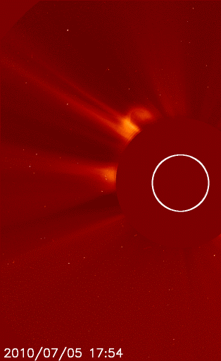
Closer to Home:
Scattered showers and storms may be possible late this weekend as a more significant storm system nears. Take a look at the weather map for Sunday:

More organized showers and thundershowers will be possible Sunday, but up until then, we should be able to enjoy mostly dry skies with temperatures hovering near or slightly above average - Todd Nelson
No comments:
Post a Comment