* Friday will feel more like early October, but conditions slowly improve over the weekend.
* Saturday: coolest day, highs hold in the 60s.
* Slight chance of frost (way) up north Sunday morning.
* Best day of the holiday weekend: Sunday (plenty of sun, lukewarm with less wind statewide).
* Labor Day: mildest day, but a growing chance of a shower or T-shower.
Ominous Sight. This late afternoon (visible) satellite image from NOAA showed (category 4) Hurricane Earl pushing northwest toward the Outer Banks of North Carolina. 300 miles wide, Earl is as large as Katrina was 5 years ago. More on the big weather story below.

 Evidence of Intensification. The Wednesday evening (enhanced) infrared satellite image shows a nearly perfectly symmetry "eye" for Earl. A day before the storm had looked a bit ragged, wind shear aloft slightly shredding the storm, creating a lop-sided appearance to the eye and surrounding eye-wall (where the strongest winds are blowing). Wednesday the storm passed over unusually warm water and upper-level winds lessened, creating ideal conditions for further strengthening. Sure enough Earl went from a category 3 to a category 4 storm. Some weakening is likely today, but Earl may still brush the Outer Banks as a major category 3 storm, winds late tonight (when the eye passes closest to N. Carolina) probably in the 115-130 range. Of even greater concern: sustained winds and unusually low air pressure near the eye creating a "bulge" of water, shoved ashore ahead of the "eye" - the storm surge, with tides rising as much as 5-15 feet above normal, potentially inundating large portions of the Outer Banks. Image courtesy of WeatherTap.
 Earl From Space. The ISS, the International Space Station, captured Hurricane Earl as it passed 218 miles overhead. The Russian Soyuz spacecraft is visible in the foreground - the tightly packed "eye" of Earl visible left of center. Around that (relatively calm) eye - sustained winds raging at 135 mph, gusts to 160 mph.
 Consistent Models. 15 different models - all pretty much in alignment about the future track of Hurricane Earl. A curve to the northeast is inevitable (the result of jet stream steering winds nudging the storm, and in the nick of time). That said, the Outer Banks of North Carolina can expect hurricane-force wind gusts and a 6-8'+ storm surge tonight and early Friday. Click here for the latest track (hit reload on your browser to see the very latest guidance).
 First Frost? Some of the computer models are hinting at a light frost over far northern Minnesota Sunday morning, from International Falls to Embarrass and Tower. If skies are clear (likely) and winds subside or go calm (very possible) and enough dry air surges south out of Canada (almost guaranteed) then temperatures could fall to, or just below, 32 F. by 6 am Sunday morning. A word to the wise: pack a sweatshirt or jacket if you're heading north this weekend.
 Best Day of the Labor Day Weekend? Saturday will be unusually cool (but sunny most of the day). Labor Day will be unsettled, milder but mostly cloudy with a passing shower or two likely on Monday. Sunday may just wind up being the best day to sneak out to the lake or pool - highs in the low 70s (north) to mid 70s (south) with relatively light winds, blowing from the east at 7-12 mph. Factor in low humidity and plenty of sun (fading beneath a smear of high, thin cirrus clouds) and you have all the makings for a memorable Sunday. To see the weekend weather details for yourself, click here - data courtesy of NOAA.
 Wondrous Wednesday. Dew points near 50, blue sky (at least over the eastern 2/3rds of Minnesota, a light breeze - not a bad way to spend a Wednesday). Highs ranged from 62 at Grand Marais to 76 in St. Cloud, 77 in the Twin Cities.
_________________________________________________
Paul's Conservation MN Outlook for the Twin Cities and all of Minnesota
Today: Showers and thunderstorms likely - locally heavy rain. Winds: SW/W 10-20. High: 68
Thursday night: Rain tapers, turning breezy and cooler. Low: 57
Friday: Mostly cloudy, windy and cool - a few sprinkles possible. It may look & feel more like late September/early October. Winds: NW 10-20+ High: 65
Saturday: Coolest day of the holiday weekend. Plenty of sun, still breezy - very comfortable humidity levels. Winds: NW 10-15. High: 66
Saturday night: Clear and chilly - jacket weather. Low: 52 (40s across much of Minnesota)
Sunday: Partly sunny, less wind - possibly the nicest day overall. Winds: E 7-12. High: 73
Labor Day: Mostly cloudy, milder with a passing shower, slight chance of late-day thunder. Winds: SE 10-20. High: 79
Tuesday: Early shower, then clearing and windy. High: 82 (falling during the afternoon).
Wednesday: Some sun north, showers and storms over southern MN and Iowa. High: 78
_________________________________________________
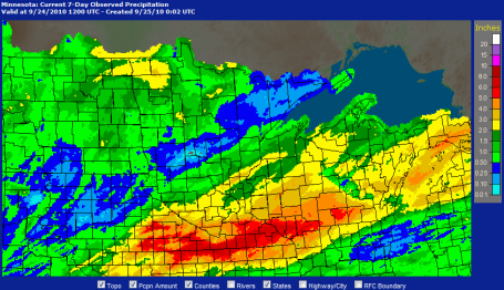
Another day - another spirited round of showers (and thundery-showers). We picked up our one-day ration of cool, comfortable sunlight Wednesday (70s have never felt better combined with dew points dropping into the upper 40s) but now it's back to umbrellas, jumbo puddles and too many colors showing up on the Doppler radar. The odds of anything severe flaring up are slim, but not zero (a very slight risk over southeastern MN, south and east of the Twin Cities). Moisture is limited, wind shear marginal, the best chance of enough instability to whip up a few strong/severe storms over far southern MN, near the Iowa border. Hold off on watering the yard - models are printing out a half to three quarter's of an inch of rain today. Lug along something waterproof, 3-6 hours of rain may fall today, heavy at times, with a few embedded T-storms, best chance over the southern third of Minnesota.
Rain tapers this evening, winds swing around to the northwest Friday, moisture wrapping all the way around this next storm, keeping us mostly gray, gusty and cool most of Friday. Highs hold in the 60s, even some 50-degree HIGHS over far northern Minnesota - a definite taste of what's to come. Throw in a few sprinkles and light showers (especially up north) and you have all the ingredients for a thoroughly forgettable Friday. Skies clear late Friday night and the sun should be out much of Saturday, without question the coolest day of the holiday weekend. Winds will ease up a bit, but it will be BRISK out there on your favorite lake as we wake up to 40s, and only peak in the low to mid 60s over central and northern MN - maybe some upper 60s closer to the metro area and Rochester. Sunday will probably wind up being the best day of the holiday weekend, all things considered: less wind, warmer temperatures, still dry with sun fading behind increasing clouds. Labor Day looks like the mildest day, highs mostly in the 70s with a shot at 80 over far southern MN. But clouds will be commonplace/widespread, with enough upward motion to spark a few showers, even a stray T-shower Monday afternoon. I still don't see an all-day rain, but Monday looks like the most unsettled (meteorologically unpopular) day of the 3-day weekend.
Yes, we've seen worse - much worse. At least the vast majority of the weekend will be dry and comfortable. Not exactly perfect for the lake (lake water temperatures may be warmer than the air temperatures up north Saturday and Sunday!) Take a jacket or sweatshirt. Umbrellas? Probably optional - although an hour or 2 of rain can't be ruled out by Monday afternoon. I'll keep checking the maps (and banging on the Doppler) and try to get a better outcome.
It's a major holiday - what can go wrong?
 As Big As Katrina. Earl is a monster alright, releasing energy estimated to be comparable to one large thermonuclear device going off every SECOND. Wednesday afternoon, passing over 83-85 F. water, the storm re-strengthened into a very dangerous category 4 storm, capable of widespread damage in its path. One weather buoy close to the track recorded wave heights of 49 feet as Earl passed by. Although the brunt of the strongest winds and waves should pass just east of the USA, hurricane-force gusts are possible from the Outer Banks (hurricane warnings) on north to coastal Delaware (where hurricane watches are in effect). The risk of a 5-10 foot storm surge is very high - with an enhanced risk for beach erosion and extensive coastal flooding as far north as Long Island and Cape Cod.
 Bath Water. The warmer the water, the greater the potential for intensification (all other things being equal). Hurricanes typically need water warmer than 81 or 82 F. Offshore weather buoys are reporting sea surface temperatures as warm as 84-85 F. in the path of Hurricane Earl.
 Gulf Stream = Fuel. Hurricane season routinely peaks in early September. The reason? That's when ocean water temperatures usually reach their maximum values after a long, hot summer. On its projected path Earl may not lose much energy until it passes north of 40 degrees north latitude, a "tail" of warm water streaming northward along the gulf stream providing ample fuel for Earl for the next 2 days. Earl may still be a marginal hurricane when it hits the Canadian Maritimes by Saturday. Latest sea surface temperatures are here, courtesy of Rutgers.
 Projected Path. This is why hundreds of thousands of people (many of them vacationers) have been forcibly evacuated from the Outer Banks of North Carolina and coastal Virginia. Hurricane Earl is still forecast to make a turn to the north, then northeast later today and Friday, the raging "eyewall" of the storm coming within 100-200 miles of Cape Hatteras, North Carolina. NHC has the latest track information here. Click here for a special page created by the Naval Research Lab.
 Earl: Category 3 When It Clips the Carolinas? Hurricane models tend to do a MUCH better job predicting a storm's path than it's future intensity. Small eddies or currents of unusually warm water can trigger sudden, and sometimes unpredictable intensification - the equivalent of throwing gasoline on a lit flame. NHC's biggest nightmare? A category 1 storm approaches the coast - residents are relatively complacent ("hey, it's only a cat 1 !"). Overnight the storm explodes into a category 3 or 4, catching residents unprepared, leaving no time for an orderly evacuation away from barrier islands (which often have only 1 or 2 bridges leading back to the mainland). This almost happened with Hurricane Opal, in October of 1995. Opal went from a category 2 to nearly a category 5, virtually overnight. Most residents of Florida had stayed home, determined to ride out what they thought was a minor storm. But now Opal was a monster with 150 mph. sustained winds - and the result was bedlam. An estimated 10,000 frantic motorists became stranded on highways and interstates, listening to increasingly dire warnings on their radios. Some even abandoned their vehicles altogether and set off on foot. Opal weakened before coming ashore and a catastrophe was narrowly averted, but forecasters at NHC, the National Hurricane Center, learned a valuable lesson: always err on the side of caution. People are much more apt to evacuate if the storm is a category 3 or higher, anything less and a majority of homeowners are tempted to ride out the storm in their homes. Psychology comes into play when wording the public warnings. Map courtesy of Ham Weather.
 Bracing For Trouble. The worst of Hurricane Earl is forecast to brush the Outer Banks of North Carolina late tonight and early Friday. Hurricane warnings are posted, a hurricane watch as far north as coastal Delaware.
 Odd Outlook: Smog & Hurricanes. This is an unlikely combination. All those gray counties stretching up and down the east coast from New York state southward to the Atlanta area are under air pollution advisories, sunny, sinking, warming air out ahead of "Earl" prompting a heat warning for New York City Wednesday. That's often the case, the proverbial "calm before the storm." Surrounding any major hurricane: a vast region of sinking air, which usually means brilliant sunshine 1-2 days before a hurricane arrives. The bright red counties are under hurricane warnings, with tropical storm warnings as far north as New York City. Cape Cod has just been placed under a hurricane watch as well.
 Potentially Life-Saving App. Just when you think you've seen everything. along comes an (iPhone) app that may save your life. Downloaded by 3 million physicians, this new app allows you to hold your phone up to your chest (I'm not making this up) and have a doctor - hundreds or even thousands of miles away - read your EKG and diagnose the state of your heart. Amazing. More on this breakthrough (?) here.
 iHeart. No, that's not the name of the app. That's why I'll never get a job in marketing. But this screen shows the output from the new (pulse-sharing) app that your doctor can see, in real-time, and let you know if you're having a heart attack or not. I have an even better idea. 9-1-1.
 U.N Panel Looking At "Second Best" Solutions. It turns out climate scientists can read the tea leaves, after all. Most industrialized countries aren't even close to putting a price on carbon emissions into the atmosphere. With a fragile economic "recovery" politicians (worldwide) are hesitant to tax carbon-based fuels (to encourage greener, non-polluting alternatives). So maybe it's time to be pragmatic - coming up at the next IPCC Conference in 2013-2014 scientists and policy-makers will assume "only limited technologies in place to deal with a "more fragmented climate regime." Yes, there's still plenty of time to pass the buck. Fox News has the story here.
No comments:
Post a Comment