
Slight Severe Risk. SPC has expanded the slight risk of severe storms into the southern third of Minnesota - the Twin Cities metro area is (just barely) in the threat area - the risk of hail/damaging winds greater south of the MN River toward the Iowa border. Stay alert - a few watches/warnings may be issued later today.
Are The Oceans Getting Saltier? Next April NASA launches the "Aquarius" satellite, capable of measuring salt content in the world's oceans. Who cares? Salinity, along with ocean water temperature, determines the density of ocean water, which in turn helps computer modelers with their global climate predictions. The higher the salt content, the greater the density, the slower the oceans circulate. Salt content is an important factor at the surface of the ocean, and this is critical, since it's here that the oceans interact with the atmosphere. More from Discovery News here.

 Super Rapid Scan. There are satellite "loops", and then there are REMARKABLE loops using GOES-15's "super rapid scan" with a new picture taken every minute! The result is a smooth, almost hypnotizing loop of Igor taken during a 4 hour period - one of the most amazing animations of a mature hurricane I've ever seen - anywhere. Hurricane Igor has strengthened again, as of late last night sustained winds were 155 mph, which is the threshold for category 5 status - Igor may still come very close to the island of Bermuda before veering out into the cold waters of the North Atlantic. Thank God for big favors.
 170 Degree Contrast. NASA's Aqua satellite has a special instrument called the Atmospheric Infrared Sounder (AIRS) that measures temperatures. Yesterday this sensor registered a 170 degree contrast in temperature from the coldest cloud tops surrounding the 20-mile eye, and warm ocean water 12 miles below. Read more from NASA here. Projected tracks for Igor, Julia and Karl after the forecast.
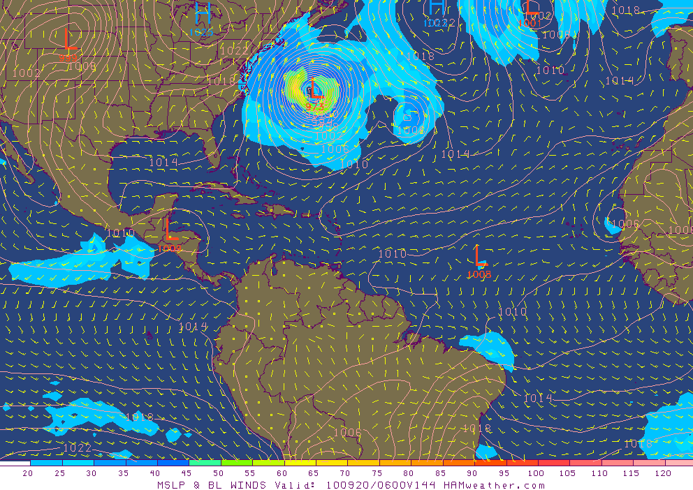 Close Call. Once again the USA will be spared a direct hit. Much like Earl veered out to sea at the last moment, all the computer models show Hurricane Igor taking a jog to the north, staying hundreds of miles east of the Outer Banks, whipping up large swells along the east coast, but no major flooding is expected right now. NOGAPS computer forecast valid early next Monday morning, graphics courtesy of Ham Weather.
 The $700 Million Forecast. Read a great explanation of how satellite and supercomputer technology has revolutionized the tracking and prediction of hurricanes. Last week Hurricane Earl was on a path similar to Floyd, which slammed into the Carolinas in 1999, resulting in hurricane warnings along 1,500 miles of the east coast; millions had to be evacuated inland. In contrast - the supercomputer (track) forecasts have gotten so good that NHC meteorologists were able to place only 450 miles of coastline under hurricane warnings for Earl - ALL the models had the storm staying well out to sea. There were no mandatory evacuations - only a few high-risk areas (barrier islands) were evacuated, resulting in an estimated $700 million in savings to U.S. taxpayers. It's estimated that evacuating one mile of coastline costs $600,000 to $1 million. By accurately predicting the path of Earl, forecasters in Miami were able to prevent a lot of needless (and expensive) evacuations. Not that they didn't have sleepless nights down there (after all, computers often screw up). But when 20+ models are all predicting pretty much the same solution, confidence levels tend to be much higher - that was the case with "Earl." More from the AMS, the American Meteorological Society, here. Yes, the 7-Day will always be a mystery, but all those investments in weather satellites and computers have paid off. I'm a bit biased, but even an objective assessment would show that the USA has the best weather service in the world - with hundreds of private companies (including WeatherNation and Ham Weather) helping to interpret data and add additional value for consumers and weather-sensitive companies.
 Changeable Tuesday. My favorite weather expression: "changeable skies". What the heck is THAT supposed to mean? I've heard it used, when the local meteorologist truly has NO IDEA what's going to happen. Yep, changeable pretty much sums it up. Tuesday fit the definition: a sunny start, followed by patchy clouds (even a few thundershowers south of the Twin Cities) followed by a late-day clearing trend. Highs ranged from 59 at International Falls to 67 in St. Cloud, 68 in the Twin Cities and a balmy 70 in Rochester.
___________________________________________________
Paul's Conservation MN Outlook for the Twin Cities and all of Minnesota:
Today: Gray and cool with rain likely, possibly heavy later today. Winds: E 10-20. High: 62
Wednesday night: Periods of rain, patchy fog possible. Low: 51
Thursday: Drying out - peeks of sun likely, a better day to be outside. High: 64
Friday: More clouds than sun with a passing shower (best chance north). High: 68
Saturday: Intervals of sun - probably dry (the better day of the weekend). High: 64
Sunday: Mostly cloudy and damp with drizzle possible - steadier rain possible late. High: 66
Monday: Rain likely, possibly heavy. High: 67
Tuesday: Windy with showers tapering off - a mostly cloudy day. High: 66
____________________________________________________

Yesterday turned out a little nicer than predicted (we had a few showers in the forecast, and they DID materialize south of the metro area - even a few lightning strikes near Mankato and Cannon Falls). But that's one (of many) problems with giving ONE weather forecast for a very large area. If showers are in the forecast, and it doesn't rain at YOUR HOUSE, the forecast is wrong, right? "But 30 miles down the road it's raining cats, dogs and canaries!" I plead. Nope, you're WRONG Paul, another busted forecast! Ugh. Summer-style, hit-or-miss showers are especially maddening for meteorologists. With Doppler and supercomputer technology it's still impossible to pin down precisely which towns will see rain more than 8-12 hours in advance. It's totally random: all we can do is tell when the atmosphere is ripe for scattered showers, but trying to pinpoint exactly where the drops will fly? Good luck with that. The forecasts become somewhat more straightforward during the fall, winter and early spring months, when precipitation isn't "convective" (showery) but "stratiform" (steadier, heavier rain/snow that covers hundreds of thousands of square miles). EVERYONE gets wet (or white), so it's a lot easier to predict (with much higher confidence) that most everyone will see precipitation of some flavor or another.
No more disclaimers or caveats - just a gentle reminder that there were "scattered showers" yesterday. By the way, we're careful with the words we use to describe the potential for rain.
Here is a rough guideline to go off of:
"Isolated Showers": less than 10% of the area will see any rain.
"Scattered Showers": 10-40% of the area will get rained on.
"Numerous Showers": 48-90% of the area will need umbrellas.
"Rain": implies than 90-100% of the area will see rain.
The reason I use this scheme, and not "probability of precipitation" is this: a 30% probability of precipitation does NOT mean that 30% of the area will see rain, or that it will be raining 30% of the time. No, a 30% "POP" means that, on days with a similar weather pattern, ONE location in the area will pick up at least .01" of rain or more. Baffling. And potentially confusing.
The NAM/WRF model prints out a cool inch of rain later today; after-school activities are in doubt - you may want to consider a Plan B for later today, the best chance of steady/heavy rain coming after lunchtime - into the evening hours. Today should wind up being the wettest day of the entire week.
 Potential Gully-Gushing Rains. Check out the 84 hour accumulated rainfall prediction (NAM/WRF) model, printing out some 1.25"+ rainfall amounts for the western and northern suburbs of the Twin Cities, most of it coming later today and tonight. The model is hinting at some 3-4" amounts north of Fergus Falls (which I'm not buying), but there's little doubt that today will probably be the wettest day of the week - any severe storms rumbling to our south over Iowa (under a slight severe risk from SPC).
Showers taper late tonight, drier Canadian air punches a few sunny holes in our stale cloud deck tomorrow, temperatures stuck in the mid 60s by mid afternoon, not a bad Thursday as Thursdays go. Friday will be a little more unsettled as a fast-moving, almost clipper-like system races across the state, dragging a line of light showers across northern and central Minnesota, the chance of an hour or two of rain much greater in Brainerd and St. Cloud than the Twin Cities, Mankato or Rochester.
The weekend weather looks a little more optimistic - especially Saturday, enough dry, Canadian air leaking south of the border to carve out a few hours of sunshine - in fact skies may be bluer and sunnier the farther north you go. Cabin weather may be considerably better than skies draped over the Twin Cities. A return southerly flow of moisture will spark thick, pasty clouds on Sunday (a little drizzle can't be ruled out), with some heavier, steadier rain possible again late Sunday into Monday - in fact puddles may hang on through the first half of the day Tuesday.
Lovely. Could be worse. No brushfires. No hurricanes. The weather will be far too cool and dry for anything severe through next week. Our weather patterns are on fast-forward, the maps looking more like late September and the first few days of October than mid September. At some point we'll see a bounce, a rebound - more lukewarm 70s, maybe another 80-degree high or two. Don't write summer warmth off just yet...
 Igor Track. NHC computer models consistently keep Igor well out to sea, strong westerlies aloft giving this (extreme) hurricane a gentle eastward nudge long before it has a chance to threaten the east coast of the USA.
 Julia Track. This may just be the year that the USA lucks out, with no direct hits (although it's still way too early to let our guard down). Category 1 Hurricane Julia is also forecast to veer to the northwest and then the north/east - a threat to whales and slow-moving ships. THIS is why you might want to think twice before taking a Carnival Cruise in September. Graphics courtesy of Ham Weather.
 Tropical Storm Karl. Figures, the "male" storm is the weakest of the bunch, only a tropical storm as of last night, 60-70 mph winds may rough up Cozumel and Cancun before re-strengthening in the Gulf of Mexico - probably coming ashore a second time over Mexico by Friday, staying well south of Texas.
 Loveland Fire. Click here to see some (Facebook) photos of the Reservoir Road Fire, near Loveland, Colorado - heavy air tankers dropping thousands of tons of water on the blaze in an effort to get this 650+ acre blaze under control. Hundreds have been evacuated from their homes, nearly 200 dwellings heavily damaged or destroyed in recent days.
 App-World. There are hundreds and hundreds of weather-related apps available for iPhone, Android and Blackberry platforms - 80% of them free, many ad-supported. How are developers going to make money from apps, when so many are giving them away? Good question. Craig Burfeind, CEO of my previous company, Digital Cyclone, told me that there are at least 470 AVIATION weather apps available on the market today. Apple App Store users are twice as likely to download an app than Blackberry or Android users. For every 2 free apps they normally pay for one, which I found vaguely interested. Near the top of the heap: weather and games. Now, if I could only dream up a cool weather game for the iPhone. Hmmm. The story is here.
No comments:
Post a Comment