* Near 80 again today in the Twin Cities, 70s Monday and Tuesday, but cooling into the 60s by midweek. Another warming trend likely by next weekend, when we may see some low 70s again.
* Still no significant rain in sight - isolated T-shower possible later today, another passing shower Tuesday as a cooler front arrives - no major storms brewing looking out 2 weeks or so.
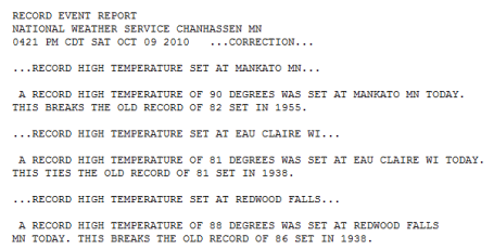
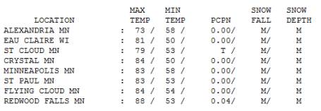
Saturday Records. MSP missed a record by 3 degrees, the old record of 86 set in 1938. But Mankato, Eau Claire and Redwood Falls all set records yesterday - I saw 90 in both Mankato and Waseca (just about 30 degrees warmer than average for the 9th day of October).
Paul's Conservation MN Outlook for the Twin Cities and all of Minnesota
Today: Partly sunny, still unseasonably warm - very slight chance of a T-shower by afternoon. Winds: E 3-8. High: near 80
Sunday night: Partly cloudy and mild. Low: 58
Monday: Mix of clouds and sun, still warmer than average (but nearly 15 degrees!) High: 74
Tuesday: Sunny start, clouds increase - slight chance of a passing shower as a cooler front arrives. High: 76
Wednesday: More sun, cooler breeze - very nice. High: 65
Thursday: Blue sky, beautiful. High: 64
Friday: High pressure drifts overhead - light winds - bright sunshine expected. High: 67
Saturday: Still amazingly nice (for October in Minnesota). Bright sunshine, breezy and milder. High: near 70
The "new normal"
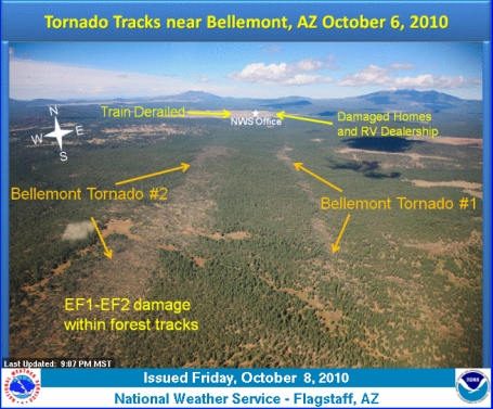
"I'm loving 80s in October, but deep down I find this profoundly troubling," a friend e-mailed me Saturday afternoon. Hot fronts in October? 145 MN tornadoes so far in 2010, still the most in the nation? Summer nights trending much warmer (with more humid, 70-degree dew point days than ever) - even NASA confirming that spring arrives earlier & fall lingers longer than it did a generation ago. No single outbreak of record heat proves anything, but look at the broader picture: a warmer, wetter atmosphere may be loading the dice in favor of more frequent weather oddities: 1 in 500 year mega-floods every 5 years, more volleyball-size hail, like what landed on South Dakota this summer, more tornadoes in unusual places, like Flagstaff, Arizona (where 9 twisters just touched down).
August warmth lingers today, near 80, any pop-up instability T-showers affect less than 5-10% of the state later today. After a slightly cooler front Tuesday, 70 returns for next weekend - no harsh or wintry weather through Oct. 25 or so. One more chance to swing some clubs, hit the trails, enjoy fall color peaking on Highway 61 along the Mississippi River. More time to enjoy The Supersized Autumn of '10.
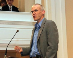
Bill McKibben's Presentation: Climate = Danger. "The acceptable count of carbon dioxide in the atmosphere is 350 parts per million. Scientific consensus says that anything more than that will imperil the planet—the planet’s inhabitants really. We are all in trouble. One-Degree Difference Three-hundred and ninety-two parts per million, that’s the current reality. That marginal increase in heat-trapping carbon gas has already raised the mean global temperature a degree. Even that doesn’t sound like much, one degree. Don’t be fooled. It is too much. “The extra energy that represents in the planet is just enormous,” author William McKibben, the acclaimed environmentalist, scholar in residence at Middlebury College and leading activist in the uphill charge against climate change, told a crowd of mostly blue-blazer students at The Gunnery Tuesday." The complete article in the Litchfield County (CT) Times is here.
No comments:
Post a Comment