
Frost Advisory. The NWS has issued a frost advisory for most of central and southern MN tonight. If you live outside the 494/694 beltway you may want to consider covering up your plants or bringing them indoors (if that's an option). Frost is likely for towns more than 15-20 miles away from downtown Mpls. and St. Paul.
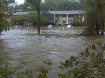

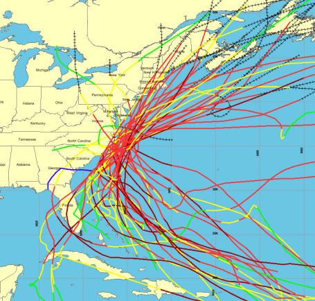
Swamped. "Hurricane Floyd (1999) was supposed to be a 1-in-100 year flood. 11 years later we have another major flood," one resident of Windsor, North Carolina said yesterday. 175 people out of town of 2,000 residents have been evacuated from their homes, due to rising floodwaters. More from CNN/WRAL-TV here.


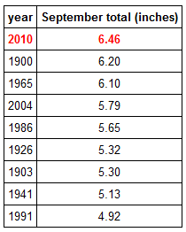
* According to Professor Mark Seeley at the U. of Minnesota September was the wettest on record for Minnesota (average of 6.46" of rain). Many towns in southern Minnesota exceed 10" of rain for the month. Check out his weekly Minnesota WeatherTalk blog here.
* Mississippi River at St. Paul reaches it's all-time high flow rate in Autumn on September 30: 77,400 cfs.
* So far in 2010 Marshall has picked up nearly 36" of rain! Pipestone: 36.25". Windom: 35.15"
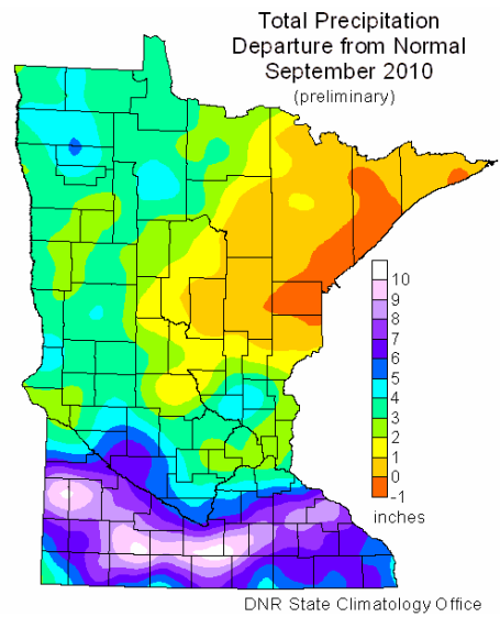
* September temperatures average 2-4 F. cooler than average across much of the state. Twin Cities September temperature: .8 F cooler than normal.
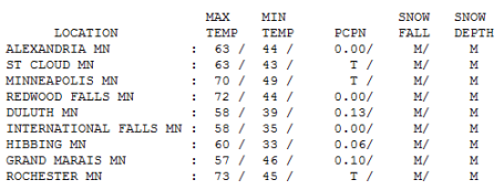
Minor Clipping. The mercury reached 70 in the Twin Cities Friday ahead of an Alberta Clipper. The warmth was fleeting, confined to the southern third of Minnesota - a high of only 63 at St. Cloud and 58 up at Duluth. By the way, last year the high on October 1 was only 51 in the Twin Cities. The heaviest showers stayed just north and east of St. Cloud and MSP (only a trace of rain, enough to dampen up a few sidewalks and driveways), but .13" fell on Duluth.
Paul's Conservation MN Outlook for the Twin Cities and all of Minnesota:
Today: A mix of clouds and sun, breezy and cool. Winds: N 10-15. High: 55
Saturday night: Clearing and chilly - chance of a late-night frost in the outlying suburbs. Low: 37
Sunday: Bright sun, a few degrees milder, the nicer day of the weekend. Winds: S 10-15. High: 61
Monday: Blue sky, getting better in a hurry. High: 65
Tuesday: Sunny - still spectacular! High: 68
Wednesday: Brilliant sunshine, lukewarm breeze - impossible to stay indoors. High: 73
Thursday: Sick of this yet? Me neither. Still sunny, still beautiful. High: 72
Friday: Wrapping up what may be the nicest week of autumn in Minnesota. Lingering sunshine. High: 69
Now THIS is what October is supposed to feel like. Grab a sweatshirt or light jacket before heading out the door today, temperatures will run a good 10-15 degrees cooler than average for October 2 - it will FEEL more like mid or even late October out there, afternoon temperatures stumped in the 50s, the wind making it feel like its in the 40s. But the sun should be bobbing in and out of a rag-tag collection of scrappy cumulus clouds. Skies clear tonight as the center of high pressure drifts overhead. The lighter the winds the greater the probability of a frost across much of the state by Sunday morning. The only exception: the downtowns and close-in suburbs, where some of that "urban heat island" effect will keep temperatures in the mid to upper 30s. On a clear, calm night in autumn the downtowns can be as much as 10-15 degrees warmer than the outlying suburbs, in fact the growing season in Minneapolis and St. Paul is a full 2 weeks longer than it is in Andover, Medina, Lakeville, Stillwater and Cottage Grove. Good news for farmers downtown. Bottom line: if you live within the 494/694 beltway you will probably be frost-free tomorrow morning (and stay frost-free through mid October, the way the maps are looking right now).
Last October saw a quick descent into wintry - we picked up .3" snow on October 10, 2009, with another 2.5" on the 12th (with a high of 36). Yet less than a week later the mercury peaked at 63. Such are the extremes of a typical Minnesota October. But gazing at the latest model runs I see a fairly benign October, 2010 - at least looking out into the third week of October. Next week looks dry - a streak of sunny (gorgeous) days with highs in the 60s and 70s - I could see some mid 70s by Wednesday and Thursday of next week, another distractingly nice stretch of A+ weather. In fact the GFS is hinting at abnormally mild weather (a few more 70s) spilling over into the second full week of October, unusually mild and rather dry through the 15th, give or take. Those same models are hinting at a colder front arriving the third week of October, with highs dropping into the 40s and low 50s - frost/freezing temperatures almost CERTAIN between the 17th and 25th - when reality will take over.
Enjoy the extended weather honeymoon!
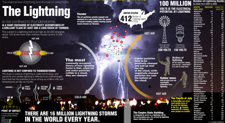
Electrifying Facts. There are an estimated 16 million individual T-storms around the planet every year. The current in a bolt of lightning can be as high as 30,000 amperes. That compares with ordinary household voltage of 200 amps. The Empire State Building in New York City is hit (on average) about 100 times/year. Florida is still the Lightning Capital of the USA - Minnesota has seen only 3 lightning-related fatalities since 2000 (compared to 70 in Florida). More lightning facts than you'll know what to do with here.


No comments:
Post a Comment