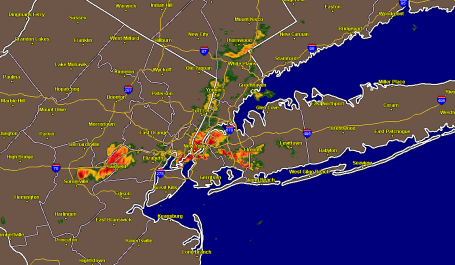
Monday Night Slop-Fest. If you tuned into ESPN for the big Vikes-Jets game Monday night you were treated to a rare rain delay: severe thunderstorms swept through the New York area with high winds, frequent lightning, enough nickel-size hail to cover the ground in some suburbs. Warnings were issued and Jets officials moved players and fans off the field as the worst of the weather rumbled overhead. Unusual for October 11 in New York City? You bet. That's what happens when you get Brett Favre and Randy Moss wearing purple and gold for the first time - fireworks, atmospheric and otherwise!

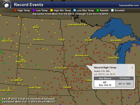
Surplus Of Records. Click here to see a week's worth of records across the Upper Midwest, courtesy of Ham Weather, a division of WeatherNation. All those red dots: all-time record highs. The yellow dots: records for the warmest nighttime lows ever recorded.
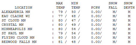
* Monday was the 4th day in a row above 80 in the Twin Cities, the 7th day in a row above 70, typical weather for late August.
* Statewide October temperatures are running 6-10 degrees above normal.
Paul's Conservation MN Outlook for the Twin Cities and all of Minnesota
Today: Partly sunny, slight chance of a shower (even a T-shower over Wisconsin by afternoon). Winds: W/NW 15-25. High: 71
Tuesday night: Partly cloudy, turning cooler. Low: 45
Wednesday: Mix of clouds and sun, closer to average for mid October - still very pleasant. High: 62
Thursday: Plenty of sun, a few degrees milder. High: 65
Friday: Lot's of sun, warmer than average again. High: 66
Saturday: Blue sky, pretty spectacular. High: near 70
Sunday: Sun fades behind increasing high clouds. High: 65
Monday: More clouds, growing chance of a few showers. High: 59
Perspective. A year ago we were waking up to a brisk 28 F. The high was only 36. A total of 2.5" of SNOW fell on the Twin Cities. Do you remember? Talk of an early winter? Commuters were irritable - just about everyone was irritable. There was no "easing into winter" last year, El Nino or no El Nino.
A year later we're still basking in the afterglow of a remarkable spell of weather. Last week was arguably the best week of the entire year. Today will probably be the 8th DAY IN A ROW ABOVE 70 in the Twin Cities! We've just experienced 4 days in a row above 80. In mid October? Remarkable.
There isn't much "weather" out there to dwell on - a cooler front arrives today, starved for moisture we'll be lucky to see a fleeting shower ot two, even a rare October T-shower possible, especially east of the St. Croix this afternoon along the wind-shift line. Behind the front a brisk northwest wind keeping highs in the upper 50s (north) and low 60s (south) Wednesday - the coolest day of the week. We're still in a modified "zonal" flow, jet stream steering winds blowing from west to east, a mild (dry) pattern for Minnesota hanging on straight through the weekend. Winds shift around to the south the latter half of the week, meaning some upper 60s, even another shot at 70 by Friday and Saturday.
I still don't see anything even remotely resembling a "storm" looking out the next 1-2 weeks. Long-range GFS guidance shows a noticeable cool-down after October 27th, at least a few days with highs in the 40s and low 50s (jacket weather). But nothing I'd call a cold front, certainly no arctic air looking out the next 15-20 days. Odds favor a chillier front in time for Halloween (I doubt we'll be basking in the 60s or 60s for Oct. 31).
Welcome to the Year Without An October. Will we pay for this in November? Possibly. Maybe this is atmospheric payback for a cooler, wetter, stormier-than-average September. Enjoy another amazing week here in the Land of 10,000 Weather Extremes. It's turning into one of the nicest autumns in recent history - and that trend will continue for at least another week.


No comments:
Post a Comment