A small, compact, relatively brief storm is moving through town - the heaviest burst is behind us now and snow will taper off to flurries early tonight with no more than another coating to 1" (max). Again, it's not the amounts (which should be barely "plowable" - it's the timing of the snow, coming at the height of the PM rush hour). A little freezing drizzle is possible into the evening hours. By 9 pm we should have our 1-3" accumulation (with a little ice beneath the snow). As much as 4"+ may fall north/east of MSP, from Taylors Falls to Rice Lake, WI. The earlier in the day you can leave - the fewer travel problems you'll encounter.
Storm Headlines:
* Heaviest snow burst over now, light snow tapers to flurries with another 1/2 to 1" possible this evening and early tonight
* Cold enough for mostly snow (a little freezing drizzle can't be ruled out).
* Best bet: 1-3" of snow by 9 or 10 pm tonight. Heaviest burst arrives between 3 pm and 7 pm this evening.
* Many wet interstates/freeways will become snow covered and icy overnight as temperatures fall through the 20s.
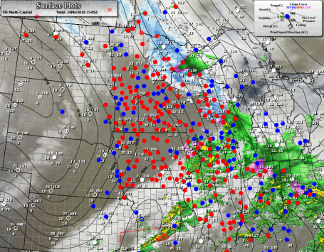
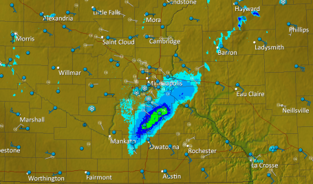
Tracking The Storm. Update: 6 pm. The most significant moisture should pass well south/east of Minnesota today - worried about ice at the airports in the Chicago area, which may trigger some delays this evening. The red dots over MN show "IFR" conditions, low visibility from falling snow, fog and mist.
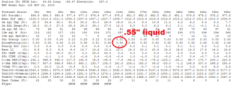
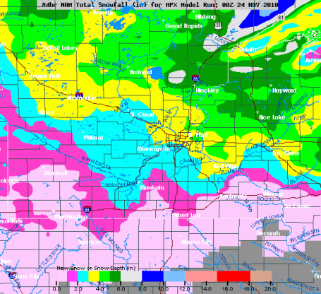
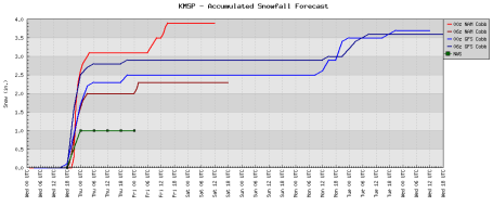
Latest Model Guidance. The WRF model is hinting at .55" liquid from today's burst of snow - suggesting final amounts closer to 4-5" for parts of the metro. The NAM model is predicting closer to 3" of snow. Either way it should be enough to shovel/plow and slow things down later today - although I do NOT expect white-out or blizzard conditions nearby. If you're driving west into the Dakotas blizzard conditions are possible west of the Minnesota line.
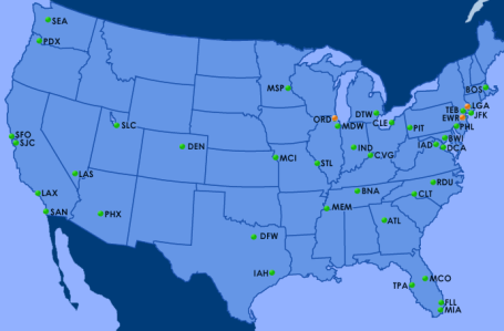
Divine Intervention? Updated: 6:00 pm. So far so good for air travel - which borders on miraculous for the biggest travel day of the year. I don't think our luck will hold out. Ice is moving into Chicago, and visibilities will drop at MSP later this afternoon as snow increases - leading to possible delays. There are significant wind delays at Teterboro, La Guardia and Newark International in NYC. Otherwise all green - pretty good news, all things considered. The later in the day you're flying, the greater the odds of some disruptions. For the very latest airport delays click
here.
Mostly Snow. The lowest mile of the atmosphere should be just cold enough for snow this afternoon into early tonight. A little ice may mix in south/east of MSP, but the predicted profile should keep precipitation falling as snow. That's good news. We were concerned about a thin layer of ice - which still can't be ruled out, especially south of the metro area. The best bet: 2", possibly as much as 3" of snow by early tonight with little accumulation after 10 pm or so.
Doppler Update: 6:00 pm. Snow is already tapering off west of the metro area, maybe another 1-2" south/east of the Twin Cities (mixing with freezing drizzle at time). With surface temperatures falling below freezing later this evening some secondary roads/bridges will become very icy.
Snow Totals? This seems like a reasonable solution: most of the metro area in the 1-3" range (more north/east metro, less south of the cities). As much as 6-10" will accumulate along the North Shore of Lake Superior. South of the metro this will be more of an icing event, a period of freezing rain/sleet likely this afternoon. With ice in the mix travel may actually be worse SOUTH of MSP than north (where precipitation will fall as all-snow).
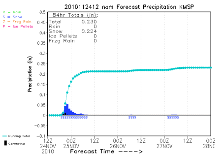
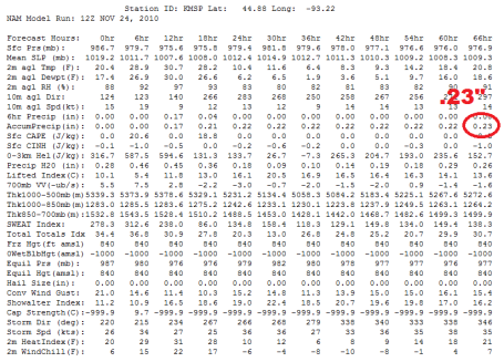
Latest NAM Output. Hot off the wire - the latest amounts are less than the computer runs last night (which were predicting closer to .40 to .50" liquid). The latest model is printing out .23" of liquid. With a 10:1 ratio in place (temperatures in the lowest mile of the atmosphere just below freezing) that should translate into 2, possibly 3" of snow. Far northern/eastern suburbs may pick up closer to 4", less than 1" from Mankato to Red Wing (where more ice will mix in, keeping final snowfall totals down).
Latest Watches/Warnings. Click
here to see the very latest advisories, watches and warnings from the NWS. The entire state is under a winter weather advisory - with winter storm warnings posted for far northern Minnesota, where accumulations of snow will be heaviest. No problems on the east coast - flights should be able to get in later today.
Reasonable Continuity. Our blood pressure drops (a bit) when all the models converge on a single solution, when all models are reasonably close in their snowfall outlook. Not sure how we see less than 1-2" across most of the metro, a few spots may pick up 3 or 4", especially from Anoka and Ham Lake to Hugo, White Bear Lake and Taylors Falls. Yes, it still looks (barely) "plowable".
It's not so much the amount - it's the TIMING of the snow & ice.
No comments:
Post a Comment