The winter months can pose many hazards to those who choose to venture outdoors. With many outdoor activities available in Minnesota and Wisconsin during the winter season, you should be aware of how to keep yourself safe from the cold, ice and snow
Basic Safety Tips
- Avoid overexertion, including when shoveling snow
- Drink plenty of fluids
- Keep yourself and your clothes dry
- Watch for frostbite, and seek medical attention immediately if symptoms are present
What to Wear
- Dress warmly in loose-fitting, layered, lightweight clothing
- Wear a hat. Most body heat is lost through the top of your head
- Wear mittens that are tight at the wrist
- Cover your mouth and nose with a scarf
- Remember that there is no such thing as "100% safe ice" on a frozen lake or pond
- Guidelines for minimum ice thickness: 4 inches for walking and ice fishing, 5 inches for snowmobiling, 8-12 inches for a car or small pickup, 12-15 inches for a medium-sized truck.
- Keep children away from ice-covered ponds and streams
- Take a snowmobile course. Ask your snowmobile dealer to find a class near you
- Avoid drugs or alcohol, as many snowmobile deaths are related to them
- Obey the posted speed limit on snowmobile trails
Minnesota DNR Information Center
500 Lafayette Road
St Paul, MN 55155
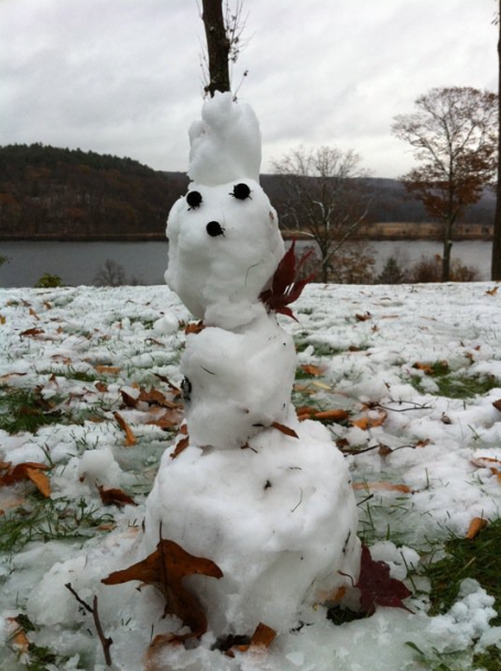
First Snowman Of The Year? No, it's not a home-grown, Minnesota snowman. This shot was taken in Haddam, Connecticut - thanks to Erich Twachtman for reminding us what snow looks like. Connecticut?
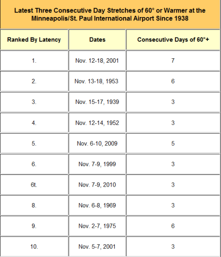
Many communities across the area saw 60° or warmer the past three days, with still a possibility for 60° in a few areas on Wednesday. These readings are 15° to nearly 25° above normal in places. This has been one of the latest three-day stretches of 60° weather in the Twin Cities. Since 1938, a three-day period of 60° or warmer weather has begun in November twelve times in Minneapolis (once every six years). That may not seem as rare as one might think. In fact, just last year had five days in a row hit 60° during the same week...from November 6th through the 10th. The average last 60° day in the Twin Cities is November 6th. (source: Chanhassen National Weather Service)
New Records:
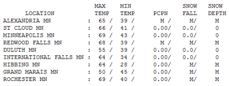
International Falls: 64. Old record: 56 (1969)
* Twin Cities temperatures for November running nearly 7 F. warmer than average through the first 9 days of the month.
Paul's Conservation MN Outlook for the Twin Cities and all of Minnesota:
Today: Clouds increase and thicken, breezy - still unseasonably mild. Drizzle possible by late afternoon. Winds: SE 10-20. High: 65
Wednesday night: A little light rain and drizzle likely. Low: 42
Thursday: More clouds than sun, gusty and cooler. High: 52
Friday: Mostly cloudy - chance of a little light rain (especially south/east of the Twin Cities). High: 45
Saturday: Cloudy start - drizzle or even a few flurries early - then slow clearing. High: 42
Sunday: Intervals of sun - seasonably chilly. High: 44
Monday: Mostly cloudy and raw - a few sprinkles or flurries. High: 41
Tuesday: Seasonably chilly - still mostly gray with a few passing flurries. High: near 40
First Chance of Accumulating Snow? The GFS model is hinting at 1-2" of slushy snow the weekend of Nov. 20-21. Confidence level is low, but I have a hunch we will see our first 1" of snow within the next 1-2 weeks. We're due.
Short post today - just flew back from Washington D.C. (and man, are my arms tired!) I found it ironic that MSP was milder than the nation's capital Tuesday (69 is pretty amazing for Nov. 9 - missed the all-time, modern-day record by a lousy degree).
A mild southeast wind will boost the mercury into the 60s again today, possibly the last day of lukewarm temperatures (until April?) Soak it up - a little drizzle is possibly by afternoon, a period of light rain tonight as colder air surges east across the state. By Thursday it will feel like November again with gusty winds and a cloud-bruised sky. The secondary storm we've been tracking all week will still spin up just to our south and east - a MUCH better chance of a cold rain for Rochester, La Crosse and Winona Friday into Saturday morning (yes, the lowest mile of the atmosphere should be just above freezing - insuring a cold rain). Skies gradually clear Saturday, some chilled sun returning Sunday, but a pool of unusually chilly air aloft may spark a few sprinkles/flurries early next week. Something to look forward to.
Although no big storms are brewing (yet) I have a hunch we may see our first accumulating snow of the season the weekend after next (November 20-21). A white Thanksgiving? Possible - but my hunch is that highs will be above freezing for the next 2 weeks - whatever slush does fall will probably melt in time for Thanksgiving travel. Then again, storms, given a chance, PREFER to come on Thanksgiving - when they can wreak the most havoc on travelers and family reunions - so I'm not going too far out on that shaky, long-range weather-limb.
Bottom line: one more day of relative warmth - then a long overdue reality SMACK by late week. But, for what it's worth, winter is coming later than usual again this year - the winter may seem (a little) shorter this year. Time will tell.
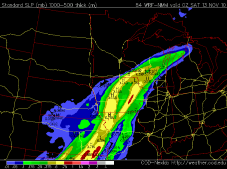
Another Close Call. All the models bring a ripple of low pressure northward along an eastbound cold front - the most significant smear of rain forecast to soak eastern Iowa and Wisconsin, just brushing far southeastern MN. Light rain/drizzle may spread into the metro area Friday into early Saturday - the atmosphere JUST warm enough for a cold rain. No accumulating snow - yet.
No comments:
Post a Comment