* Changeover to snow tonight, but a surge of dry air aloft should cut down on the heaviest amounts.
* Coating to an inch or two in the metro by midday Tuesday. Temperatures fall through the 20s Tuesday, meaning wet/slushy roads will become icier as the day goes on.
* Winter Weather Advisory for the metro area, but Winter Storm Warnings are posted for central/western and northern MN, where some 4-8" amounts are possible.
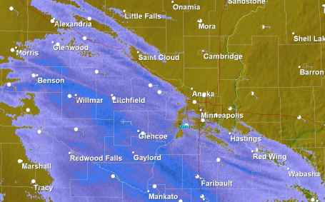
Dopper Update. 2:20 pm. Radar shows all rain for central and eastern MN, but a changeover to wet snow is taking place over far western MN, where roads will be slushy/slick for the drive home later today. In the metro area we expect rain into the evening, little chance of a changeover to snow until 9 or 10 pm. Just about the time it's cold enough for snow a surge of dry air aloft (the dreaded "dry tongue") will cut off the bulk of the precipitation. We should see a few dribs and drabs of snow - but rush hour Tuesday morning may still be slippery and slow.
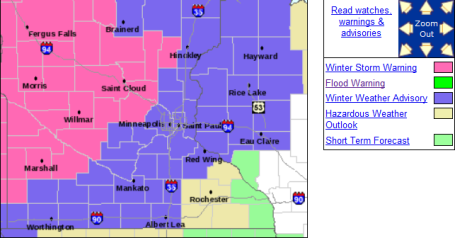
Latest Warnings - Advisories. The Twin Cities metro area (with the exception of Wright County) is under a Winter Weather Advisory. Most of the precipitation will fall as rain today - by the time it's actually cold enough for snow tonight a surge of dry air aloft should cut down the heaviest precipitation. But on the cold side of the storm track mostly snow is expected over western and northern MN from late afternoon through Tuesday afternoon - some 5-10" amounts are possible. Central Minnesota is under a Winter Storm Warning as well, calling for some 2-5" amounts. Tuesday morning travel will be rough, the farther north/west you travel on Highway 10, I-94, Highways 7 and 12 - the worse travel conditions should be. The latest from the NWS is here.
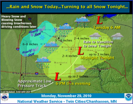
Storm Synopsis. Here's a good summary from the local Chanhassen National Weather Service Office, showing the projected storm track, with the heaviest snow bands setting up well north/west of the Twin Cities. Not sure we'll pick up 2-4". It can't be ruled out, but based on the latest guidance (and that surge of dry air overhead later tonight and Tuesday) I'm thinking closer to a coating to an inch or 2 for the immediate metro - best chance of 2" west metro.
"Nuisance To Plowable." Although only a coating to 1" is expected in the immediate Twin Cities area (to warm yesterday for snow - too dry aloft today for significant accumulation), St. Cloud could wind up with 2-4", with 4-8" from Alexandria and Detroit Lakes to Bemidji - some counties in the Red River Valley may still pick up a cool 8-12" before the flakes stop falling late Tuesday.
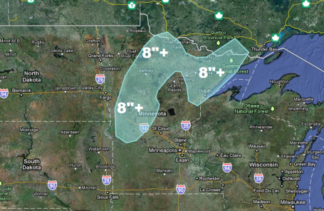
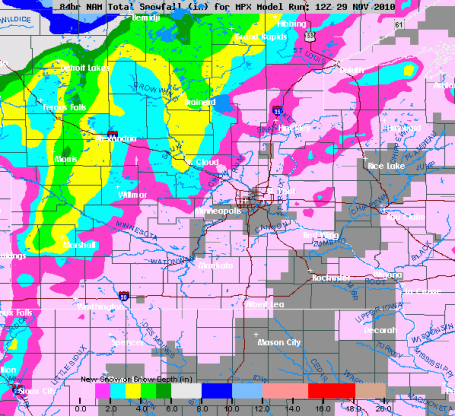
Heaviest Snow Potential. According to NOAA the western third (and roughly the northern half) of Minnesota may pick up as much as 6-8" or more of snow by Tuesday afternoon, the heaviest snow bands setting up 200 miles north/west of the storm track. Maps courtesy of Ham Weather.
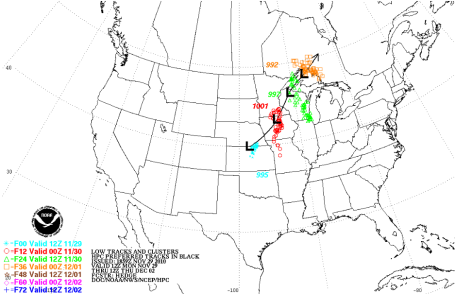
Storm Track. The track of today's storm was too far north/west for significant snow in the Twin Cities. A "perfect" path usually follows a rough line from Des Moines to La Crosse, WI to Wausau. In this case a track 100 miles farther north/west pulled in enough warm air for rain much of Monday, a surge of dry air aloft (the "dry tongue") cutting off snowfall amounts over southeastern and east central MN and western WI.
Paul's Conservation MN Outlook for the Twin Cities and all of Minnesota:
MONDAY: Periods of rain, heavy at times - wet roads for the drive home. High: near 40
MONDAY NIGHT: Winter Weather Advisory. Rain changes to wet snow, about 1" possibly by daybreak Tuesday with slow, slushy travel. Low: 29
TUESDAY: Winter Weather Advisory (Warnings central/north/west). Snow gradually tapers to flurries, windy and colder. Wet/slushy roads will turn to ice. Coating - 2" metro. 5-10" far north/west MN. Turning colder as the day goes on.
7 am: 30
Noon: 26
5 pm: 23
WEDNESDAY: Sun returns, chilly start to December. High: 23
THURSDAY: Mix of clouds/sun - chilly. Good travel conditions. High: 22
FRIDAY: Clouds increase, probably dry. High: 24
SATURDAY: Light snow, coating - 1" possible. High: 31
SUNDAY: Cold wind, flurries linger. Little or no accumulation. high: 29
MONDAY: Sun returns, bitter cold. High: 19
Dreaded "Dry Tongue"
I know, it sounds like something out of a bad deli. Storms are complicated affairs; heavy snow requires a perfect balance of cold air and southern moisture. Too much of either ruins the recipe. But dry air inevitably gets tangled up into a mature storm; a surge of dusty air from the Desert Southwest that invariably cuts down on precipitation amounts. The latest models bring this dry surge right over the metro, meaning a "nuisance snow." A waste of good moisture? Had it been 2-3 degrees colder yesterday's third of an inch of rain would have fallen as 2-4" snow. While the metro sees an inch or two, the farther north/west you travel, away from the metro, the worse conditions will be on the highways. Warnings are posted north/west of St. Cloud: 4-8+" possible.
We dodge a snowy bullet here in the metro, but much of Minnesota will be transformed into a winter wonderland. A cold week is on tap, not as bitter as Thanksgiving. Temperatures run 10 degrees below average. A thaw is possible this upcoming weekend. After today's close encounter with snow I don't see any big stormy headaches looking out 7-10 days or so. A typical November brings 10" snow at MSP. We'll come close this year.
No comments:
Post a Comment