Winter Weather Preparations
- Keep ahead of the winter storm by listening for the latest weather statements, watches and warnings.
- Your vehicle should also be ready. Get it winterized, before the onset of winter weather.
- Be equipped for the worst. Carry a winter survival kit in your car, especially when traveling in rural or open areas. Try to travel with others.
- Yield to snowplows, and give them plenty of room to operate.
- If your vehicle becomes stranded, stay with it until help arrives.
- Do not try to walk for help during a blizzard, you could easily become lost in the whiteout conditions.
- If you will be outside during storms or extreme cold, dress in layered clothing and avoid overexertion.
- Do not kill yourself shoveling snow. Shoveling is very hard work and may induce a heart attack.
- If you will be snowmobiling, avoid alcohol. Most snowmobile deaths are alcohol related. Take a snowmobile course offered by the DNR or check with your snowmobile dealer.
- There were five fatalities in Minnesota last winter when people fell through thin ice.
- Heating fires are a major cause of residential fires in Minnesota. Turn off portable heating devices when you are away from home or retire for the evening. Have your fireplace and chimney professionally inspected before winter.
- Carbon Monoxide is most likely to accumulate inside homes during winter. Check your heating systems and ensure your home has proper ventilation. Install a UL listed Carbon Monoxide detector that sounds an alarm.
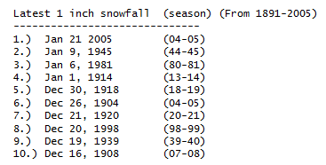
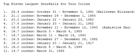
Record Snowstorms For The Twin Cities. Most of us lived through #1). The Halloween Superstorm of 1991, a staggering total of 28.4". By the way, 8 of the biggest 11 snowstorms have hit MSP since 1980! Even though snow totals are trending downward over time, we still get socked every once in a blue moon.

Surprising Tornado Statistics. When you think of "tornado alley" you usually think of Texas, Oklahoma and Kansas, the central and southern Plains states. But SPC statistics show the southern Mississippi and Alabama experience more tornado watches/year (over 16) than Dallas, Kansas City, even Oklahoma City. On average the Twin Cities see an average of 5 tornado watches every summer season. This year that number was closer to 10.
Paul's Conservation MN Outlook for the Twin Cities and all of Minnesota
MONDAY: Hello Late September! Sunny and beautiful. Winds: S 8-13. High: 63
MONDAY NIGHT: Partly cloudy and unusually mild. Low: 43 (close to our average high for November 9)
TUESDAY: Fading sun, breezy, still unseasonably mild. High: 65 (!)
WEDNESDAY: Cloudier and windier, passing shower as a colder front arrives. High: 56
THURSDAY: More clouds than sun, brisk. High: 49
FRIDAY: Brief period of light rain? High: 48
SATURDAY: Gray and damp, most rain stays east. High: 45
SUNDAY: Some sun, feels like November again. High: 42
* Cold enough for a few snow flurries early next week? No accumulation is in sight looking out 10-15 days, but there should be enough cold air aloft for flurries to mix in with instability sprinkles by Monday - Wednesday of next week. The third week of November will DEFINITELY feel like November!
Savoring The Present
"Today is a gift. That is why they call it the present," said Eleanor Roosevelt. At a recent seminar a scientist explained that the average person is only in "the present" for no more than 10 seconds. I tried to top that number, but I was amazing (and a bit horrified) by how quickly to-do lists, tasks & distractions popped up. Try it yourself. Easier said than done. You will want to take your own personal time out: highs reach the 60s today & Tuesday, 15-20 degrees above average. Remarkable.
The most accurate forecasts use computers and meteorologists (to weed through the 30-40 different models that simulate what SHOULD happen looking out 15 days. If you rely only on supercomputers - or human intuition, the likelihood of a "busted forecast" increases. Our taste of late September hangs on through midweek, the first chance of a shower comes Wednesday as cooler air surges into Minnesota.
Models develop a secondary storm along that advancing reality-check; a little rain may brush southern & eastern MN by Friday; just a few hours of puddles. Early next week it should be cold enough for flurries but I still don't see any accumulating snow. For now: unplug, disconnect and enjoy.
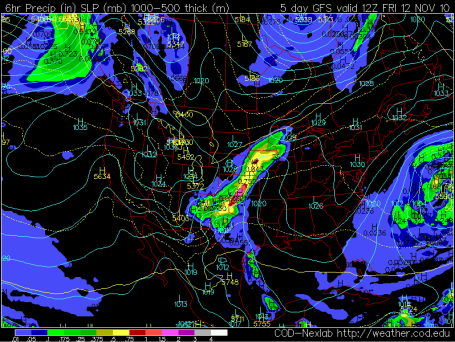
Close Call Thursday Night - Friday? A wave of low pressure rippling north along an eastbound cold front may throw a shield of rain into far southern and eastern MN and much of Wisconsin early Friday - the atmosphere probably just warm enough for rain. Another storm is forecast to spin up farther east on Saturday - by the time it's cold enough aloft for all-snow, most of the moisture will probably have shifted east of Minnesota.
No comments:
Post a Comment