CHRISTMAS EVE: Winter Weather Advisory South/West. 2-4" snow, more south/west of metro. Roads becoming slippery. Winds: E/NE 5-10. High: 28
CHRISTMAS EVE EVE: Light snow tapers to flurries with little additional accumulation. Low: 11
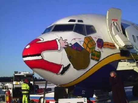
CHRISTMAS DAY: Blizzard of wrapping paper. Gray with lot's of clouds. High: 19
SUNDAY: Chilled sunshine - good travel weather; no issues getting home. High: 14
MONDAY: Blue sky, still cold. Low: -3. High: 15
TUESDAY: Intervals of sun, not quite as numbing. High: 19
WEDNESDAY: Clouds increase, last good travel day? High: 25
THURSDAY: Chance of rain (or ice). High: near 30
NEW YEAR'S EVE: A mix of rain, ice and snow (best chance of accumulation far northern/western MN). High: 29
NEW YEAR'S DAY: A changeover back to mostly snow, some accumulation possible - heaviest amounts probably over central/northern/western MN. High: 27
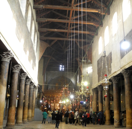
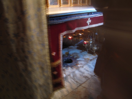
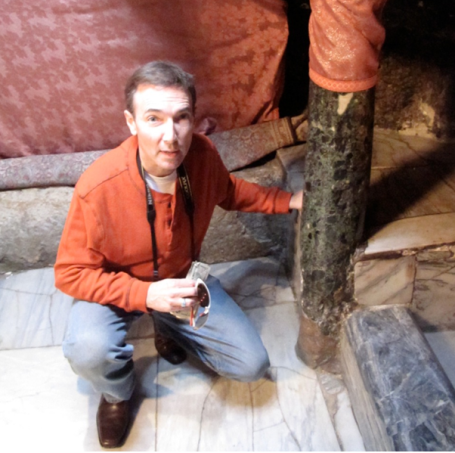
Church Of The Nativity. A week ago my wife, Laurie, and I visited Bethlehem, on the Palestinian West Bank.
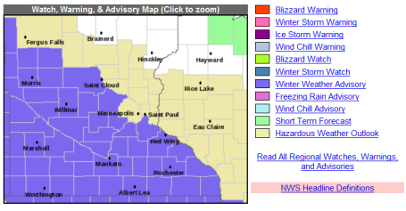
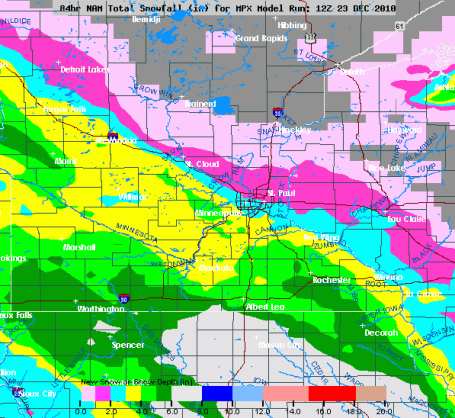
Christmas Eve Overview. Here's the latest from the National Weather Service in Chanhassen - isolating the heaviest snow bands setting up just south/west of I-94. Some 6" snowfall amounts are possible just south of Alexandria and St. Cloud. These clippers are notoriously fickle, a difference of 25 miles can make the difference between an inch and 4". I still believe we'll see a "plowable" snowfall today, the farther south/west you travel away from the metro area the heavier the snow amounts should be.
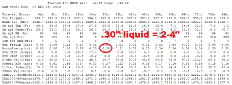
Plowable. The 00z NAM guidance prints out .30" liquid. With temperatures in the mid to upper 20s that should translate into a 10/1 snow/rain ratio, implying about 2-4" of snow for much of the metro.
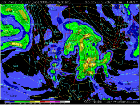
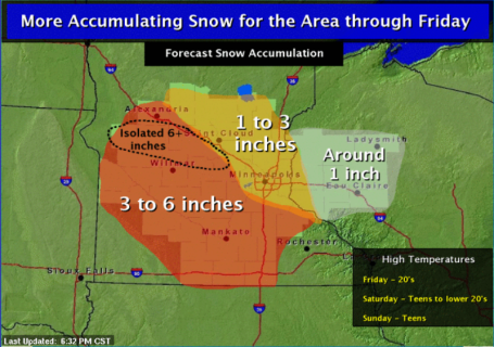
An Icy New Year? It's still a week away, but the GFS model is still suggesting enough warm, moist air may stream northward from the Gulf of Mexico for a period of rain next Thursday/Friday, possibly freezing rain (rain freezing on contact). I could see a significant icing event for much of Minnesota late next week, changing over to mostly snow by New Year's Day, with "wrap-around" snow bands continuing some light accumulation into Sunday. If it were all snow we might be looking at some 6-12" amount, but I believe much of the precipitation will fall as rain, freezing rain or sleet, keeping final snowfall amounts down a bit. If you're traveling late next week you will definitely want to keep an eye on the latest forecast.
Potential for Major Spring Flooding on The Red River Near Fargo/Moorhead? Here is the latest from the National Weather Service hydrologists up in Grand Forks (scroll down to see the text forecast). Hundreds of thousands of variables are factored, including soil moisture going into the winter, the depth of the frost, the amount of water locked up in the current snow, and precipitation forecasts into March and April (we're likely to trend cooler and wetter than average into early spring). A few details:
- Residual Summer and Fall moisture continues to be a concern. Much of the area received five or more inches of above normal precipitation this year, with areas south and east of Fargo receiving nearly a foot above normal of growing season rainfall.
- Areas soils are largely saturated and most rivers are running at seasonally high levels, with much wetter soils in several northern basin areas as well.
These factors typically account for less than half of the variability we see from one spring flood to the next, so clearly the rest of this winter season and the coming spring thaw cycle will likely be our most significant players.
- The latest winter outlook continues to call for a cooler winter and spring season, with slightly above normal winter precipitation expected. High levels of snow or rain like that which occurred during the winter/spring periods in 1997 or 2009 are not expected. However, we have had several consecutive seasons of above normal precipitation.
- The threat of major riverine flooding appears highest along the mainstem Red River, within the Otter Tail basin, along the Sheyenne and portions of the Pembina Rivers. New record lake level increases are also expected for Devils Lake and Stump Lake.

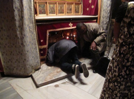
Church of the Nativity
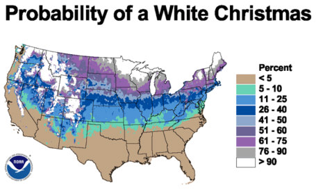
A week ago I visited the Church of the Nativity, in Bethlehem, seeing the spot where Christ was born, parts of the original manger still intact, below the altar of the ornate church. It was a treat to be there so close to Christmas, what may turn into the second "whitest" Christmas on record for the Twin Cities.
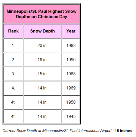
We had 16" on the ground Thursday; if we pick up more than 2" from today's clipper (likely), we'll break the second-place record of 18" set on Christmas Day, 1996. In the unlikely event that 4" falls, we could tie or even break the all-time record of 20" of snow on the ground, set on Dec. 25, 1983. That's the winter we saw a staggering 98.6" snow. I had just arrived in Minnesota, working for KARE-11, and wondered (out loud) what I had gotten myself into!
Highs in the mid to upper 20s should keep freeways mostly wet and slushy today; it won't be as bad as last Monday. I'm thinking 1-3", the best chance of 3" southern and western suburbs.
A gray Christmas Day gives way to chilled sunlight Sunday, great weather for getting home. Dry weather lingers through midweek; an approaching storm may pump enough warm air north for a period of rain/ice late next week, changing to wet snow New Year's weekend. The best chance of heavy snow: far northern and western Minnesota. A mix may keep amounts down at MSP.
Wishing you and yours a very merry (and safe) holiday season.
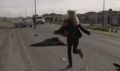
* YouTube video clip courtesy of Safekey Corporation.
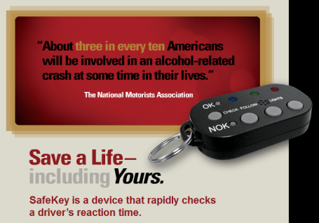
Cheap, Effective Life Insurance. Full disclosure: I'm on the board of Safekey Corporation, a high-tech company on a mission to make DUI's (and stolen vehicles) a thing of the past. For a few hundred dollars you can wire up any vehicle and make it IMPOSSIBLE for an impaired driver (alcohol, drugs, pills, anything) to start up that vehicle. It only takes 2-3 seconds punching a few keys into a special, tiny, pocket-size key fob to "prove" that you're capable of operating a vehicle. This is ingenious technology, designed to prevent catastrophic decisions that leave you or your loved ones vulnerable to DUI, or worse. And at the same time you're getting a theft-deterrent system for your vehicle. Once this thing is wired up there is NO WAY a thief is going to be able to drive off with your car or truck. Zero chance. You can spend over 1K on a Lojack system, or a few hundred dollars for the Safekey system, which is essentially 2 products in one: it prevents you from driving impaired, while simultaneously making it virtually impossible for a knuckle-head to drive off with your car. I believe in this technology - it's already saving lives around the USA. I'm proud to be consulting for Safekey Corporation, proving once again that amazing services and innovations are being launched right here in the Twin Cities. For more information check out their web site.
No comments:
Post a Comment