TODAY: Intervals of sun, 20s feel good. Winds: N 5-10. High: 26
WEDNESDAY NIGHT: Clouds increase - chance of flurries late. Low: 21
THURSDAY: Flurries, steadier snow probably stays south. High: 24
CHRISTMAS DAY: Clouds and flurries. Santa shows up on Doppler late. High: 21
CHRISTMAS DAY: Quiet Christmas, lot's of clouds - cold breeze. High: 19
SUNDAY: More cold sun, good travel weather. No major problems getting home. High: 17
MONDAY: Plenty of sun, still chilly. High: 19
TUESDAY: Dry, clouds slowly increase. High: 22

Jerusalem. My wife of 27 years (Laurie) and I just returned from Israel. We wanted to visit the Holy Land before Christmas - see firsthand what all the fuss is about. As a Christian I wanted to see the places I've been reading about for 45 years. No photos, no words can accurately portray how amazing Jerusalem is, the only city on the planet that is a pillar of all 3 major religions: Judaism, Christianity and Islam. It's an international city with 5,000 years of history - way too much to take in during our 4 full days. But we tried to see a few of the highlights and get a feel for the beauty, the history, and the ongoing conflict. More from Bethlehem later this week. For now I just wanted to mention one non-weather-related item: if you ever get a chance to go to the Holy Land - go. Don't hesitate. You won't regret the time, money or effort to see these sites with your own eyes.
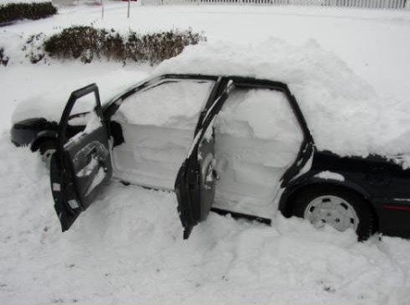
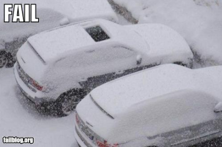
"Minne-snowda". Not exactly sure how this happened (a prank, perhaps?) but when this happens to your vehicle it's probably time to retire somewhere south of Memphis. Talk about a bad day.
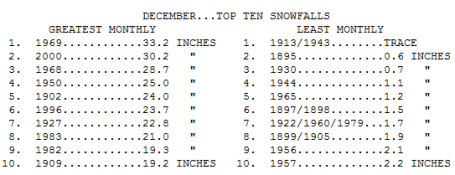
Number 3 And Counting. Twin Cities Snowiest Decembers. 28.8" so far in December, 2010 makes this the 3rd snowiest December in modern-day records. If we pick up just another 4.4" by the end of the month (very possible) this will be the snowiest December since 1891. With close to 39" so far this winter season we've already picked up more snow than during the ENTIRE winters of 2003, 2005 and 2007. Yes, we've been spoiled for much of the past 15-20 years. Now we're getting a real winter, and everyone is panicking. This too shall pass, but not soon enough for many...
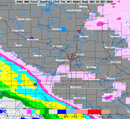
Thursday Clipper. The next system does NOT look terribly impressive - the bulk of the snow passing well south and west of the Twin Cities. Marshall may pick up 2-3", with some 3-6" amounts possible over far southwestern MN, closer to Sioux Falls, South Dakota. RIght now I don't see any big, travel-busting storms or fronts between now and Christmas (and no big weather headaches brewing for the weekend). With any luck getting home Sunday will be a breeze....a cold breeze (highs probably holding in the teens).

* Colorado Mountains could see 8 FEET of snow. The story from USA Today is here.
* Half of the USA To Experience a White Christmas. Santa can park the red SUV and go with the sleigh this year, at least north of a line from Denver to Kansas City, Indianapolis and Baltimore. Data from 2003 - 2009 shows that an average of 37% of the lower 48 states had at least an inch of snow on the ground December 25. More from USA Today here.
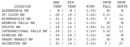
Almost a Thaw. Admit it - 31 felt pretty amazing yesterday, almost mild. 16" on the ground (considerable settling of the snow caused by gravity and the sheer weigh of the snowflakes being compacted). The most snow: Rochester, with 27" on the ground, more than Duluth (21") and St. Cloud (16").
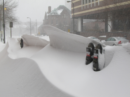
Dangerous Meters. from flickr user I be Owen
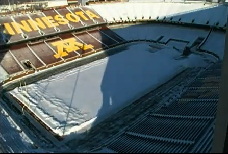
"The same snow whic caused the collapse of the Metrodome early Sunday morning in Minneapolis buried these downtown Minneapolis parking meters Saturday as much of the metro was buried under 15-22 inches of snow."
Adding up the inches
Just back from Israel, where 68 F. has never felt better. To be there, right before Christmas, touring Jerusalem, Bethlehem and the Sea of Galilee, was a bit surreal - and very moving. People asked where I was from. "Minnesota! The snowy state, yes?" Yes!
A record 4.6" fell Monday, bringing out December total to 28.8" (already the 3rd snowiest December for the Twin Cities). If we pick up just 4.4" more snow we'll set a new record for the snowiest December in modern-day records, since 1891. By the way, 38.6" has fallen so far this winter season (3 times more than last year, to date). That is more than fell the ENTIRE winter of 2003, 2005 and 2007. At the rate we're going we may wind up with 60-70" by March, making this the snowiest winter in a decade.
Roughly half of America will see a "white" Christmas this year, a potential for a major nor'easter for New England by the weekend.
Thursday's clipper passes south of Minnesota, no huge pre-Christmas weather headaches brewing. The holiday weekend looks dry & cold (teens, but with some sun). The pattern is shifting: the harshest Arctic air staying north, a "zonal", west to east flow promising a return to more moderate readings.
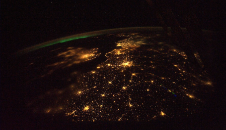
Northern Lights Over Europe. I stumbled upon this amazing image taken by NASA astronauts on board the ISS (International Space Station). Details: "Aurora Borealis in the distance on this beautiful night over Europe. The Strait of Dover is pretty clear as is Paris, the City of Lights. A little fog over the western part of England and London. It is incredible to see the lights of the cities and small towns against the backdrop of deep space. I am going to miss this view of our wonderful world... (11-8-2010)" Check out some of the "Best Of" photos from Colonel Douglas Wheelock, who commanded ISS Mission #25 and has been posting some pretty incredible images on his Twitter account.
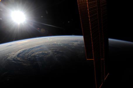
Hurricane Earl. Another eye-popping image from Colonel Wheelock and triggerpit.com: "Out over the central Atlantic, just before another spectacular sunset, with the spiral bands of Hurricane Earl visible in the setting sun. An interesting view of the life-giving energy of our sun. The solar arrays on the port side of the Space Station as well as Hurricane Earl…both gathering the last bit of energy before they fall into eclipse (8-30-2010)."
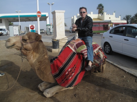
How Do I Get This Thing To Move? This is NOT a "Best OF" photo. That's "Charlie", a foul-smelling, temperamental camel we encountered on the way to the Dead Sea. He probably thought the same thing about me, come to think of it. Not as fast as a snowmobile, but the view from the top was pretty amazing...
How unusual is this westerly movement of the upper low across central Canada which has made for unseasonably warm temperatures across eastern
ReplyDeleteCanada?