Storm Headlines
* No travel problems (weather-related) through the afternoon - clouds increase/thicken as the day goes on.
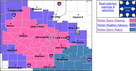
* Winter Storm Warning for tonight:
snow arrives between 4 pm and 7 pm, gets heavier/steadier tonight. Even freeways and interstates will probably become snow-covered with air temperatures close to 20.
* Potential for 3-6" powdery snow by late morning Saturday (average across the metro, the downtowns and close-in suburbs). Less than 2" may fall north of Ham Lake, Hugo and Taylors Falls, but the southern/westernsuburbs (Shakopee, Prior Lake, Chaska, Delano and Waconia) may pick up as much as 5-8" snow.
* Travel conditions slowly improve Saturday afternoon.
* Saturday winds: north at 10-15, meaning minimal blowing and drifting after the storm. Conditions will be ideal for winter weather enthusiasts this weekend.
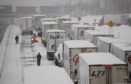
Winter Storm Warning. A watch means "watch out", conditions are ripe for at least 6" or more of snow in a 24 hour period. A warning means it's imminent - it's coming - we probably won't be able to get out of the way of this one. The heaviest snow will fall over a 75 mile wide band. Even a slight (20 mile) jog in the storm track could make the difference between 2" and 7". But it's still safe to assume that the heaviest amounts will fall just south/west of MSP. That said, I still think most suburbs will see enough snow to shovel and plow Friday night, a light, powdery, fluffy (Aspen-like) snow that will result in EXTRAORDINARY ski/snowboarding conditions Saturday. This will NOT be a heavy, wet, slushy snowfall like we had a few weeks ago. Great news for winter weather enthusiasts who want to get out and romp in the snow this weekend. But it's bad news for Friday night travelers - I still believe even freeways and I-94/I-35 will become snow-covered Friday night, in spite of MnDOT's best intentions. With temperatures in the upper teens to around 20 it will be VERY difficult to melt snow/ice. The worst travel comes tonight with rapidly improving conditions during the day Saturday. Click
here to get the very latest details from the NWS.
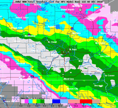
Fickle Clipper. Every storm is different, every storm has its own characteristics and complications. Clippers, by their nature, are extremely fickle and hard to predict, putting down a relatively narrow carpet of white. The NWS is tracking the storm and I think their snowfall predictions are pretty much right on the money. 5-8" for the southern/western suburbs, closer to 3-4" from Coon Rapids to White Bear Lake, Hugo and Stillwater - still enough to shovel and plow. Brainerd and Duluth probably won't see any accumulation from this clipper.
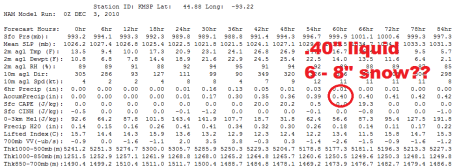
Still On Track for 3-6" (Or More). The 00Z NAM model shows .40" liquid (all snow - the bulk of it falling Friday night). With a surface temperature close to 20 (and temperatures in the lowest mile of the atmosphere in the 15-20 range) the snow/rain ratio could be close to 20/1. 20" of snow for every inch of rain. Higher math: .40" liquid with a 20/1 ratio comes out to 8". I'm discounting a couple of inches (because I just don't trust the models and I still think there's a chance the storm will zig and zag 50 miles farther south). I'm sticking with 3-6", with up to 8" over the western and southern suburbs by late morning Saturday. Roads will be in rough shape Saturday morning with conditions slowly improving Saturday afternoon.
Flakey Friday. The good news: the bulk of the snow SHOULD hold off until later in the day Friday and Friday night. I expect mostly dry roads morning and midday hours, but the chance of snow will increase by mid/late afternoon - it should be snowing in most towns by the dinner hour. The axis of heaviest snow will set up south/west of the downtowns - the southern and western suburbs stand a much better chance of 5-8" than the northern or eastern suburbs, where final amounts may be close to 3 or 4". There may be a HUGE variation in snowfall amounts from northeast to southwest across the metro area. I know it sounds ridiculous to issue a forecast of "2-8" - but that may be exactly what happens with this (fickle), fast-moving clipper.
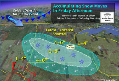
Latest Projections. Models are bringing a band of 4-8" into the metro, best chance of 6-8" far southern and western suburbs of the Twin Cities. I still think 3-6" is a good range for the downtowns and close-in suburbs, just 2-3" for the northern/eastern suburbs, but 10-30 miles southwest of Minneapolis I will not be surprised to hear of some 6-8"+ amounts of powder by late morning Saturday.
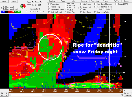
Ripe For "Dendritic" Snow. Unlike the heavy, wet, oatmeal-like snow that fell a few weeks ago (bringing down countless trees and powerlines, making a real mess of things) Friday night's snow will be the kind of snow you'd be apt to see in Aspen or Snowmass - light, powdery, fluffy - quick to accumulate (and unfortunately very slow to melt on area highways). The upshot? The burst of snow Friday night will be accompanied by rapidly rising air, temperatures close to -10 C about 5,000 to 10,000 feet above the ground, with plenty of "omega" - ripe conditions for significant snow, especially south/west of the Twin Cities.
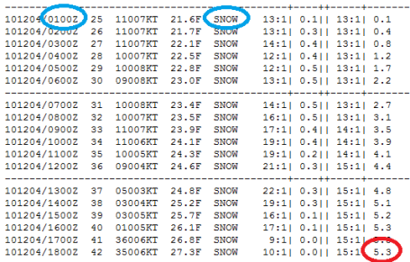
Latest Numbers. The latest NAM guidance suggests snow will move into the metro area around 6 pm Friday - the heaviest burst falling Friday night into the morning hours Saturday. With a 15/1 or even a 20/1 snow/rain ratio the predicted .35" liquid translates into 5.3" of snow, the NAM
hinting at another 1/2 to 1" of additional (wrap-around) snow Saturday evening/night. This seems like a reasonable solution for much of the metro. I think the southwestern suburbs (Chaska, Chanhassen, Shakopee, Le Sueur and Mankato) stand a MUCH better chance of 5-8" than the downtowns.
I still think 3-6" is a good average for much of the metro, just a couple of inches far northern/eastern suburbs, but a significant pile of powder 10-20 miles south/west of Minneapolis.
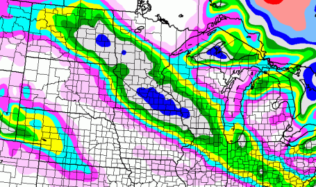
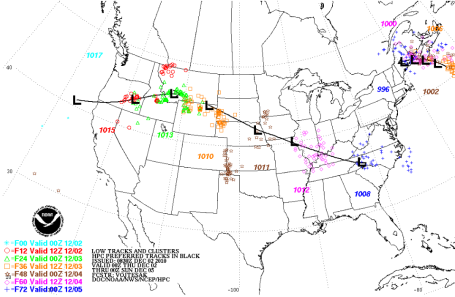
Latest Track. Latest guidance takes Friday night's clipper south of Minnesota (meaning all snow - no question about that). But the track may take the heaviest axis of snow just south/west of the metro - heaviest burst over the MN River Valley, from Montevideo and Granite Falls to Willmar, Mankato and Glencoe.
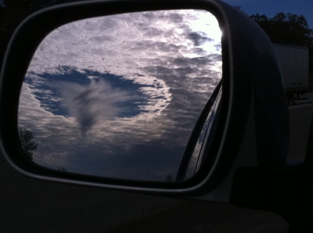
Tracking Strange Clouds Over California. From an
article at KCRA-TV's web site in Sacramento: "
The odd cloud formation spotted in the Sacramento area Wednesday is informally known as a hole-punch cloud, KCRA 3 chief meteorologist Mark Finan said. Finan said a deck of altocumulus clouds was passing over the area.Finan added that the clouds are made up of supercooled water droplets. That is, the water is colder that 32 degrees."
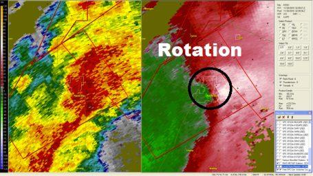
Twice In One Year. You have to feel sorry for residents of Yazoo City, Mississippi. In late April the town was hit by a 1.7 mile wide EF-4 tornado, one that claimed 10 lives. A few days ago the town was rocked by another (smaller) tornado that produced extensive damage to downtown businesses and a trailer park outside of town. Doppler radar tracked the area of intense rotation on the "radial velocity" field. The white region shows air moving rapidly away from the radar site, the bright green shows air moving toward the site - hinting at a "supercell" intense enough to spin up a tornado.
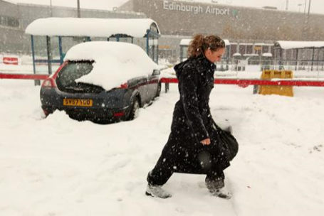
Winter Weather Blasts Europe With Bitter Cold And Heavy Snow. No, we're not alone - it seems much of the northern hemisphere is enduring a premature blast of January-like weather. From an
article in USA Today: "
Officials at Gatwick, south of London, said the airport would remain closed until early Thursday, stranding about 600 flights that were expected to leave Wednesday. Extra staff were working "around the clock" to clear the runways, and passengers were advised to check with their airline or Gatwick's website for updates. Gatwick was under five to six inches of snow Wednesday morning and has seen continuous snowfall throughout the day, said spokeswoman Andrea Hopkins, adding that she was unable to provide a current estimate. Geneva's airport will be closed until at least 6 p.m. Wednesday, a spokesman said. The city has seen 10 inches of fresh snow in the past 24 hours."
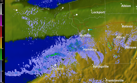
Could Be Worse. Talk about serious lake effect snow. The West Seneca area of Buffalo has picked up 3 feet of snow, and it's still coming down. Some 4-5 foot amounts are possible before winds ease and the snow quits sometime on Saturday. For more details click
here.
 Serious Lake Effect.
 NWS Doppler out of Buffalo Thursday night showed persistent bands of moderate/heavy snow sweeping off Lake Erie, the heaviest (2-4 FOOT) accumulations south of the city. The air temperature is 15 degrees colder than water tempereatures - creating extreme instability. Add an "orographic" effect of moist, unstable air rising up and over the hills of western New York, and you can wind up with extreme upward motion and persistent snow "squalls", capable of dumping 2-4"/hour, complete with thunder and lightning. There is nothing quite as awe-inspiring (at least in the winter) as seeing these mini-blizzards sweeping off the Great Lakes.
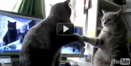
"If Cats Could Talk". Sick of all the clipper-babble? Me too. If you want to take a break from the impending snow and spark a few spontaneous smiles, click on
this YouTube link. Cat lovers will love this clip.
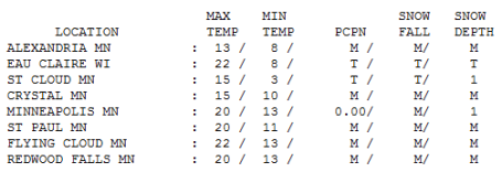
What Month Is This Again? The calendar insisted that it was December 2, then why did it FEEL like January 2? high temperatures were 10-15 degrees below average for early December, ranging from a brisk 13 at Alexandria to 15 in St. Cloud to 20 in the Twin Cities, a balmy 22 at Eau Claire.
Paul's Conservation Minnesota Outlook for the Twin Cities and all of Minnesota:
TODAY: Winter Storm Warning. For Tonight. Clouds increase. Snow arrives by late afternoon/evening. Winds: SE 10-15. High: 22
FRIDAY NIGHT:
Winter Storm Warning. Moderate snow - travel becomes very tricky. Low: 19
SATURDAY: 3-6" snow totals in the metro (more south/west, less north/east of St. Paul). Flurries by afternoon with slowly improving travel conditions. High: 25 (winds north at 10-15, only minor blowing/drifting behind the storm).
SUNDAY: Bitter sun, better travel statewide. High: 15
MONDAY: Blue sky, "early January" Low: -1. High: 13
TUESDAY: Partly sunny, cold & quiet. Low: 3. High: 19
WEDNESDAY: Mix of clouds and sun. High: 25
THURSDAY: Clouds increase, not quite as cold. High: 28
The Perfect Storm?
Bear with me here. My logic may be twisted but there is some method to my madness. The snow is still coming. A clipper drops a narrow carpet of light, powdery (Aspen-like) snow tonight. What makes this a perfect storm? The brunt of the snow will come well after PM rush hour, when most of us are snoozing tonight. Unlike a few weeks ago this will NOT be a heavy, wet, oatmeal-like snowfall. This will be pure "Minnesota powder" - creating ideal conditions for sledding, skiing, snowboarding and snowmobiling this weekend. Unlike many storms whatever falls will stay on the ground for a long time to come. The first chance of a 32 F. thaw? December 15. That snow isn't going anywhere anytime soon.
Every storm is different, clippers uniquely fickle; a narrow, 75-100 mile wide band of heavier, "plowable" accumulation.
If I issued a forecast of 1 to 8 inches the men with the little white jackets would show up to take me away. But that's exactly what is on tap tonight. An inch for Hinckley, 2-3" White Bear and Stillwater, 3-6" for much of the metro; 5-8" from Willmar to Shakopee and Mankato. Snow gives way to Arctic sunshine, a bitter start to the new week. Time to dig out the parkas.
Weather's Perils, Fiscally Considered. Here is an interesting
article from the New York Times. It tracks the adventures of PHd meteorologist Megan Linkin, who is an "atmospheric perils specialist." She must have her hands very full these days. From the article: "
Making models: My job is not to predict the weather; it’s using research to come up with a risk landscape that helps our underwriters figure out rates for the future based on climatic hazards. My focus now is on a model for hurricanes, so I use research dating from 1851 to 2009. Previously I did a model for tornadoes and hail. Learning the business: The job is very different than I thought in that I’m learning so much about business and finance. I guess the prevailing opinion is that it’s easier to hire the scientist and teach them business than hire a business person and try to teach them the science. Weather derivatives, catastrophe bonds, alternative risk transfer products: This is not a static field."
Top 10 Android Apps. Say what you will about the Apple iTunes App Library being a tightly controlled (policed) "walled garden" overseen by Steve Jobs. It works. The Android marketplace is an utter nightmare by comparison - a lot of apps (more like "craps") that really shouldn't be there. Bob Tedeschi at The New York Times has some ideas on some of the must-have apps for an Android world
here.
*
Global Experts: Warming Could Double Food Prices. From a recent AP
article: "
Change apparently already is under way. Returning from northern India, agricultural scientist Andrew Jarvis said wheat farmers there were finding warming was maturing their crops too quickly. "The temperatures are high and they're getting reduced yields," Jarvis, of the Colombia-based International Center for Tropical Agriculture, told reporters last month. For most farmers around the world, trying to adapt to these changes "will pose major challenges," Wednesday's IFPRI report said.Research points to future climate disruption for agricultural zones in much of sub-Saharan Africa, south Asia and parts of Latin America, including Mexico. In one combination of climate models and scenarios, "the corn belt in the United States could actually see a significant reduction in productivity potential," Nelson told reporters here."

No comments:
Post a Comment