Weather Headlines:
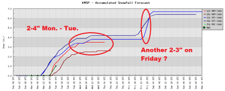
* Series of (significant) clippers this week. Snow develops today, lingers into much of Tuesday, 1-2" today, another 1-2" possible Tuesday,
potential for a total of 2-4" by late Tuesday in the metro area, over 6" for parts of southwestern Minnesota.
*
Second clipper arrives Friday with a few more inches, possibly enough to shovel/plow.
* Turning colder over the weekend, potential for
subzero highs over much of Minnesota by Sunday.
*
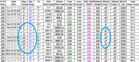
An even colder front brewing for the end of next week: 3-4 days of subzero highs in the metro, nighttime lows may dip to -25 F. between January 21-25. Up north temperatures may fall into the -40 range during that same period.
* Historically temperatures "bottom out" next next couple of weeks. With a rising sun angle temperatures
should begin to trend upward again in late January and early February.
*
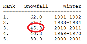
Third snowiest winter on record, to date. Since November 29 MSP has experienced 30 days with at least a trace of snow (details below).
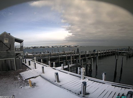
Nantucket Harbor. This (terrific) photo of the snowy, windbown aftermath of a nor'easter courtesy of
Twitpic.
Third Snowiest Winter. As of January 7, 2011, 45.3" snow had fallen at MSP. According the gurus down at the Chanhassen office of the National Weather Service, that makes this the 3rd snowiest winter (to date), at least since 1940. There have been three 6"+ snowfalls so far this winter (Nov. 13, Dec. 3-4 and Dec. 10-11). Only the winter of 1983-84 had more 6"+ snowfalls (a total of 4 as of January 7). Three 6"+ snows ties '92, '97 and 2001. Click
here to read more from the National Weather Service.
* Since November 29 we've had 30 days with at least a trace of snow in the Twin Cities. In the last decade only one winter (2005-2006 had more days with a trace or more of snow during a 40 day period).
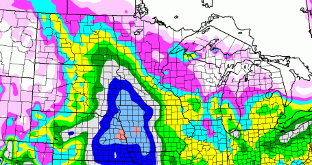
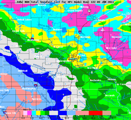
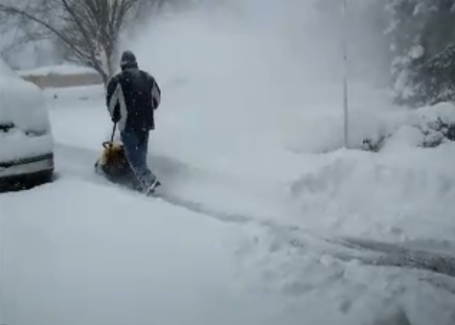
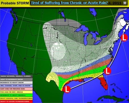
Speaking of Snow. A long-lasting snow event is likely later today into much of Tuesda as an area of low pressure tracks well south of Minnesota, an "inverted trough" throwing a shield of light snow into Minnesota. The heaviest amounts (5-10") is still expected to fall over southwestern Minnesota. The farther south/west you travel, away from MSP, the worse highway conditions will be, especially this evening through Tuesday.
Another Huge Range In Expected Snowfall. Welcome to another stomach-churning, gray-hair-inducing snow event. The models are suggesting 3-4" snow for the metro area by Tuesday PM, with the heaviest amounts over the far southern and western suburbs, where some 5"+ amounts are possible. Yes, this should be "plowable", "shovelable", enough to foul up commutes, especially Tuesday morning.
A Snowier Week. At least when it's cold, single digits and low teens, you can be reasonably assured that the storm track has been pushed too far south of town for significant snow, that old "too cold to snow" thing. Some truth to that, I guess. But as the mercury edges closer to 20 the chance of accumulating snow often increases. The models are in pretty good alignment, indicating a few inches today and Tuesday, another shot of snow Friday as Arctic air returns.
Bitter Blast - Coldest of Winter? Last week at this time a number of people thought I was mad predicting a bitter outbreak more than 2 weeks away. But we're still on track for a news-worthy bout of Siberian air, best chance of subzero weather from the 20th through the 25th of January. We may still experience 3 or 4 days of subzero highs in the metro (-3 to -8 F. range) with nighttime lows dipping to -25, even colder in the outlying suburbs. I'm still expecting a rash of -40s up north, maybe a -50 up at Embarrass and Tower, the twin cities of cold. Yes, we may set a few all-time records for January cold later this month. Give it about a week and a half and everyone will be griping...
South Bend Snow Blitz. Over 25" of snow in South Bend in a 24 hour period, setting a new daily snowfall record. You Tube footage
here.
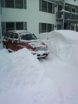
Car-Eating Drifts.Those are some serious drifts smothering northwest Indiana. Snowfall amounts downwind of the Great Lakes are historically as much as 3 to 4 times more than the upwind side of the lakes. Snow lovers are thrilled, commuters not so much. A timelapse of the car getting dug out from 30" of snow is
here.
Science of "Lake Effect". The University of Wisconsin CIMSS weather blog delves into the science behind lake effect snow, how a prolonged (and lengthy) "fetch" of icy air passing over the relatively warm waters of Lake Michigan - coupled with a cold twist of air in the upper atmosphere conspired to create over 2 feet of snow in a 24 hour period for the South Bend, Indiana area.
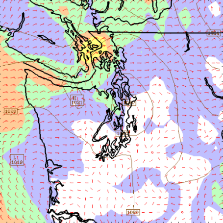
Seattle Dumping? Models are hinting at some 6-12"+ amounts between Seattle and Portland later this week. More from Cliff Mass on his Pacific Northwest
weather blog.
A Very Active Week. Larry Cosgrove, in his WEATHERAmerica
blog, dives into what should be a very active week of weather for much of the nation, a possibility of glaze ice from Texas to South Carolina, and another major storm for the east coast. The latest NAM model is printing out close to a FOOT of additional snow for New York City on Wednesday. Here we go again.
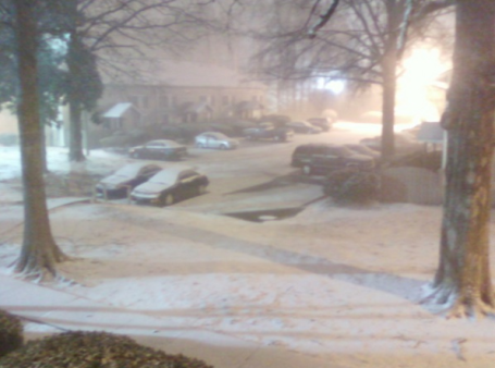
"Hot-Lanta? Not Exactly" Here is a Twitter photo from the Atlanta area Sunday evening, a couple of inches wreaking havoc. Click
here to see the latest weather-related Twitter photos coming in from the snow/ice event in the south, courtesy of breakingnews.com.
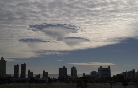
"Hole-Punch Clouds". WeatherNation meteorologist Susie Martin forwarded this photo of a crazy-looking sky over Myrtle Beach, South Carolina on Saturday. Snow is falling out of that mid-level deck of altocumulus clouds, evaporating before reaching the ground, resulting in a classic example of "virga."
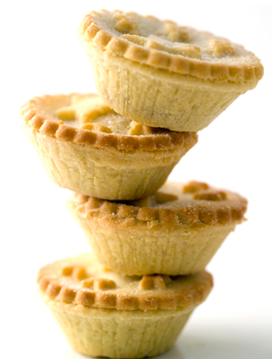
Cupcakes Are Dead. Long Live The Pie! An intriguing story from NPR. Personally, I'm not convinced cupcakes are doomed. We'll see....food for thought from the
article: "Every year, I predict the death of the cupcake. I'm always wrong. But this year, they'll have real competition from the humble pie. Trend-spotters are calling pie the food of the year. Texas and New York restaurants offer pie happy hours. Pies are showing up at weddings, and pie shops are opening in a neighborhood near you. Pies come in sweet and savory, maxi and mini, deep dish and deep-fried. If pies are the new cupcakes,
New York Magazine says, vegetables are the new meat." Say what?
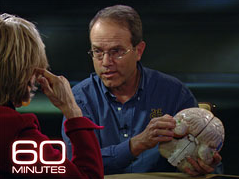
The Gift Of Endless Memory. Superior Autobiographical Memory, a real mouthful for an amazing capability to recall every day of your entire life. Apparently a handful of people have this gift/curse - able to recall everything they did on any day. It's not photographic memory or some kind of trick - these people are wired differently. It's been reported recently on the Today Show and this 60 Minutes
episode - absolutely amazing. Remember Marilu Henner from "Taxi"? She has it - click
here to see her brain in action, which is truly impressive. Like a walking, talking computer. Google (with a heart and soul). Imagine the fun at parties? Sadly, according to my son, I have the opposite of autobiographical memory. I'm lucky if I can remember what I did yesterday.
Cheap GPS.
Paul's Conservation Minnesota Outlook for the Twin Cities and all of Minnesota:
TODAY: Snow likely, couple of inches by tonight - roads become slippery. Winds: East. 8-13. High: 23
MONDAY NIGHT: Light snow continues, still icy. Low: 19
TUESDAY: Another 1-2" snow possible, still slick. High: 24
WEDNESDAY: Just flurries, better travel. A colder day. High: 14
THURSDAY: Peeks of sun, easier commute. High: 13
FRIDAY: Another "plowable" snowfall? Few inches expected. High: 15
SATURDAY: Snow tapers to flurries, colder. Travel conditions slowly improve. High: 9
SUNDAY: Bright, ineffective sunshine. Low; -9. High: 1
Tundra Tales
Welcome to the third snowiest winter (to date) since 1940. 45.3" so far, three storms have dumped 6" or more of snow. Only one other winter (83-84) had more "six-inchers" as of January 7, according to the National Weather Service.
We're about to add to that number. As impossible as it sounds, the approach of an even colder cold front will set off a flurry of meaty clippers this week, a cool 3 or 4" today into Tuesday, maybe a couple more inches of powder Friday. By Sunday temperatures may have a tough time climbing above zero in the metro under a helpless sun.
But wait, there's more. Long range guidance is still hinting at the coldest outbreak of winter coming by the following weekend (January 22-23), when metro "highs" may be in the -5 to -10 F. range, lows dipping to -25 F. You can exhale now. That SHOULD be the worst of it. All uphill from there. Famous last words.
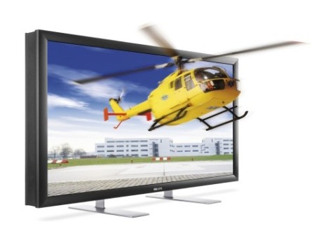
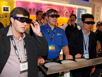
Just back from the Consumer Electronics Show in Las Vegas. I was skeptical of 3-D, but it's amazing. Hey, we live in a 3-D world. 3-D games and sports make you feel like you're there. That, and Internet-connected TV, enabling personalization we can only dream about today. A 3-D warm front? That sounds nice.
CES 2011. I just returned from Las Vegas. While there I got a look at 3-D television (and laptops) and I have to say I'm pretty impressed. I went out there expecting to be underwhelmed, but the experience is really quite extraordinary. There's no way to grasp the concept unless you don the (dorky) glasses and check it out, first-hand. The world is 3-D, why not experience it that way? The only way I can describe it is - you feel like you're truly there. Having that third dimension is immersive and overwhelming, similar (in some respects) to going from black and white to color, or even SD to HD. I have mixed feelings - it will make (some) programs even more compelling and memorable. The downside: it will make it even harder to turn off the boob tube.
*
Sony displayed a concept of 3-D television without the glasses. It was on a 24" OLED TV set, but it was quite spectacular. Not sure how long before that (easier) version of 3-D shows up on the market, but chances are it will be worth the wait.
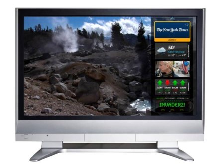
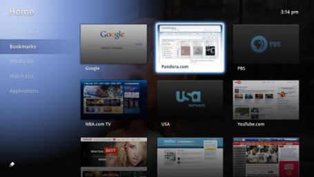
* I was also impressed with the slate of
Internet-enabled TV's displayed at CES, the imminent marriage of television and Internet which will lead to some very powerful new forms of programming. The sets available today are pretty crude, with limited apps, everyone sees pretty much the same thing. What has me most excited is the capacity to personalize information - filter out the content (and advertisements) you're not interested in. In the not-too-distant future we may all be watching our own (personalized/tailored) newscasts. A personal weather channel for every one of us? Stay tuned.
A "Dumbing Down" Effect From Google Television? Is "smart television" in trouble, scripts with nuance and complicated plot twists in grave peril? An interesting
post from tvweek.com: "
With this week’s Consumer Electronics Show in Las Vegas showcasing high-tech tweaks on the TV model such as Google TV, veteran industry reporter Tim Goodman, writing in The Hollywood Reporter, warns that the changes that are on the way for television could have unintended consequences. Among those consequences, Goodman writes, is the possible “dumbing down” of the medium as television content evolves to match the needs of multitasking users aided by killer apps such as the new “dual-view” feature--the picture-in-picture of the future. Goodman writes: “The dual-view feature combines what a lot of people are already doing--surfing the Web or texting while watching TV--but makes it a whole lot easier. It might be the tipping point toward the death of subtlety and dense, intelligent television.”
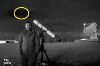
Astronomer Misses Meteor On Live TV. From a
post in the U.K.'s Asylum: "
He was there to show the public how to spot interesting sights in the night sky -- which made it all the more embarrassing for astronomer Mark Thompson when he missed seeing a meteor on live TV. During the recent BBC series 'Stargazing LIVE' Thompson had been advising people on how to identify constellations and see other things worth looking out for. But on one of the live shows - speaking from a field near Jodrell Bank - he said that cloud cover was so bad there was nothing interesting to see... and that's when it happened. As he uttered the words "Hello, still here in the wacky cloudy skies of Macclesfield," a meteor whizzed across behind him in what appeared to be the only bit of clear sky that night."
 January To Be The Coldest Since 1985. Where's Global Warming?
 I'm still amazed by the number of sane, rational people confusing weather with climate. Livescience tackles the topic in
this article. An excerpt: "
Climate change won't absolutely get rid of cold days, or even months, but we'll probably have fewer of them, and the ones that we do have will be less intense," said David Easterling, chief of the Scientific Services Division at NOAA's National Climatic Data Center. "So what if it's unusually cold since, wow, 1985? That's not a big deal in the context of time. Next year may be really warm, but you can't just take one winter and say, 'where's global warming now?'"
Global Warming Is Real, We Ignore It At Own Peril. From an
article at the Guardian: "
Research on ice cores and lake sediments show that the climate system has suffered other abrupt fluctuations in the distant past. The climate appears to have "tipping points" that can send it into sharp lurches and rebounds. Although scientists are still analyzing what happened during those earlier events, it's clear that an overstressed world with 6.3 billion people is a risky place to be carrying out uncontrolled experiments with the climate. Julius Ningu, a director in the environment department in the office of Vice president said in an interview this week that the current warming trend is expected to cause extinctions. “Numerous plant and animal species, already weakened by pollution and loss of habitat, are not expected to survive the next 100 years. Human beings, while not threatened in this way, are likely to face mounting difficulties” said Ningu. He said recent severe storms, floods and droughts, for example, appear to show that computer models predicting more frequent "extreme weather events" are on target.“The average temperature of the earth's surface has risen by 0.74 degrees C since the late 1800s. It is expected to increase by another 1.8° C to 4° C by the year 2100 - a rapid and profound change according to environmentalist” he added."
 The Catastrophe Of Climate Change Skepticism
. Here's an
excerpt from the Pacific Free Press: "U
nlike in politics or painting, when it comes to climate change, the opinions of laypersons are not relevant. In the face of another diplomatic disappointment in Cancun’s climate change talks, we approach the end of the hottest year on record. While experts again try to ring alarm bells, our media still gives voice to the pseudo-intellectual pursuit of climate skepticism. Perhaps while Rome burned, some bravely questioned the finer qualities of fire. Perhaps on Easter Island, as the last trees fell, some elders courageously debated the necessity of wood. Today, our own Margaret Wente and Rex Murphy sing in tune with the likes of Glenn Beck, sincerely believing their skepticism to be a form of intellectual virtue. It is not.
German chancellor Angela Merkel calls the low-carbon economy the “third industrial revolution.” A new energy internet supplied by clean energy sources like biomass, wind solar, hydro, and geothermal is spread across the continent. There are new storage technologies like compressed air and low-friction flywheels. Large-scale efficiencies make economies more competitive. If Canada gets it right, we’ll sell this stuff to the rest of the world. The transition to a low-carbon economy brings huge economic opportunity, but it is not optional."
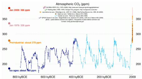
Time History of CO2.
Here is a You Tube timeline showing atmospheric concentration of CO2 dating back 800,000 years to the present.
No comments:
Post a Comment